History of Oceanography
1/46
Earn XP
Description and Tags
Name | Mastery | Learn | Test | Matching | Spaced | Call with Kai |
|---|
No analytics yet
Send a link to your students to track their progress
47 Terms
European Voyages of Discovery
1400-1500’s
Founding of Oceanography as Science
1800’s
Phoenicians, Polynesians, Arab Fleet
Early Civilization
Voyages of Learning
1700’s
Science declines but navigation improves
500-1400 A.D.
Advancements in sounding, drilling, study
1900’s
Greek scientists produce atlas and catalog life
400-100 B.C.
Ferdinand Magellan
1st to go around / circumnavigate the Earth, died in the Philippines
Leif Erickson
Made 1st European voyage to North America
Matthew F. Maury
Physical Geography of the Sea on currents
Ptolemy
Made 1st World Atlas
Christopher Columbus
Made 4 voyages to the “New World”
Aristotle
Cataloged marine organisms by characteristics
James Cook
Charted the Pacific including Alaska and Hawaii, he died in Hawaii
Charles W. Thomson
Chief Scientist on HMS Challenger
HMS Challenger
1st vessel dedicated to oceanographic research
Meteor (Vessel)
Measured ocean depths using echo sounding
What did the Vikings do?
Colonized Iceland and Greenland
What did the Polynesians do?
Colonized the Pacific and Hawaiian Islands
Muslim Fleet
Established and controlled trade to India and China
Phoenicians
Established trade through the Mediterranean
Where was Cook killed?
Hawaii
Where was Magellan killed?
The Phillippines
Accurate watch
Used to measure longitude
Satellite
Used for remote sensing
“Father of Oceanography”
Maury
HMS Endeavor
Reports still used today, was James Cook’s Ship
Who tried to reach the west indies?
Columbus
Portolanos
Harbor finding charts
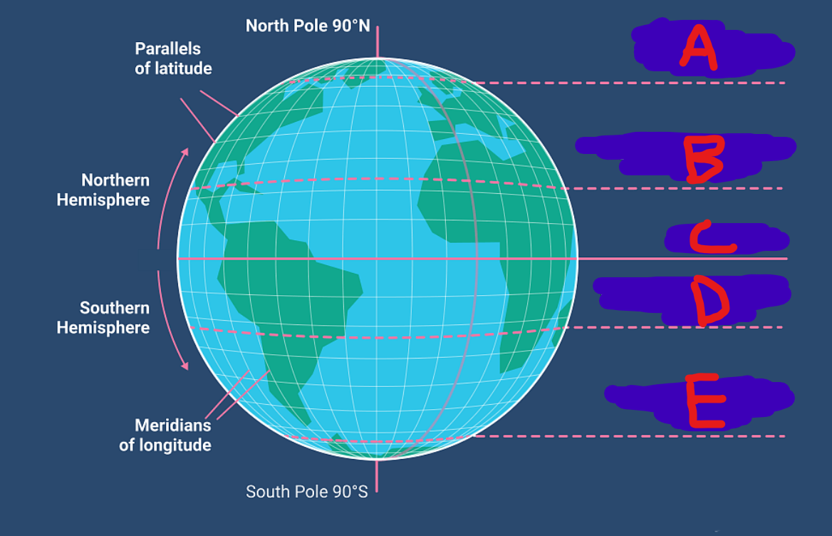
What is letter A?
Arctic Circle [ 66.5 NORTH ]

What is letter B?
Tropic of Cancer [ 23.5 NORTH ]

What is letter C?
Equator [ 0 DEGREES ]

What is letter D?
Tropic of Capricorn [ 23.5 SOUTH ]

What is letter E?
Antarctic Circle [ 66.5 SOUTH ]
Prime Meridian
0 DEGREES Going UP and DOWN
International Date Line
180 DEGREES W/E
Laws of the Sea
International rules governing oceans in order to maintain peace
The Laws of the Sea are based on what?
Customs
The Laws of the Sea are based on what?
Treaties
The Laws of the Sea are based on what?
International Agreements
UNCLOS meaning
United Nations Convention on the Law of the Sea
When was UNCLOS last updated?
1994
Has the US Congress ratified the UNCLOS treaty?
No
EEZ meaning
Exclusive Economic Zone
How far does the EEZ extend from a nation’s shore?
200 miles
How far do territorial waters extend from a nation’s shore?
12 miles
High Seas
Any part of the Ocean not inside the EEZ of any nation