2.a how are glacial landforms developed? - spec
1/23
There's no tags or description
Looks like no tags are added yet.
Name | Mastery | Learn | Test | Matching | Spaced |
|---|
No study sessions yet.
24 Terms
the influence of weathering on geomorphic processes - chemical
Oxidation
Process:
Oxygen reacts with iron-rich minerals, forming iron oxide (rust), which weakens rock integrity.
Causes reddish staining on rock surfaces and weakens cementing agents holding mineral grains together.
Common in iron-rich sedimentary rocks, such as sandstone or basalt.
Influencing Factors:
Presence of oxygen-rich water – More active in temperate environments where oxidation occurs in wet conditions.
Rock composition – Most pronounced in iron-bearing rocks, where oxidation breaks down mineral bonding.
Carbonation
Process:
Rainwater absorbs CO₂ from the atmosphere, forming a weak carbonic acid.
This acid reacts with calcium carbonate in limestone, dissolving rock and leading to karst landscapes.
In caves, carbonation contributes to the formation of stalactites and stalagmites, as dissolved calcium bicarbonate precipitates during evaporation.
Influencing Factors:
CO₂ levels – Higher atmospheric CO₂ concentration accelerates carbonation.
Temperature – More effective in colder conditions, common in glacial regions.
Solution
Process:
Certain minerals (e.g., salts, gypsum, limestone) dissolve in water, weakening rock structure.
Highly soluble minerals break down quickly, leading to extensive erosion.
Some minerals dissolve only in highly acidic water (pH ~3), contributing to selective weathering.
Influencing Factors:
Water acidity (pH levels) – More effective in acidic environments with a pH below 5.
Rock type – Most common in limestone and gypsum, which easily dissolve.
the influence of weathering on geomorphic processes - physical
Frost Shattering
Process:
Water trapped in tiny rock pores freezes and expands, increasing volume and creating stress.
Repeated freeze-thaw cycles weaken rock structure, causing fragmentation into small particles.
Common in cold, dry environments where water seeps into porous rock.
Influencing Factors:
Temperature extremes – Most effective in polar regions where temperatures drop well below freezing.
Rock type – Occurs in highly porous rocks, such as sandstone, which allow water infiltration.
Freeze-Thaw Weathering
Process:
Water enters cracks and joints in rocks.
As temperatures drop, water expands by nearly 10%, exerting strong outward pressure on rock walls.
Over time, repeated cycles cause rock fragments to break off, accumulating as scree slopes beneath cliffs.
Influencing Factors:
Temperature fluctuations around 0°C – Requires regular cycles of freezing and thawing.
Altitude – Higher elevations (e.g., Alpine regions) experience seasonal thawing, increasing freeze-thaw effects.
Rock permeability – Occurs most effectively in fractured, jointed rocks, where water can enter small spaces.
Pressure Release (Dilation)
Process:
As glacier ice melts and retreats, the removal of overlying weight allows the underlying rock to expand.
Expansion leads to the formation of parallel fractures, also called pseudo-bedding planes.
Common in intrusive igneous rocks, such as granite, which previously had significant pressure from glacier weight.
Influencing Factors:
Ice thickness – Heavier ice = greater expansion stress upon melting.
Rock type – Granite and other deep-seated rocks are highly prone to dilation fractures.
the influence of weathering on geomorphic processes - biological
Tree Roots & Burrowing Animals
Process:
Roots penetrate rock joints, exerting outward pressure and gradually widening cracks.
Over time, root expansion causes rock fragmentation.
When trees topple, their roots pull rock and soil upward, exposing fresh surfaces to additional weathering.
Burrowing animals (e.g., rabbits, moles) loosen rock material, contributing to breakdown.
Influencing Factors:
Vegetation cover – More common in glacial margins, where trees establish roots.
Soil type – Looser soils enable deeper root penetration, increasing weathering intensity.
Organic Acids (Chelation)
Process:
Decomposing plant material releases organic acids that react with minerals in rock.
This process breaks down mineral structures, weakening rock surfaces.
Certain algae and fungi accelerate weathering by producing biofilms of iron and manganese oxides.
Influencing Factors:
Presence of decomposing organic matter – Common in forested areas near glaciers.
Microbial activity – Increased fungal and bacterial presence leads to greater mineral breakdown.
the influence of mass movement on geomorphic processes
the influence of glacial erosion on geomorphic processes
Plucking
Process:
Meltwater seeps into joints and cracks in bedrock, freezing and bonding to the glacier.
As the glacier moves, it pulls chunks of rock away, leaving a jagged landscape behind.
Key Influences:
Occurs most effectively on jointed or previously weathered rock surfaces.
Requires meltwater, so is mostly found at the base of warm-based glaciers where ice reaches the pressure melting point (PMP).
Abrasion
Process:
Ice at the glacier's base carries debris, grinding against bedrock and scraping the surface.
Clear ice alone cannot erode—it requires embedded rock fragments to scratch the surface.
Debris itself wears down due to friction, forming rock flour, giving glacial meltwater its milky color.
Key Influences:
Glacier thickness – Thicker glaciers exert more downward pressure, increasing abrasion rates.
Basal debris amount – Up to a point, more debris increases erosion, but excessive debris causes too much friction, reducing movement.
Debris size & shape – Large, angular particles enhance abrasion, while small debris has a lesser effect.
Relative hardness of debris and bedrock – Abrasion is most effective when hard debris scrapes softer bedrock.
Basal sliding – Requires glacier movement; faster sliding increases erosion.
Estimates of erosion rates:
Embleton & King (1968) estimate active valley glacier erosion at 1,000–5,000m³ per year.
The Glacier d’Argentière eroded a marble plate at 36mm/year under 100m thick ice moving at 250m/year.
the influence of nivation on geomorphic processes
What is Nivation?
Nivation refers to a collection of weathering and erosion processes that occur beneath seasonal or permanent snow patches, leading to the formation and enlargement of hollows. It is not a single process, but a combination of several interacting mechanisms.
Processes Involved in Nivation
Freeze-Thaw Weathering
Repeated freezing and thawing of water in rock cracks weakens the underlying bedrock.
The expansion of ice exerts pressure, causing rock fragmentation.
Meltwater Erosion
As snow melts, water infiltrates soil, loosening sediments and rock particles.
Flowing meltwater carries debris downslope, further deepening the hollow.
Solifluction
Saturated soil becomes unstable, slowly moving downhill due to gravity.
This process occurs seasonally, transporting weathered debris away from the hollow.
Chemical Weathering
In regions with limestone or carbonate-rich rocks, meltwater dissolves minerals through carbonation.
This weakens the bedrock, contributing to hollow formation.
Formation of Nivation Hollows
Snow collects in depressions (north-facing slopes in the Northern Hemisphere experience less melting, allowing persistent snow patches to remain).
Weathering and erosion beneath the snow weaken the rock, leading to slope failure and sediment removal.
The hollow expands over time, eventually deepening enough to develop into a corrie or cirque glacier.
the influence of transportation on geomorphic processes
Transportation in Glacial Systems
Moving ice carries large amounts of debris from various sources:
Rockfall – Weathered rock falls onto the glacier from valley walls.
Avalanches – Ice and rock debris move downslope due to gravity.
Debris Flows – Meltwater mixes with loose sediments, transporting material further.
Aeolian Deposits – Fine particles blown by wind, collecting on glacier surfaces.
Plucking – Large chunks of bedrock become embedded in glacier ice.
Abrasion – Smaller rock fragments are scraped away from valley floors and sides.
Classification by Transport Position:
Supraglacial – Carried on the glacier’s surface due to rockfall and weathering.
Englacial – Found within ice, originating as supraglacial debris covered by snowfall or pushed into crevasses.
Subglacial – Embedded in the glacier base, derived from plucking and abrasion.
the influence of deposition on geomorphic processes
1. Formation of Glacial Landforms
Moraines – Deposited till forms ridges marking past glacier extents.
Drumlins – Streamlined hills of glacial till, shaped by ice movement.
Eskers – Long, winding ridges formed by meltwater streams depositing sediment beneath glaciers.
Outwash Plains – Extensive areas of sorted sediment deposited by meltwater beyond the glacier.
2. Sediment Redistribution and Landscape Evolution
Till Deposits – Unsorted glacial debris influences soil composition and drainage patterns.
Fluvioglacial Deposits – Meltwater transports and sorts sediments, shaping valleys and floodplains.
Glacial Erratics – Large boulders transported and deposited far from their source, altering local geology.
3. Interaction with Erosion and Transportation
Deposition occurs when glacier energy decreases, leading to sediment accumulation.
Glacial retreat exposes deposited material, influencing post-glacial erosion rates.
Deposited sediments can stabilize slopes, reducing further erosion.
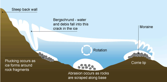
corries
Corries (also known as cirques in North America and cwms in Wales) are armchair-shaped hollows formed by glacial erosion.
nivation
ice formation and rotational movement
plucking and abrasion - erosion of the hollow
formation of the lip - erosion slows
tarn formation
formation of corries
Corries (also known as cirques in North America and cwms in Wales) are armchair-shaped hollows formed by glacial erosion. Their development follows a series of geomorphic processes:
1. Nivation – The Starting Point
Snow accumulates year after year in hollows on a hillside.
Freeze-thaw weathering breaks down bedrock beneath the snow patch.
Meltwater erodes underlying material, deepening the hollow and preparing it for ice formation.
2. Ice Formation and Rotational Movement
As accumulation continues, snow compresses into firn and then into glacial ice.
At critical depth, the ice begins rotational movement, aided by:
Pressure melting point (PMP) – meltwater lubricates movement.
Subglacial debris – sharp rock fragments enhance abrasion.
3. Plucking and Abrasion – Erosion of the Hollow
Rotational movement causes plucking along the back wall, making it steeper.
Debris from weathering and freeze-thaw falls into the bergschrund crevasse, contributing to erosion.
Abrasion deepens the hollow, especially at the base where pressure is highest.
4. Formation of the Lip
Erosion slows at the front of the corrie due to thinner ice, leaving a higher lip.
Moraine deposits accumulate, further shaping the lip structure.
5. Post-Glacial Landscape – Tarn Formation
Once the glacier retreats, the hollow fills with water, creating a tarn (corrie lake).
The lip acts as a natural dam, holding water within the corrie.
Key Energy Influences on Corrie Formation
Gravitational Potential Energy (GPE) – Enables rotational movement.
Kinetic Energy – Drives abrasion and plucking processes.
Thermal Energy – Minimal requirement for accumulation, as snow mainly forms in cold conditions.
Example – Red Tarn, Helvellyn, UK
Red Tarn in the Lake District sits within a classic corrie.
Steep back wall formed by plucking and deepened basin due to abrasion.
Moraine deposits contributed to the raised lip holding water.
aretes
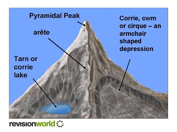
formation of aretes
Two or more corries are formed leaving a narrow ridge between them
Erosional landforms
Formed by plucking - plucking will still contribute to abrasion
Perhaps frost shattering
pyramidal peaks
When a hill has been heavily eroded with 3 or 4 corries the jagged hill that is left is known as a horn or pyramidal peak
Plucking, frost shattering, GPE, Thermal Energy
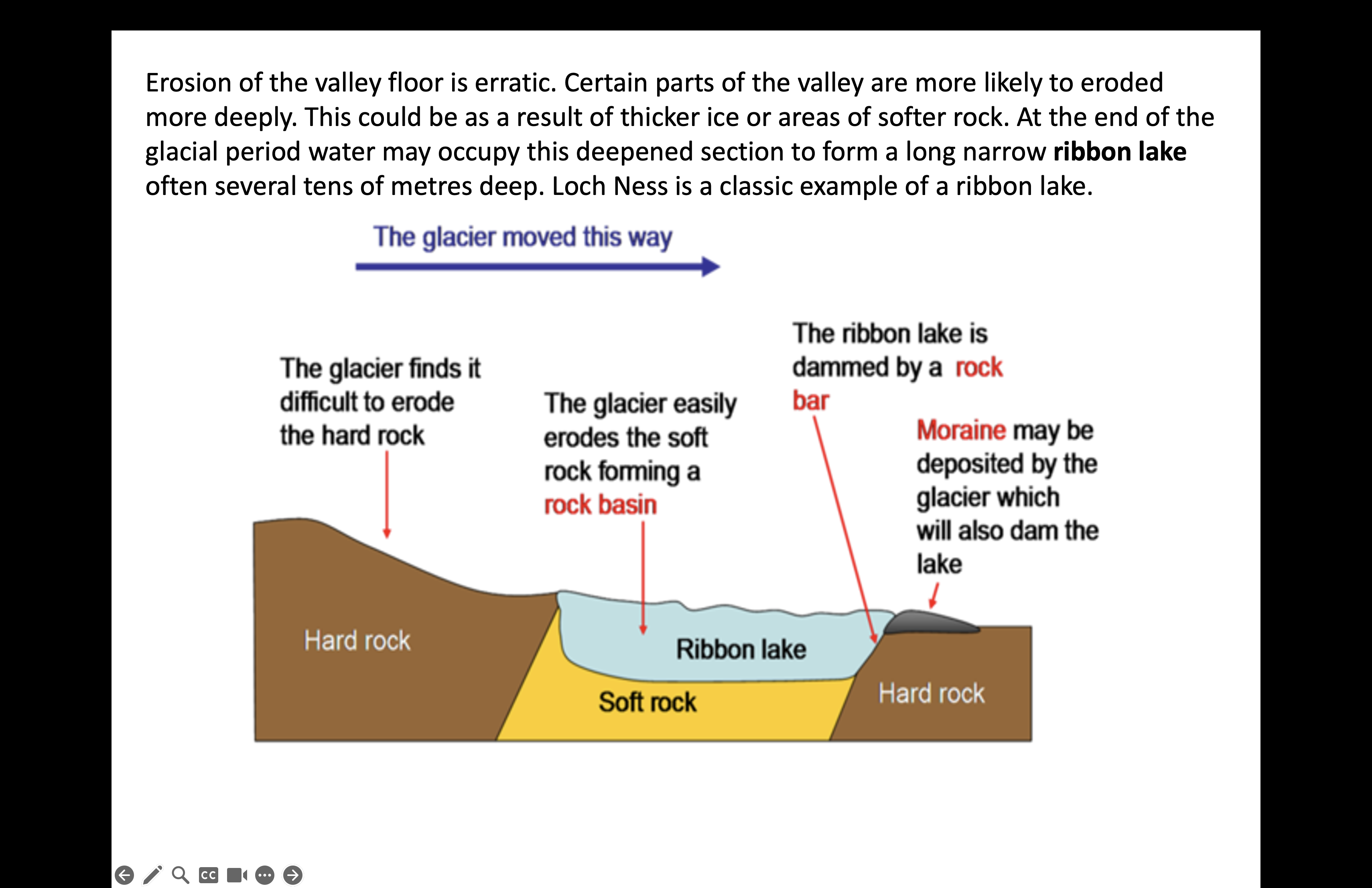
formation of glacial troughs
glaciers flow down pre-existing river valleys under gravity
glaciers erode sides and floor of valleys in upland areas causing valley shape to become steeper, wider and straighter
morphology of the trough (cross and long profiles) may depend on the geology
long profile of the trough is influenced by type of ice flow such as extending and compressive flow
processes of glacial erosion include plucking and abrasion
scale / rates of erosion depends on a wide range of factors such as characteristics of the basal debris being transported, ice thickness and basal water pressure
trough formation also depends on pre- and inter- glacial weathering processes especially freeze-thaw / frost shattering and pressure release
troughs may include depositional features such as various types of moraine and scree slopes
roche moutonnee
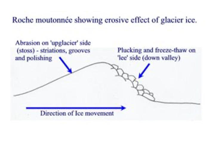
formation of roche mountonnee
Glacier Moves Over Bedrock:
As ice advances, it encounters a protruding rock obstacle in the valley.
Erosion begins as ice moves over it.
Pressure Melting Point (PMP) and Meltwater Production:
The glacier’s weight exerts pressure on its base, lowering the pressure melting point (PMP).
Ice at the base melts due to this localized increase in pressure, generating meltwater.
Smoothing of Upstream Face (Abrasion):
Meltwater lubricates movement, allowing ice to slide over the rock.
Embedded debris abrasively smooths the upstream side, sometimes leaving striations (scratches).
Plucking on the Downstream Side:
As the glacier moves over the crest, pressure decreases, and meltwater refreezes.
Ice adheres to the rock surface, plucking chunks of bedrock as the glacier moves forward.
This process steepens the downstream slope, leaving behind a rugged, fractured surface.
Characteristic Shape of Roche Moutonnée:
Smooth, gently sloping upstream side due to abrasion.
Steep, jagged downstream side caused by plucking.
formation of striations
On the valley floor, striations can be found carved into the bedrock.
These are long gauges or scratches in the rock where moraine has been dragged over the bedrock - formed from abrasion
They run parallel to the direction of ice movement and therefore can be used to calculate the direction of ice movement once the ice has retreated
^ these are all to do with warm based, valley glaciers
terminal moraine
A terminal moraine is a ridge of unsorted glacial debris (till) deposited at the furthest point of a glacier’s advance. It marks the maximum extent of glacial movement before retreat.
Formation Process:
Glacier Transporting Sediment:
As the glacier moves, it pushes and carries debris picked up from erosion.
Accumulation at the Glacier Snout:
As the glacier loses energy and starts melting, it drops its load at the snout (terminus).
Continuous movement bulldozes debris forward, forming a ridge.
Glacial Retreat and Moraine Stabilization:
As temperatures rise, the glacier retreats, leaving the moraine exposed.
Over time, weathering and erosion modify the moraine’s shape.
Key Features:
Forms crescent-shaped ridges following the glacier’s front.
Composed of unsorted material ranging from fine silt to large boulders.
Can act as a natural dam, leading to the formation of proglacial lakes.
lateral moraine
A lateral moraine is a ridge of glacial debris deposited along the sides of a glacier. It forms due to the accumulation of rock and sediment that falls onto the glacier from valley walls.
Formation Process:
Rockfall from Valley Slopes:
Weathering processes like freeze-thaw loosen rocks, which fall onto the glacier’s surface.
Transport by Glacier Movement:
Debris remains on the surface, carried along the glacier’s sides.
Unlike subglacial sediment, lateral moraines are not embedded within ice.
Deposition as Ice Melts:
When the glacier retreats, the debris is left behind, forming parallel ridges along valley edges.
Over time, lateral moraines may become prominent ridges, influencing drainage patterns.
Key Features:
Linear ridges running parallel to a glacier’s path.
Composed of unsorted till (rock, boulders, and finer sediment).
Often visible in post-glacial landscapes, marking past glacier extent.
recessional moraine
A recessional moraine is a ridge of glacial debris (till) deposited during temporary pauses in a glacier’s retreat. Unlike a terminal moraine, which marks the furthest extent of a glacier, recessional moraines indicate intermittent halts in retreat.
Formation Process:
Glacier Advances and Deposits Debris:
Initially, ice pushes debris forward, forming a terminal moraine at its furthest reach.
Glacial Retreat with Temporary Pauses:
As climate conditions fluctuate, glaciers pause during retreat, allowing sediment to accumulate.
Each pause results in a new ridge forming behind the terminal moraine.
Deposition of Unsorted Material:
Like other moraines, recessional moraines consist of till (rocks, boulders, clay, and silt).
They typically appear as multiple parallel ridges, reflecting different retreat phases.
Key Features:
Found behind the main terminal moraine.
Forms multiple ridges indicating past glacier stabilization points.
Composed of unsorted sediment, reflecting glacial transport
erratic
Erratic Characteristics and Formation
Erratics are large glacially transported boulders that rest in a location with a contrasting geological composition from their origin.
They often sit on pedestals, as they shield underlying rock from weathering and erosion.
Erosion mechanisms such as plucking or rockfall initially detach erratics from their source.
They are transported supraglacially (on the glacier’s surface) or englacially (within the ice) before eventual deposition.
Role of Energy Flows in Erratic Transport and Deposition1. Kinetic Energy – Glacier Transport
Moving glacier ice carries erratics across vast distances, embedding them in glacial debris.
Once transported, erratics can be found hundreds of kilometers from their original bedrock formation.
2. Thermal Energy – Glacier Melting and Exposure
During periglacial periods, solar energy melts ice, exposing erratics.
Long-term exposure to thermal radiation ensures the erratic is no longer encased within ice.
3. Kinetic Energy – Further Movement Post-Deposition
Erratics may shift due to mass movement, especially when resting on unstable slopes.
Avalanches or landslides can reposition erratics further downslope.
4. Meltwater Streams and Kinetic Energy Influence
As glacial meltwater flows through valleys, it may carry erratics further downstream.
Smaller erratic fragments can be transported within outwash channels, contributing to post-glacial sediment movement.
drumlins
Drumlins are elongated, teardrop-shaped hills composed of glacial till, formed beneath moving ice sheets. Their formation remains debated, with two key theories explaining their origin:
1. Subglacial Sediment Deformation Theory (Soft-Bedded Drumlin Formation)
Occurs in areas with soft, deformable sediments beneath a glacier.
As the glacier moves, subglacial meltwater pressure increases, leading to the mobilization and reshaping of sediment.
Ice flow molds sediment into streamlined shapes, aligning with the glacier’s movement.
2. Obstacle-Based Erosion and Deposition Theory (Hard-Bedded Drumlin Formation)
Forms when ice encounters a resistant obstacle, such as bedrock or compacted sediment.
Ice accelerates over the obstacle, causing erosion at the upstream side and deposition at the downstream side.
Leads to a whaleback shape, with steep stoss (upstream) slopes and elongated lee slopes.
Both processes contribute to drumlin fields, where multiple drumlins appear aligned with past glacier movement.
till sheets
Formation Process:
Till sheets form when large masses of unstratified glacial debris (till) are deposited by retreating ice sheets.
They often appear flat or gently undulating, smoothing the underlying landscape.
Their extent varies depending on the glacier’s size and movement history.
Composition and Variability:
Till characteristics are influenced by the rock types over which the ice traveled.
Areas with high clay content experience greater compaction, leading to a denser, more consolidated deposit.
Minnesota, USA:
Extensive Laurentide Ice Sheet deposits shaped the regional landscape.
Till left behind after retreat contributed to fertile plains and diverse geological formations.
till plains
Formation: Created when large masses of unstratified drift are deposited at the end of a glacial advance, covering the landscape.
Composition: An unsorted mixture of rocks, clays, and sands.
Transportation: Primarily carried as supraglacial debris, later forming moraines during both active ice movement and glacial retreat.
Rock Characteristics: Individual stones are sub-angular—not fully rounded but also not sharp like frost-shattered rocks.
Influence of Underlying Geology: The composition of till reflects the bedrock over which the glacier moved, e.g.:
East Anglia, UK – Covered by chalky till due to ice passing over a chalk escarpment