Year 9 Earth
1/54
Earn XP
Description and Tags
Name | Mastery | Learn | Test | Matching | Spaced |
|---|
No study sessions yet.
55 Terms
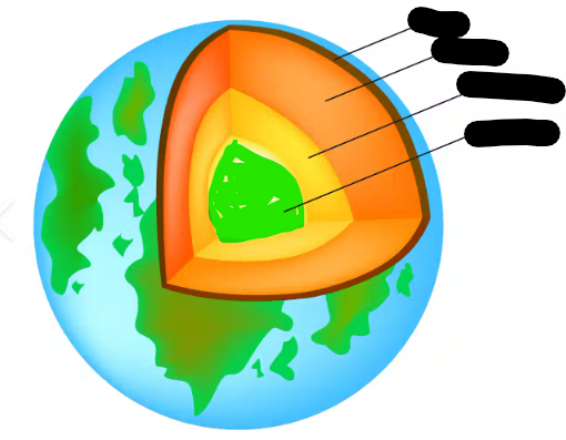
what is this
inner core
What is this
outer core
What is this
mantle
What is this
crust
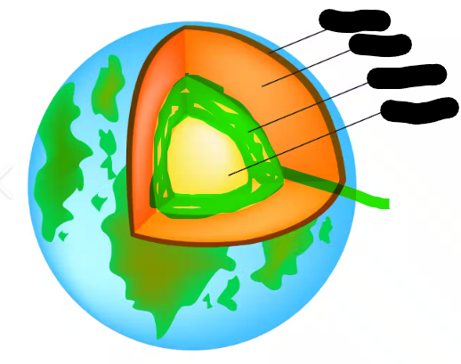
crust temperature, composition and thickness
25 degrees, solid rock, 30-50km thick
mantle temperature, composition and thickness
1000-3700 degrees, solid rock, 2,900km thick
outer core temperature, composition and thickness
4000-6000 degrees, liquid iron and nickel, 2,200km thick
inner core temperature, composition and thickness
5000-6000 degrees, solid iron and nickel, 1250km thick
Oceanic crust
below the ocean, on the sea floor, made of young igneous rock (less than 200 mill), denser than continental crust, average of 6km thin
Continental crust
above the ocean, on earth, made of old sedimentary, metamorphic and igneous rock, (more than 4.4 bill), less denser than oceanic crust, average of 40km thick
state the continental drift theory
A supercontinent called Pangaea broke apart into pieces which drifted away from each other over the past 220 million years forming the continents we have today.
5 pieces of evidence that supports the theory
shape of continents fit together, fossil evidence, rock evidence, glacial scars, coal deposits
describe the evidence, ‘shape of continents fit together’
The continents seem to fit together like a jigsaw puzzle.
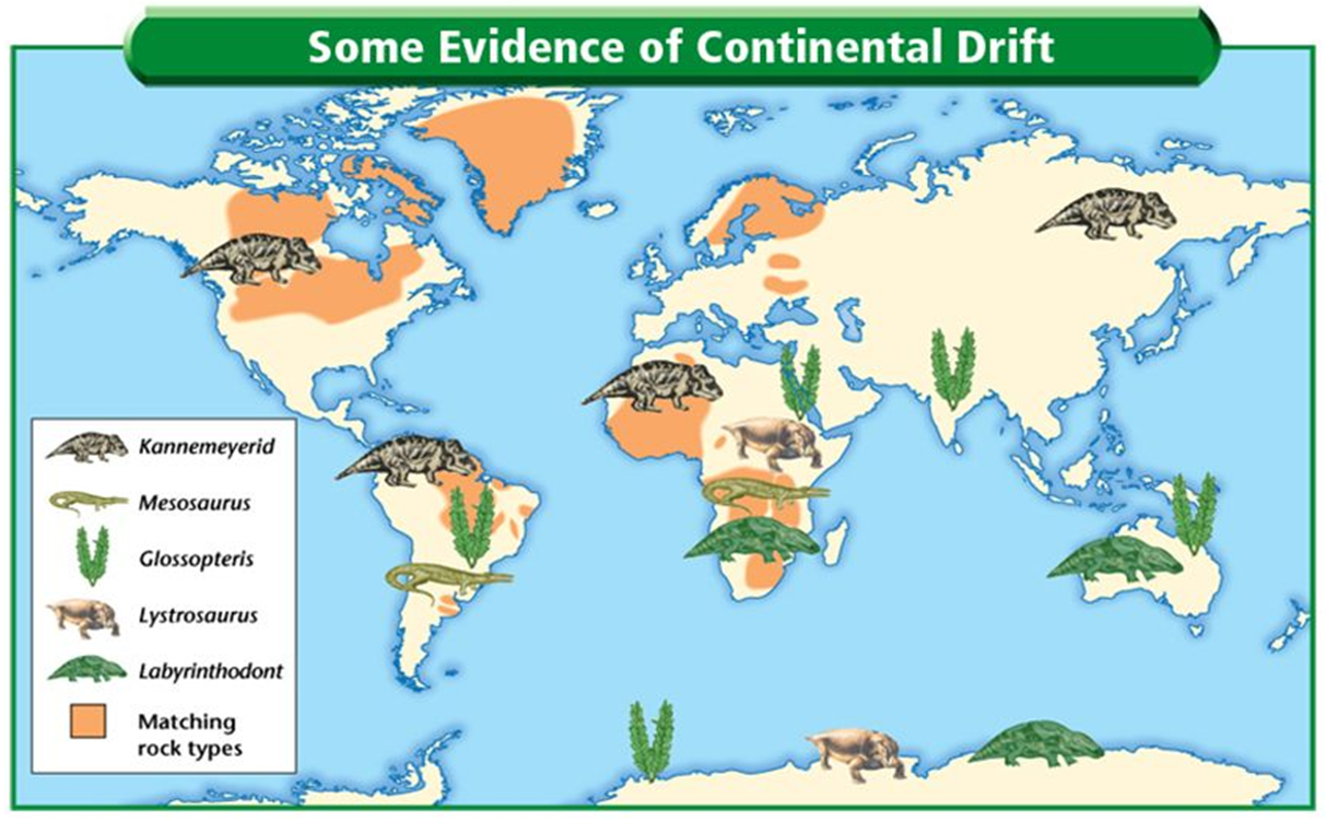
describe the evidence, ‘fossil evidence’
Fossils of the same organisms (that cant swim!) have been found on different continents.
describe the evidence, ‘rock evidence’
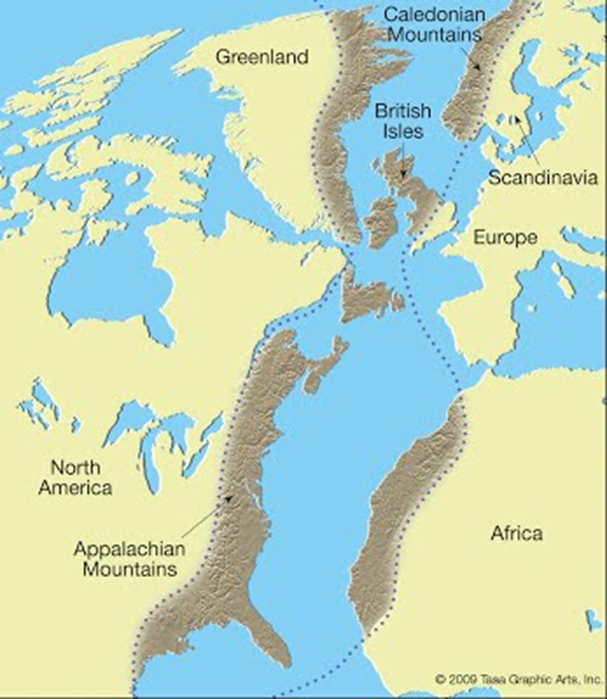
Many mountain ranges that are separated by vast oceans contain rocks of the same type and age.
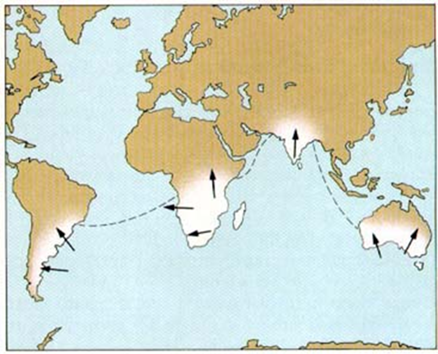
describe the evidence, ‘glacial scars’
Sometimes these glaciers pick up rocks, which leave deep scratches (‘scars’) in the bedrock as they move along. They have been found in India, Australia and Africa, places that are too warm to have glaciers.
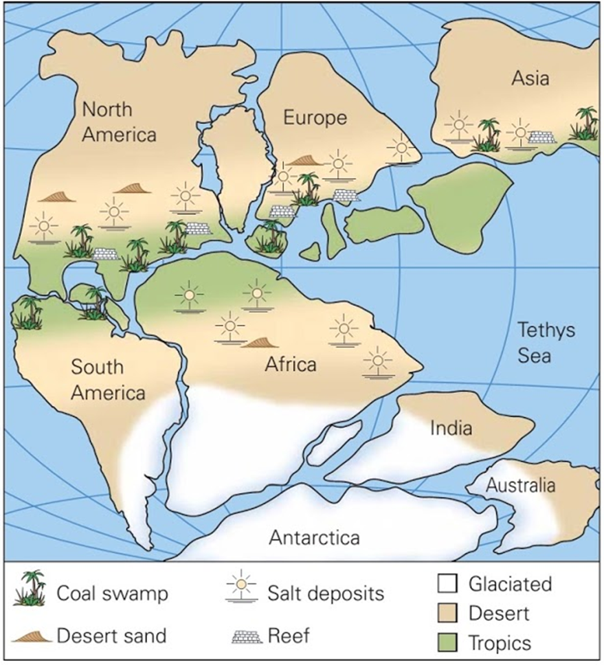
describe the evidence, ‘coal deposits’
Coal deposits were formed millions of years ago in hot tropical areas around the equator. However, in recent times, coal deposits have been found in polar regions such as Siberia.
Explain the evidence, ‘shape of continents fit together’
This suggests that the continents used to be next to each other.
Explain the evidence, ‘fossil evidence’
These fossils belong to large dinosaurs and fresh water plants that could not have crossed massive oceans.
This suggests that the continents used to be next to each other, allowing the organisms to travel by land.
Explain the evidence, ‘rock evidence’
This suggests that they formed as a single mountain
range which was broken in two as the continents drifted.
Explain the evidence, ‘glacial scars’
Matching scars have been found on different continents, suggesting that they were once joined up around the South Pole.
Explain the evidence, ‘coal deposits’
They could not have formed in the cold weather these areas currently experience, showing that the land mass must have previously been closer to the equator.
identify the type of evidence for continental drift using this model.
The evidence in this image is rock evidence.
This evidence suggests that since mountain ranges on different continents share identical rock layers, they used to be joined.
identify the type of evidence for continental drift using this model.
The evidence in this image is fossil evidence.
This evidence suggests that since the same fossils were found on different continents and they can’t swim, the land used to be joined.
identify the type of evidence for continental drift using this model.
The evidence in this image is glacial scars.
This evidence suggests that matching scars have been found on different continents, showing the continents used to be joined as a large glacier.
identify the type of evidence for continental drift using this model.
The evidence in this image is coal deposits.
This evidence suggests that the land mass must have previously been closer to the equator. as they could not have formed in the cold weather these areas currently experience.
The evidence in this image can also is continent shape
This evidence suggests that the continents used to be next to each other.
Name the scientist who proposed sea floor spreading
Harry Hess
Discuss why Wegener’s theory was rejected at first, consider the features that Wegener did or did not explain
Wegener did not explain how continents drifted and the mechanisms to suggest this.
Describe how scientists used SONAR to explore the sea floor
Scientists used SONAR (Sound Navigation and Ranging) to explore the sea floor by sending sound waves from a ship down to the ocean floor. When these sound waves hit the sea floor, they bounce back to the ship. Allowing scientists to measure.
Hess was in charge of an assault ship that used SONAR, to create images of the seafloor, to make a detailed map of parts of the Pacific ocean.
state the theory of sea floor spreading
magma erupts from the mantle into the ocean floor, creating new rocks and pushing old rocks to spread out and into the mantle to be recycled
Explain the process of sea floor spreading
Magma erupts from mid ocean ridge and cools to form new oceanic crust which spreads away from the ridge.
state the evidence for sea floor spreading
1.Rock shapes at mid-ocean ridges
2.Magnetic striping
3.Age of rock samples
describe and explain the evidence ‘Rock shapes at mid-ocean ridges’
pillow shaped rocks can be found, this shows molten material bubbled up from cracks along the centre of mid ocean rifts.
describe and explain the evidence ‘magnetic striping‘
scientists discovered zebralike patterns on the ocean floor when looking at magnetic strikes on rocks due to pole change. Matching patterns of stripes on each slide of ridges show each section of rock was at the same time as the mid ocean ridge it was found nearest to.
describe and explain the evidence ‘age of rock samples’
scientists found younger rocks where always in the middle of ridges, the further away from the ridge, the older they where. Older rocks spread out as new rocks formed
state the theory of plate tectonics
Earth’s crust and upper mantle is divided in fragments called tectonic plates that move continually over the mantle an average of 1-5cm a year, the large scale movement of tectonic plates that cause the formation of mountains, volcanoes and earthquakes.
identify the locations of earth’s major tectonic plates
African Plate
Underlies Africa
Antarctic Plate
Contains Antarctica
Australian Plate
Separated from Indo-Australian and contains Australia
Pacific Plate
Largest oceanic plate
Eurasian plate
Includes Eurasia
North American plate
Covers North America
South American plate
Includes South America
identify the types of plate boundary interactions
convergent- destructive , divergent- constructive, transform- neither constructive nor destructive
analyse trends with plate boundaries and volcano formations
edges of plates are plate boundaries where events like volcanoes occur, specifically at subduction at convergent boundaries.
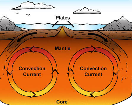
Describe the physical process of convection (Its like a kettle)
convection is the movement within a fluid where hotter less dense fluid rises up and colder and denser fluid sinks. When core heats mantle rock, it slowly becomes less dense and rises upwards, rising mantle rock hits the underside of the tectonic plate with it. rock cools and becomes more dense and continues to sink to be heated again.
if you could draw it, how would convection currents inside the Earth look like?
a repetitive circle under the plates in the mantle
Justify why convection currents might not be the only reason that tectonic plates move (slab pull/ Ridge Push)
while convection currents create the necessary heat flow and movement within the mantle, slab pull and ridge push are thought to be the major factors.
Slab Pull occurs when a dense oceanic plate sinks into the mantle. The edge of the plate is pulled down by its own weight. Ridge Push is created at mid-ocean ridges. The buoyancy of the newly created crust pushes the older crust away from the ridge, aiding in the movement of tectonic plates.
Define the features of an earthquake
the focus is a point within the earth where the energy is released while the epicentre is directly above the focus where energy reaches the surface
Explain how scientists measure the size of earthquakes
Scientists measure the magnitude of earthquakes using a seismogram. Seismograms produce a seismograph which is the visual record of earthquakes
Explain why some countries experience earthquakes more than others
earthquakes more commonly occur at transform boundaries where pressure builds up between them. Some countries are closer to these boundaries than others and therefore experience more earthquakes than others.
Define tsunami
a series of large waves caused by large scale disturbances such as earthquakes, volcanic eruptions, landslides, explosions or meteorites
Explain how tsunamis are formed (three steps)
1) the sudden upwards or downward movement of water displaces water above sea floor.
2) forms series of large waves that radiate in all directions
3) when tsunamis enter shallower waters, their energy is held by smaller volumes of water, so the wave height increases. In open ocean, their energy is held by a larger volume of water, so the wave height is smaller
its faster in small waves and slower in large waves
describe the impacts caused by tsunami’s events
loss of life and people loosing their homes, damage to infrastructure and farms, and environmental issues such as contamination of fresh water with salt water
Define the term volcano
a cone shaped mountain with a crater at the top and opens down into a magma chamber
Identify and describe the key features of a volcano
crater at the top, volcanic cloud of smoke, secondary vent that opens on the side, cone shaped body, magma chamber, main vent, flowing lava down the side, volcanic bomb made from rock thrown from volcano.
Explain the different stages of volcano activity
active will erupt frequently.
dormant may erupt.
extinct will not erupt, inactive.
Relate the shape of a volcano to the viscosity of the lava
low viscosity is flowing lava that flows a great distance and gives gently sloping cone shape.
High viscosity flows slowly and is thick, creating a steep sloping cone shape
Outline at least two ways volcanoes can cause damage
volcanic ash contains small glass like particles that rain down from volcanoes, can damage lungs.
Houses and buildings may collapse under weight and people and animals may die of suffocation
Relate plate boundaries to the location of volcanoes around the world
Volcanoes are found at subduction of convergent boundaries, not to mention the pacific ring of fire which is a tectonic belt of volcanoes where 75% f the world’s volcanoes lie as a result of the movement of tectonic plates.
HOTSPOTS
Hot pockets of molten rock called magma plume deep within the earth's mantle rises and weakens the overlying crust, causing volcanic islands or seamounts (underwater volcanos)
As tectonic plates move, the volcanic island moves away from the hotspot.The hotspot then forms new volcanos to replace the old volcanic island, creating a chain of volcanos. The further away a volcano is from the