Section C: Physical landscapes in the UK
1/206
There's no tags or description
Looks like no tags are added yet.
Name | Mastery | Learn | Test | Matching | Spaced | Call with Kai |
|---|
No analytics yet
Send a link to your students to track their progress
207 Terms
what is a landscape
an area's character that comes from the actions and interactions of natural and human elements
what does the character of a landscape depend on
-initial geology= this geology shapes the landscape’s relief, which then attracts human action and interaction
in the Uk, where are the uplands mostly found
The uplands are mainly in the north and west of the country, including Northern Ireland, Scotland, Wales, and northern England, such as the Lake District, Grampian Mountains, and Snowdonia
where are the lowland areas found in the UK
The lowlands lie in the south and east of the UK, including central and southern England, such as the Cotswolds, Norfolk, and South Downs
where do many cities sit
Many cities sit in lowland areas and often along major river routes, like Liverpool on the Mersey, Bristol on the Severn estuary, and the River Avon
Which one of these terms would you be more likely to use for an upland landscape than a lowland one?
[1 mark]
| A | Undulating |
| B | Rugged |
| C | Fertile |
| D | Gentle |
B
what is the coast
The meeting point between land and sea
what are the two parts that coastal processes are divided into
Marine processes: offshore (water-based)
Terrestrial processes: onshore (land-based)
what are waves
Waves are marine processes that
erode
transport
deposit
how are waves formed
are formed as winds blow over the surface of the sea
what are the 3 factors that the height and strength of the wave is dependent on
-the fetch
-the amount of time the wind blows
-the strength of the wind
when will the wave be the largest
the greater the strength, time and fetch of the wind the larger the wave
what happens when the wave enters the shallow water of the coast
as a wave enters shallow water of the coast, friction from the seabed causes the wave to lean forward and eventually crest and break onto the beach
-swash
-backwash
the movement of water up the beach
-the return movement
2 types of waves
-destructive waves erode the beach
-constructive waves are beach builders
constructive waves
-strong swash
-weak backwash
-wavelength is long with a low height
-low frequency
-forms depositional sandy beaches
destructive waves
-weak swash
-strong backwash
-short wavelength with high height
-high frequency
-forms erosional shingle beaches
Identify which statement below best describes the characteristics of a destructive wave?
| A | long wavelength and weak backwash |
| B | short wavelength and weak backwash |
| C | short wavelength and strong backwash |
| D | long wavelength and strong backwash |
[1 mark]
The answer is C [1]:
A destructive wave has a short wavelength, high frequency rate, steep wave gradient and a strong backwash
what does weathering mean
The break-down of rock in-situ ( in the original place)
what is the difference between weathering and erosion
weathering does not involve the movement of the material
sub-aerial weathering
describes coastal processes that are not linked to the action of the sea and includes freeze-thaw weathering and chemical weathering
what does weathering do to cliffs
weakens cliffs and makes them more vulnerable to erosion
freeze-thaw weathering
-water enters cracks in the rocks
-when temp drops to 0 or below, the water in the crack freezes forming ice
-water expands as it freezes creating huge forces on the surrounding areas of the rock
-these acting forces makes the cracks in the rock bigger
-when the temp rises again, the frozen water thaws
-this cycle of freezing and thawing occurs many time, until eventually a fragment of the rock breaks away completely
chemical weathering
When a chemical process breaks down rocks,
example of chemical weathering
rainwater will absorb co2 from atmosphere making it slightly acidic
this will interact with minerals in the rock and forms new material
biological weathering
when living things wear away rocks
example of biological weathering
-trees and other plants grow in the cracks of a rock formaton
-the root grow bigger and push open cracks in the rocks making them wider and deeper
-the growing tree forces the rock apart over time
Burrowing animals like rabbits disturb the ground above their burrows
This disturbance puts pressure on cracks, causing pieces of rock to fall off
what is mass movement
The downhill movement of material under the influence of gravity
slump
-typically located on weaker rock types that get saturated and heavy
-often occurs at the coast and is called rotational slip
-a large area of land moves down the slope in one piece
-it slumps and leaves a curved indented surface
fall
-slope rise sharply and movement happens quickly
Several reasons caused this.
Extreme weathering: Freeze-thaw action loosens rocks, making them unstable and causing collapse
Excess rain will soften the surface and cause the slope to collapse
Earthquakes dislodge unstable rocks
Hot weather dries out soil, causing it to shrink and rocks to fall
slide
A mass of material moves together until it reaches the bottom of a slope
Worked Example
Outline two ways that sub-aerial processes can affect the shape of a cliff
[4 marks]
Freeze-thaw weathering occurs when temperatures rise above and fall below freezing at 0°C. Water trapped in cracks of a rock freezes and expands, putting pressure on the crack. As temperatures rise, water melts, pressure releases, and the crack contracts. Repeated cycles break the rock apart over time. [U] More freeze-thaw happens in winter than in summer, leading to more weathering of the cliff face, making the cliff weaker. [K]
With chemical weathering, the rock type determines how quickly the rock dissolves. Rainwater and seawater are slightly acidic. Limestone reacts with the acid in water faster than granite because it is less resistant. [U] A cliff made of softer, less resistant limestone rock will weather faster and become more unstable faster than a cliff made of harder, more resistant granite rock. [K]
Marking guidance
Provide the main characteristics that explain briefly how each weathering process affects the shape of a cliff.
Mark allocation
This is a 'level of response' answer. Each point made in the answer does not equal a mark.
2 marks for knowledge [U] of a sub-aerial process.
2 marks for applying [Ap] that knowledge to determine the effects on a cliff.
Alternative content
The answer above is just one example of a response to this question. Other information that could be used in the answer includes:
Biological weathering
what is responsible for most of the erosion that happens along a coast
Destructive waves are responsible for the majority of erosion that happens along a coast
4 types of erosion
-hydraulic power/action
-attrition
-abrasion
-solution
hydraulic action
the sheer force of the waves hitting the coast
attrition
materials are carried by the waves and bump against each other and are worn smaller and smoother -forms shingles and sand and doesn't really erode the coast
solution
water which is slightly acidic dissolves the rock
what are some sources where materials in the sea arrive from
Eroded from cliffs
Transported by longshore drift along the coastline
Brought inland from offshore by constructive waves
Carried to the coastline by a river
once in the water, what are the 4 ways in which the material is moved
-traction
-saltation
-suspension
-solution
traction
is where large heavy material is dragged along the sea floor
saltation
is where smaller materials is bounced across the sea floor
suspension
is where fine materials is held in the water
solution
is dissolved material carried in the water
Longshore drift
This is the main process of deposition and transportation along the coast
Waves approach the beach at an angle due to the prevailing wind
As the waves break, the swash carries material up the beach at the same angle
As the swash dies away, the backwash carries the material down the beach at right angles (90°)
The process repeats, transporting material along the beach in a zig-zag movement
Worked Example
Describe and explain the process of longshore drift
[4 marks]
Longshore drift is the process where the waves transport material, [K] such as sand, along the beach in the direction of the prevailing wind. [K] The swash moves material up the beach at an angle as the waves approach in a similar direction to the wind. [U] The material backwashes down the beach at 90° due to gravity. This movement continues along the beach in a zigzag motion. U]
Marking guidance
Your focus is 'longshore drift'—what is it and how does it work?
Mark allocation
This is a 'level of response' answer. Each point made in the answer does not equal a mark.
2 marks for knowledge. [K]
2 marks for understanding. [U]
The command is describe and explain and answers should identify longshore drift as the method of transporting material along a beach and explain how that happens
Deposition
Deposition occurs when material is dropped from seawater
This happens when the water flow's speed (velocity) decreases
This means the force is no longer strong enough to keep the material suspended in the water, so it drops to the ground
where does sediment deposits
in bays to form beaches
where do salt marshes and mudflats form
in sheltered estuaries typically behind spits
Worked Example
Study Figure 9, a photograph taken along the stretch of coastline.

Suggest one type of mass movement that is affecting these cliffs.
[1 mark]
Answer:
Rock fall [1 mark]
Marking guidance
The question asks about mass movement and not weathering; therefore, your answer should reflect this.
Alternative content
The answer above is just one example of a response to this question. Other information that could be used in the answer includes:
Slumping
Landslip
Landslide
erosion of softer rocks like sand and clays along a coastline
erode easily due to destructive waves, creating low flat landscape like bays and beaches
erosion of harder rock
coastline with harder rock erode slowly and create rugged landscapes like headlands
how does hard rock affect the coastline
shape of the cliff= usually high and steep
cliff face= has bare rock and rugged outcrops
foot of cliff= has boulders and rocks at the base
how does soft rock affect the coastline
shape of cliff= cliff face is lower and less steep
cliff face=is smoother with evidence of slumping
foot of cliff=there are few rocks at the base and usually there is some sand and mud
how do headland and bays form
These happen where hard and soft rocks alternate and run perpendicular to incoming waves
The softer rock, like clay, erodes backward and forms an inlet
The inlet erodes and curves inwards, forming a bay, often with a beach
More resistant rock, such as granite, sticks out into the sea as a headland
characteristics of a headland
Projects out to sea
Is longer than it is wide
Has a geology of resistant rock
Cliffs lining its sides
characteristics of a bay
A wide, open entrance from the sea
A roughly semi-circular shape that extends into the coastline
Land that is lower than the headlands surrounding it
A bay may or may not have a beach
cliffs
Cliffs are shaped through erosion and weathering processes
Soft rock erodes quickly and will form sloping cliff faces
Steep cliffs are formed where there is hard rock facing the sea
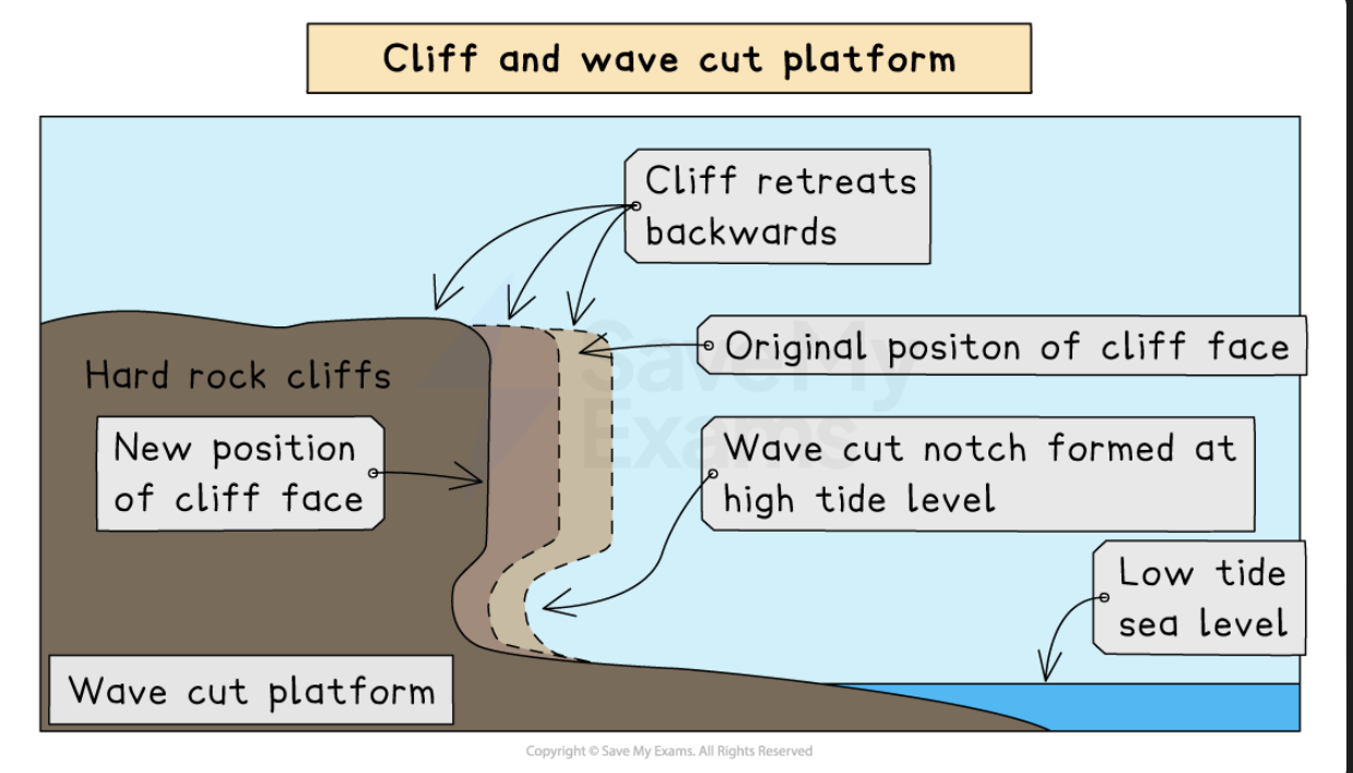
wave cut platforms
These are wide, gently sloped surfaces found at the foot of a cliff
The sea hits the base of a cliff between the high and low water mark, forming a wave-cut notch
Abrasion, corrosion, and hydraulic action push the notch deeper into the cliff
The cliff becomes unstable and collapses when it is undercut
The waves wash away the eroded material, creating a wave-cut platform
The process repeats, and coastal retreat occurs as the cliff keeps moving backwards
how are caves formed
-waves slow down as they reach the shore and move along the sea floor
-the angle of the waves changes and turns making the crest parallel to the coast. this is called wave refraction
-this refraction focuses erosion on every side of the headland
-hydraulic power, abrasion and some corrosion start attack weaknesses in the headland
-the crack widens and abrasion wears away at the forming cave
how are arches formed
continued wave action means that the cave grows larger and eventually breaks through the headland to form an arch
how are stacks formed
the base of the arch gets wider and thinner due to erosion below and weathering from above. the roof of the arch collapses, leaving an isolated column of rock called a stack
how are stumps formed
wave action and weathering undercut the base of the stack until it collapses leaving a stump
how are beaches formed
-Form in sheltered areas such as bays through deposition via constructive wave movement, where the swash is stronger than the backwash
-When a constructive wave carries sediment up the beach, the largest material is deposited along the upper reach of the swash
-As the backwash moves back down the beach, it loses water and therefore energy as it travels due to the porosity of the sand
-Consequently, the deposition of sediment gets progressively smaller, and the beach is therefore sorted by wave deposition, with the smallest mud particles settling in the low-energy environment offshore
-If a destructive wave forms due to a storm, then large shingle is thrown above the usual high tide level to form a ridge at the top of the beach called a berm
sand dunes
-Blown sand can create sand dunes at the backshore of a beach
what type of environment are sand dunes
dynamic means that ever changing and does not stay the same
where do sandy beaches usually have sand dunes
Sandy beaches usually have sand dunes at their rear because of strong onshore winds transporting dried, exposed sand
how are embryo dunes formed
Sand grains are trapped and deposited against any obstacle (rubbish, rocks, driftwood, etc.) and begin to form embryo dunes
sand dune formation
The wind blows deposited sand up the beach. Objects like wood, driftwood or human rubbish can block the wind, leading to hills of sand. The hills of sand can allow plants and vegetation to grow.
An obstruction deposits windblown sand against it. Pebble or driftwood
As more sand particles are caught, the dunes grow in size, forming rows at right angles to the prevailing wind
Over time, the ridges of the dunes will be colonized and fixed by vegetation in a process called succession
The first plants, known as pioneer species, must cope with the following challenges:
Salinity
Lack of moisture as sand drains quickly (highly permeable)
Wind
Temporary submergence by wind-blown sand
Rising sea levels
embryo dunes
Wind-blown dried sand is trapped by debris and deposition begins
Pioneer species such as Lyme Grass and Sea Couch Grass begin to colonise
There is little soil content and high pH levels (alkaline)
Embryo dunes are very fragile and reach a maximum height of 1 metre
fore dunes
The embryo dunes bring some protection against the prevailing wind
This allows other species of plant to grow, such as Marram Grass
Marram grass begins to stabilise the dune with its root system
These plants add organic matter to the dunes, making the dunes more hospitable for plants that later grow
A microclimate forms in the dune slack
Maximum height is 5 metres
yellow dunes
These are initially yellow but darken as organic material adds humus to the soil
Marram grass still dominates the vegetation, but more delicate flowering plants and insects are found in the dune slacks
20% of the dune is exposed, down from 80%
Height does not exceed 8 metres
grey dunes
Grey dunes are more stable, with less than 10% of exposed sand and have a good range of biodiversitySoil acidity and water content increase as more humus is added
Shrubs and bushes begin to appear
Height is between 8 and 10 metres
mature dunes
As the name suggests, these are the oldest and most stable of the dunes
They are found several hundred metres or more from the shoreline
The soil can support a variety of flora and fauna, such as oak trees and alders (climax vegetation)
This is the final stage in succession, which is known as the climax community stage
what are spits
An extended stretch of sand or shingle that extends out to sea from the shore
Spits occur when there is a change in the shape of the coastline
Or the mouth of a river, which prevents a spit forming across the estuary
A spit may or may not have a 'hooked' end, depending on opposing winds and currents
stages of formation of a spit
Sediment is transported by the action of longshore drift
Where the coastline changes direction, a shallow, sheltered area allows for deposition of sediment
Due to increased friction, more deposition occurs
Eventually, a spit slowly builds up to sea level and extends in length
If the wind changes direction, then the wave pattern alters and results in a hooked end
The area behind the spit becomes sheltered
Silts are deposited here to form salt marshes or mud flats

bars
When a spit grows across a bay and joins two headlands together
A bar of sand is formed (sandbar)
Sandbars can also form offshore due to the action of breaking waves from a beach

Worked Example
Figures 3.1, 3.2, and 3.3 show three coastlines.

Identify each of the following landforms:
(i)
landform W in Fig. 3.1
[1 mark]
(ii)
landform X in Fig. 3.2
[1 mark]
(iii)
landform Y in Fig. 3.2
[1 mark]
(iv)
landform Z in Fig. 3.3.
[1 mark]
Answer:
W - Wave-cut platform [1]
X – Beach [1]
Y – Sand dunes [1]
Z - Cliff [1]
what has the geology of the Dorset coast perfect for
The geology of the Dorset coast is perfect for both erosional and depositional landforms
It has bands of soft clay and harder limestone and chalk
These rocks erode at different rates, creating headlands, bays, arches, a long tombolo and more
Durdle Door
Durdle Door is an example of an arch formationWave erosion opened a crack in the tough limestone headland
Further erosion led to a cave which developed into an arch in the headland
Softer rocks behind the limestone have been washed away, leaving an eroding line of chalk cliffs
Lulworth Cove
Lulworth Cove is a small bay that was formed when a gap was eroded in the band of tough limestone
Lying behind this limestone is a band of soft clay, and this has been scooped out (eroded away) to form a bay
The entrance to the cove is narrow because the harder band of limestone is more resistant to erosion
Swanage
Swanage sits on two beach bays called Studland Bay and Swanage Bay
These are areas of soft sandstone and clay
Between the two bays is The Foreland, a headland of harder chalk
Old Harry
Old Harry and his wife sit at the end of The ForelandThe chalk headland has eroded to form caves, arches and a stack (Old Harry)
Further erosion has resulted in a stump called Old Harry's Wife
Chisel beach
Chesil Beach is an 18-mile-long pebble tombolo
Formed through the process of longshore drift, it joins the Isle of Portland to the mainland
There is a shallow lagoon behind the tombolo called The Fleet Lagoon
coastal management
Coastal management aims to protect the environment and people from erosion and flooding
why can some coastal areas cannot get protection
Coastal management aims to protect the environment and people from erosion and flooding
hard engineering methods
ard engineering builds sea defences using materials like concrete, wood, or rock
Construction is expensive, and they need regular maintenance
Defences protect against the waves' power
Every type of defence has strengths and weaknesses, such as:
Protecting one area can affect other regions along the coast, leading to increased erosion and flooding
Hard engineering is used when settlements and expensive installations, like power stations, are at risk because the economic benefit exceeds the costs of construction
what are examples of hard engineering defences
sea walls, rock armour, gabions and groynes
sea wall
These are usually built from concrete and curved outward to reflect the waves' power back out to sea
advantage of sea wall
Advantages
Most effective at preventing both erosion and flooding (if the wall is high enough)
disadvantage of sea wall
Disadvantages
Very expensive to build and maintain
It can be damaged if the material in front of the wall is not maintained
It can restrict access to the beach
Unsightly to look at
groynes
Wood, rock or steel piling built at right angles to the shore, which traps beach material being moved by longshore drift
advantage of groynes
Advantages
Slows down beach erosion
Creates wider beaches
disadvantages of groynes
Disadvantages
Beaches along the coast are deprived of sand
Wooden groynes need to be maintained to prevent wood rot
Walking along the shoreline is difficult
Off-shore barriers
Large concrete blocks, rocks and boulders are sunk offshore to alter wave direction and dissipate wave energy
Advantages of off-shore barriers
Effective at breaking wave energy before reaching the shore
Beach material is built up
Low maintenance
Maintains natural beach appearance
disadvantages of off-shore
Expensive to build
Can be removed in heavy storms
Can be unattractive
Prevents surfing and sailing
Rip-rap or rock armour
Large boulders are piled up to protect a stretch of coast
advantages of rip-rap
Cheaper method of construction
Works to absorb wave energy from the base of cliffs and sea walls
disadvantage of rip-rap
Boulders can be eroded or dislodged during heavy storms
gabions
A wall of wire cages filled with stone, concrete, sand, etc., built at the foot of cliffs