Edexcel A Level Geography - Water Cycle
1/79
There's no tags or description
Looks like no tags are added yet.
Name | Mastery | Learn | Test | Matching | Spaced |
|---|
No study sessions yet.
80 Terms
what is the hydrological cycle known as
a system comprised of
stores - the holding of water
flows - measure the rate of flow between stores
processes - physical factors that drive the water
what drives the hydrological cycle
Solar energy and gravitational potential energy
what is the global water budget
the annual balance of water flows and the size of the water stores
what is residence time
the average time a water molecule will spend in a reservoir or store
how much percent of the earths water is stored in the ocean
97%
what is a drainage basin
an area of land drained by a river and its tributaries
what is a watershed boundary
an area of land that separates water flowing to different rivers
what is the ITCZ
inter tropical convergence zone, it is a low pressure belt encircling the Earth, near the equator, it moves and impacts precipitation
the 3 cells around the earth giving different temperatures at different latitudes
polar - 60-90 degree
ferrel - 30-60 degree
hadley - 0-30 degree
what is convectional rainfall
Due to heating by the sun, warm air rises, condenses at higher altitudes and falls as rain
what is orographic rainfall
caused by uplifting and cooling of moist air over mountains
what is frontal rainfall
when a warm air mass meets a cold air mass, forcing the warmer air to rise and cool over the denser air
The UK's rainfall
the tees- exe line separates the rainfall of the UK, with orographic rainfall mainly happens in the west, and convectional in the south, but over a year, frontal rainfall brings the most to the whole UK
how does deforestation affect the drainage basin
reduces evapotranspiration, less ground water to aid in dry days, rainwater runs quickly, flooding
3 human factors affecting a drainage basin
deforestation, urbanisation reservoirs
how does urbanisation affect a drainage basin
buildings have far more run off than nature at 55% to 10%, and far less infiltration and deep infiltration
how does reservoirs affect a drainage basin
they are man made, that interrupt the flow of water, reduce river flow, e.g Kenya tana river flood plain forest is dying lack of floods upstream
what physical factors affect a drainage basin
vegetation cover
temperature
geology
soil type
what is the only input to a drainage basin
precipitation
what physical factors affect the Thames river basin, UK
annual precipitation - 600-750mm/year
soil/rock type - sedimentary rocks
what human factors affect the Thames river basin, UK
land use - urban, agriculture, transport
pollution - sewage run off
flood risk
Thames barrier - for tidal flood control
population pressure - 15million+ in basin
what physical factors affect the toncantis river
Tropical climate - 2000 + mm/year
dense rainforest, allows for high interception and evapotranspiration
what human factors affect the toncantis river
Tucurui Dam one of the worlds largest, alter river flow and increase flood risk
deforestation increases run off
agriculture near the river, pollutes river, reduces interception
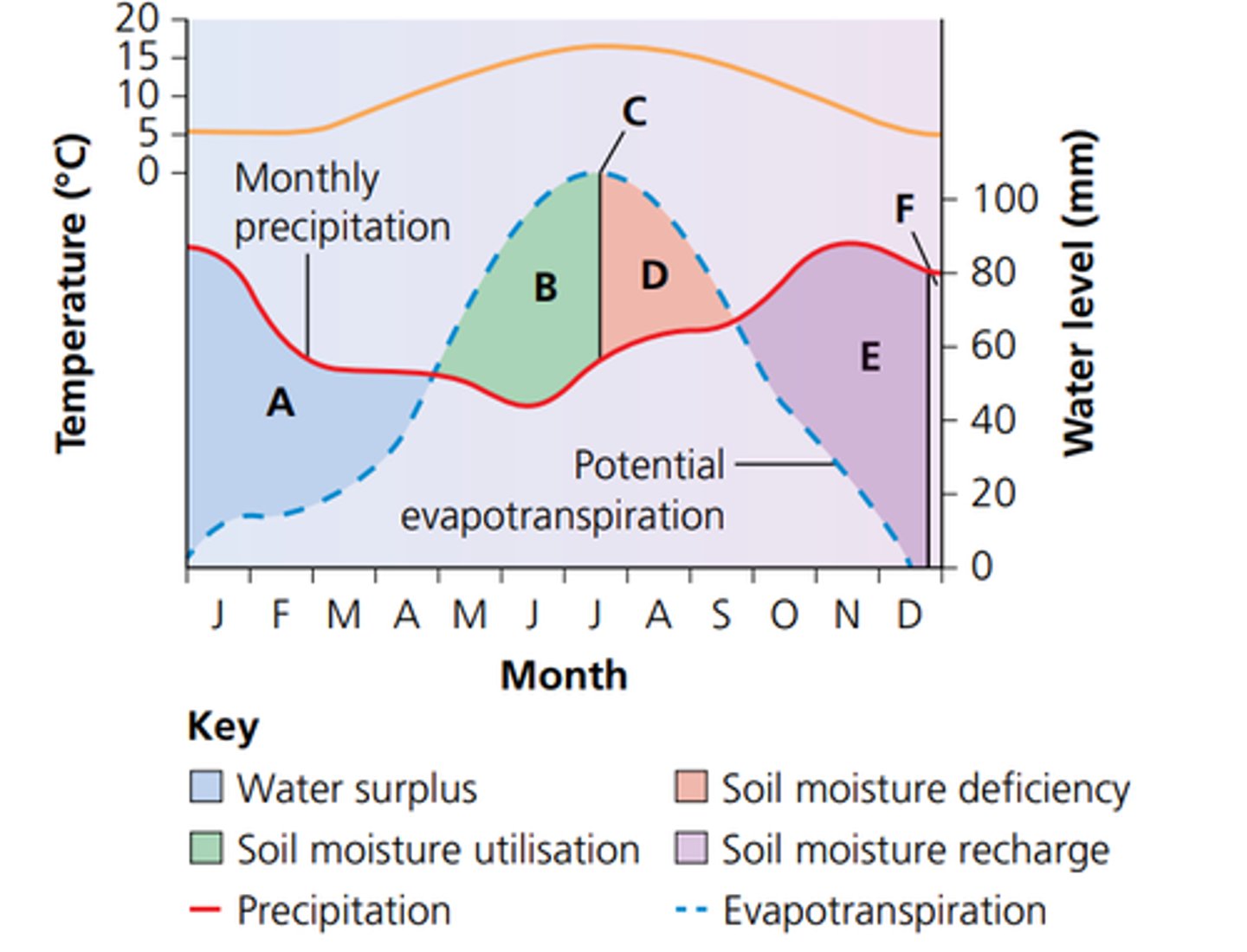
what is the water budget
show the annual balance between inputs and outputs
What does the water budget graph show
what is precipitation
rain, snow, sleet, or hail that falls to the ground.
what is interception
A temporary storage whereby water is captured by plants and buildings before reaching the ground.
what is surface storage
water in lakes, ponds, puddles
what is ground water storage
water held within permeable rocks
what is percolation
When water moves vertically down through soil and rock
what is evapotranspiration
the combined effect of evaporation and transpiration
what is river discharge
The volume of water passing a measuring point in a given time.
what is a river regime
the difference in the discharge of the river throughout the year
what is a simple regime
One where a river has a period of seasonally high discharge (glacier melt, monsoons), followed by low discharge.
what is a complex regime
One that is affected by many variables because they are larger and cross several relief and climatic zones. they are affected by human factors
River Yukon - Alaska - regime
complex, low discharge until may, snow melt contribute to rising river levels, peak discharge in june of 16000, then starts to drop after june until winter months and refreeze
River Amazon - West of South America to east - regime
complex, peak rainfall in feb/march direct sunlight (270mm), peak discharge in june despite rain at lowest, due to large basin + all tributaries to reach, fall in convectional rainfall june-oct, tilt from sun
what is a flashy river
a river with a short lag time, fast flow, impermeable surface
what is a flat river
a river with a long lag time
what is a storm hydrograph
a graph that shows changes in discharge of a river over a short period of time
4 types of drought
meteorological - precipitation is below average
agricultural - lack of growth due to no rain
hydrological - lack of water supplies in streams
socioeconomic - the impact on the population
River Severn case study
longest river in the uk 354km, flow through wales, west england, regime seasonal variation, flow high in winter/spring due to rainfall/snowmelt
River Severn case study human impacts and the flood management
Human
building on floodplain
agricultural land
flood management
hard engineering in gloucester e.g levee/embankment
Mississippi River USA
One of the longest rivers in the world 3730km, from north usa to gulf of mexico
river regime - high variety, heavy rain in summer, snowmelt in spring peak, large drainage basin
Mississippi River USA human impact and flood management
human impact
loss of wetlands - natural storage reduced
flood management
river engineering - levee spilways
what is a anti cyclone
areas that experience intense high pressure and sinking air, pressure of 1008mb
What does ENSO stand for
El Nino Southern Oscillation
What is the ENSO cycle, where does it happen between
Movement of warm water mass in the equatorial Pacific Ocean
Australia to south America
what is the 'normal condition' in the pacific ocean
Warm water by Australia and east Aisa, causing warm air to rise, lots of rain
Cold water by South America, air sinks, high pressure and no rain
What is La Nina
the process of intensifying normal conditions
What is El Nino
Weather patterns swap, heavy rainfall in S America, Droughts in Australia
What does over abstraction mean
the amount of water used has been too much and not enough has been replenished, leads to water scarcity.
what is a aquifer
body of permeable rock that can hold or transmit ground water.
what is a confined aquifer
covered by permeable rock deep down, hard for water to get to
what is a unconfined aquifer
a groundwater layer with no impermeable barrier above it.
impact of over abstraction
water reduce in layers
water quality falls
water table sinks
England water situation - drought 2025
water crisis caused by plant watering, over abstraction, heat caused water sources to dry up, will need mass rainfall to replenish as a dry year one year can cause be a threat if a drought happens next year, water tables significantly lower
how can humans increase drought risk
deforestation
over-abstraction
impact of deforestation on drought risk
deforestation = no evaporation = less rainfall = decrease in discharge
what does ecosystem functioning mean
the biological, physical and chemical processes that take place within an ecosystem.
impact of drought on forest
younger trees die, canopy cover reduces, exposing dry surface litter fire prone.
what caused the 2014-15 Brazil drought
anti cyclone blocking rain bearing winds away from the amazon, deforestation, less transpiration.
what impact did the Brazil 2014-15 drought have
reduced crop of arabica coffee beans - global coffee price up by 50%
groundwater extraction up - aquifers low
fall in HEP production -
What caused the 2019-20 Pantanal wetland drought
140,000km2. Anti cyclone caused high pressure. 192% increase in wildfires from 2019. ground litter exposed.
What impact did the 2019-20 Pantanal wetland drought have
40m reliant on the river. over 70,000 km 2 burned. agriculture and ecosystem suffers. Breathing issues from smoke. Burned trees, release co2, less transpiration. Exposed ground, heat up and cause lowering water tables, kill vegetation
what does surface water flooding mean
flooding that occurs when intense rainfall has not enough time to infiltrate the soil , flows overland
what does groundwater flooding mean
prolonged heavy rain, cause land to become saturated, as a result floods happen
what does flash flooding mean
high level of rain, short lag time flood
physical causes of flooding
amount and type of rainfall - influence intensity of rain
impermeable material
relief ( land angle )
human causes of flooding
urbanisation
deforestation
land use
infastructure
what physical and human factors caused the Texas flood keer county - 4-5th July 2025
physical - flash flood, 200mm + rain in hours, river rose 8m in 1 hour, steep terrain accelerated water
human - built on a vulnerable flood plain
impacts of the Texas flood keer county - 4-5th July 2025
130 deaths - 200 missing
poor land use planning, flash flood in HIC area
loss of habitats
what physical and human factors caused the Pakistan monsoon flood June-October 2022
physical - flash flood exacerbated by climate, monsoon rainfall and glacier melt from Himalayas mountain cause river indus over load
human - deforestation, poor land management
impacts of the Pakistan monsoon flood June-October 2022
33m+ displaced 1300 deaths
$15B loss
crops loss and submerged, food insecurity worsen
what physical and human factors caused the west Germany and east Belgium 12-15 July 2021 flood
physical - low pressure system, intense rainfall, 150mm over 24h, caused river ahr overload
human - climate change made this disaster 9x more likely to occur.
impacts of the west Germany and east Belgium 12-15 July 2021 flood
200 deaths
€30B loss in Germany alone
habitat loss
What physical and human factors caused the oxford Jan 2024 floods
physical - surface water flooding, storm Henk cause river Cherwell and Thames overflow, saturated soil, higher flood risk, more run off
human - impermeable surface, city expansion.
impacts of the oxford Jan 2024 floods
no deaths
road closure
city loss of businesses.
polluted water systems.
what physical and human factors caused the Nigeria July - October 2022 flood
physical - shift in ITCZ north, heavy rainfall in N, monsoon season
human - Cameroon lagdo dam overflow, flows into Benue river Nigeria and floods.
impacts of the Nigeria July - October flood 2022
600+ died, 1.3m displaced
food inflation rise
agriculture land flood, soil erosion, 50% water contaminated.