HYDROLOGY - MIDTERM
1/28
There's no tags or description
Looks like no tags are added yet.
Name | Mastery | Learn | Test | Matching | Spaced |
|---|
No study sessions yet.
29 Terms
hydrology
is a multidisciplinary subject that deals with the occurrence, circulation, storage and distribution of surface and ground water on the earth.
Hydrology is the study of water - its movement, distribution, and behavior on Earth. It helps us understand how rainfall becomes runoff, how rivers flow, and how water interacts with the soil and atmosphere.
What is Hydrology?
Weather is what we experience day to day - like when it’s sunny in the morning and rainy by afternoon.
Climate is the average behavior of weather over a long time. It describes what the weather is usually like in a region.
Explain the difference of weather and climate
The Hydrologic Cycle, also called the Water Cycle, is the continuous movement of water on, above, and below the surface of the Earth
1. Evaporation – Water from oceans, rivers, and other surfaces turns into vapor due to the sun’s heat and rises into the atmosphere.
2. Transpiration – Plants release water vapor from their leaves through small openings called stomata.
3. Condensation – Water vapor cools and changes into tiny droplets, forming clouds in the atmosphere.
4. Precipitation – When the droplets in clouds become heavy, they fall to the ground as rain, snow, or hail.
5. Infiltration – Part of the rainfall seeps into the soil and refills the groundwater or aquifers.
6. Runoff – The remaining water flows over the land surface into rivers, lakes, and oceans.
Explain the Hydrologic Cycle and its significance to the environment
hydrologic cycle
periods of water resources renewal on the earth
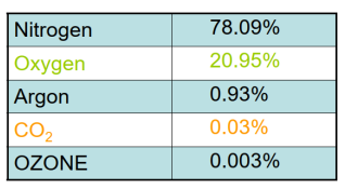
what are the volume in % of five gases in atmosphere?
air mass
is a large air body whose physical properties (temp, vapor, wind, and pressure) are constant in a horizontal plane
There are four main types of storms: convective, orographic, cyclonic, and tropical cyclones.
Convective storms occur when the sun heats the Earth’s surface, causing warm moist air to rise, cool, and condense into cumulonimbus clouds. These storms are short but intense, often producing heavy rain, lightning, and thunder.
Orographic storms happen when moist air is forced to rise over mountains.
Cyclonic storms form around low-pressure centers where air spirals inward and upward. They cover large areas and bring widespread rainfall and strong winds.
Tropical cyclones are powerful low-pressure systems that develop over warm oceans. They are classified as tropical depressions, storms, or typhoons depending on wind speed.
What are the four types of storm? explain each one
the maximum probable flood that may occur at a given site and its frequency; this is required for the safe design of drains and culverts, dams and reservoirs, channels and other flood control structures
The study of hydrology helps us to know:
watershed
is an important physiographic property that determines the volume of runoff to be expected from a given rainfall event that falls over the area.
A watershed is an area of land where all rainfall and surface runoff drain to a common outlet, like a river, lake, or sea.
Watersheds are essential in water management because they define the natural boundaries for monitoring water flow and quality. Engineers study them to design dams, reservoirs, and drainage systems that can handle rainfall safely.
Define a watershed and explain its role in water management
To delineate a watershed means to outline its boundary - the line that separates one drainage area from another. This is usually done by identifying the highest elevation points that direct water flow to a specific outlet.
Explain how to delineate a watershed
confluence
Point where two streams or rivers meet is called the ?
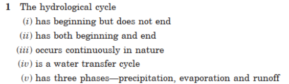
(i), (iii), (iv), and (v)
Choose the correct statement/s in the following:
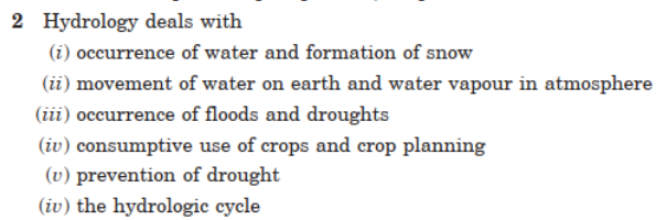
(i), (ii), (iii), (v), and (vi)
Choose the correct statement/s in the following:
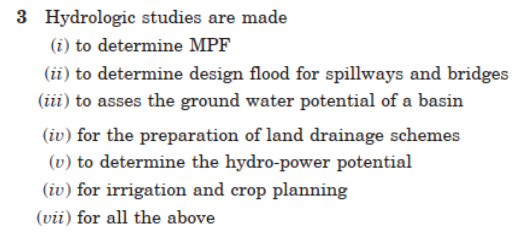
(vii)
Choose the correct statement/s in the following:

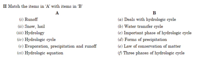
Match the items in “A” with items in “B”
Basic data needed include rainfall, streamflow, evaporation, infiltration, and temperature records.
In the Philippines, these can be obtained from agencies such as PAGASA , DPWH, and DENR. These data help engineers design flood control systems, reservoirs, and drainage plans based on real weather and hydrologic conditions.
What are the basic data required for hydrological studies? Name the agencies from which the data can be obtained.
Hydrology provides the scientific basis for planning, developing, and managing water resources. It helps determine the availability of water, design flood levels, and drainage needs in a basin.
For river basin development, basic hydrologic requirements include data on rainfall, runoff, infiltration capacity, soil characteristics, and evaporation rates.
What is the function of hydrology in water resources development? What are the basic hydrological requirements for a river basin development?
The hydrologic equation expresses the law of conservation of mass for a water system. It is written as: P= R + G + E ± ΔS
It shows that the total amount of water entering a system equals the amount leaving plus or minus the change in storage.
Explain ‘hydrologic equation’
precipitation
is considered as the main input in the hydrologic cycle.
atmosphere is saturated
small particles are present
drops are big enough to reach the surface
precipitation occurs when 3 conditions are met
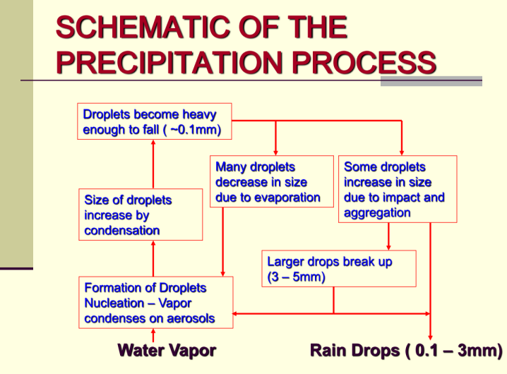
Draw the schematic of the precipitation process
use of rain gage (most common)
through radars
satellite data
3 ways in measuring rainfall data
Rainfall is measured using rain gauges.
Non-recording gauges measure total rainfall, while recording gauges provide continuous records of rainfall over time.
Rainfall data is then analyzed for its intensity, duration, and frequency to understand rainfall behavior in an area.
Explain how rainfall is measured and analyzed
interception loss
The precipitation intercepted by foliage (plant leaves, forests) and buildings and returned to atmosphere (by evaporation from plant leaves) without reaching the ground surface
Rationale
The peak runoff at the outlet of the watershed due a steady rainfall is obtained when the entire basin is contributing runoff at the outlet.
Time of Concentration
The time of travel of the water from the most remote part hydraulically of the catchment to the outlet of that catchment.
Time of Concentration (Tc)
Travelled time of stormwater from the farthest po int to the outlet.