Tornadoes and Floods
1/30
There's no tags or description
Looks like no tags are added yet.
Name | Mastery | Learn | Test | Matching | Spaced |
|---|
No study sessions yet.
31 Terms
Cold Waves and Polar Vortex
Cold wave: a relatively rapid, prolonged fall in temperature that requires people to take precautions against the cold
There is no standard criteria for this
Polar vortex: flow of cold air (a fluid) circulating around the North Pole
If mid-latitude cyclone occurs in N. America, the polar front under these conditions, can extend far to the south and may pass over the Gulf Coast into central Florida
This can last for days
Winter Storms Intensity
In the U.S., snowfall intensity depends on visibility
Light snow, when visibility is greater than 1km
Moderate snow, between 1km and 0.5km
Heavy snow, less than 0.5km
Winter Storms - Blizzards
Associated with snowstorms
National Weather Service (U.S)
Blizzards when winds exceed 56km/h and visibility less than ¼ mile for 3 hours
Ground blizzards extend 10-15 above the ground and can persists for hours. This is not new precipitation but movement of snow by wind
Winter Storms - Ice Storm
Ice Strom: a winter storm produced an accumulation of ice at the ground surface as a result prolonged freezing rain
In the winter, the 0C isotherm, the invisible boundary that separates warmer air (above freezing) from cooler air (below freezing), envelops a wedge or tongue of warmer air that crosses the warm front
The character of the precipitation that reaches the ground at a given location varies depending on the position of the location relative to this wave
Winter Storms - Ice Storm - Locations
Location A: now passes down across the 0C isotherm at an elevation of 0.5-1.5km and descends into warmer air, where it melts
Location B: falling rain crosses the 0C isotherm again, close to the ground. It then descends in coddler air, so raindrops become supercooled, meaning that they remain in liquid form, even though they are below freezing. These freeze on contact on a cold solid surface - freezing rain
Location C: the wedge of wamr air aloft is not as deep and its temperature, although above freezing is not as warm. Snow falling through the warm air wedge and the location melts only partially, and as it falls into cold airs, it refreezes
Frozen raindrops are called sleet or ice
Location D: snow call falls through cold air all the way to the ground
The ITCZ is visible as a band of clouds encircling Earth near the Equator
Tornados - Regina Tornado - June 30, 1912
Considered deadliest tornado in Canadian history (F4)
28 killed, 300 injured, ~2500 displaced
1.2 million CAD in damages ($30.5 million in 2022)
Tornadoes
Tornado Alley region in central U.S> and Canada associated with frequent tornadoes
Oklahoma, Kansas, Nebraska, South Dakota, Iowa, Minnesota, etc.
Research suggests that the main alley may be shifting eastward away from the Great Plain
Tornadoes are also becoming more frequent in the northern and eastern parts of Tornado Alley where it reaches the Canadian Praries, Ohio, michigan, and Southern Ontario
Scenario looks at tornadoes forming from SW to NE U.S.
A supercall thunderstorm wil contain a strong rotating updraft, called a mesocyclone, and that strong doendrafts form on both the forward (NE) flank and the rear (SW) flank of mesocyclone
Tornado development occurs in association with the rear-flank downdraft
As the rapidly downward-flowing air of this downdraft approaches the round, it spreads outward and produced a roll of rotating air near the ground along the downdraft’s speaking outer boundary
The air in this role spins around horizontal axis
A tornado forms when the part of the roll that passes under the base of the mesocyclone gets pulled upward into the mesocyclone
Initially, the roll warps into a tight arch, but the clockwise-rotating arm, rotating in the opposite direction of the larger mesocycone, quickly weakens and dissipates, while the counter clockwise-rotatinf arm, the rotating in the same direction as the meocyclone, gets carried into the updraft, where it stretches and narrows to become with the ground, it forms a tornado
If the spinning vortex is in contact with the ground, a tornado will form
Multiple-vortex tornadoes:
can form when the extremely low pressure that develops at the base of the vortex can draw air downward within the tornado core
This downdraft forms aloft within the tornado circulation and descends inside the tornado toward the ground
This causes the tornado to become wider
The different wind direction between the outflow and the rotating winds of the tornado cause the main tornado to break down into several small vortices around the main tornado
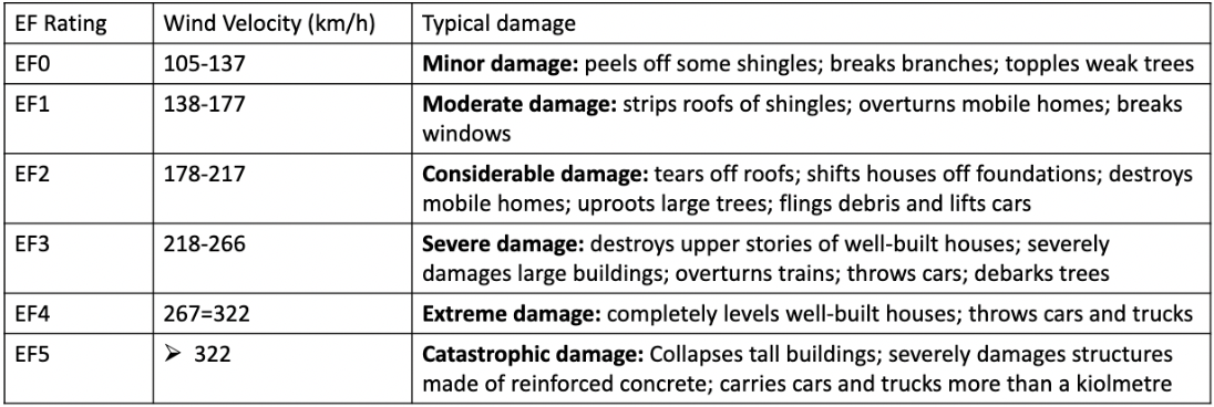
The Enhanced Fujita (EF)
scale is used to classify the tornado based on the damage it causes using correlation of observed damage and wind speed
Rivers and Floods - What is a stream?
A body of water confined within a channel, supplied with water by its drainage basin
What determines the size of a stream?
Climate
Size of drainage basin
Substrate
Vegetation
Stream Valley:
area between tops of slopes on both sides of the river
channel:
trough through which water flows
Thalweg
line connecting deepest parts of the channel
Discharge
volume of water flowing downstream/unit time (m3/sec)
Where would you expect to find the highest flow velocities in a stream?
Straight areas
Center of channel
Just below water surface
Around meanders
Outside of meander bend
Valley profiles - How does the shape of a valley change downstream?
Cross sectional profiles
Steep-sided, V-shpaed near source, canyons
Broader valleys downstream
Longitudinal profile
Steep gradients near source
Low gradients downstream
Base level
Deepest level to which streams can erode
Usually sea level (but not always)
Channel morphology
Sinuosity is used to classify channels
Ratio of stream length: valley length
Meandering streams
Common in areas with low slopes
Thalweg close to outer bend of meander
Outside bend of meander - deepest water, highest flow velocities: cutbank
Inside bend of meander: point bar
Erosion of cutbank, deposition on point bar = migration of meanders
Meanders can join - form neck cut off
Oxbow Lake: crescent shaped lake formed where a meander is cut off from a stream
Flood plain
Broad strip of land built by sedimantation on each side of the channel
Covered with water when river floods
Coarset material deposited closest to the channel - forms levees
Finger-grained material carried further away - clays and silts
What kinds of sediment do meandering streams deposit?
On point bar
Snad and silts (ripples and dunes)
On floodplain
Silts and clays
With migration forms
Fining upwards sequence
Flood vs. Shore floods vs. Inland floods
Flood - an event during which water covers significant areas of land that are normally dry, a stream floods when its discharge becomes so great that water overtops its stream’s banks and submerges areas outside its channel
Shore floods - associated with storm surges, storm waves, tsunamis
Inland floods - oversupply of freshwater from rainfall or melting snow
Braided Streams
Multiple channels
Common on steep clopes
Common in glaciated or arid regions
Channels split and rejoin
Areas of deposition between channels
What kinds of sediments?
Coarse-grained
Gravel and sands
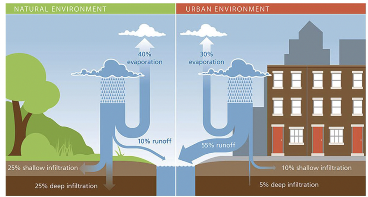
Urban river systems - How does urbanization affect river systems?
What environmantal hazards are associated with fluvial environments?
Ground surface less permeable
Less infiltration of rainwater
More storm runoff
Increased flooding
What happens once water falls to the ground?
Infiltration
Process through which water on the ground enters into the soil
Amount of infiltration dependent on
Soil moisture
Substreate
Slope
Type of vegetation
Intensity of precipitation
Flood Hydrograph
Shows effect of storm event on river discharge
Urban rivers have ‘flashy’ discharge
Water enters river quickly, causes high flood peaks
Hamilton Flooding Risk
Hamilton is likely to experience flooding this year, as the Lake Ontario water levels are at a historical high
City has very few options for prevention due to the length of the shoreline
Sandbags would not be effective due to the force of wave action
Popular trails are being flooded
Parking lots near the harbour
Hamilton has spent over $700,000 on repairs form 2017 and 2018 flooding
Ottawa Floods
Ottawa experiences severe flooding in April 2019
Data gatherers by CSA between April 20-30
In this time
2196 homes were flooded or at risk of flooding
3800 homes and octtages were affected in Gatineau
100km of roads flooded
In total 42km2 was flooded in Ottawa
39km2 in Gatineau
Damaged houses, path, bridges, and shorelines
National Capital Commission could spend $10 million in repairs
Looking to prepare for the future to reduce damages
Urban Systems
Erosion of stream banks, clogs channels
Sediment poses problems for fish
Reduced water quality
Urban runoff contains road salt, grease oil
Bluffers Park, Scarborough, 1991
Know differences from natural environment to urban environment