coastal systems and landscapes notes
1/53
There's no tags or description
Looks like no tags are added yet.
Name | Mastery | Learn | Test | Matching | Spaced | Call with Kai |
|---|
No analytics yet
Send a link to your students to track their progress
54 Terms
System
Assembly of interrelated parts that work together by some driving process
Open system
A system that transfers both matter and energy across its boundary to the surrounding environment. e.g. most ecosystems
Closed systems
A system that transfers energy but not matter across its boundary to the surrounding environment e.g. earth
Inputs
The addition of energy and matter into a system
Outputs
The movement of matter and energy out of a system.
Flows/Connections/Transfers
A form of linkage between one store / component that involves movement of energy
Stores(component)
A part of a system where energy / mass is stored or transformed
DYNAMIC EQUILIBRIUM
Balance between inputs & outputs
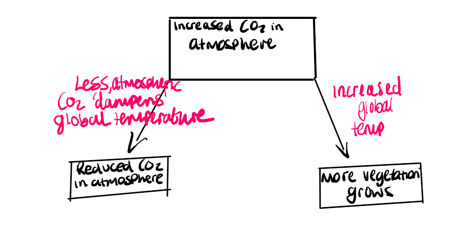
Positive Feedback →Moving further away from dynamic
Negative Feedback →when its getting closer to reaching a dynamic equilibrium
Positive Feedback
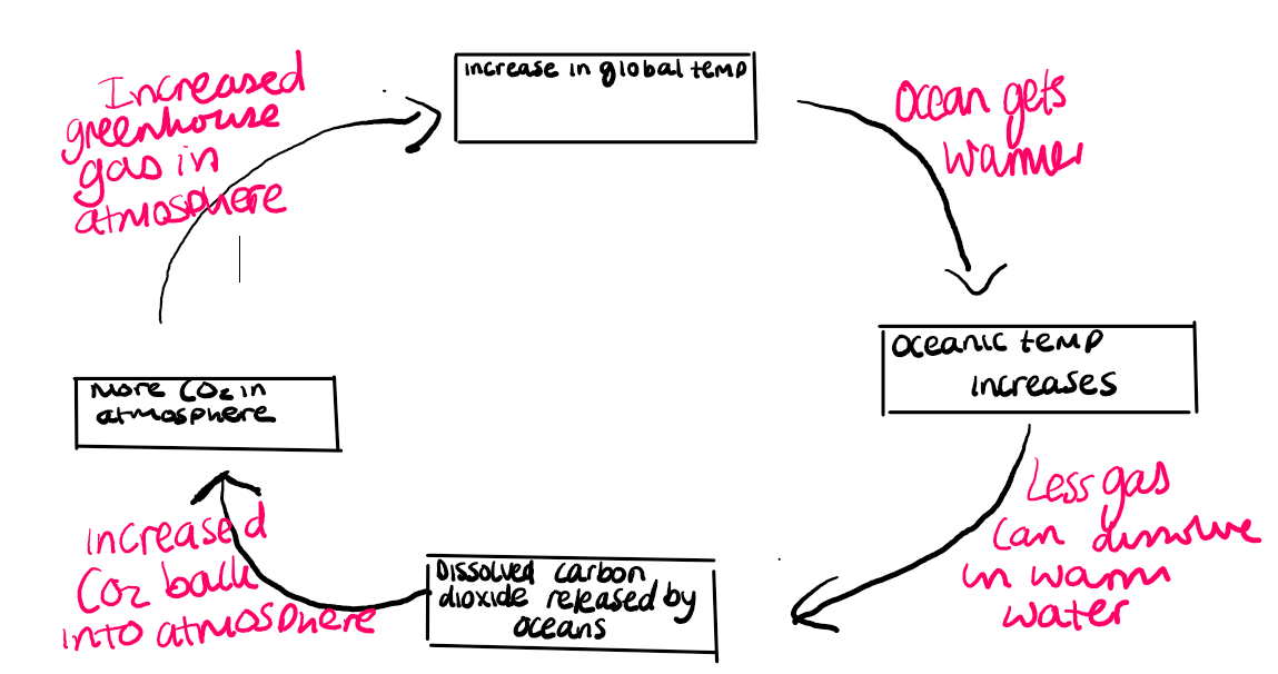
Negative Feedback
Weathering and Erosion
Weathering is the breakdown or disintegration of rocks in
This makes erosion take place more easy and quickly
Erosion
Hydraulic action → Air is trapped and compressed in cracks in rocks, causing them to break apart
Wave Quarrying → When waves break against sands and gravels it scoops out the loose material
Corrasion → Material is thrown at the base of a cliff, chipping away at the rock
Abrasion → Sand paper effect, eroding and smoothing rocky surfaces
Solution → Acids in seawater can dissolve alkaline rocks
What factors influence the rate of erosion?
-Sheltered or more exposed
-Geology → rock type
-Destructive waves
-Breaking point of wave
-Stormy weather
Factors influencing the rate of erosion
Wave steepness - Very steep destructive waves formed locally have more energy & erosive power than gentle destructive waves formed many KM away (swell)
Depth of sea - Length & direction of fetch, configuration of coastline
Mass Movement - Downhill movement of material under the influence of gravity
Mudflows - Earth and mud flowing downhill, usually over weak rock after heavy rainfall
Landslide - A fast moving block of rock that is usually triggered by an earthquake or heavy rainfall when friction is reduced
Rockfall - Sudden collapse or the breaking away of individual rock fragments at a cliff face associated with steep cliffs & resistant rocks.
Waves and Tides
Wavelength - Distance between either a trough & a trough or a crest and a crest
Wave height - How tall the wave is
Crest - The highest point of a wave
Trough - The bottom of a wave
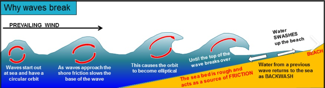
Formation of waves
Fetch→ How long the wind is blowing over the surface of water and how long/distance maximum length of open water which the wind can blow unobstructed & it determines how long the wind blows for.
Wind plays a vital role in wave formation. Waves are created by the transfer of energy from the wind blowing over the sea surface. The energy acquired by waves depends upon the strength of the wind, the length of time it is blowing and Fetch
Why waves break
Destructive Waves
-The backwash is stronger than the swash & so material is eroded
-A larger wave frequency
-A steeper beach is created (eroding sediment from the beach and carrying it away, resulting in a steeper beach profile)
-Wave height is smaller
Constructive waves
-The swash is stronger than the backwash & so material is deposited
-A smaller wave frequency
-Wave height is smaller
Negative Feedback System
Constructive waves build up the beach (material is deposited) resulting in a steeper beach profile. This encourages waves to become more destructive →with time, though destructive waves move material more back towards the sea, reducing the beach angle & encourage more constructive waves
→so the pattern repeats itself
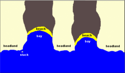
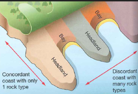
Headlands and bays
Bands of hard and soft rock make up a discordant coastline
Differential erosion means that the soft rock is eroded quicker
Continual erosion → hydraulic action and corrosion - mean the soft rock further eroding leaving a headland sticking out to sea and a bay retreating backwards
Wave refraction means that waves energy becomes focused around the headland - erosion continues
Wave energy is less in the bay & so sediment is deposited here e.g. sand
Wave refraction
involves waves breaking onto am irregularly shaped coastline e.g. headland. Separated by 2 bays. Waves drag in the shallow water approaching a headland so the wave becomes high, steep and short. The part of the wave in the deeper water moves forward faster causing the wave to bend.
Discordant coastline & Concordant coastline
Headlands and bays most commonly form along discordant coastlines. Discordant coastlines form where geology alternates between bands of hard and soft rock
Where the coasts has the same type of rock along its length fewer bays and headlands are formed as the rate of erosion tends to be similar. These types of coast are known as concordant coastlines. The outer hard rock (for example, granite) provides a protective barrier to erosion of the softer rocks (for example, clays) further inland.Sometimes the outer hard rock is punctured, allowing the sea to erode the softer rocks behind. This creates a cove, a circular area of water with a relatively narrow entrance from the sea.
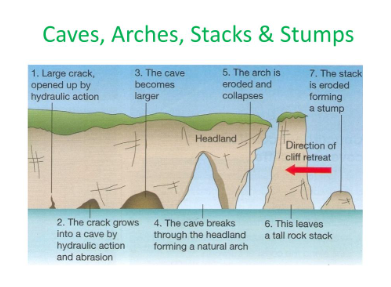
Cave, arch, stack, stump
Cave, arch, stack, stump simple
Cliffs and wave cut platforms
Cliffs are common features of coastal environments. Over time cliffs retreat due to a combination of sub-aerial weathering and coastal erosion. Wave action and weathering create a notch at the high water mark.Over time the wave-cut notch will develop into a cave. Eventually, the weight of the unsupported cliff will cause it to collapse. As the cliff collapses a layer of flat rock is left behind called a wave cut platform. The platform typically has a slope of less than 4 degrees, which is often only fully exposed at low tide. Wave cut platforms have a significant impact on the ability of waves to erode the base of the cliff. This is because the waves have further to travel in very shallow water as the platform grows. Waves tend to break earlier before they can erode the base of the cliff.
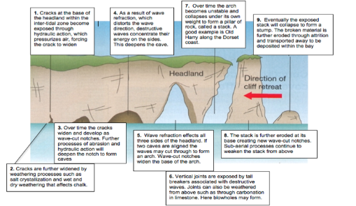
Cracks Caves, blow holes, arches and stacks
Cracks are regularly formed in more resistant rock that forms headlands. The image below shows cracks in the chalk cliffs at Flamborough, Holderness Coast. Over time the crack will erode further, as the result of erosional processes such as hydraulic action. The video below shows chalk bedding planes (layers) with joints (vertical cracks) in the chalk cliffs at Flamborough. Occasionally, wave action and weathering erodes joints in the cave roof to form a blow hole. Where the cave erodes through the headland an arch is formed Eventually, the crack will enlarge and become a cave. When the roof of the arch collapses a stack is formed.
Sediment Cells
A sediment cell is defines as a length of coastline, which is essentially self-contained as far as the movement of sediment is concerned
The boundaries of the sediment cells generally coincide with large estuaries or prominent headlands which disrupt the movement of sediment
There is also a depth of closure, beyond which the water is too deep for waves and tidal currents to transport sediment
Clastic Sediment
-Comes from weathering rock & varies from very small clay particles to sand/pebbles/boulders
Biogenic Sediment
→ skeletons & sediments of marine organisms
Non-cohesive sediments
Larger particles moved grain by grain
Cohesive Sediment
→Very small clay & mud particles that bond together
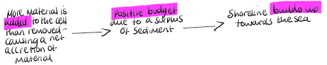
Sediment Budgets
These involve the inputs and removal of sediment within a sediment cell. The aim is for it to be in dynamic equilibrium with the same amount of inputs to losses. However, this is not always the case
Sediment Budgets
(positive budget)
Sediment Budgets
(Negative Budget)

Landforms of deposition
Coastal landforms of deposition occur where the accumulation of sand and shingle is greater than it is removed. This is particularly the case where constructive waves are prevalent or where there is an abundant amount of beach material supplied.
Seasonal change in beach gradient
The gradient of the beach tends to change during the year. Beaches are typically steeper in summer. This is because constructive waves are more common in summer, but destructive waves are more common in winter.
Ridges and runnels
The strong swash of a constructive wave deposits the largest material at the top of the beach. As the upper beach builds up, the backwash becomes even weaker because a greater proportion of the water drains away by percolation, rather than running down the beach. The weak swash of a destructive wave deposits material at the base of the beach. It cannot advance further up the beach because it is destroyed by the backwash from the previous breaking wave. Ridges and runnels form parallel to the shoreline in the foreshore zone. Ridges are areas of the foreshore that are raised above the adjacent shore which dips into a runnel. The runnels are disrupted by channels that help to drain the water down the beach.
Ridge and Runnel
Ridge and runnel systems are formed due to the interaction of tides, currents, sediments and the beach topography. They only form on beaches with a shallow gradient. They form as a simple drainage route for tides. Water flows in and out via the runnel.

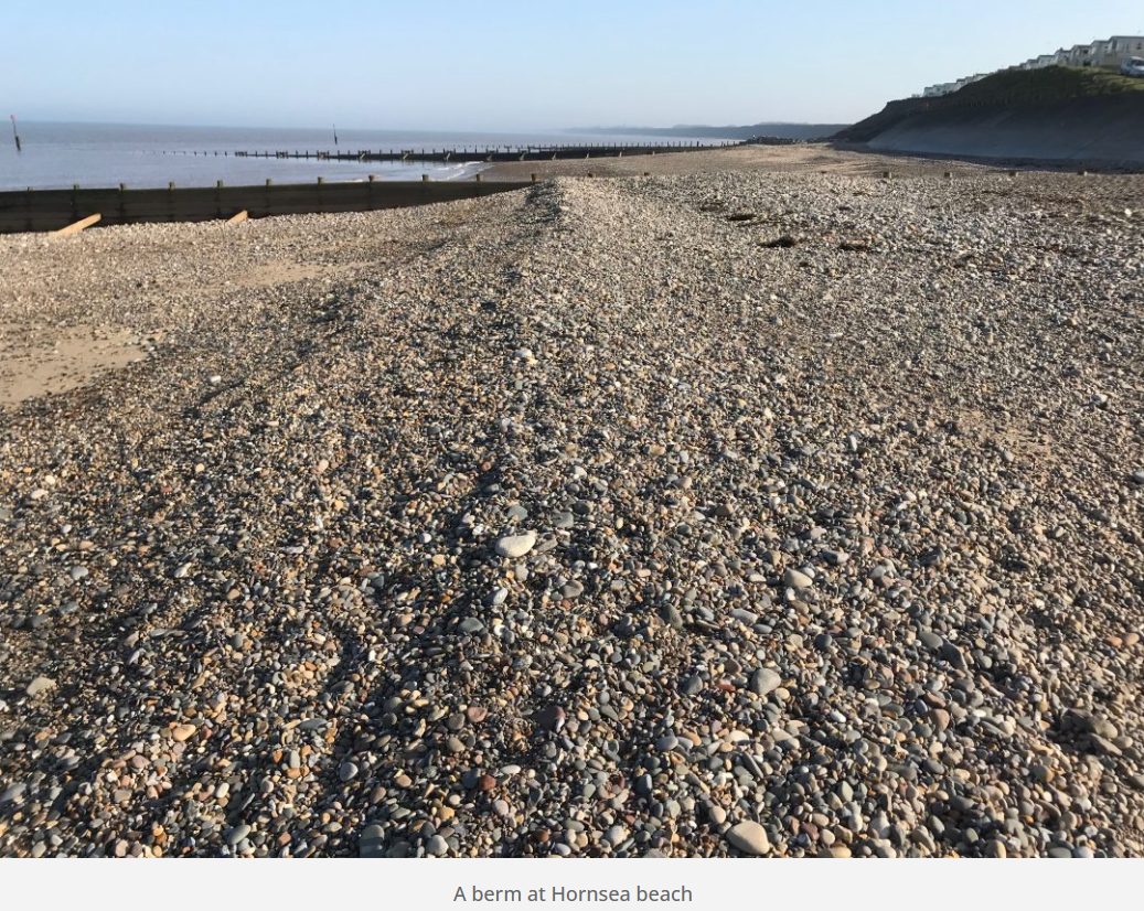
Spring Tides
+ Berms
Spring tides often form a storm ridge which consists of the largest material thrown up by the strong swash of the larger waves. Following tides often cannot reach these features, therefore, they remain largely untouched. There are often a series of smaller ridges formed beneath the storm ridge known as berms. These mark the successive high tides that follow the spring tide through to the neap tide. The images below shows a berm on Hornsea beach.
Cusps
Cusps are crescent-shaped indentations that form on beaches of mixed sand and shingle. They are formed where there is a junction between sand and shingle. Once the curving shape is created, swash is concentrated in the small bay that forms in the centre of the cusp. This creates a stronger backwash that removes material down the beach.
Long shore drift
The process relies on prevailing oblique winds that send water down the coast generating a water current which in turn advances parallel to the coast.
Spits
Spits are formed where the coast suddenly changes direction e.g. across a river mouth. Longshore drift continues to deposit material across the mouth of a river which results in the formation of a long bank of sand and shingle. The image below shows Spurn Point which has been formed by the deposition of material transported by longshore drift from north to south along the Holderness Coast. Where the coast changes direction where it meets the mouth of the Humber Estuary this material continues to be deposited forming Spurn Point. A salt march has formed on the inside, sheltered side of Spurn Point (right of the picture).
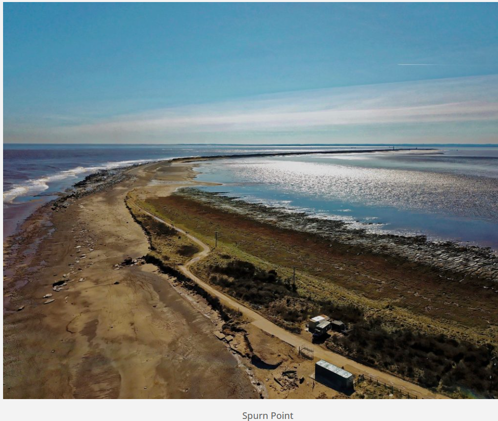
spit (recurved end)
Changes in the prevailing wind and wave direction can cause a spit to form a recurved end. Over time several recurved ends may form as waves return to their dominant direction. Where the wind is strong enough to lift sediment of the beach dunes may form which adds stabilisation to the spit when pioneer plants such as marram grass anchor the sand.
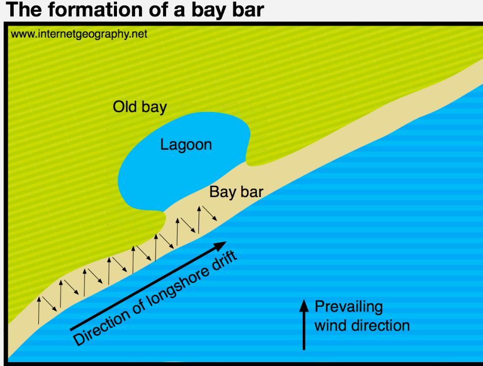
Bars and Tombolo
A bar is a spit that joins together two headlands. Bars are particularly obvious at low tide when they become exposed. At high tide, bars make the water shallow which often causes waves to break early. A lagoon may be formed within a bay as the result of a bar.
Where a spit links the mainland and an island a tombolo is formed.
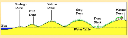
Dunes
Dunes are landforms formed from sand deposits that have been blown off the beach. Where sufficient sand is deposited and dries in the intertidal zone (foreshore – the area between the high and low tide marks) it is then transported by saltation by the blowing wind. Sand dunes only form where the rate of beach deposition is greater than erosion (positive sediment budget).
SAND DUNES
(different stages)
The first dunes to form are known as embryo dunes. They contain species such as lyme grass, sand couch and marram grass. These species survive by growing upwards through accumulating wind-blown sand. These plants add organic matter to the dunes making the dunes more hospitable for plants that later grow. These dunes tend to grow to around 1m. The next stage in the sequence of sand dune development is the formation of foredunes or yellow dunes. These are initially yellow but darken as organic material adds humus to the soil. The dunes remain slightly alkaline. Foredunes tend to grow to around 5m in height and around 20% of the sand is exposed (this is down from around 80% of embryo dunes). Very little moisture exists in this area. The next stage is the formation of grey dunes and dune ridges. By this stage, the dunes are more fixed. The soil becomes increasingly acidic as more humus forms which in turn increases water retention. Combined this allows new species of plants to thrive e.g. creeping willow and dewberry. Less than 10% of the sand is exposed on these dunes which tend to be between 8-10m high. As sand dunes become colonised with vegetation roots stabilise the sand and hold it together. The video below shows an area of sand dune at Spurn Point where erosion has caused the dune to begin to collapse. The erosion has exposed a cross-section of the dune revealing the depth of the roots.Very little sand from the beach accumulates beyond the grey dunes and dune ridges which leads to the formation of wasting dunes. Here the soil is more acidic, water retentive and rich in humus. The typical vegetation here includes heather and gorse. Dune height here is usually between 6-8m high.
Salt Marshes
Salt marshes often occur in sheltered river estuaries or behind spits. Vegetation develops in the intertidal mudflats found in these areas. An example of this is behind Spurn Point in the Humber Estuary.
Sea Level Rise
Sea level rise occurs as the result of both eustatic and isostatic changes.
Eustatic Changes
Eustatic refers to worldwide variations of sea level resulting from climate (and so hydrological cycle) change. For example, during an Ice Age more precipitation falls as snow. Therefore, water cycled from sea to land (through evaporation, condensation and then precipitation) is now stored as snow and ice and does not return to the oceans. Consequently, sea levels fall. When the glaciers and ice sheets melt, sea levels rise again.
sea level fall & rise
Isostatic Changes
Isostatic adjustments may result from tectonic uplift or changes caused by the enormous weight of ice depressing the crust during an Ice Age, only for the land subsequently to uplift (rebound) on melting.
Land rises or falls
Eustatic and Isostatic Changes
Both eustatic and isostatic changes can occur at the same time, resulting in the flooding of the existing coastline or exposure of new land previously covered by the sea. For example, if isostatic recovery is faster than eustatic sea level rise, then emergent features are produced. If, however, eustatic rises dominate, then submergent features result.
The future
While current temperatures and sea levels can be measured across the globe, the prediction of future changes using computer global climate models (GCMs) is less certain. GCMs are highly sophisticated but not infallible. By simulating atmospheric conditions using past climatic records, ‘proxy’ evidence from ice cores and a wealth of corroborative information, they allow researchers to predict future climatic scenarios within broad ranges. These projections depend upon data input.