Esri ArcGIS Pro Foundation Certification 2025
1/353
There's no tags or description
Looks like no tags are added yet.
Name | Mastery | Learn | Test | Matching | Spaced | Call with Kai |
|---|
No analytics yet
Send a link to your students to track their progress
354 Terms
ArcGIS Pro Projects
allow you to store: databases, folders, maps, styles, toolboxes, and layouts.
Tab
each (blank) has its own set of tools and buttons, which are organized into groups.
Groups
Organize functionality of the tools and buttons on a ribbon tab
Tool/button
Execute actions in ArcGIS Pro
View
are used for working with maps, scenes, and other data. A project can contain several (blanks), but only one (blank) is active at a time
Pane
is a dockable window in ArcGIS Pro. Shows the contents of the active view or allows you to access all items associated with the project in one place.
Which element of the ArcGIS Pro user interface displays the contents of the active view?
Contents Pane
Which two statements best describe ArcGIS Pro capabilities?
Create 2D and 3D maps to visualize data
Use artificial intelligence to recognize complex patterns
Imagine that a spatial analyst has created a project in ArcGIS Pro. Which two items can be stored in the project to use when needed?
Maps and Layouts
Which option would be the best choice to view all the features of a specific layer on your map?
in the contents pane, right-click the layer and choose Zoom to layer
Which statement best describes how to share a web layer in ArcGIS Pro?
right-click the layer in the contents pane
GIS Coordinates
x coordinate = horizontal distance from the point of origin
y coordinate = vertical distance from the point of origin
z coordinate = the height of a point from the ground
What shape is the earth?
Oblate Ellipsoid/Spheroid
Two most common spheroids used in North America
GRS80 and Clarke 1866
Coordinate Systems
Geographic coordinate systems: uses a three-dimensional spheroidal model to identify points or areas on the surface of the earth.
Projected coordinate systems: used to convert feature locations from the spheroidal earth to a flat map. To do so, latitude and longitude coordinates from geographic coordinate systems are projected to planar coordinates.
Which statement best describes the shape of the earth?
The earth is an oblate ellipsoid, which closely approximates a sphere.
At which scale do differences in spheroids generally become visible?
1:5,000,000
Which two statements best describe why maps need coordinate systems?
Coordinate systems help accurately match a location on the earth with a location on a map.
Coordinate systems ensure that geographic information is placed accurately on a map.
Which two statements best explain why multiple spheroids are used to model the shape of the earth?
Different spheroids provide refined accuracy for different regions of the earth due to deviations in the earth's shape.
Over time, improvements in measuring the earth result in spheroids with greater accuracy to model the earth's shape.
Which two statements accurately define the types of coordinate systems that are used in a GIS?
A projected coordinate system converts locations from the spheroidal earth to a flat map based on a geographic coordinate system.
A geographic coordinate system uses a 3D spheroidal model to identify locations on the surface of the earth.
Each coordinate system is commonly illustrated with a network of intersecting lines of latitude (parallels) and longitude (meridians) called a what?
graticule: imaginary on the earth, but it is drawn on globes and maps for reference.
How are longitude and latitude coordinate values represented?
As angles measured from the earth's center to a point on the earths surface. The angles often are measured in degrees (or in gradians).
Prime Meridian
zero value for longitude.
Datum
Provides a frame of reference for measuring locations on the surface of the earth. Defines the origin and orientation of latitude and longitude lines.
Defines the position of the spheroid relative to the center of the earth.
What option best describes the impact of using multiple geographic coordinate systems?
Using multiple geographic coordinate systems contributes to data misalignment.
Which two statements explain why geographic coordinate systems provide a foundation for GIS functionality?
A geographic coordinate system enables your GIS to accurately display spatial data on a map.
The presence of a geographic coordinate system is necessary for your GIS to properly interpret coordinate values.
Which three statements about geographic coordinate systems are true?
A geographic coordinate system is represented by a graticule of intersecting parallels (latitude) and meridians (longitude).
A geographic coordinate system's coordinates are based on latitude and longitude values.
A geographic coordinate system uses a three-dimensional spheroidal model to identify specific locations on the earth.
To create a map to compare global data, which type of spatial reference should be used?
Earth-centered datum
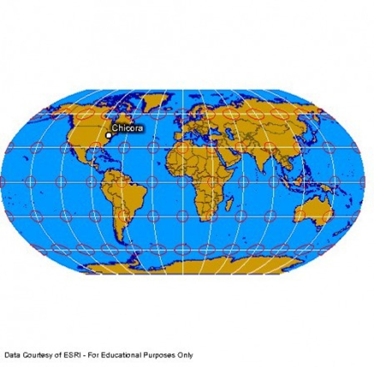
Cylindrical projections
Created by wrapping a cylinder around a globe and projecting projecting light through the globe onto the cylinder. These projections represent meridians as straight, evenly spaced, vertical lines; they represent parallels as straight, horizontal lines. Meridians and parallels intersect at right angels, as they do on the globe.
Conic projections
Created by setting a cone over a glove and projecting light from the center of the globe onto the cone. The simplest conic projection contacts the globe along a single latitude line called the standard parallel. in general distortion increases north and south of the standard parallel.
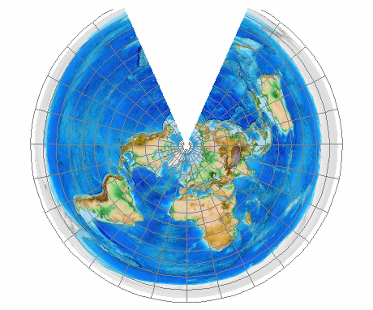
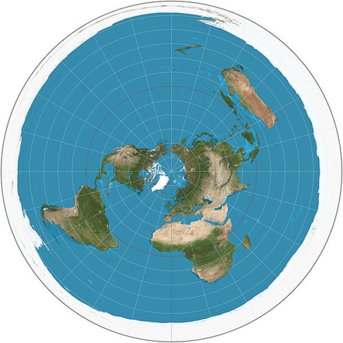
Azimuthal/planar projections
Project map data onto a flat surface. When that point is either the north or south poles, longitude lines radiate outward from the pole at their true angle. Latitude lines appear as a series of concentric circles. Used most often to map the polar regions.
Projection type guidelines
for map areas that extend north-south, use a cylindrical projection
For map areas that extend east-west, use a conic projections
for map areas that have equal extent in all directions, use an azimuthal projection
Conformal projections
preserve shape but not area
Equal Area Projections
Preserve area but not shape

Equidistant Projection
preserves true scale between one or two points to every other point on the map, or along every meridian.
Azimuthal Projection
preserve direction from one or two points to every other point
Gnomonic Projection
Preservers the shortest route (distance and direction) but cannot preserve area.

Ribbon
The ArcGIS Pro (blank) displays functionality through a series of tabs, groups, and tools/buttons that you can use to perform various tasks.
Compromise Projection
Try to balance shape and are distortion. No property is completely accurate, but not property is extremely inaccurate.
To create a map that has minimal distortion but does not perfectly preserve any of the four spatial properties, which type of projection should be used?
Compromise
Which two statements identify map distortions introduced by projections?
Projections introduce distortions to at least two properties of a map: shape, area distance, or direction.
Projections introduce distortions to some areas of the map while preserving map properties in other parts of the map.
Which two statements about projected coordinate systems are true?
A projected coordinate system's coordinates are measured in linear units, such as feet or meters.
A projected coordinate system gives linear measurements on a planar surface from a predefined starting point.
To create a map for measuring how much total land is part of a national park, which spatial property should be preserved?
Area
Which three surfaces are developable surfaces for creating map projections?
Cylinder
Cone
Plane
Geocoding types
you can geocode one location description at a time and zoom to its location on a map or geocode a table with multiple descriptions and plot multiple points on the map
Data types
there are two main data types: input data, the data you are trying to place on a map; and reference data, the geometry and attributes that are used to locate the feature.
Locators
tools that use reference data to place input data on a map; locators can be local or published as an online service.
Which two scenarios are examples of when enabling location on nonspatial data would be important?
Geocoding can be used to map the location of a local fitness club with only street address data.
True
What is meant by geocoding?
Transforming a location description into a location on the earth's surface
Which example of location data could be added to a crime incident map in ArcGIS Pro to create crime hot spots?
Burglary Incident Coordinates
Which method would most likely be used in a nationwide census to place people's locations on a map?
Address
Which two attributes could be used when applying the place-name method to enable location on nonspatial data?
title field
Description field
input data
first component required for geocoding. Contains the location description and is provided by the user.
locator
tool that ties the location descriptions in the input data to geographic coordinates to place features on a map. Locators can be created that place features by their street address; by their names, landmarks, natural features, or other places.
Reference data
A locator requires reference data to map features. After identifying address elements in the input data, the locator uses a set of rules to compare address elements from the input data to reference data. The locator finds matches between the input and reference data and places features on a map. The quality of your search results depends on the quality and accuracy of the reference data as well as of the input data. You can refresh a locator whenever your reference data is updated.
Types of locators
free locators: such as ArcGIS Online World Geocoding Service
Paid locators: for use behind a firewall, such as when you are using an on-premises portal instead of ArcGIS Online
Locators that you build yourself
Locators components
Building addresses: Points, streets, postal codes, parcels, building footprints
Points of Interest: landmarks, place-names, buildings, businesses, natural features
Populated Places: cities, regions, countries, postal codes
Other locations: wells, parking meters, census tracts, and so on
Locator sources
Another way that locators differ is by the source for the locator. A composite locator uses other locators instead of a table of reference data, like an address or other locator would. Composite locators allow you to perform a variety of searches for different types of features with the same locator.
What is meant by the address component called street type?
The street suffix, such as Avenue or Boulevard, and so on
What does having different types of reference data allow you to do?
Provide different input fields to the user
Which item do you need to create a locator for geocoding?
Reference data
Which method is the best way to get accurate search results from your address locator?
Have the most precise reference and input data
Place-name locators
a locator tool searches descriptive attributes, and a place-name may be an attribute in your data
The location of a feature that has a street address will also have Name as an attribute, appropriate for a place-name locator.
false
If a locator provides multiple results, which action would help locate the correct feature on a map?
Use an attribute query
To create a place-name locator, which attribute is needed?
Reference data with a name field
Which sources are used to create a composite locator?
Other locators
Which of these examples is not a place that could be located on a map by its name?
Pine avenue and main street
X,Y data orientation
In geographic coordinate systems, x represents longitude (east-west) and y represents latitude (north-south).
X,Y Relationship to Spatial Data
Although spatial data, by definition, has location, it may not have x,y information as a descriptive attribute. Coordinate data, or x,y, data, describes location. It can be used to map features regardless of whether the data is contained in a spatial data file.
X,Y data tools
Unlike with addresses and place-names, using x,y data does not require locators supported by tables of reference data. You can employ ArcGIS Pro tools, such as the Locate pane, Go To XY, XY Table To Point, or Make XY Event Layer, to use x,y data.
X,Y Data in Geographic coordinate systems
The x,y coordinates (in degrees) can be written out as degrees/minutes/seconds (DMS); decimal degrees (DD), which converts the minutes and seconds to decimal notation; and degrees/decimal minutes (DM), which is a combination of the two.
DMS: 87°39'21"W, 41°56'52"N
DD: 87.6558018°W, 41.9479111°N
DM: 87°39.3492538'W, 41°56.8723714'N
X,Y Data in Universal Transverse Mercator (UTM)
UTM is a projected coordinate system and a commonly used standard for specifying location. This system divides the earth into 60 zones, each 6° wide.
10S 706832m E, 4344683m N (10S is the zone, and then the easting and northing values are given in meters)
X,Y Data in Military Grid reference System (MGRS)
MGRS is derived from UTM and the Universal Polar Stereographic (UPS) grid system. MGRS coordinates consist of the grid zone designator (GZD), the 100,000-meter square identifier within the zone, and the numerical location.
4QFJ 12345 67890 (4Q is GZD, FJ is the grid square ID, and 12345 67890 are the easting and northing values; with more digits comes more precision)
X,Y Data United States National Grid (USNG) System
USNG is derived from the MGRS. A USNG spatial address is broken down into the GZD, for a world-wide unique address; the 100,000-meter square identifier, for regional areas; and the grid coordinates, for local areas.
18S UJ 22850 70501 (18S is the grid zone, UJ is the 100,000-meter square, and 22850 70501 are the easting and northing values)
X,Y Data Ordnance Survey National Grid System
The Ordnance Survey National Grid is a geographic grid reference system used in Great Britain, based on UTM and the OSBG36 and WGS84 datums. A coordinate description consists of the grid square and the grid coordinates.
NN 166 712 (NN is the grid square, and 166 and 172 are the easting and northing values)
How is x,y data used to locate a feature on a map?
The x value represents the east-west location and the y value represents the north-south location. The
Which two table fields could be used to map x,y values?
Point_Y
Longitude
Which two examples of x,y data can be located on a map?
LONG and LAT fields in a table
39.41, -105.5
Feature Attributes
Most GIS data includes features and an attribute table. The features represent the location of an object on a map. The attribute table provides descriptive information about the features (for example, their size, address, age, and so on). This information is referred to as the attributes of the feature (or data). You can use these attributes to search and query your data.
Object Identifiers
ArcGIS maintains object identifiers, which guarantee a unique ID for each row in the table
Numbers
Numbers are used to associate a quantitative value with a feature—an example is the cost to rent a house. Numbers can be defined as Short Integer, Long Integer, Float, and Double. Short and Long Integers both represent whole numbers. Both Float and Double represent decimal numbers.
Text
Text is used to categorize data. For example, it can differentiate stores that sell clothes from those that sell food or electronics. Text is also used to describe the data—for example, the states or countries where the stores are located.
Dates
Date types store times, dates, or times and dates for each feature.
Attribute Field
the attribute field determines which field to query in the attribute table
Attribute Value
identifies the value that you are searching for in each record of the attribute table
Operator
represents the measurement that you will use to query a selection of features. does not have to be an exact value, it can search for a greater or lesser value, a newer or older value, and so on.
Multiple Attribute queries
The AND operator only selects features that meat the criteria in both attribute queries. The OR operator selects features that meet the criteria in either attribute query.
Review the following attribute query:
Population Is Greater Than 500,000
Population is which component of the attribute query?
Attribute Field
Which attribute query will select any parcel that has an area that is smaller than 800 square meters?
Area is Less Than 900
A retail analyst is using ArcGIS Pro to analyze the sales data of a big box retail store. The sales data includes attributes such as PymtType (a text data type) and SaleAmount (a number data type). The analyst wants to find all credit card transactions that had a sale amount of at least $500. Which attribute query would the analyst construct to obtain this information?
PymtType Is Equal to Credit AND SaleAmount Is Greater Than 500
A warranty manager for a homebuilder uses a tracking system to manage warranty claims. In the system, the attribute field Priority categorizes each claim based on urgency. The field can contain three different values: High, Medium, or Low. In this example, which data type is associated with the Priority attribute field?
text
Vector Data
Vector data is composed of geometry and attributes. Geometry can be points, lines, or polygons that represent real-world features. Attributes provide information about these real-world features. In this example, a building is represented by a polygon, a road is represented by a line, and a telephone pole is represented by a point.
Points
The most basic type of vector data
Lines
Line features use a set of vertices to draw each line
Polygon
like line features, polygon features use a set of vertices to draw each shape. However, the lines created by a set of vertices are closed for polygon features.
Raster Data
Raster data is a grid of matrix of uniformly sized cells. In this example, each cell contains a value for elevation. raster's can be used to map continuous phenomena, such as elevation, air pressure, and temperature.
Derived Rasters
ArcGIS can create derived raster products that add context and value. The higher resolution raster contains values for elevation. Based on this elevation value, ArcGIS has calculated slope and aspect for each given point.
Imagery and scanned maps
Rasters can also display discrete phenomena, such as scanned maps or satellite imagery. Imagery and color photographs may have multiple bands.