APHUG unit 1 vocabulary
0.0(0)
Studied by 75 peopleCard Sorting
1/48
Earn XP
Description and Tags
Last updated 10:56 PM on 9/10/22
Name | Mastery | Learn | Test | Matching | Spaced | Call with Kai | Chat |
|---|
No analytics yet
Send a link to your students to track their progress
49 Terms
1
New cards
Photographic interpretation
photos geographers take of a place to gather observable data about the world. These photos can be taken from the ground or by using aerial photography(images taken from an airplane by a professional).
2
New cards
Elevation
the distance of features above sea level-usually measured in feet or meters, and can impact climate, weather, agriculture, etc. Higher_____: colder temperatures; becomes harder for certain crops to grow.____is shown on maps with contours(isolines).
3
New cards
Sustainability
trying to use resources in ways that allow their use in the environment. Ex: stemming from natural resource depletion, mass consumption, the effects of pollution, and the impact of climate change.
4
New cards
Thematic maps
show spatial aspects of information or of a phenomenon. Ex: Choropleth, Dot-distribution, Graduated Symbol, Isoline; Cartogram.
5
New cards
Satellite Imagery
images of the Earth taken from artificial satellites orbiting the planet.
6
New cards
Absolute Location
precise spot where something-usually described by longitude and latitude
7
New cards
Census Data
specific information about people. Can be collected by: surveys, the general view, examination, or description of someone or something. Inaccuracies can happen while information is collected as people can lie, be counted twice, or under count homelessness.
8
New cards
Distance Decay
increase relationship between distance and connection. Ex: the weakening in radio signal as it travels across space away from a radio tower. Friction of Distance causes the decay, or weakening of the signal.
9
New cards
Time-space Compression
the shrinking "time distance," or relative distance, between locations because of improved methods of transportation and communication. Ex: London and NYC are an ocean apart; however, it feels closer due to modern methods of transportation like airplanes.
10
New cards
Pattern
refers to the general arrangement of things being studied, and geographers must be able to describe _____ accurately and precisely.
11
New cards
Natural Resources
items that occur in the natural environment that people can use. Ex: air, water, oil, fish, soil, and animals.
12
New cards
Land Use
study of how land is utilized, modified, and organized by people. Geographers study the patterns of this concept and draw conclusions on the reasons for the specific use and the varying impacts on the environment, landscape, and people.
13
New cards
Absolute Distance
usually measured in terms of feet, miles, meters, or kilometers; is a measurement of how far or how near things are to one other. Ex: The library is 1.5 miles away from the school.
14
New cards
Personal Interviews
geographers may interview experts to gather information about a specific place. Ex: a naturalist being interviewed about local birds in the Galapagos Islands.
15
New cards
Place
refers to the specific human characteristics of a location.
16
New cards
Flows
refers to the patterns and movement of ideas, people, products, and other phenomena.
17
New cards
Relative Distance
indicates the degree of nearness based on time or money often dependent on the mode of travel. Ex: the library is 10 minuets away from school
18
New cards
Geospatial Information System(GIS)
a computer system that collects, stores, analyzes, and displays geographic data.
19
New cards
Relative direction
directions such as left, right, up, down, forward, and backward are based on people's perception of places. Ex: Canada is above the United States.
20
New cards
Clustering
arranged in a group or concentrated in an area, and one of the six common distribution patterns. Ex: areas such as restaurants in a food court at a mall.
21
New cards
Dispersal
spread out over a large area.
22
New cards
Reference Map
named because they are designed for people to refer to for general information about places. Ex: Political, Physical, Road, and Plat.
23
New cards
Policy Documents
geographers may look to legislation to gather geographic data. Ex: the Great American Outdoors and passed by congress establishes the National Parks and Public Land Legacy Restoration to support maintenance projects of federal lands. Geographers may look at this document to access how land is being used.
24
New cards
Travel Narratives
stories and notes about descriptions made in the field.
25
New cards
Media Reports
data taken from things like newspapers, online news sources, and television to help get information about an area.
26
New cards
Environmental Determinism
the beliefs that land forms and climate are the most powerful forces shaping human behavior, and societal development while ignoring the influence of culture.
27
New cards
Remote Sensing
gather information from satellites that orbit the Earth or other aircraft above the atmosphere. Apart of developments in gathering data as a part of modern day technology. They gather data such as urban sprawl, droughts, and agricultural land usage.
28
New cards
Field Observations
is used to refer to the act of physically visiting a location, place, or region according to first hand information there. Geographers can often be found writing notes taking photos, sketching maps, counting and measuring things, and interviewing people as they walk through an area that they are interested in studying. This was the only way to collect data for the majority of history.
29
New cards
Map Projection
the process of showing a curved surface on a flat surface. The Earth is a sphere while a map is flat, so all maps are distorted in some aspect. Ex: Mercator, Peters, Conic, Robinson.
30
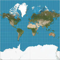
New cards
Mercator Projection
Navigation; directions are accurate, lines of latitude and longitude meet at right angles
31
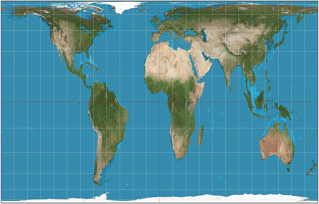
New cards
Peters Projection
spatial distributions related to area, sizes of land masses are accurate
32
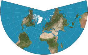
New cards
Conic Projection
general use in mid-latitude countries, lines of longitude converge, lines of latitude are curved, size and shape are both close to reality.
33
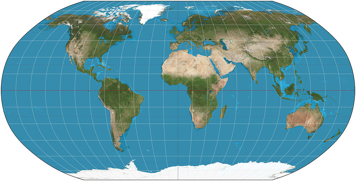
New cards
Robinson Projection
general use; no major distortion, oval shape appears more like a globe than it does a rectangle.
34
New cards
Mercator cons
distance between lines of longitude appears constant, landmasses near the poles appear large.
35
New cards
Peters cons
shapes are inaccurate, especially near poles.
36
New cards
Conic cons
direction is not constant; on a world map, longitude lines converge at only one pole.
37
New cards
Robinson cons
area, shape, size, and direction are all slightly distorted.
38
New cards
Space
the area between two or more phenomena of things. Geographers look through the lens of ____ to understand place. Geographers are intensely interested in how new ___ is arranged, used, and reflected in people's attitudes and beliefs.
39
New cards
Satellite Navigation Systems
can help provide much more specific data about the location of an object or place on Earth using geographic coordinates of longitude and latitude.
40
New cards
Landscape Analysis
the task of finding and describing landscapes.
41
New cards
Relative Location
description of where something is based on relation to other things. Ex: Salt Lake City is south of the Great Salt Lake and west of the Rocky Mountains.
42
New cards
Possibilism
in relation to environmental determinism contemporary geographers developed a theory acknowledging limits on the effects of the natural environment and focuses more on the role that human culture plays.
43
New cards
Global (scale)
the entire world. Ex: global Earth at night image, world population density map.
44
New cards
Regional (scale)
interactions occurring within a region, in a regional setting (North America, South Asia, Southeast Asia, Midwest, eastern China).
45
New cards
National (scale)
one country. Ex: the United States, Thailand
46
New cards
Local (scale)
a province, state, city, county, or neighborhood. Ex: Tennessee, Moscow
47
New cards
Formal Region
regions that are united by one or more traits: political(Brazil in South America), physical(Sahara in North Africa), cultural(Southwest Nigeria where most people speak Yoruba), and economic(Ghana who exports gold). Aka uniform or homogeneous.
48
New cards
Function Region
regional scale organized around a focal point and are defined by an activity usually political, social, or economic that happens around the region. They are also organized by networks of communication, transportation, and other interactions. Ex: airport: node; locations that planes go to: functional region. aka node
49
New cards
Perceptual/Vernacular Region
defining the sense of place that people describe to them. Boundaries of this region type is widely different because people have a different sense of what delivers and unites these regions. Ex: Middle East, Upstate New York, Southern United States. All of these regions exist but they depend on the person defining them.