glaciated landscapes CASE STUDY- MINNESOTA
1/6
There's no tags or description
Looks like no tags are added yet.
Name | Mastery | Learn | Test | Matching | Spaced | Call with Kai |
|---|
No study sessions yet.
7 Terms
Laurentide ice sheet background knowledge
present landscape of Minnesota resulted largely from glacial activity during quaternary period 2mil yrs ago-present.
Laurentide ice sheet is centred in what is now called Hudson Bay
75000 years ago during glaciation (the Wisconsin glaciation) tongues of ice would extend from the ice sheet and deposit till in different areas.
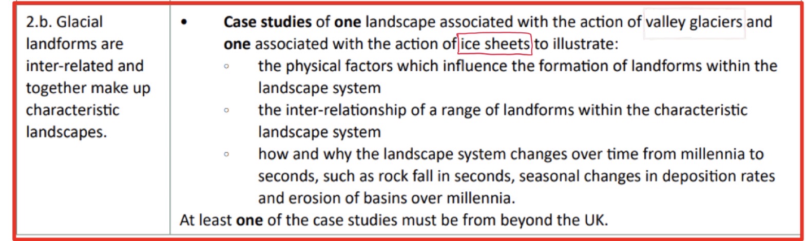
Physical factors influencing the formation of landforms within the landscape system- geology
Geology:
oldest rocks lie in alternating bends of volcanic sedimentary rocks in Northern part of state and much of the Minnesota river valley. Between these belts lie granitic rock materials.
Volcanic+ sedimentary rocks began formation 2500mil yrs ago- lava escaped through rifts in what used to be sea floor.
Gneisses (metamorphic granite, sedimentary rocks) been folded+ faulted to form mountainous areas in the north of Minnesota
Erosional impact of ice sheet, creating landforms
Erosional impact:
Laurentide ice sheet 1km thick in places, massive erosional impact
Wore down many mountains, highest peaks now between 500-700m
Eagle Mountains highest natural point in Minnesota at 701m
Erosional impact created ellipsoidal basin being created- containing many lakes such as Upper and Lower Red Lakes
Ellipsoidal basin deep in Arrowhead region- due to rock type in the area. Form through the deepening of less resistant sedimentary rocks. Earlier tectonic tilting of landscape exposed weaker shales- less resistant, lakes in this area lie deeply in eroded Shales.
Ellipsoidal basin, weight of ice so heavy- pushes down on land, fills with water. Large scale landform
Striations show direction of ice movement. Small scale landform. Slightly more resistant rock, gneiss and greenstone. Wisconsin driftless steeper hills and valleys (SE Minnesota)
Depositional impact creating landforms
glacial lobes:
Wadena lobe
advanced from NE Canada, reached just south of Minneapolis.
Red, sandy till from red sandstone and shales in N+ NE
first deposited Alexandra moraine forming drumlin fields over Otter tail, Wadena + Todd counties, also formed Itasca moraine
Rainy + superior lobes
last advance left course-textured till, fragments of basalts, granite, red sandstone, slate, greenstone.
Deposits found across NE half of Minnesota, as far south as Minneapolis + St Paul
Des Moines Lobe
deposited till that is tan coloured, clay rich and calcareous due to shale and limestone at its source in NE
In the SW Prairie Coteau is a terminal moraine
Many deposits more than 160m deep
Inter relationship of a range of landforms within the characteristic landscape system
Landforms created by different bands of rock
different rates of erosion. Sedimentary rock weaker so eroded faster. Created large ellipsoidal basins. Lakes found in ellipsoidal basins= Lake Superior
Mountain range to north of Minnesota eroded by ice sheet, whole of Minnesota has more of an even, lower relief
More varied landscape in the southern part of Minnesota (hills and valleys) because this is part of the Wisconsin driftless section which is high relief, and was not covered by ice
Proglacial lakes- lake which forms next to glacier as it is retreating. Lake Agassiz
Lobes from the ice sheet create till deposits- moraine, drumlins
How and why the landscape system changes over time
advance and retreat of Laurentide ice sheet in response to glacial and interglacial periods
Erosion of basins over millennia- long term, then filled with water to create deep lakes. These have been around for millions of years.
Striations occur as the ice sheet was moving, short term landforms
Seasonal changes in Depositional rates- climate: warmer climate= more meltwater, more lobes moved and deposited till. Different composition of land as lobes transport different types of rock, influences soil development