Unit 2: Orthophoto maps
1/3
There's no tags or description
Looks like no tags are added yet.
Name | Mastery | Learn | Test | Matching | Spaced | Call with Kai |
|---|
No analytics yet
Send a link to your students to track their progress
4 Terms
Orthophotos and Orthophoto maps
Orthophotos are made from vertical aerial photos
Orthophoto maps are made by adding map information to the orthophotos
They have contour lines placed over them to provide a sense of the height of the landscape
An orthophoto map is a combination of a map and a photo
An orthophoto map has a larger scale than a topographical map
Topographical - 1cm : 50 000cm
Orthophoto - 1cm : 10 000cm
Since 2008 a digital mapping camera has been used to make orthophoto
When this camera is flown over an area, the images are recorded and corrected for scale automaticaly
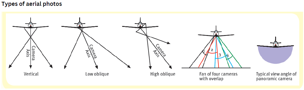
Vertical Aerial Photographs
Photographs captured from the air by a large camera that is fixed to the floor of an aeroplane which is flying directly over the photographed landscape.
The camera axis is vertical to the ground (90-degree angle).
Vertical aerial photographs show a top view of the landscape, its settlements, landforms and other features.
These photographs are usually filmed and printed in black and white to save costs, but they can also be filmed and printed in colour, electronically.
Vertical aerial photographs have a larger scale than topographic maps.
This means that features on these photographs are larger than map features.
Vertical aerial photography helps to map large and inaccessible areas.
Types of Vertical Photographs
Contour Lines on Orthophoto Maps
Orthophoto maps show a digitally changed image of the ground, as though every feature is seen from directly above
In reality, aerial photograph images captured by a camera are distorted or skewed by the lands shape and by the position of the camera
In addition to orthophoto images correcting the distortion they also provide height cues by having contour lines placed over the image