hydrogeology midterm 1
1/61
There's no tags or description
Looks like no tags are added yet.
Name | Mastery | Learn | Test | Matching | Spaced | Call with Kai |
|---|
No analytics yet
Send a link to your students to track their progress
62 Terms
aquifer
a geologic unit that stores and transmits water
aquitard
a geologic unit that doesn’t transmit water
saturated zone / phreatic zone
below water table, consists of water and rocks
water table
top of the saturated zones, surface in unconfined aquifer where pore pressure is atmospheric
confined aquifer
has impermeable boundaries
unconfined aquifer
top boundary is the water table
porosity (n)
ratio of volume of void space to total volume of rock/sediment
permeability (k)
measure of transmission property of rock/sediment and inter connectedness of pores - how easily the water moves through the aquifer
scale dependent
confining unit
geological unit of very low permeability that forms a barrier to groundwater flow
perched aquifer
An aquifer that is located above the main water table, separated by an impermeable layer. It holds water temporarily, often found in hills or elevated areas.
effective porosity
Effective Porosity: The measure of the interconnected void spaces in a rock or soil that can store and transmit fluids. It is the ratio of the volume of the void spaces to the total volume of the material. It determines the ability of a substance to hold and transport fluids, influencing groundwater flow and storage. (total volume excludes dead end pores)
true or false: can have the same total porosity but not the same connectivity or effective porosity
true
controls on inter granular porosity
Controls on intergranular porosity: Factors that influence the amount of space between individual grains in a rock or sediment. These factors include grain size, sorting, compaction (packing), and diagenesis.
controls on inter granular porosity: packing
The process of filling the space between particles in a geologic formation with fine-grained materials, such as clay or silt. This reduces the permeability of the formation, restricting the flow of water through the aquifer. Packing can affect the efficiency of water extraction wells and the movement of contaminants in groundwater.
controls on inter granular porosity: sorting
The process by which sediment particles are separated and classified based on their size and shape. It affects the permeability and porosity of aquifer materials, influencing the flow of groundwater. Well-sorted sediments have particles of similar size, while poorly-sorted sediments have a wide range of sizes.
controls on inter granular porosity: diagenesis
Process of physical and chemical changes that occur to sediment after deposition but before lithification. Involves compaction, cementation, and mineral alteration.
primary porosity
(inter granular) a function of grain size distribution and packing, tends to decreases with depth (weathering, compaction, pressure, diagenesis), at earths surface, tends to increase with decreasing grain size cause clay is fluffy and platy
secondary porosity
Secondary porosity refers to the additional pore spaces that form in rocks after their initial formation. It is created by various processes such as dissolution, fracturing, or deformation. Secondary porosity can enhance the permeability of rocks, allowing fluids to flow more easily through them.
specific yield
ratio of the volume of water a rock or soil will yield by gravity drainage to the total volume of the rock or soil
specific retention
ratio of the volume of water that remains in the soil when allowed to drain to the total volume of the soil
specific discharge or darcy velocity (q)
volume of discharge / unit of specific area - flux, not velocity
Q/A [L/t]
-K(dh/dL)
*not a velocity because it doesn’t account for the porosity of the rock (but called darcy’s velocity)
represents the volume of water that flows through a unit cross sectional area of pours media per unit time.
in the direction of decreasing h
independent of porosity
proportional to the change in hydraulic head given a fixed length of tubing (dL)
discharge or volumetric flux (Q)
volume of flow through a column [L3/t] - water volume moving through sand per unit time - volumetric flow rate
-K(dh/dl)A
hydraulic head (h)
the water level of tubes or wells -.
Hydraulic head (h): Measure of the potential energy of water in a system due to its elevation above a reference point. It determines the direction and rate of groundwater flow.
Z + (P/pg)
Z = elevation head
P/pg = pressure head (P = pressure, p = density)
seepage velocity (v)
actual velocity of water
takes into account the porosity
HIGHER than specific discharge because the water can only pass through the portion of the cross-sectional area that is connected pore space.
q/n = Q/nA
v > q
hydraulic conductivity (K)
a property of the rock and the fluid - fluid properties can change
(k)(p)(g)(u)
k = permeability (rock only)
p = fluid density
g = gravity
u = dynamic viscosity
transmissivity
how easily you can pump water out of an aquifer
Kb
b = aquifer thickness
how to estimate hydraulic conductivity:
permeameter test: do darcy’s experiment using a sediment sample
grain size analysis - empirical grain size relationships
elevation head
The pressure exerted by a column of water due to its height above a reference point. It determines the flow direction of groundwater and affects the movement of contaminants
h - pressure head
elevation - depth of piezometer
pressure head
The vertical distance from a reference point to the groundwater level in a well. It represents the potential energy of the water and is measured in units of length, such as meters or feet.
h - Z
depth of piezometer - depth of water
potentiometric surface
imaginary surface that connects water levels (h) in imaginary wells screened in the same aquifer
uncon: water table is ps
con: ps can be above the land surface (artesian well)
in absence of flow, surface is flat with no slope
a sloping surface indicates groundwater is flowing
the surface must be for a single aquifer
2D maps typically assume horizontal flow (equipotential lines are vertical)
head loss between adjacent contours is equal
equipotential line
lines old constant head
seepage face
the boundary between a saturated flow field and the atmosphere, or between a saturated flow field and a stream channel, where water is free to exit from the subsurface.
forms in unconfined aquifers cause P = Patm along the bank
elevation varies
h varies
so there’s flow that’s not perpendicular along the vertical bank
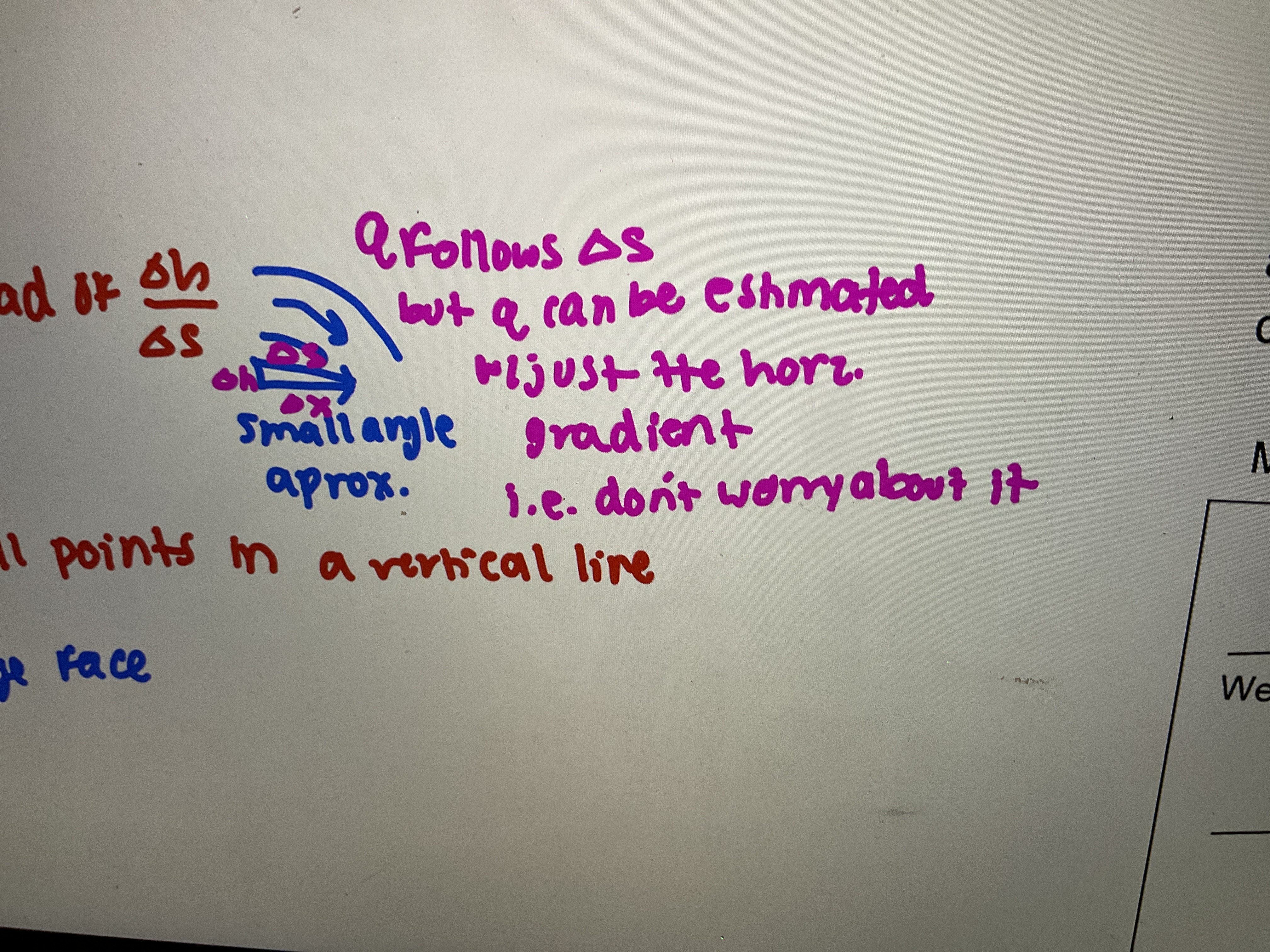
Dupuit assumptions
to know where water is at steady state use DA (for steady flow in uncon)
darcy velocity proportional to dh/dx and not dh/ds (small angle approximation)
horizontal flow
flow lines are horizontal and equipotential lines are vertical
hydraulic gradient equals the slope of the water table
flow is about the same at all points in a vertical line (ignores seepage face)
uncon - flow has to change as thickness changes (linear in h²)
homogeneous
hydraulic conductivity doesn’t vary in space
heterogeneous
hydraulic conductivity does vary in space (changes with location)
isotropic
hydraulic conductivity does not vary with direction
anisotropic
hydraulic conductivity does vary with direction
speak about how homo/hetero and ani/iso relationship works
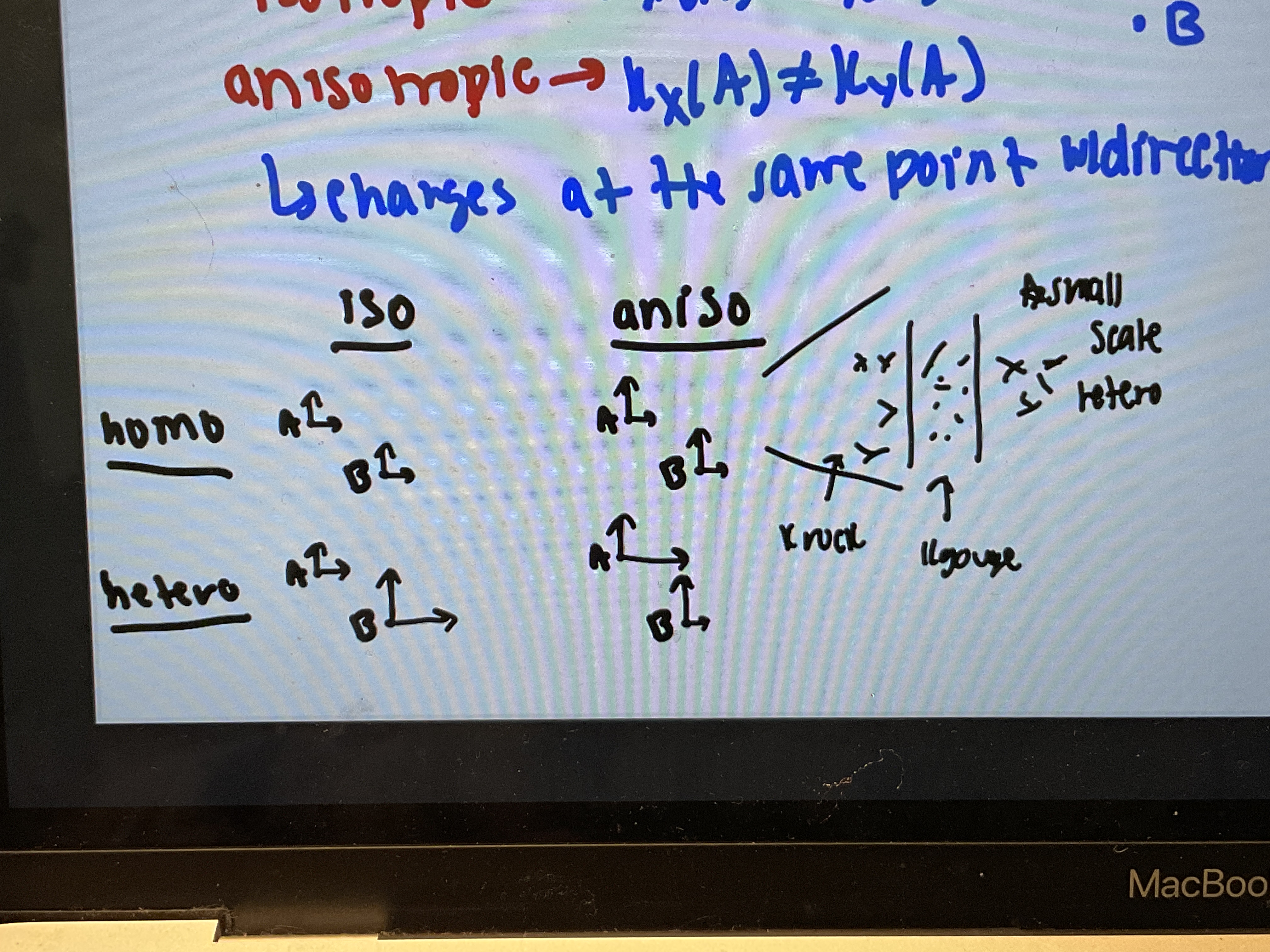
what causes heterogeneity
changes in lithology and aquifer thickness
what causes anisotropy
changes in grain shape/orientation, small scale heterogeneity, layering, preferred pathways
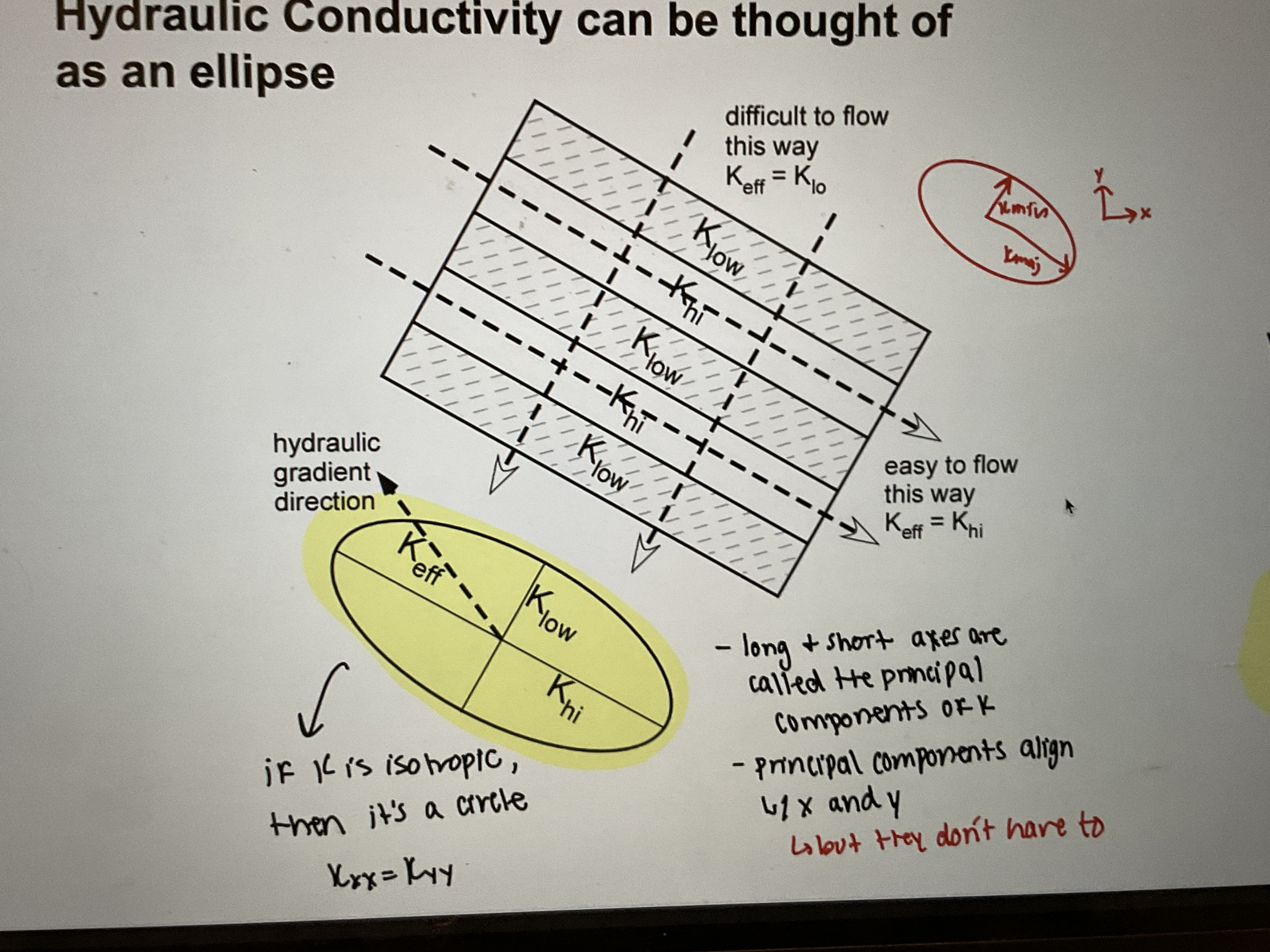
effective flow: which is easier, flow parallel to perfect layers or flow perpendicular to perfect layers?
perpendicular
effective properties for flow perpendicular
same Q
effective porosity for parallel flow
hydraulic gradient is the same for all of the layers
list important observations about effective permeability
layering (hetero) causes effective anisotropy (different K in each direction)
in general for any heterogeneity (random, not necessarily layered), effective K is usually somewhere between K harmonic (y dir) and K arithmetic (x dir) = K geometric
what does darcy’s velocity direction depend on in isotropic aquifers?
the hydraulic gradients in each direction. flow follows path of steepest descent and the opposite direction of hydraulic gradient
what does darcy’s velocity direction depend on in anisotropic aquifers?
magnitude of K and the hydraulic gradient in each direction. anisotropy can cause the direction of flow to be different than the direction of the hydraulic gradient
boundary condition: no flow
impermeable barrier, flow lines run parallel to barrier
contact with bedrock (horizontal) or flow divide (vertical)
boundary condition: constant head
head is a known, specified value along the boundary. implies an infinite source/sink of water. flow lines intersect boundary at right angle (boundary is an equipotential)
example: lake or river
boundary conditions: water table
only for unconfined aquifers (usually 2D vertical cores-section). boundary is not a flow line or an equipotential. head is known but variable along the boundary. if there is no other recharge/discharge, flow lines are parallel to the boundary, otherwise they are oblique.
flow net rules:
equipotentials are parallel and never intersect
flow lines are parallel and never intersect
in isotopic media, flow lines are perpendicular to equipotentials
for quantitative flow nets:
flow lines and equipotentials form curvilinear squares
streantubes must start and stop at constant head or water table boundaries
even if flow speeds up, it would still be constant between tubes
flow nets in heterogeneous systems;
use the same rules except with two exceptions:
at boundaries between layers, flow lines are refracted
for quantitative flow nets: curvilinear squares (with circles) can only be drawn in one layer - I choose the layer. usually easiest to do thickest layer
geologic processes that control regional flow:
topography: driven by K, heterogeneity, and basin geometry
free convection: circulation cells and buoyancy (driven by density gradients, quiver thickness, K, and heterogeneity
tectonic deformation: driven by strain rate, K, heat
rapid sedimentation: typical in young, low permeability basins with lots of sediments. fluid pressure can approach overburdening the weight of overlying sediments. geotechnical hazards
fault slip
general observations about groundwater flow systems:
local relief fives rise to local groundwater systems
increased depth:wide gives rise to intermediate groundwater flow systems (that surround local flow systems)
regional groundwater flow systems have recharge areas at the basin divide and discharge at the valley floor
three most important controlling factors for the flow system:
ratio of basin or aquifer depth to extent
configuration of the water table: magnitude of undulation affects the scale of flow systems
variations in hydraulic conductivity (geologic heterogeneity)
increases rugged terrain = decrease opportunity for regional flow systems
true or false: recharge area is usually much smaller than the discharge area
false
true or false: recharge tends to be relatively distributed in space and slower
true
Gin = Gout
Arqr = Adqd
Ar » Ad
qr « qd
losing stream
lose water to the aquifer - water table is below stream
gaining stream
receive water from the aquifer - water table is above the stream
groundwater-lake interactions: surface water dominated
water table is below the lake. the lake feeds the aquifer
groundwater-lake interactions: groundwater dominated
groundwater discharges into the lake and recharges it
springs
areas of natural discharge where the water table is at or very near the land surface
discharge can be permanent or ephemeral