East Asia to Sub-Saharan Africa Vocab and Concepts
1/21
There's no tags or description
Looks like no tags are added yet.
Name | Mastery | Learn | Test | Matching | Spaced | Call with Kai |
|---|
No analytics yet
Send a link to your students to track their progress
22 Terms
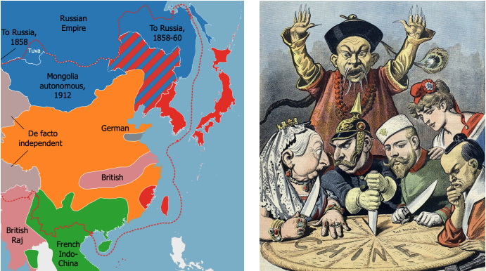
What does this cartoon and map represent?
The Century of Humiliation (1839-1849)
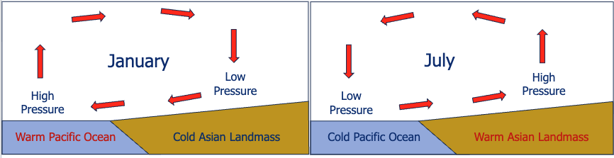
If winds are blowing as indicated, what season is it? If reversed
Summer if indicated, Winter if reversed.
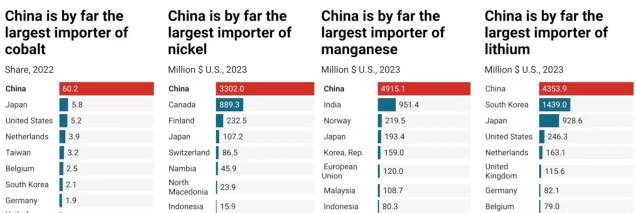
China is the largest importer of which 4 battery-essential elements?
Cobalt, nickel, manganese, lithium

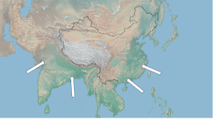
Why are the Not Dry regions Not Dry?
Orographic Rainfall / Monsoons
According to Helmut Kohl, what is the main benefit of European unity?
Peace — as Thomas Friedman put it, “considering Europe’s long history of fratricide, the EU is a quiet, boring miracle.”
Why is Europe so hard to unify?
Why was North Macedonia initially not allowed to join NATO?
Because Greece threw a hissy fit about the name “Macedonia",” since the northern part of Greece is “Macedon,” and the Greeks didn’t want what was then “Macedonia” to get any ideas. Also see transylvanian/hungarian irredentism
Is physical geography a centripetal or centrifugal force in Europe, and why?
Centrifugal: physical fragmentation with peninsula-ception, small navigable rivers, good harbors, and lots of small mountain ranges.
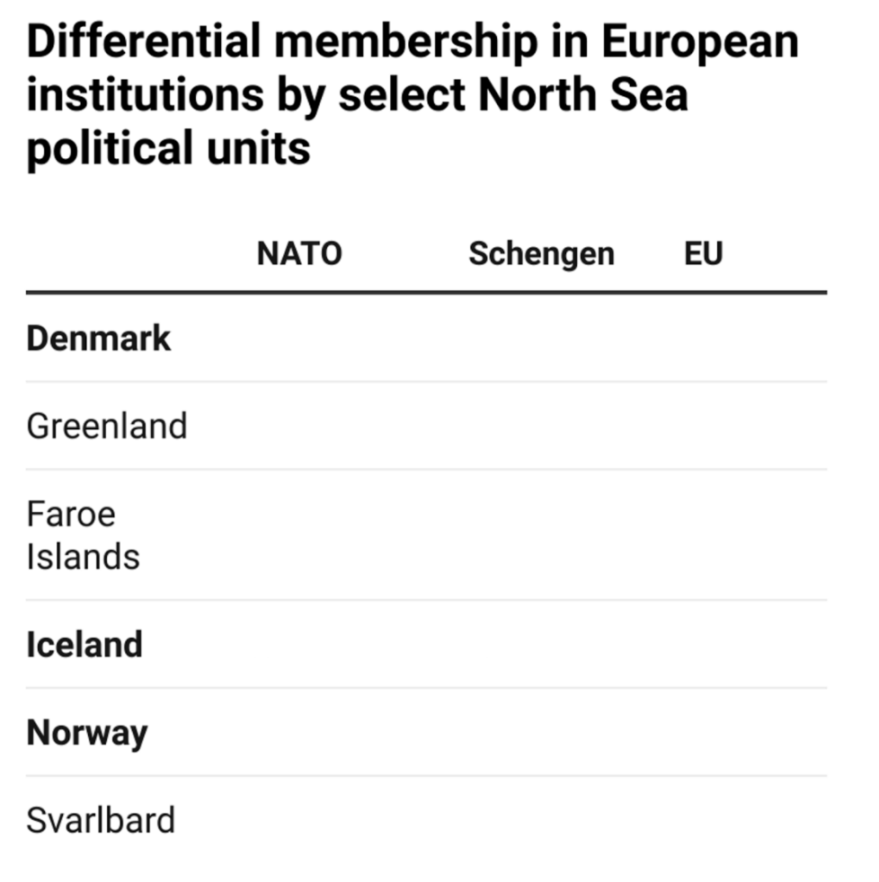
Fill out this diagram. Focus on what you know of each territory and their dependencies.
S
Strategic Depth
Distance from the border/frontline to heartlands, major industrial/agricultural/governmental areas.
Warsaw Pact Nations
Bulgaria, Czechoslovakia, GDR, Hungary, Poland, Romania, USSR
Russia’s advantage of being “landlocked”
Only large state that didn’t fall to a European power after 1500, because it was behind a set of natural barriers that discouraged invasion.

What should we take away from this map?
There is no simple explanation for anything, no simple dichotomy that illuminates a solution. You should be more confused than knowing what’s going on, because if you think you know what’s going on, you are almost certainly wrong.
Iraqi approach to State-Nation problem
Autocratic rule (Saddam)
Lebanese approach to State-Nation problem
Power sharing in the 1943 constitution
What is “orientalism,” and how is it related to “Middle East” or “Midwest?”
Said: Orientalism is thinking about a place from the perspective of another; looking at the world from outside, not inside.
Middle East: It was to the east of the Europeans who drew the map, and we call it the middle east now.
Midwest: Midwest because it’s the middle west as defined by the Eastern US.
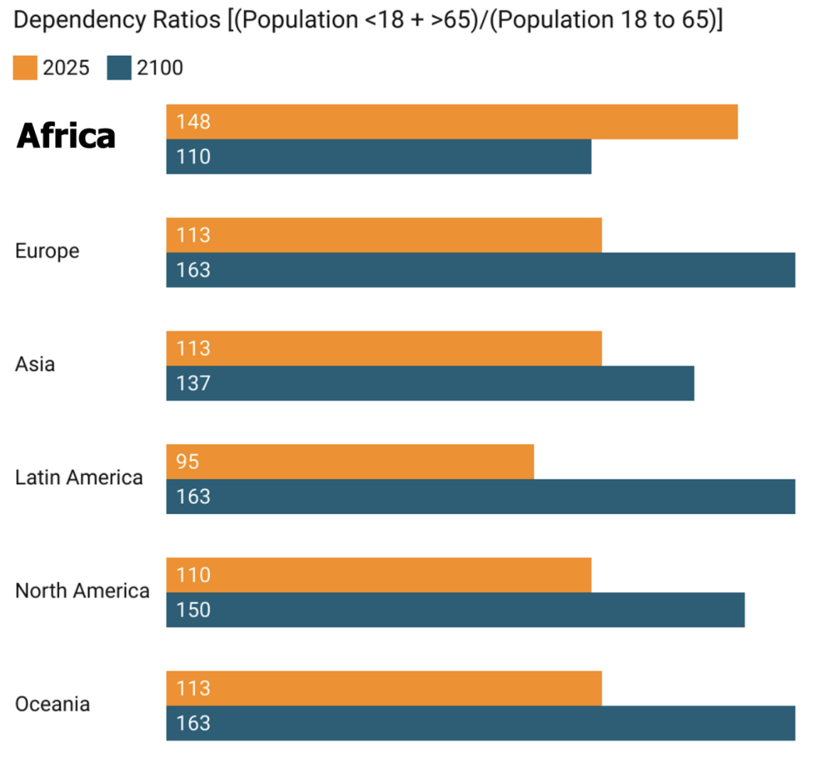
Why does this figure suggest an overall positive future for Africa?
Africa is the only region with a decreasing dependency ratio. By 2100, it will have ½ of the world’s working age population. This demographic transition is the only thing that ties all “miraculous” asian states together.
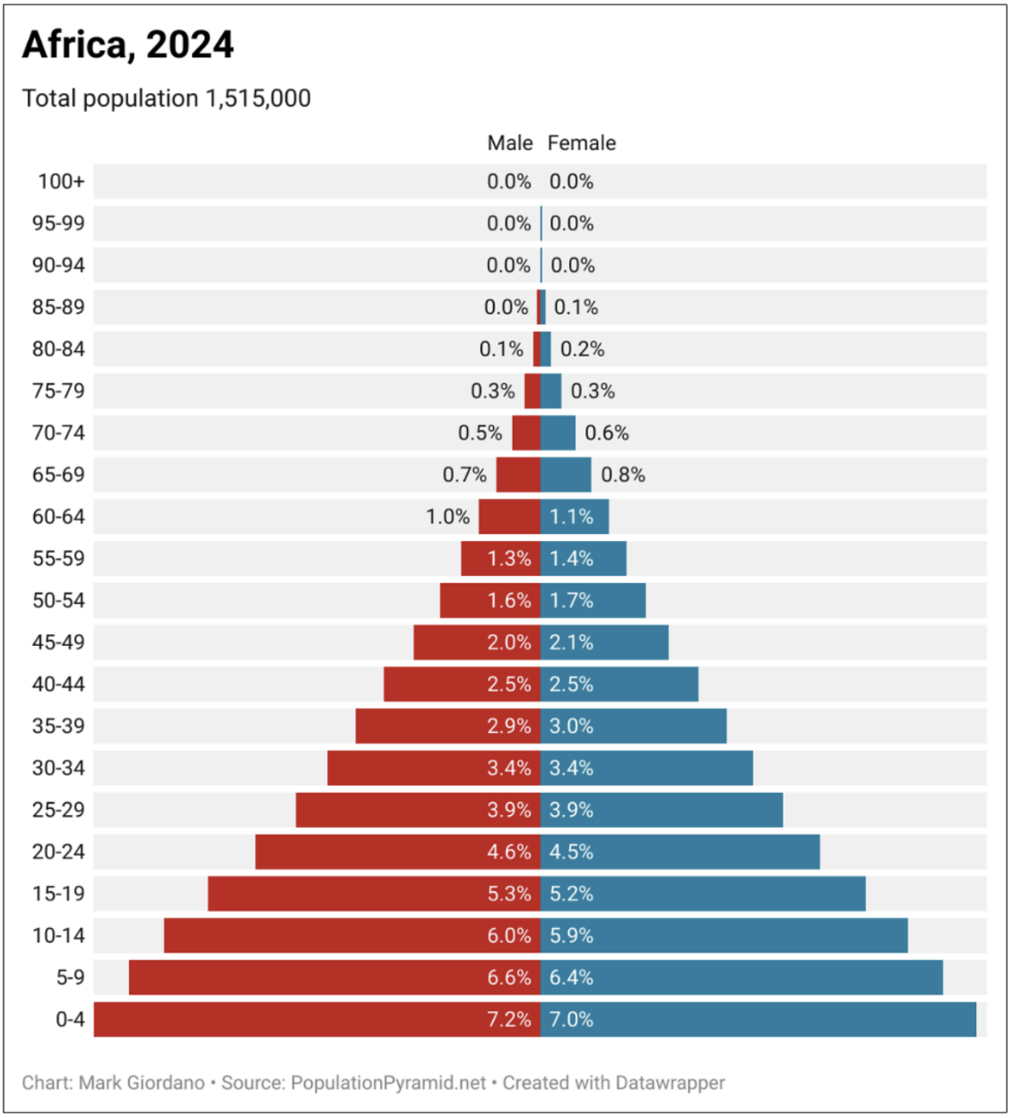
In the 1960s, what region of the world had population pyramids similar to this one?
Asia
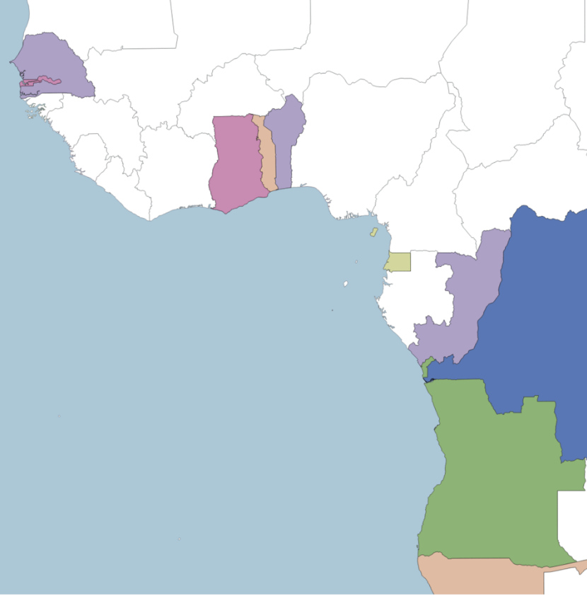
Why is this map screwed up? Answer with reference to Angola, Congo, Zaire/DRC, Togo, and Benin.
Portugal’s claim (Angola) cut into two pieces, because of intervening French (Congo) and Belgian (Zaire/DRC) claims to access to river heads. Togo (german) and Benin (French) each being narrow strips with access to the interior.
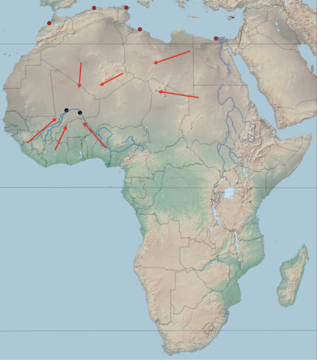
What 3 factors enabled the tendency towards internally oriented power?
Domestication of the camel, coastal escarpments limiting navigability of major rivers to oceans, immense size of continent.
What is the furthest limit of internal navigability for African rivers? (Within ___ km of the coast)
Within 300 km of coast
Exotic River (Definition and 1 example each from Africa and SWANA)
Rivers that move water from high rainfall areas to arid areas. Nile and Tigris/Euphrates.