year 9 plate tectonics
1/19
Earn XP
Description and Tags
note to self
Name | Mastery | Learn | Test | Matching | Spaced | Call with Kai |
|---|
No analytics yet
Send a link to your students to track their progress
20 Terms
recall structure of earth (DO THIS LATER)
in order, crust (5-70km), mantle (2850km thick), outer core (2200km) (liquid), inner core (1270km) (solid)
outline nature of lithosphere and asthenosphere and relationship to the layers of the Earth
Lithosphere:
The lithosphere is the rigid, outermost layer of the Earth, comprising the crust and the uppermost part of the mantle.
It is solid and brittle, meaning it can fracture or break under stress.
The lithosphere is divided into tectonic plates, which float and move on the underlying asthenosphere.
It varies in thickness but is typically about 100 km thick.
It is lower in density than molten magma therefore floating on top
Asthenosphere:
The asthenosphere lies beneath the lithosphere, within the upper mantle.
It consists of partially molten, ductile (plastic-like) rock that flows slowly under high temperature and pressure.
This flow enables convection currents, which drive the movement of tectonic plates above.
It begins at a depth of approximately 100–250 km and may extend down to 700 km beneath Earth’s surface.
Relationship to Earth's Layers:
Both the lithosphere and asthenosphere are part of the mantle, but differ in mechanical properties:
Lithosphere: rigid and brittle.
Asthenosphere: ductile and flowing.
Their interaction explains plate tectonics, earthquakes, and volcanic activity, linking surface phenomena to internal Earth processes.
describe wegeners’ theory of continental drift and evidence to support it
wegeners’ theory of continental drift states that the earth’s surface is composed of plates which are constantly moving, suggesting the existence of a Pangaea supercontinent drifting into our current continents.
Proofs:
1. Coastlines of certain continents eg South America and Africa fit together like a jigsaw puzzle.
2. Fossils of prehistoric landbased creatures on continents which are separated by oceans can be found on the different continents, suggesting that the landmasses must have been together as the animals could not swim.
3. Rock structures and types on different continents match each other eg Appalachian mountains in US and Scottish Highlands which have similar ages despite being separated by the sea
4. Coal found in cold areas- above arctic circle. But coal comes from decomposed plants, but it is far too cold in that area now for the plants to grow.
5. Ancient glaciers have left valleys and debris across many continents, including some now too warm to produce glaciers
6. as lava from volcanoes cool, it adopts the magnetism of the Earth at that moment. within south and north america, rocks three-hundred million years old have been found with different north and south pole directions. the continents appear to have shifted in such a way that now they are mismatched, but if continents are put together (like jigsaw) they point to a common north pole.
Decsribe theory of plate tectonics
The theory of plate tectonics states that the Earth's lithosphere is divided into several large and small tectonic plates that float on the semi-fluid asthenosphere beneath. These plates are in constant motion due to convection currents in the mantle. As a result, the plates are continually pushed, pulled, and stretched, leading to the formation of earthquakes, mountains, volcanoes, and mid-ocean ridges. Plate boundaries can be divergent, convergent, or transform, depending on the direction of movement.
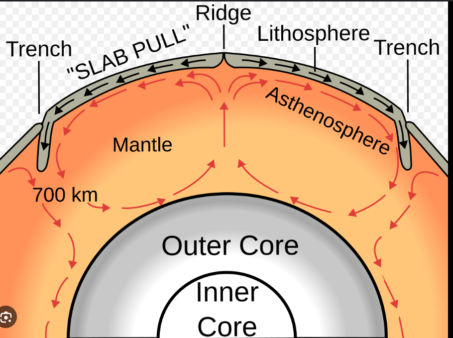
Describe movement of Earth’s plates to mantle convection currents and gravitational forces with diagrams
Convection currents due to heating up and cooling down in asthenosphere causes plates on the lithosphere to move, can cause subduction zones from two plates colliding and one sinks under. Gravity pulls the tectonic plate downwards (slab pulls). Diverging boundaries can cause ocean ridges to form new crust due to magma coming out and cooling down, forming new oceanic crust. Since mid ocean ridges are elevated, gravity pulls the new crust down and away from the ridge, pushing plates outwards.
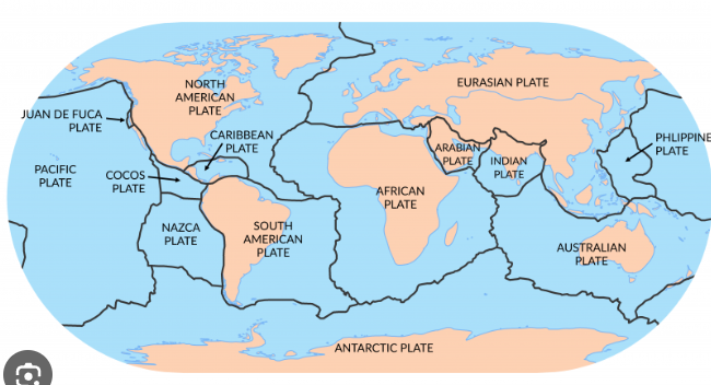
Identify major tectonic plates
Pacific, North American, South American, African, Eurasian, Indo-Australian, Antarctic.
Give two pieces of evidence for the theory of plate tectonics DO LATER
Theory of seafloor spreading, which can be seen at mid-Atlantic ridge, as magma arises from the ridge and forms new crust, it expands the sea floor from the ridge, moving continents along with it.
Continental drift.
Explain the idea of Pangaea and how the continents have reached their current positions
Pangaea was a supercontinent about 300m years ago that was composed of almost all the landmasses. it broke apart due to the mantle convection currents moving the tectonic plate, drifting them across the globe to their current positions over millions of years.
Explain the differences between transform, convergent and divergent boundaries and
identify one event in history that correlates to each boundary.
Plate boundaries are the regions where tectonic plates interact with each other, leading to specific geological processes depending on the direction of their movement.
transform boundaries are boundaries where two plates slide against each other, such as the San Andreas Fault, in the state of California in the US. It caused an earthquake in San Fran in 1906 which destroyed 80% of the city and killed more than 3k ppl.
Convergent plate boundaries are boundaries where two plates push towards each other, which has caused events such as the formation of the Himalayas (Indian plate collides with Eurasian plate)
Divergent boundaries are boundaries where two plates are pulling away from each other, casing east african rift, where the african plate is splitting apart.
Describe the three possibilities for collisions of plates along converging boundaries and
the different geological features and natural events that occur there.
Three possibilities are oceanic x continental which causes the denser oceanic plate to sink below the lighter continental plate, causing a subduction zone and deep oceanic trenches and volcanic mountain ranges.
Oceanic x Oceanic, the denser or faster plate if density is the same will subduct causing deep ocean trenches, volcanic island arcs oceanic volcanoes.
Continental x continental crust, both are not dense enough to subduct, therefore they crumple and fold under the pressure, causing mountain ranges such as Himalayas, high plateaus and earthquakes.
Relate boundaries to new landforms such as folds (syncline, anticline), faults (reverse, normal, block mountain, rift valley), mid-ocean ridges, trenches, mountain chains, island arcs and volcanoes.
A fold is a bend in the rocks layers caused by compression. Happens when stress squeezes a rock, but they bend instead of breaking. Two types : Anticline and Syncline.
anticline=:( type bending
syncline=:) type bending
Faults are breaks or cracks in Earth’s crust where rock has moved. Happens when there is too much stress and rocks fracture. The rocks slide across fault line. Typically are found at transform boundaries. Three types of faults. Normal where rock above the fault moves downwards due to tension. Reverse where rock above fault moves upwards due to compression and strike-slip when rocks slide horizontally across each other.
island arcs chain of islands that form from volcanic activity due to subduction zone.
Explain how volcanic eruptions and earthquakes occur
Volcanic eruptions occur when buildup of pressure of magma is too much, causing it to explode in an eruption through vents on the Earth’s surface.
Earthquakes occur when tectonic plates that are sliding past each other lock up and jam. The pressure between the plates builds up, until the rocks break, causing the plate to jolt free, causing a vibration on the surface.
Explain the formation of a tsunami by an undersea earthquake
displacement of water causing waves etc
Predict possible outcomes for the Earth’s continents if they continue to drift
pangea proxima, within the next 250m years another supercontinent may form.
Define epicentre and focus of earthquakes
The point inside the Earth’s crust where the earthquake originates — where the rocks first break and movement begins.
The epicentre is the point on the Earth’s surface directly above the focus.
Describe types of seismic waves P, S and L compare their properties
Body waves (travel through body of earth) - Primary waves (P) move fastest, and are 1st to be recorded by seismic stations. they are able to travel through rock and magma, and subjects rock to alternating push and pull motion.
Secondary waves (S) move slower, and are recorded next. They only travel through solid rock, and are blocked by molten rock. It hits the surface with a shaking/side-to-side motion.
Surface waves (on surface of earth)-Love waves (L) fastest surface waves and have a side-to-side motion, caused when secondary waves hit the surface.
Rayleigh waves (R) are rolling waves, slowest but often largest and most destructive, caused by the wave interactions at surface from P and S waves.
Find epicentre of earthquake using time difference between P and S waves
Distance=(time in arrival difference x the speeds multiplied)/difference of velocities
Outline methods used to measure EQ intensity inc Mercalli Scale and Richter Scale
Richter Scale is a logarithmic scale to quantify the energy released during an earthquake. Since it is logarithmic, a whole number increase represents a tenfold increase in amplitude of seismic waves and rougly a 31.6fold increase in energy released.
The Mercalli scale evaluates the intensity in terms of effect on earthquake on surface. Rankings from I-XIIare based on observed effects. In the modified mercalli commonly used today, the lower numbers generally indicate earthquakes which are felt by people, while higher numbers are based off observed structural damage.
Describe some impacts of natural events, including cyclones, volcanic eruptions or earthquakes, on the Earth’s atmosphere
Volcanic eruptions - ash and gases (eg sulfur dioxide) are released into atmosphere, which can lead to short-term cooling due to the ash and aerosols clouds that can form reflecting sunlight, which can influence the climate.
Earthquakes - Destruction of the natural environment can result in the release of gases such as carbon dioxide from the Earth into the atmosphere, contributing to greenhouse effect. Destruction of infrastructure could lead to fires.