Oceans
1/48
There's no tags or description
Looks like no tags are added yet.
Name | Mastery | Learn | Test | Matching | Spaced | Call with Kai |
|---|
No analytics yet
Send a link to your students to track their progress
49 Terms
Ocean Basins and Ocean Water
Seawater covers 70.8% of Earth’s surface
Land comprising the remaining 29.2% is unevenly distributed between the northern and southern hemispheres
Most of the water is contained in three interconnected basins; Pacific, Atlantic and Indian Oceans that, along with the Southern Ocean, make up the “world ocean”
Measuring bathymetry
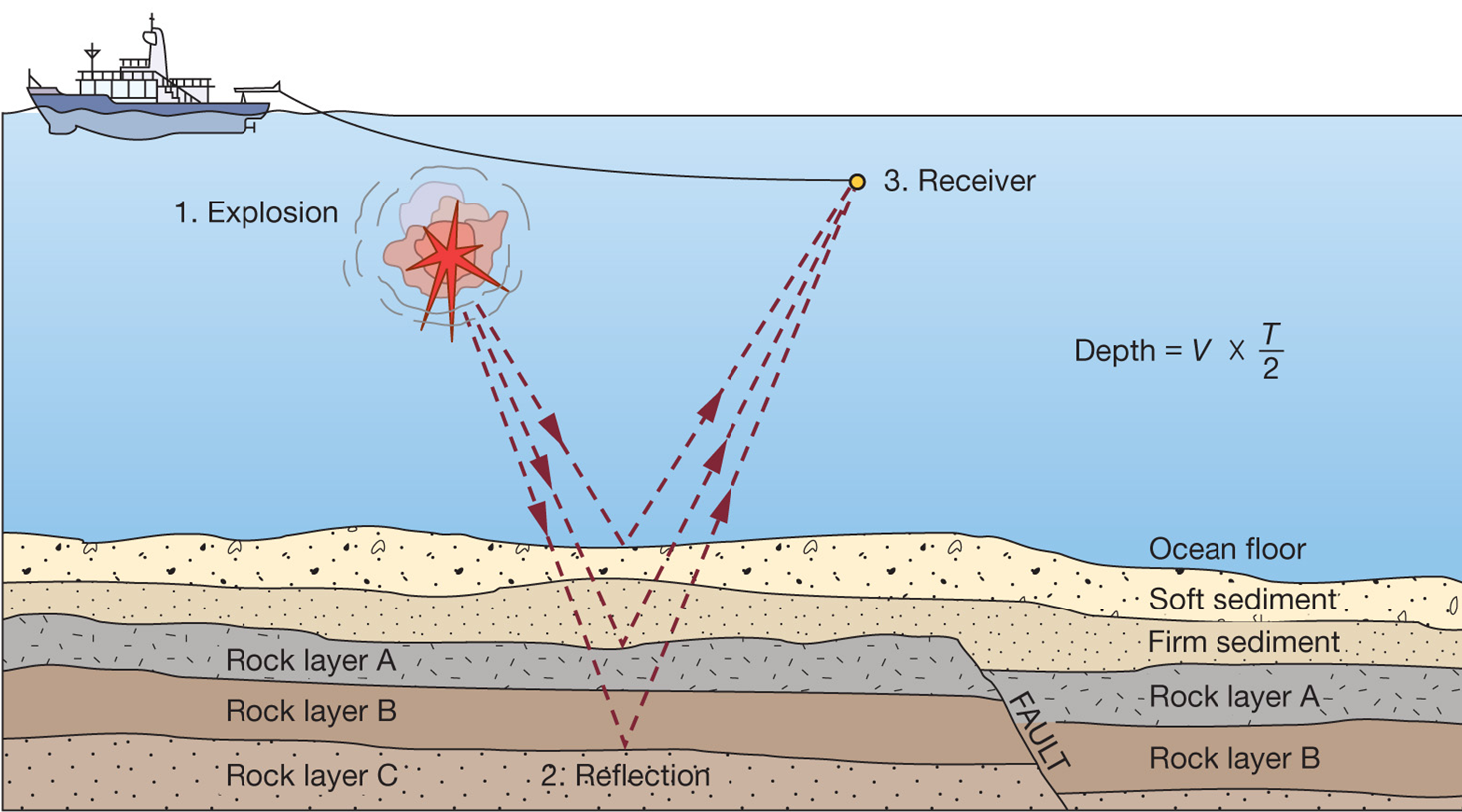
Ocean depths and topography of ocean floor
Sounding:
-Rope/wire with heavy weight
-Known as lead lining
Echo sounding:
-Reflection of sound signals
-1925 German ship Meteor
Measuring bathymetry
Precision depth recorder (PDR) 1950s
-Focused beam
Multibeam echo sounders
Side-scan sonar
Seismic reflection profiles looks at ocean structure beneath sea floor
Thanks to echo sounders, the topography of the seafloor and depth of overlying water are known in great detail for most of the ocean basins
-The Mariana Trench near Guam is the greatest ocean depth measured at 10,924 m
Recent satellite measurements reveal the average depth of the sea is 3970 m, and the average height of land above sea level is 840 m
Ocean Basins and Ocean Water
As far back as the oldest sedimentary rocks, more than 4 Ga, Earth has had liquid water on its surface
-Oxygen isotopes in zircons suggest that the ocean may be 4.4 billion years old
Where the water came from is still uncertain
-Carbonaceous chondrites contain water as hydrous minerals, suggesting some water originated from accretion and volcanic steam
-Icy comets bombarded early Earth, bringing with them frozen water
Ocean Water
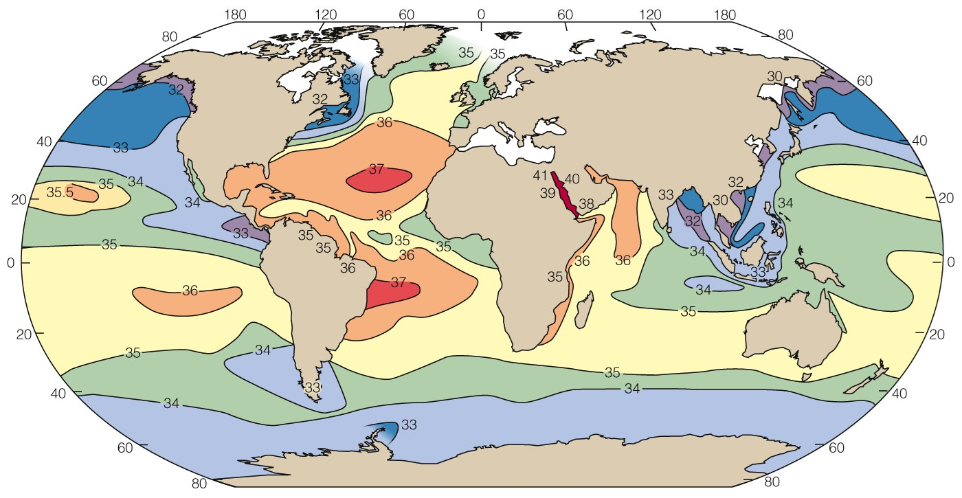
About 3.5% of average seawater consists of dissolved salts
-If these precipitated, they would form a layer about 56 m thick on the seafloor
Average salinity is 33 to 37 per mil
-Principally sodium, chlorine and six other ions derived from
→Dissolved load in streams
→Volcanic volatiles carried by atmospheric water
→Submarine volcanism
→Aeolian dust
→Pollutants
Ocean Salinity
Salinity of ocean water is related to latitude, but also…
-Evaporation
-Precipitation of rain and snow
-Inflow of fresh river water
-Freezing of sea ice
Stratification of the Oceans
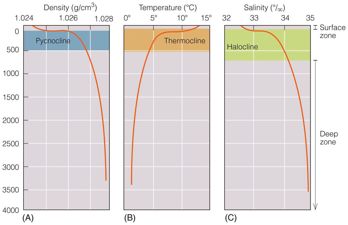
Physical properties of seawater vary with depth: ocean is vertically stratified
-Seawater becomes denser as temperature decreases and as salinity increases
-Gravity pulls denser water down
-Drives deep ocean circulation
-Three major depth zones
→Surface zone: 100-500 m (mixed layer)
→Thermocline, halocline or pynocline
→Deep zone: contains 80% of ocean water
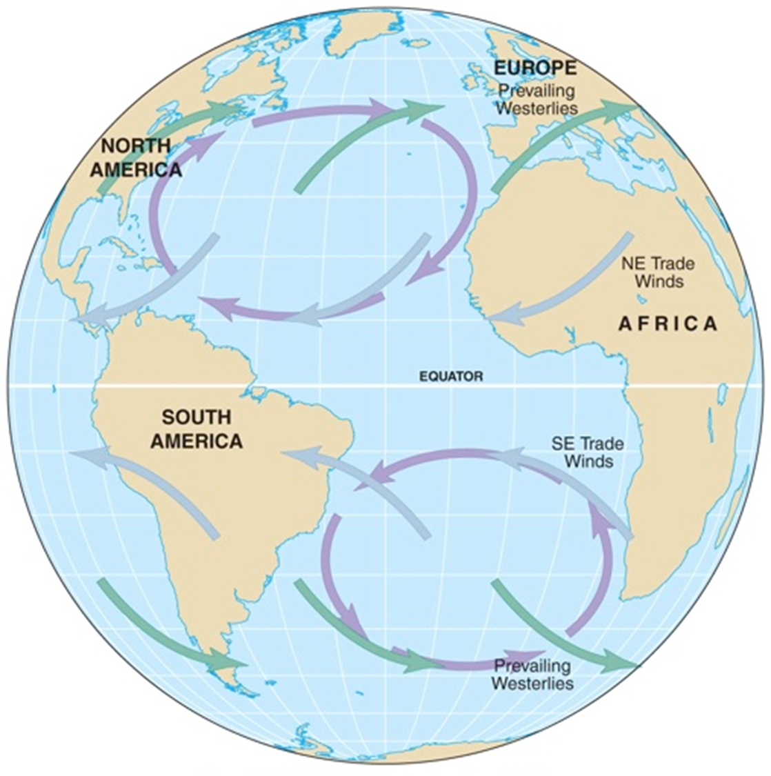
Ocean Gyres and Important Currents
•Each major ocean current is part of a large subcircular current system called a gyre
•On either side of the equator, ocean regions are dominated by westward-flowing North and South Equatorial currents
•Along the equator is the eastward-flowing Equatorial Countercurrent
•Near 60˚ latitude, the Antarctic Circumpolar Current circles the globe
Ocean gyres
Subtropical gyres
-Centered about 30o N or S
Equatorial current
Western Boundary currents
Northern or Southern Boundary currents
Eastern Boundary currents
Geostrophic flow
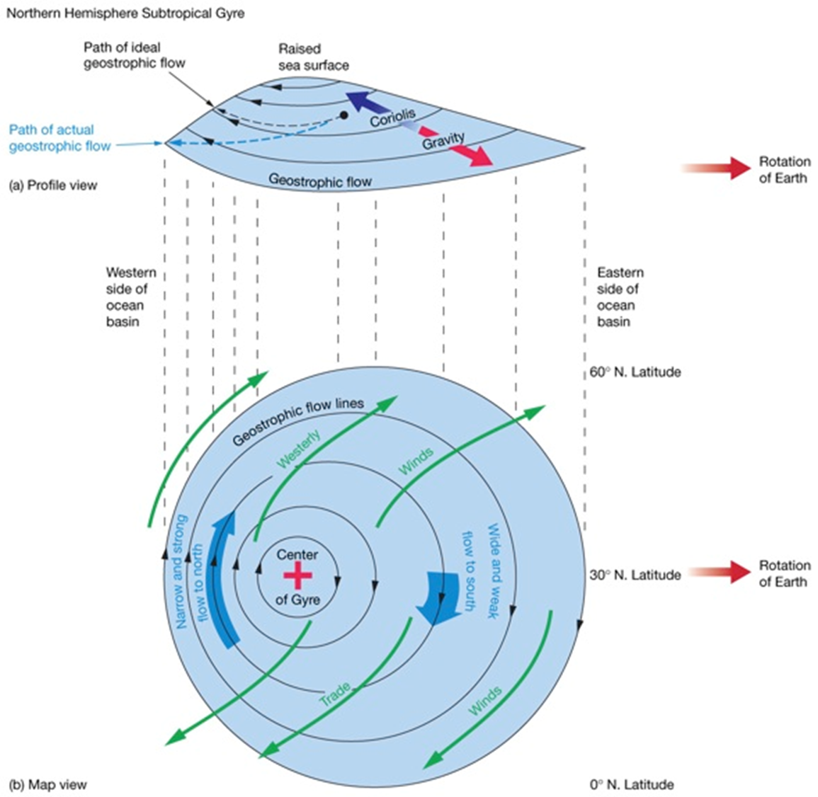
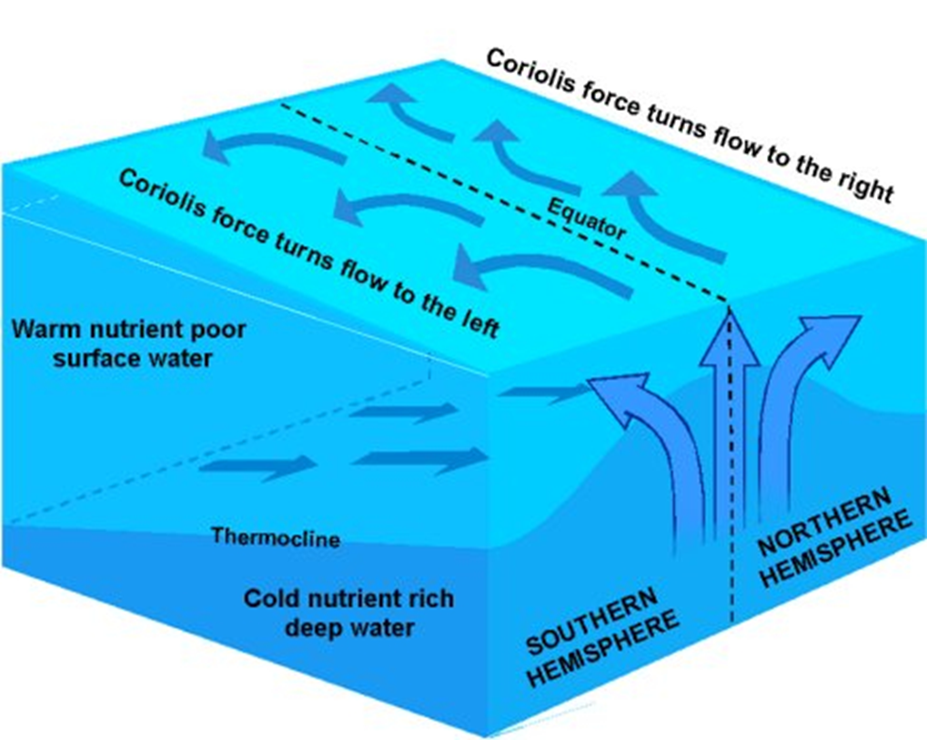
•Ekman transport piles up water within subtropical gyres
•Surface water flows downhill (gravity) and
•Also to the right (Coriolis effect)
•Balance of downhill and to the right causes geostrophic flow around the “hill”
•Top of hill of water displaced toward west due to Earth’s rotation
Converging surface seawater
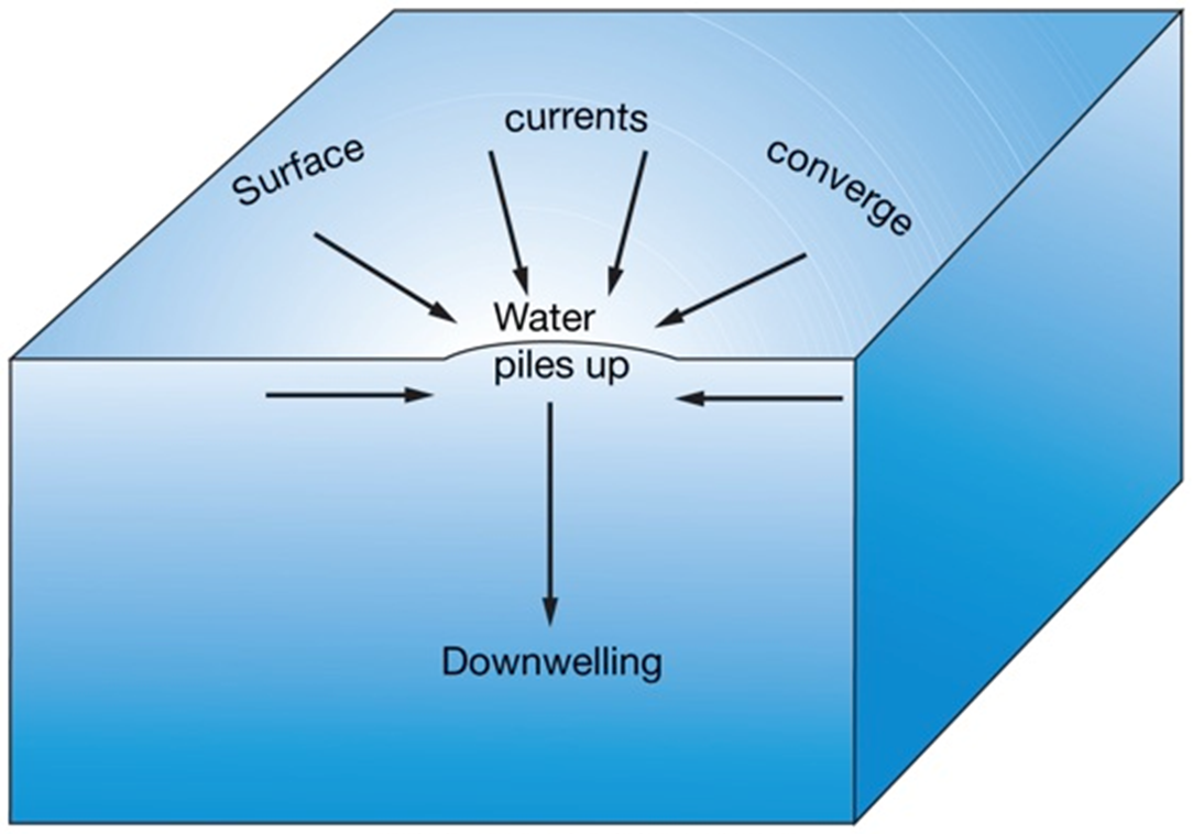
•Surface seawater moves towards an area
•Surface seawater piles up
•Seawater moves downward
•Downwelling
•Low biological productivity
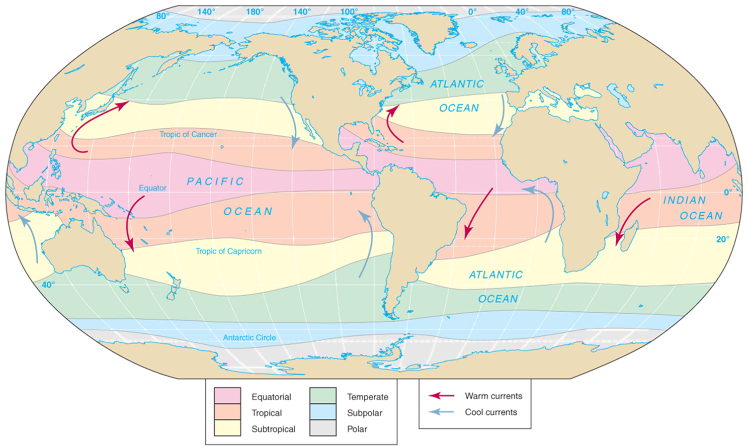
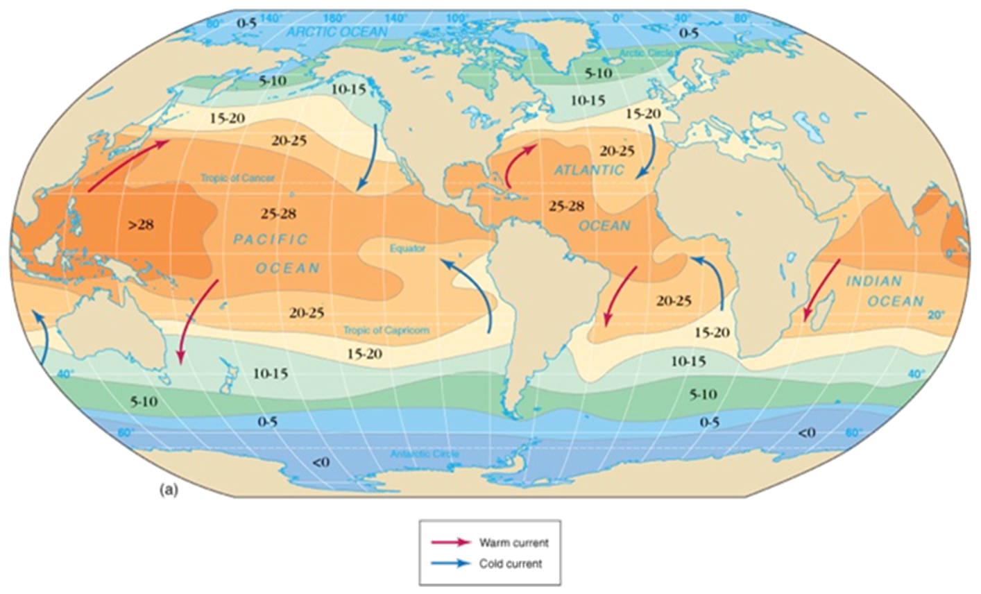
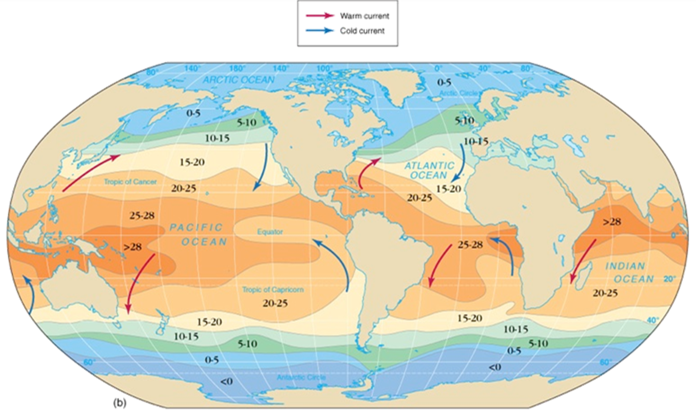
Map Of Cold & Hot Currents
Western & Eastern Boundary Currents
Western Boundary Currents:
Western side of ocean basins
Western boundary currents intensified
→Faster
→Narrower
→Deeper
→Warm
Eastern Boundary Currents:
Eastern side of ocean basins
Tend to have the opposite properties of Western Currents
→Cold
→Slow
→Shallow
→Wide
Map Of Ocean Currents

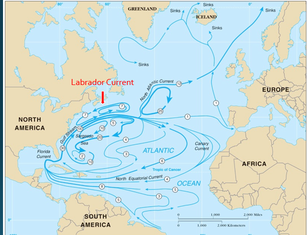
Gulf Stream- 7 to 30
N. Atlantic Current: By 25 and under 12
N. Equatorial Current: Under 6
Labrador Current: Current above 7
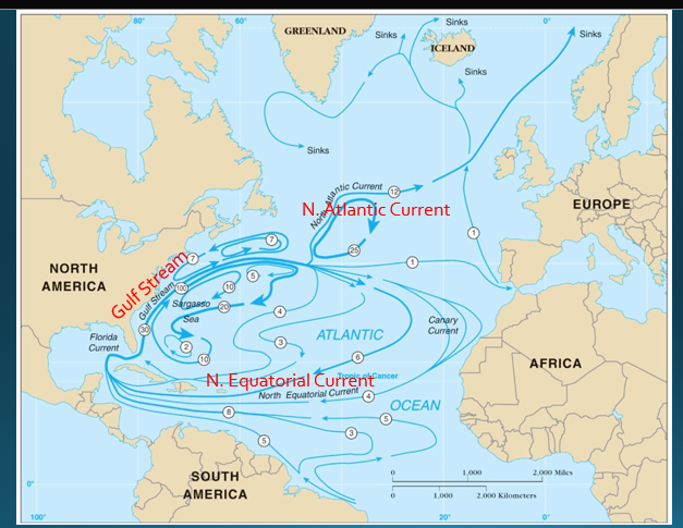
Atlantic Ocean circulation
North Atlantic Subtropical Gyre
North Equatorial Current – a continuation of which moves along the equator westward from Africa
Gulf Stream – extends out of the Gulf of Mexico and joins the North Pacific gyre
North Atlantic Current – extension of the Gulf Stream – we consider them one and the same for this course
-Canary Current
-South Equatorial Current
-Atlantic Equatorial Counter Current
The Gulf Stream (In the Past)
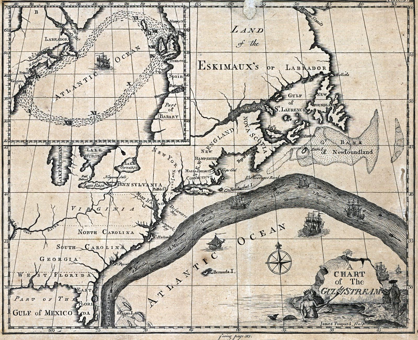
Gulf Stream
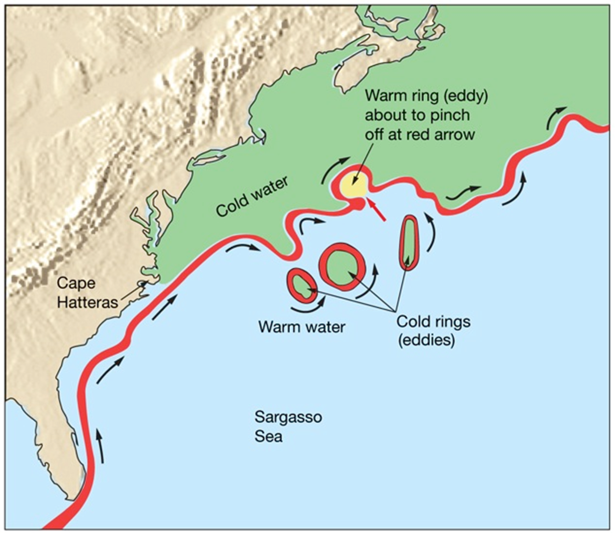
•Best studied
•Meanders or loops
•Warm eddies
•Cold eddies
•Unique biological populations
Effects of North Atlantic currents on climate
•Gulf Stream warms East coast of U.S. and Northern Europe
•North Atlantic and Norwegian Currents warm northwestern Europe
•Labrador Current cools eastern Canada
Antarctic circulation
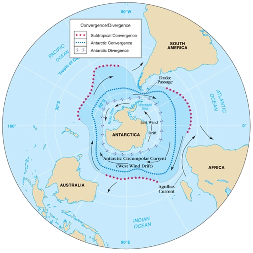
•Antarctic Circumpolar Current (West Wind Drift)
•Encircles Earth
•Transports more water than any other current
•East Wind Drift
•Antarctic Divergence
•Antarctic Convergence
Indian Ocean Circulation (Photo)

Pacific Ocean Circulation
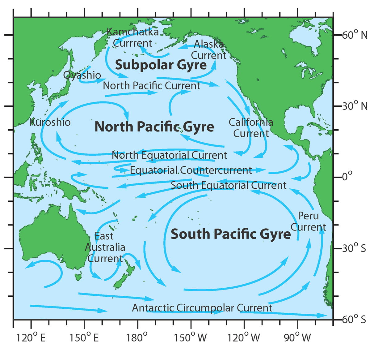
•North Pacific subtropical gyre
•Kuroshio
•North Pacific Current
•California Current
•North Equatorial Current
•Alaskan Current
•South Pacific subtropical gyre
•East Australian Current
•Antarctic Circumpolar Current
•Peru Current
•South Equatorial Current
•Equatorial Counter Current
Diverging surface seawater
•Surface seawater moves away
•Deeper seawater (cooler, nutrient-rich) replaces surface water
•Upwelling
•High biological productivity
Peru Example With Upwelling
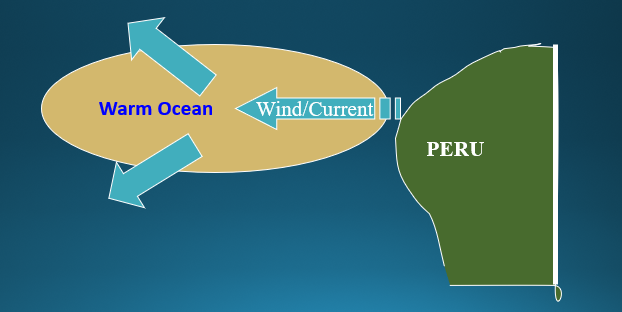
Warm ocean water bulges; driven by cold water upwelling. Bulge drives divergence.
Water moves northward and southward off the bulge
Upwelling
•Slice into ocean bulge showing trough formed by divergent currents
•Trough is associated with upwelling
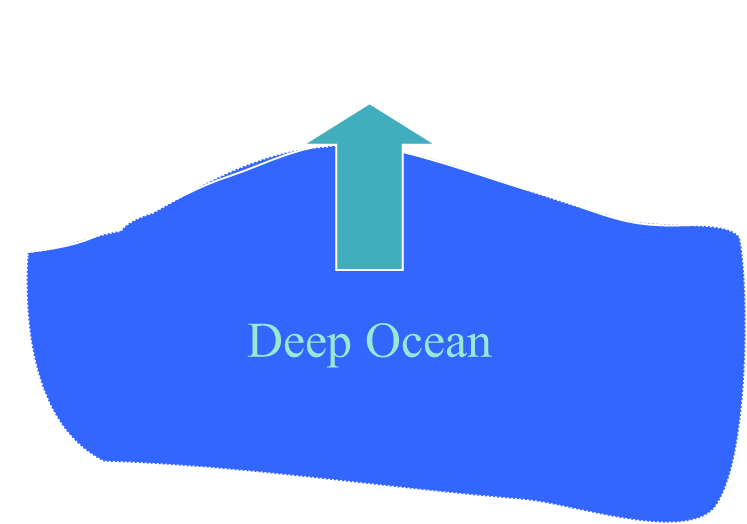
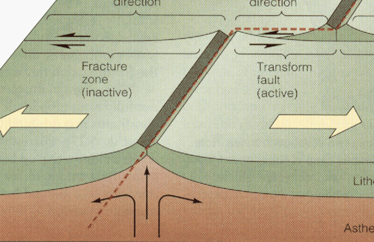
Rift/Fracture Zone
Regional Wind and Weather Systems
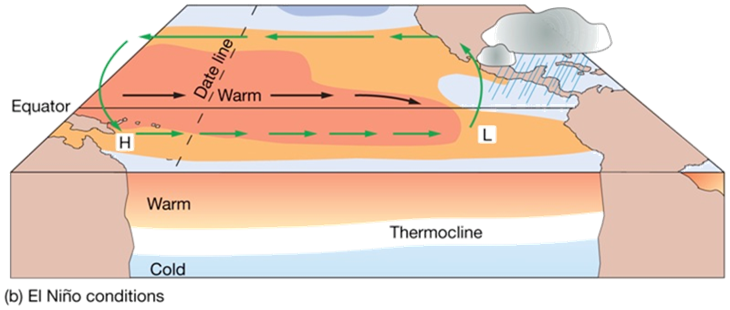
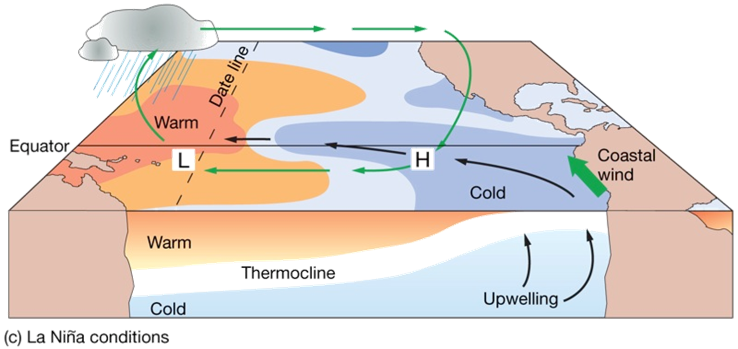
El Niño and the Southern Oscillation(change back and forth, it refers to atmospheric pressure changes)
•Off the coast of Peru, cold upwelling sustains fishing grounds with nutrients
•Periodically a mass of unusually warm water appears off the coast, when this happens, the trade winds slacken, upwelling is reduced, fish population declines and coastal birds die off
•Dry parts of Peru receive heavy rains, Australia experiences drought conditions, and cyclones appear in Hawaii and French Polynesia
Normal conditions
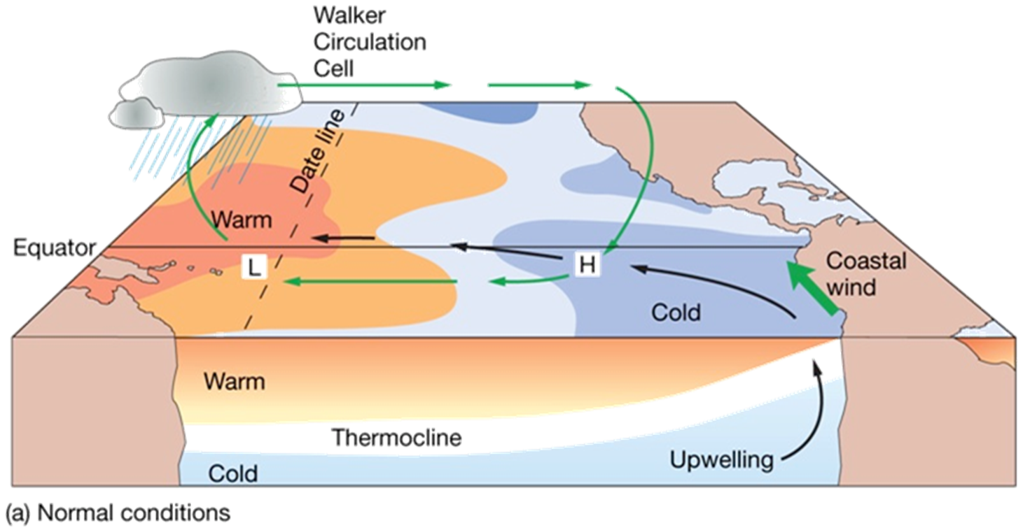
Normal Conditions:
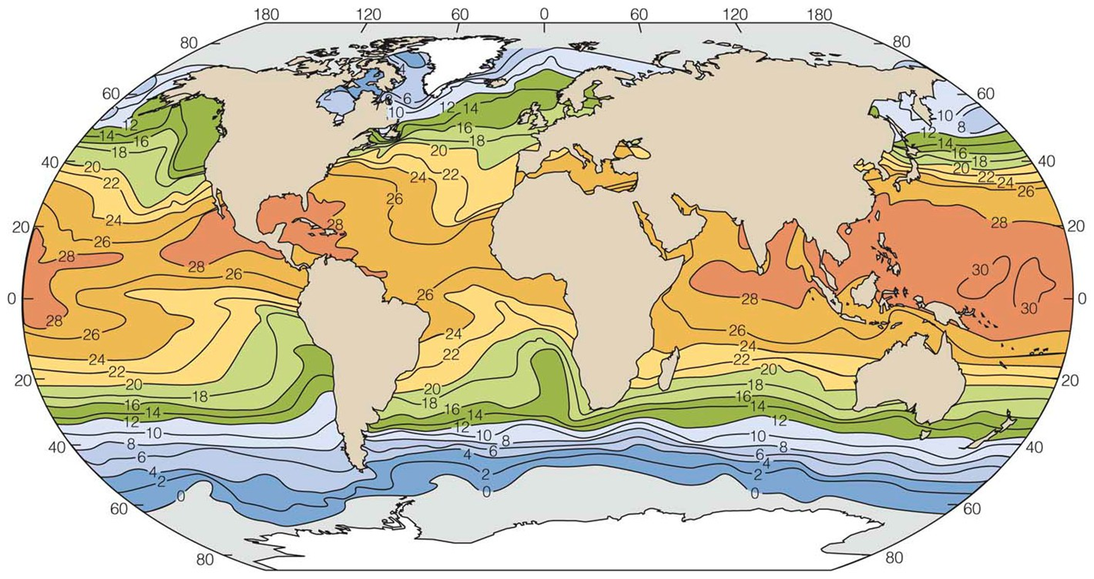
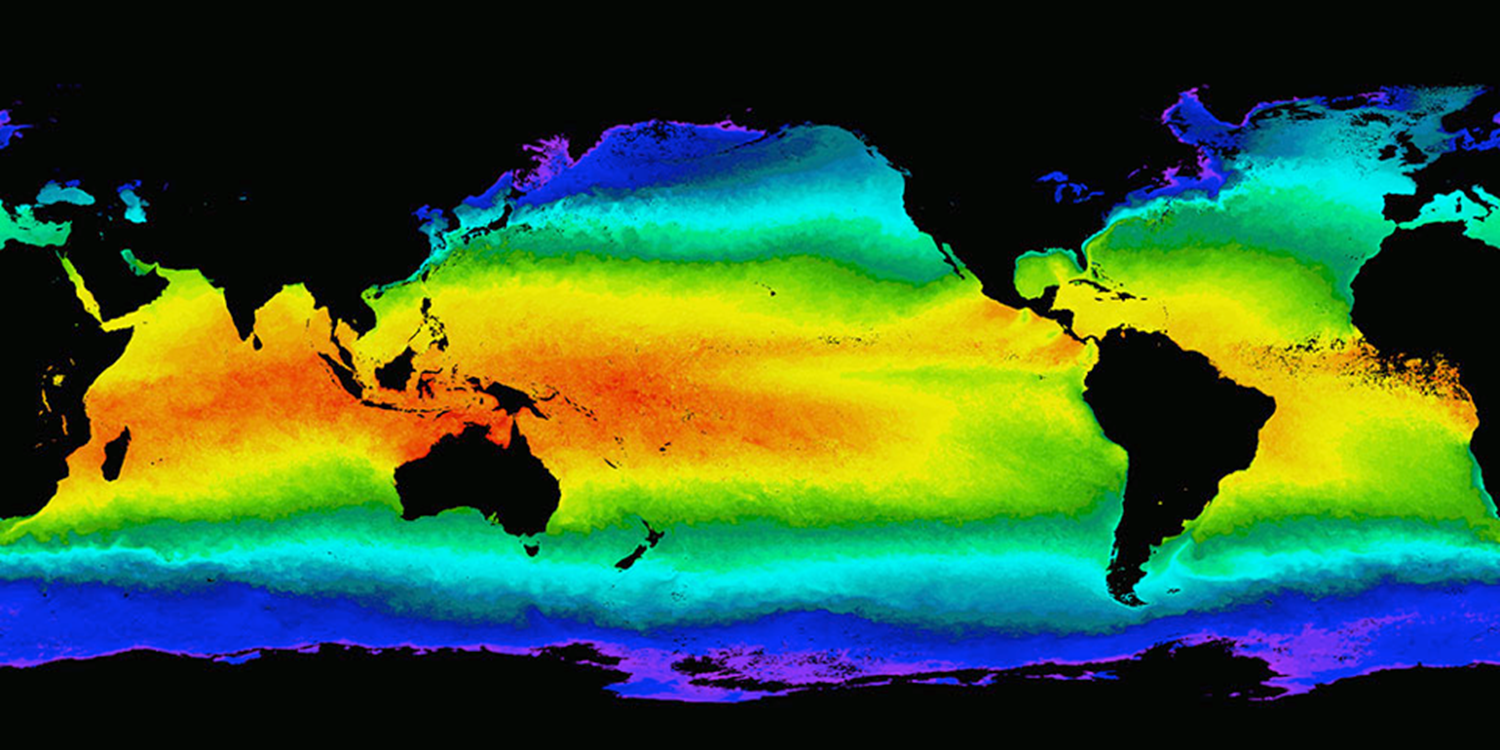
Sea Surface Temperatures
El Niño-Southern Oscillation (ENSO): Warm phase (El Niño)
El Niño-Southern Oscillation (ENSO)
Cool phase (La Niña)
El Niño and La Niña and the Southern Oscillation
Southern oscillation: This is the seesaw pattern of atmospheric pressure between the eastern and western Pacific. Winds are the link between pressure changes and the ocean warming and cooling associated with El Niño and La Niña.
Normal conditions
•Air pressure across equatorial Pacific is higher in eastern Pacific
•Strong southeast trade winds
•Pacific warm pool on western side
•Thermocline deeper on western side
•Upwelling off the coast of Peru
El Niño (warm phase):
El Niño (warm phase):
•Low atmospheric pressure in the eastern Pacific, slack tradewinds, upwelling ceases, deeper thermocline, warmer than normal seawater, low biological productivity.
La Niña (cool phase):
La Niña (cool phase):
•Increased pressure difference across equatorial Pacific, stronger trade winds, stronger upwelling in eastern Pacific, shallower thermocline, cooler than normal seawater, higher biological productivity
ENSO events
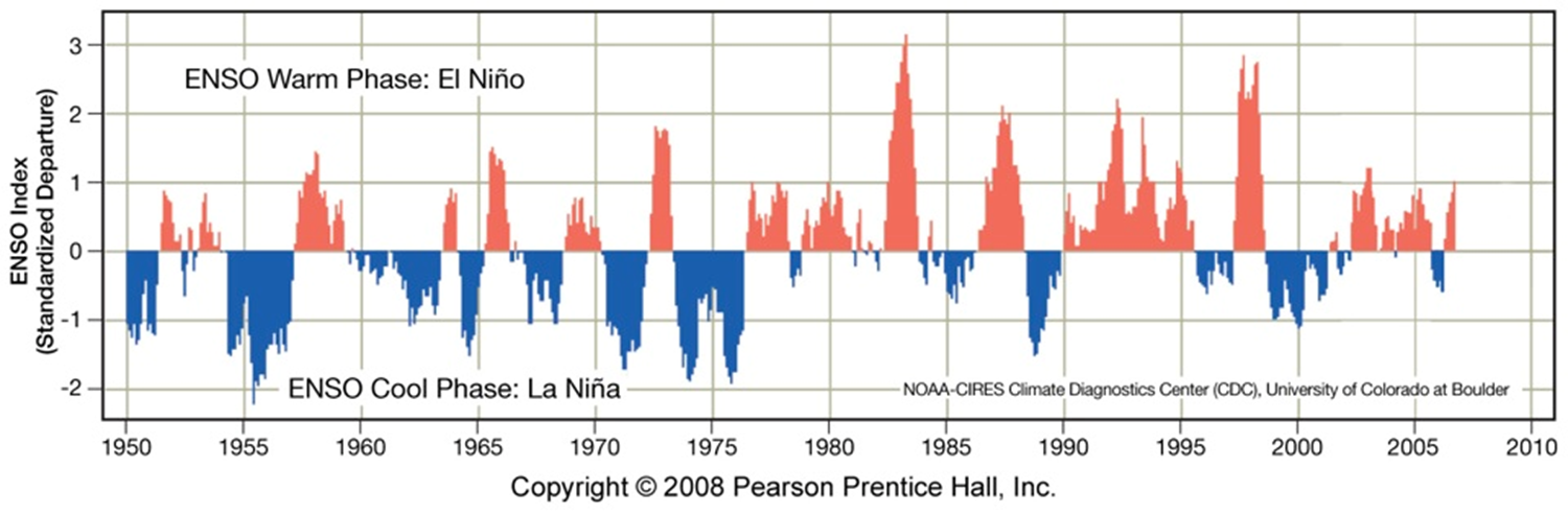
•El Niño warm phase about every 2 to 10 years
•Highly irregular
•Phases usually last 12 to 18 months
ENSO events
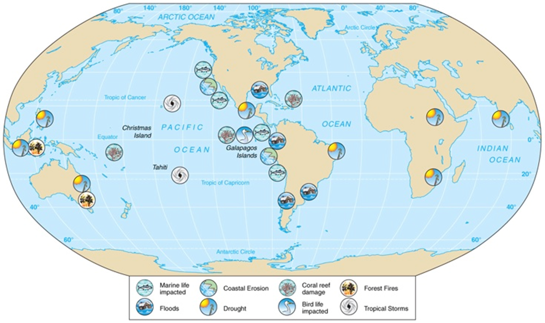
•Strong conditions influence global weather, e.g., 1982-1983 El Niño
•Flooding, drought, erosion, fires, tropical storms, harmful effects on marine life
Upwelling
Upwelling can occur due to
-Ekman transport
-Surface divergence
-Rising of deep ocean current to the surface
Upwelling brings nutrients (Nitrogen, Phosphorous and Carbon) up from the deep ocean – necessary to sustain marine life.
Deep Water Circulation
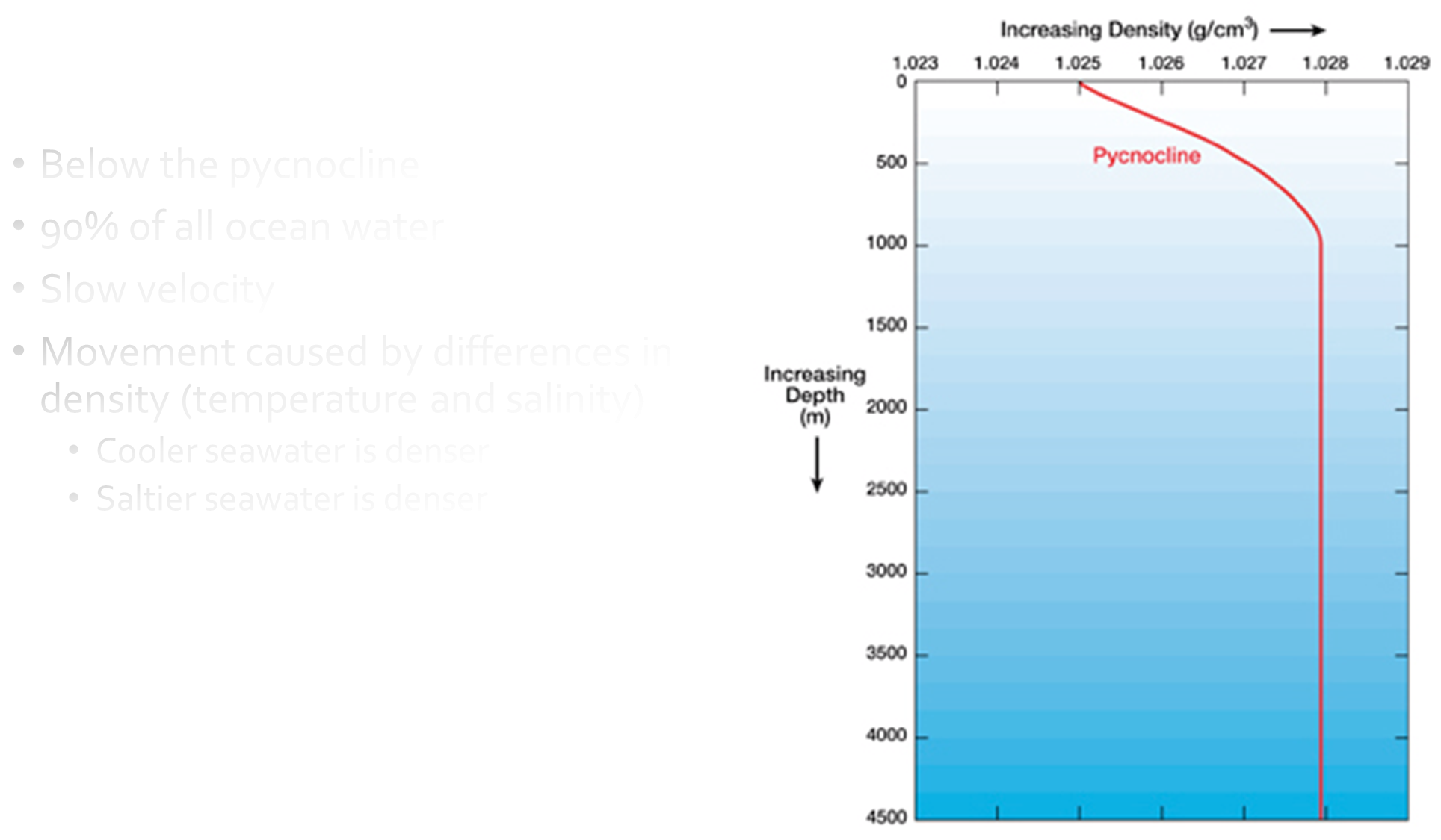
Below the pycnocline
90% of all ocean water•Slow velocity
Movement caused by differences in density (temperature and salinity)
-Cooler seawater is denser
-Saltier seawater is denser
Pycnocline: layer, zone, or gradient corresponding to a rapid change in density with depth.
Thermohaline circulation
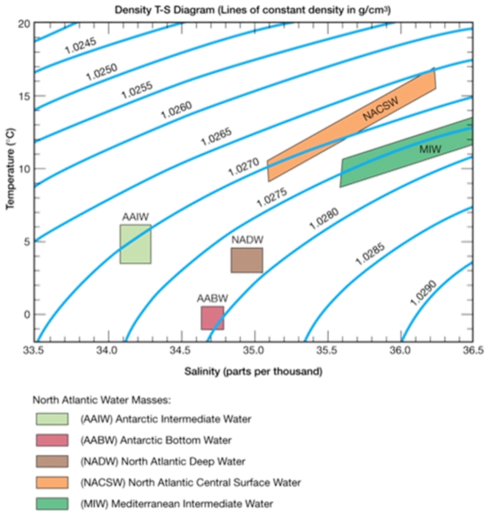
•Originates in high latitude surface ocean
•Once surface water sinks (high density) it changes little
•Deep-water masses identified on T-S diagram
Ocean Circulation
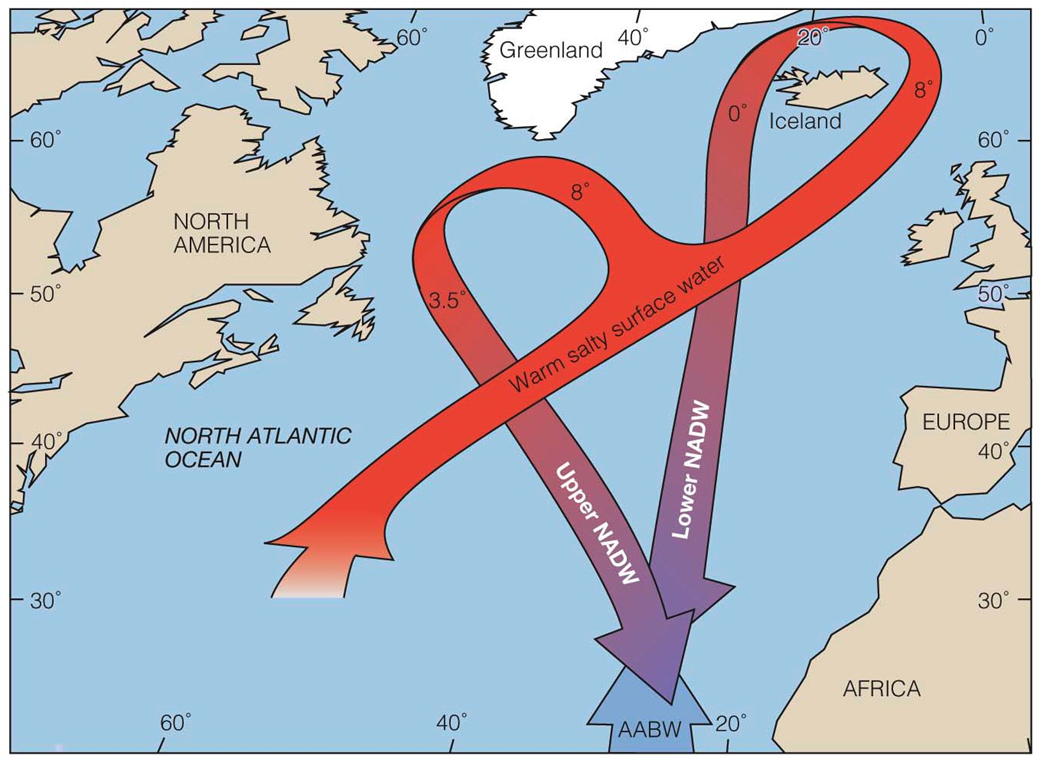
-North Atlantic Deep Water (NADW) originates at the surface of the north Atlantic, flows downward, and spreads southward to the south Atlantic
-Flowing beneath this is the colder, denser Antarctic Bottom Water (AABW)
-The sinking of dense, cold, saline surface water propels a global thermohaline circulation system
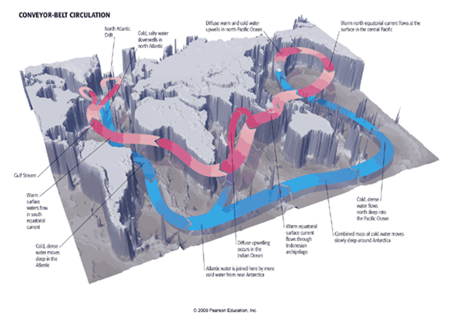
Conveyer Belt Circulation
Deep-water masses in Atlantic Ocean
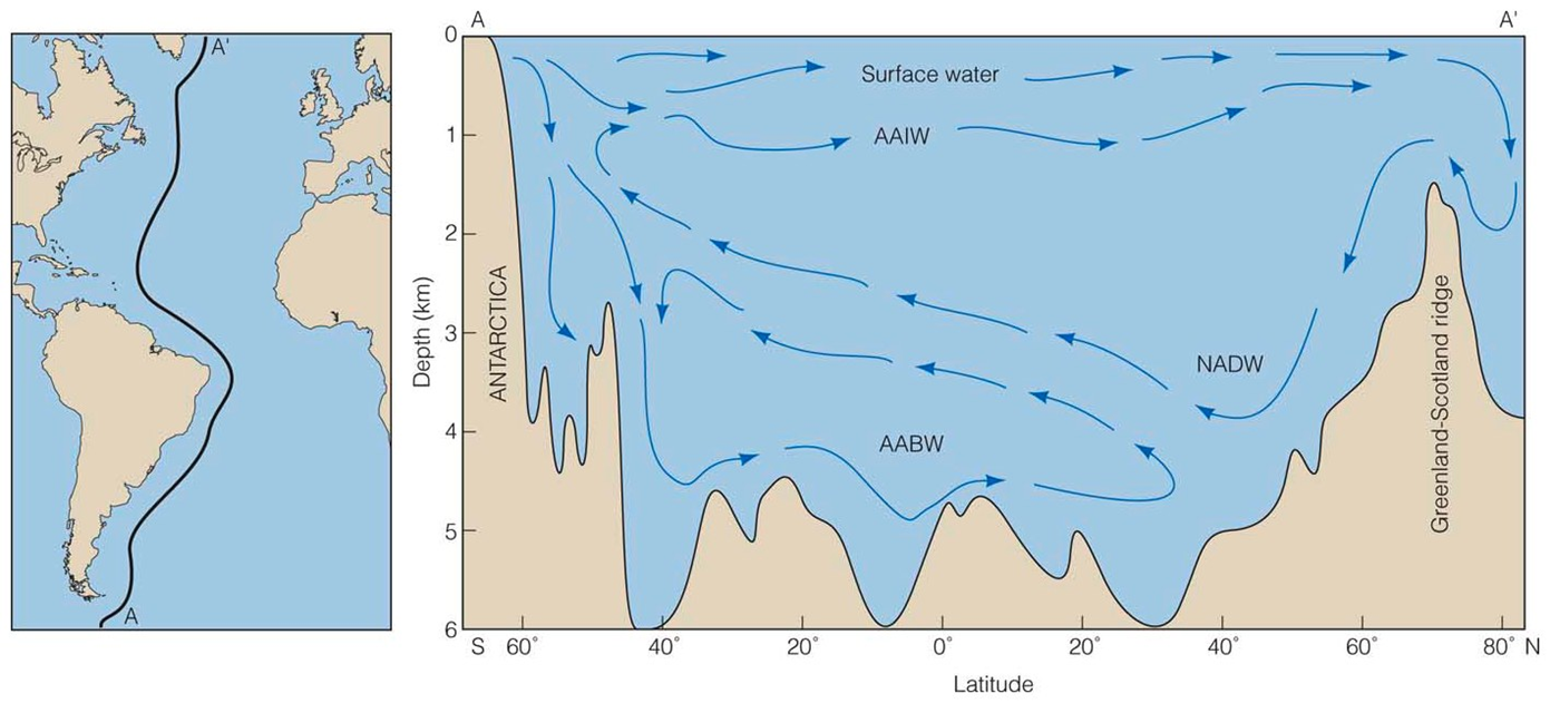
Deep-water masses in Atlantic Ocean
-Antarctic Bottom Water – cold mass that sinks in the vicinity of Antarctica and moves northward
-North Atlantic Deep Water – mass of water that originates in the N. Atlantic and migrates to Antarctica
Thermohaline circulation
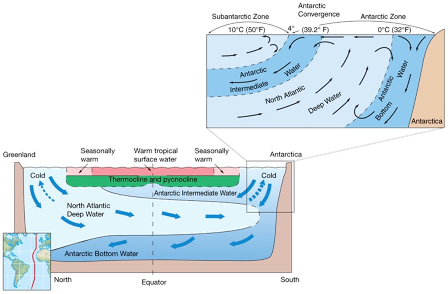
Thermocline – transition layer between mixed layer (similar temp as surface) and deep water layer.
Pycnocline – layer of rapidly changing density
Deep ocean currents
Cold, oxygen-rich surface water to deep ocean
Dissolved O2 important for life and mineral processes
Changes in thermohaline circulation can cause global climate change
-Example, warmer surface waters less dense, not sink, less oxygen deep ocean
Ocean currents and climate
Warm ocean currents warm air at coast
-Warm, humid air
-Humid climate on adjoining landmass
Cool ocean currents cool air at coast
-Cool, dry air
-Dry climate on adjoining landmass
Open ocean’s climate regions are parallel to latitude lines
These regions may be modified by surface ocean currents.
Ocean’s Climate Zones
Equatorial – warm, lots of rain
Rising air, Weak winds
Doldrums
Tropical – warm, less rain
North and south of equatorial zone
Extend to Tropics of Cancer and Capricorn
Strong winds, little precipitation, rough seas
Subtropical – rather warm
High pressure, descending air
Weak winds, sluggish currents
Open ocean’s climate regions exhibit patterns parallel to latitude
Ocean’s Climate Zones 2
Temperate – moderate temperatures
Strong westerly winds
Severe storms common
Subpolar – cold, lots of snow
Extensive precipitation
Summer sea ice
Polar – cold
High pressure
Sea ice most of the year
Open ocean’s climate regions exhibit patterns parallel to latitude
Ocean’s Climate Patterns (Photo)
Ocean currents and climate
The N. hemisphere summer configuration (below) shows the Gulf Stream (narrow, deep and swift) bringing warm water northward
– little upwelling
The return flow is wide, shallow and slow with upwelling
Ocean currents and climate 2
The N. Hemisphere winter configuration (below) shows the temperate ocean off the west coast of Europe and North America.
The return flow is narrower with increased upwelling