TECTONICS
1/39
Earn XP
Description and Tags
geog year 1
Name | Mastery | Learn | Test | Matching | Spaced | Call with Kai |
|---|
No analytics yet
Send a link to your students to track their progress
40 Terms
Two oceanic plates ( or an oceanic and continental) move towards each other, one slides beneath the other into the mantle where it melts in an area called the subduction zone.
When lava cools and becomes rock, minerals inside the rock line up with the Earth’s magnetic direction (polarity) at the time.
Arrangement of these minerals can be analysed to determine the Earth’s past magnetic fields.
Consists mainly of liquid iron and nickel.
Temps range 4500-6000
Structure of the Earth:The mantle
Surrounds the core, and is the widest layer making up the Earth. Upper part is mainly solid, but below the rock is semi-molten (forming the asthenosphere)
Structure of the Earth:The crust
Forms the outer shell of the Earth. There are two types of crust:
Oceanic- A thin, dense layer (6-10 km thick), which lines ocean floors.
Continental-An older, thicker layer(45-50 km thick) which makes up the Earth’s landmasses.
DIVERGENT-2 plates move apart(constructive)
CONSERVATIVE-2 plates slide past each other (transform)
Deep ocean trenches mark place of subduction
Subduction leads to formation of fold mountains
Friction between colliding plates causes intermediate and deep earthquakes in the Benioff zone. Volcanic eruptions are also generated (explosive).
Subducted plate forms magma, which rises up from the Benioff zone to form underwater volcanoes.
Eventually, these volcanoes grow/rise above sea level, to form island volcanoes (usually found in curved lines called island arcs).
\
2004 pacific ocean tsunami
They collide and sediment between them is crumpled to form fold mountains, like the Himalayas.
Mid ocean ridges:
\--Mid ocean ridges of underwater mountains extend for over 60,000 km across the world’s ocean floors. Regular breaks (transform faults) cut across these ridges as they spread at different rates. Shallow focus earthquakes and regular volcanic eruptions ( sometimes creating submarine volcanoes) occur.
Rift valleys:
\-When plates move apart on continents, the crust stretches and breaks into sets of parallel cracks (faults). The land between these faults then collapses, forming steep sided valleys called rift valleys.
Conservative plate margins
There is major breakage in the crust between the plates as they move. The break itself is called a fault ( on a large scale: transform fault). No crust is made or destroyed (no volcanic activity), but this type of plate is very tectonically active-- powerful earthquakes.
The two plates sometimes stick together as they move, causing stress and pressure to build up, which is suddenly released as a shallow-focus earthquake.
Primary waves (P waves) ‘push’ through the Crust, mantle and core. - body waves
Secondary waves(S waves) ‘shake’ through the crust and mantle only.- body waves
Love waves (L waves) move side to side (surface waves)
MAGNITUDE(amnt of energy released at epicentre)
Moment magnitude scale= measures the total energy released by earthquake at the moment it occurs using the: size of seismic waves, amount of slippage/rock movement, area of fault surface broken, resistance of affected rocks.
Modified Mercalli Intensity Scale=takes observations from people who experienced the earthquake to rate on a scale of I (hardly noticed) to X (catastrophic).
Crustal fracturing-When energy released during an earthquake causes the earth’s crust to crack.
Landslides and avalanches- Ground shaking puts stress on slopes, so they fail.
Tsunami-underwater earthquakes generate tsunami.
Pyroclastic flows- Mixture of dense hot rock, lava, ash and gases ejected from a volcano which move very quickly across the Earth’s surface. Fast and destructive (up to 700 degrees, 100km/h).
Tephra and ash falls-Tephra are pieces of volcanic rock and ash that blast into the air during a volcanic eruption. Larger pieces tend to fall near the volcano and smaller pieces such as ash can travel for thousands of km. Ash falls are very disruptive (poor visibility, slippery roads).
Gas eruptions-Magma contains dissolved gases that are released into the atmosphere during a volcanic eruption (potential hazard, can travel thousands of km)
Jokulhaup- The heat of volcanic eruption can melt snow and ice in a glacier, causing heavy and sudden floods (dangerous).
Volcanic Explosivity index (VEI)
Describes and compares the size+ magnitude of volcanic eruptions.
Scale of 0 (non-explosive) to 8 (extremely large).
Several factors used: Amount and height of volcanic material,length of eruption, qualitative descriptive terms (gentle, explosive etc)
EFFECTS:
\-Dozens dead, 7000 moved (over half of original 11,000).
\-Capital, Plymouth, destroyed.
\-2/3 housing and 3/4 infrastructure destroyed.
\-Lots of farmland destroyed or abandoned.
\-Top heavy population pyramid: young people no longer saw a future on the island.
Volcano Case Study 2:Eyjafallajokull
2010, flights over large parts of Europe were cancelled for a week, as a spreading ash cloud from the eruption of Eyjafallajokull in Iceland threatened to clog aircraft engines and stop them from working.
-100,000 commercial flights cancelled worldwide.
-European economy lost US$5 billion
\-small earthquakes:as the magma rises to the surface, it breaks rocks, causing small earthquakes that scientists can often detect using seismograms.
\-Changes to the surface of the volcano: as it pushes upwards, magma builds pressure (causing the surface of the volcano to swell).
\-Changes to the ‘tilt’ of the volcano: as the magma moves inside the volcano, it changes the slope angle or ‘tilt’ of the volcano.
Predicting Tsunami
Due to the causation of tsunami mainly being earthquakes (difficult to predict), there is no way to predict Tsunami before they occur.
Instead, Tsunami early warning systems are now in place in both the Pacific and Indian Oceans. These systems use seismic sensors to detect undersea earthquakes.
In 2004, the Indian Ocean did not have such systems, allowing for more deaths in Sri Lanka where people would have otherwise had plenty of time to evacuate. Japan has the most extensive earthquake and tsunami warning systems in the world. When 9.0 magnitude earthquake struck in 2011, warning were issued. However, the system (in part) failed because the size of the earthquake was underestimated, causing people to choose not to evacuate or prepare.
Governance and natural disasters Case study 2:Japan 2011
-Good building construction (strict building regulations =75% of buildings are built with earthquakes in mind).
-Low level of corruption
-Well-developed disaster plans.
-Education and preparedness for earthquakes and tsunami- emergency drills practised regularly in both schools and businesses.
(despite this investment in disaster planning, Japan failed to take into account the impact of a tsunami on a nuclear power plant--contributing to the events at Fukushima)
RESPONSE:
-within 24 hours, 110,000 defense troops mobilised
-Immediately after the earthquake, all radio and TV stations switched to official earthquake coverage, advising people.
-The Bank of Japan offered US$183billion to Japanese banks to keep them operating (protecting the economy).
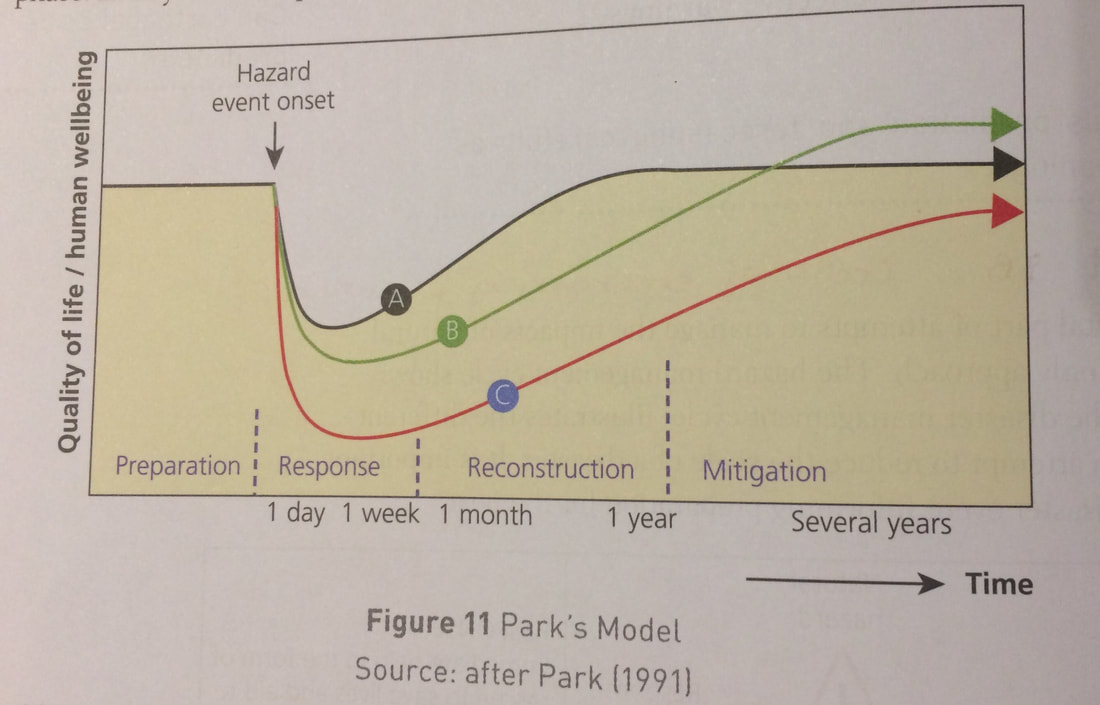
The hazard management cycle
The Hazard management cycle is a tool to help us understand the response, recovery, mitigation and preparedness for natural hazards.
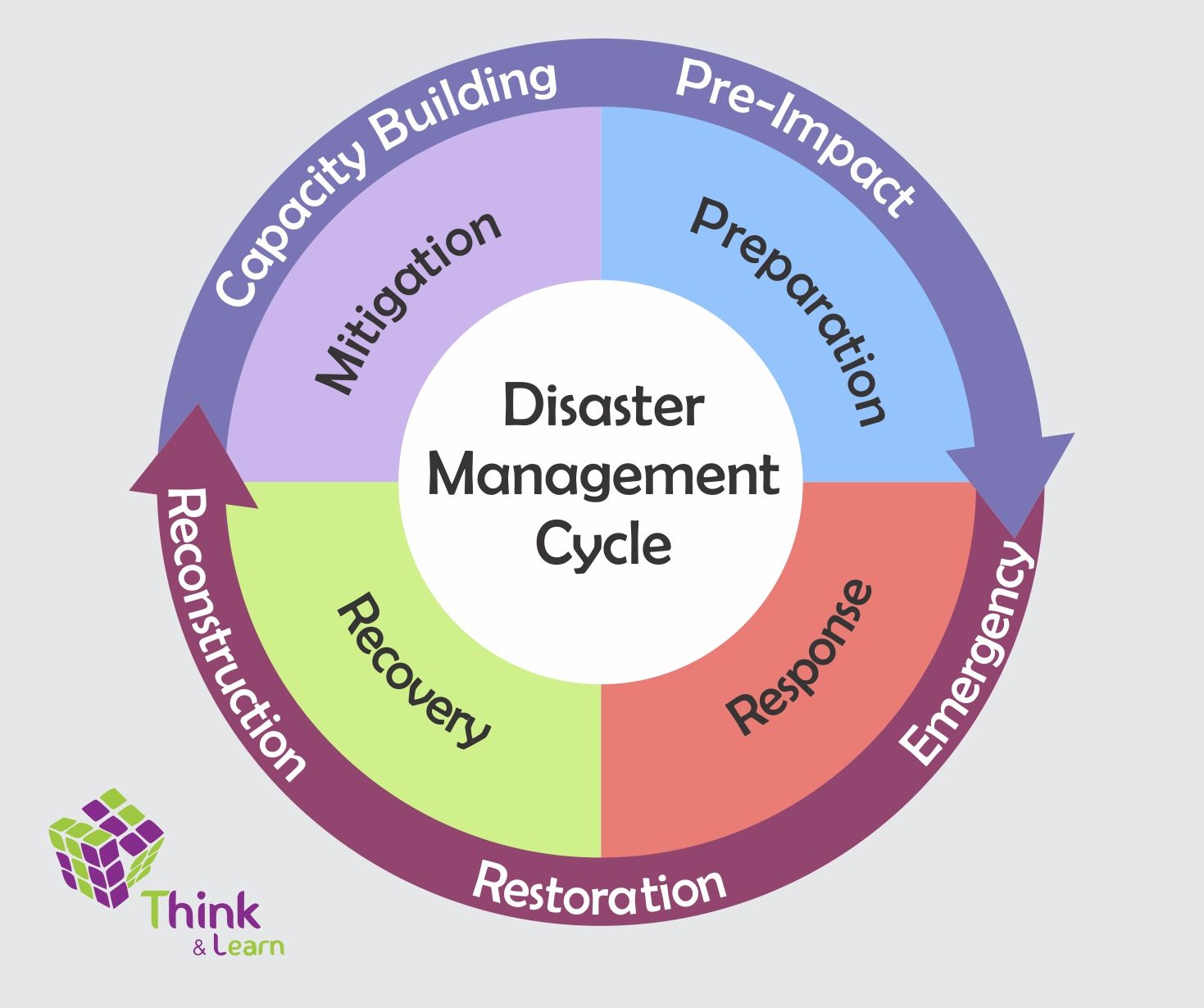
\-The impacts of a hazard event change over time- depending on factors such as the size of the hazard, the development level of the areas affected and the aid received.
\-All hazard events have different impacts, so their curves are different. For example, hazard events that happen suddenly (such as the 2010 Haiti earthquake), and those that happen more slowly (Montserrat 1995+ a few years)have different responses.
\-Wealthier countries have different curves than developing countries, because they will be able to recover much faster.
\
Hazard adaptation?
Hazard adaptation=Strategies designed to reduce the impacts of hazard events
2)Diverting Lava flows (with consideration of which areas are more profitable or important)
3)Hazard resistant design and engineering defenses.
2)Crisis mapping(using crows sourced info and other methods such as satellite mapping, areas struck by disasters can be accurately mapped for recovery efforts).
3)Public education
Capacity to cope(C)
HAITI
Jan 2010 7.0 earthquake struck near capital.
Shallow focus (13km)which increased ground shaking, Liquefaction on looser soil caused building foundations to sink, epicentre was only 24 km from Port-Au-Prince (country’s capital and most populated city).
Haiti is a developing country-poor,and limited resources are spent on more immediate issues such as disease instead of earthquake prevention.
Lack of building controls and regulations+ disaster preparation.
Over a quarter of government officials killed, poor infrastructure (1 airport, several ports and a few main roads). Oct 2010, outbreak of cholera.
* Concerns about mismanagement and corruption meant that many organisations were unwilling to channel money through the Haitian government- hampering Haiti’s ability to become self-sufficient.
* Some improvements: 2012 (hurricane Sandy)government warned citizens and told them to get to higher ground, saving lives+ after the storm the government took a leading role in organising international aid.