Biogeography Exam 2
1/74
There's no tags or description
Looks like no tags are added yet.
Name | Mastery | Learn | Test | Matching | Spaced |
|---|
No study sessions yet.
75 Terms
Small populations
founder effects, drift, inbreeding
founder effect
colonists carry subset of mainland diversity
Inbreeding
Lower fitness (inbreeding depression)
ecological release
niche expansion, high densities
generalists win over specialists
broader diets and habitat flexibility
small islands
fewer coexisting niche competitors
over generations we see…
less dispersal capacity favored
evolution works faster on…
islands rather than the mainland
plant diaspores
achene increase, pappus decrease
time scale
few generations on small islets
tendency (the island rule)
small vertebrates —> larger; large —> dwarfs
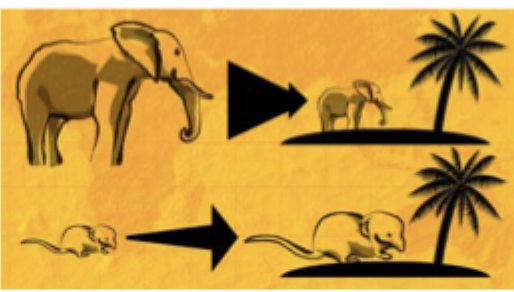
drivers (the island rule)
resource limits, enemy release, stability
examples (the island rule)
komodo (giant varanids); pygmy elephants
caveat (the island rule)
mixed empirical support across taxa
hotspot chain (Hawaii)
age gradient NW(old) —> SE (young)
each island (hawaii)
stages: emergence —> growth —> erosion
high relief (Hawaii)
“islands within islands” mountain isolates
result (Hawaii)
extreme endemism & repeated isolations
plants (Hawaii)
mostly bird-borne (zoochory), wind, sea minority
insects (hawaii)
overwhelmingly airborne to reach the island
vertebrates (hawaii)
bats (native), many groups absent initially
humans later added what to Hawaii?…
Ants. and other invaders —> reshaped the biota of the island
wind-dispersed dispersal
tiny seeds ride air currents
Zoochory dispersal
animals eat seeds and poop it somewhere else
Phoresy (dispersal)
small animals (ectoparasites) move through other animals
By sea dispersal
buoyant seeds float on currents to new shorelines
Rafting dispersal
whole organisms raft on something after a storm/flood to new place
passive airborne dispersal
animals picked up and carried by wind
active airborne
animals fly themselves to islands
sequential islands
stepwise isolation and opportunities
topographic diversity
microhabitats and climate zones
strong selection + small Ne = …
fast divergence
ETIB = Equilibrium Theory of Island Biogeography
that the number of species on an island is a dynamic balance between immigration and extinction. This equilibrium is determined by two key factors: the island's size (larger islands have lower extinction rates) and its distance from the mainland (closer islands have higher immigration rates).
Immigration Curve (I) (ETIB)
fast at first, steep drop as “easy” colonists arrive, isolation matters. bigger islands present a bigger target
Extinction Curve (E)
rises with species, area matters (larger islands = larger N). Immigration to near islands lowers effective E
Species-Area Relationship (SAR)
habitat diversity increases, pop size increases, sampling increases
Habitat “Islands” Predictions
larger/less isolated fragments sustain higher S
single large —> SLOSS (Single Large Or Several Small)
lower E, more interior habitat, supports area-demanding taxa
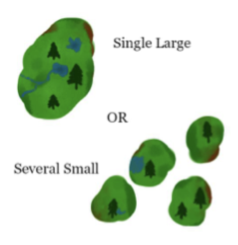
several small —> SLOSS (Single Large Or Several Small)
capture beta-diversity, insure against local catastrophes

SLOSS answer…
context-specific —> consider heterogeneity, covariance of risks, target taxa

ETIB to GEIB (Generalized/Integrative)
blend area, isolation, heterogeneity, traits, interactions, evolution
land
clear regions, strong barriers (ocean, mountains, deserts, etc.)
sea
high-density medium, fully pelagic lifestyles common
pelagic (water column)
dynamic, circulation-driven
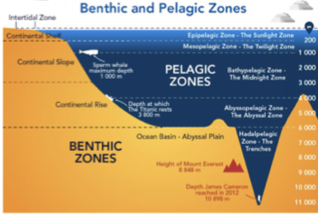
benthic (seafloor)
substrate/depth-driven, higher local endemism

continental shelf (ocean architecture)
(to ~200m) —> shelf break —> slope —> rise
abyssal plain (ocean architecture)
(3,500-6,000m) most extensive environment
trenches (ocean architecture)
(~11,000m) hadal
euphotic zone (zonation)
photosynthesis possible, upper few tens of m
epipelagic zone (zonation)
wind-mixed; ~tens of m to ~200m
Pycnocline zone (zonation)
most important boundary
what is the most important/distinguishing factor in the ocean?
the pressure, light, and temperature
upwelling
tiny area, huge fishery yield
great ocean basins
major biogeographic units
ocean basins
primary biogeographic backdrop
case hook
mid-latitude peak in planktonic foraminifera tied to pycnocline structure
Longhurst biomes…
polar, westerly winds, and trade winds biomes (33 different provinces in the biomes)
spalding realms…
coherent higher-taxon histories; high endemism
spalding biomes
group provinces with shared ocean processes biomes
spalding provinces
large epipelagic areas with stable/recurrent drivers
Range Extension (Diffusion)
Devonian “Greening”
vascular plants/first trees expand, because of this there is a long-term cooling and “ice-house” tendencies set up
Carboniferous Coal Forests
350-300million yrs ago, ever-wet equatorial rainforests: massive peat/coal formation
Permian Worldbuilding
300-250million yrs ago, regional floras (Angaran, cathaysian, euramerican, gondwanan) Late Permian collisions → Pangaea
Jurassic-Early Cretaceous Flora Belts
200-150million yrs, equatorial summer-wet tropics, subtropical deserts, winter-wet belts, warm/cool temperate zone.
High-latitude Warmth
Late Jurassic to Early Cretaceous (~160-110 Ma)
Angiosperms & Foraging Heights
Early cretaceous (~125-100mil yrs) High browse (palms/conifers/angiosperms)
Asteroid Impact
K/Pg, Yucatán the asteroid impact killed all the dinosaurs 66 million yrs ago. Lots of ejecta, soot, and sunlight reduction/ozone loss/acid rain.
“Age of the mammals”
65mya to present, mammals diversified greatly. Professor thinks this is biased naming cause we are mammals, lots of animals diversified at this time
PETM
rapid carbon release, strong global warming (56 mya) ocean acidification, biogeographic turnover
regionalization
the process of dividing the world into areas that share distinctive species and evolutionary histories
regionalization inputs
species composition & range data; endemism and turnover patterns; environmental and barrier context
Quantifying Regions Inputs (clustering)
species range maps by grid cell
Quantifying regions outputs (clustering)
regions + subregions that are testable and comparable