APES Ocean in Action Exam
1/70
There's no tags or description
Looks like no tags are added yet.
Name | Mastery | Learn | Test | Matching | Spaced | Call with Kai |
|---|
No analytics yet
Send a link to your students to track their progress
71 Terms
What are the freshwater biomes?
Streams, rivers, ponds, lakes.
Where does drinking water come from?
Freshwater biomes.
What are marine biomes?
Intertidal, coral reefs, open ocean, swamps (wooded) marshes (non-wooded), estuaries.
What supplies the largest portion of the earth's oxygen and in take of CO2 from the atmosphere?
Algae in marine biomes.
What biomes have the highest primary productivity & biodiversity?
Coral reefs & estuaries.
True or false: Nitrogen and phosphorus nutrient amounts are greater along the coastlines as a result of runoff into rivers & eventually estuaries.
True.
What are the different categories of wetlands?
Marshes (non-woody), swamps (wooded), bogs (acidic, peat or sphagnum moss)
Abiotic conditions in aquatic vs terrestrial:
Aquatic: Depth, Light, Temperature, Velocity (currents), Salinity , Oxygen, Nutrients: Nitrates & Phosphates, Suspended Matter (Silt), Bottom substrate (muddy, sandy, rocky)
Terrestrial: Annual average precipitation, annual average temperature, latitude & altitude, soil type, topography, wind speed.
What biome is best characterized as an area that forms the narrow band along the coast that experiences a range of environmental conditions (including daily changes in sunlight, temperature, and water)?
The intertidal zone is found along coastlines (from rocky cliffs to sandy beaches) that experience different levels of high and low tide. Organisms that inhabit these areas must be adapted to withstand changes in direct sunlight, temperature, and desiccation as well as the crashing waves.
What factors can decrease the amount of freshwater flowing in the Everglades ecosystem?
Irrigation for crops, domestic uses, industrial processes, diverted for flood control, road construction/development, Everglades being filled in for agriculture & housing developments.
What human activities increase phosphorus levels in the Everglades?
Runoff from agriculture, lawns, & golf courses, Animal waste, Septic systems, Discharge from wastewater systems, Use of phosphate containing detergents.
What is habitat fragmentation?
When 1 piece of land splits into 2. Species will adapt to each environment & the best one wins.
Where will the HIGHEST species richness be found?
On LARGE islands NEAR the mainland.
Where will the LOWEST species richness be found?
On SMALL islands FAR away from the mainland.
What is a population pyramid?
Also known as an age structure diagram, meant to show the distribution of ages of a certain pop, divided into males & females. Not always a pyramid.
What are the different parts of a pop pyramid?
X-axis: # of individuals (thousands, millions, or %)
Y-axis: Tends to be the center of diagrams, shows age groups.
Age groups are subdivided by reproductive ability
What are the 3 sections of an age structure diagram?
Pre-reproductive (0-14), reproductive (15-45), post-reproductive (46-100+).
What does it mean if the age structure diagram is bottom heavy?
Pop. is growing quickly, usually reproducing longer, indicator of a developing nation.
Ex: India, Brazil, Nigeria, Mexico.
What does it mean if the age structure diagram is middle heavy/rectangular?
Pop. growth is steady, developed & well off.
Ex: U.S, Australia, Canada, Sweden.
What does it mean if the age structure diagram is top heavy?
Pop. may be negative/declining, economically & socially developed, higher education is common, long term social services may be impacted.
Ex: Japan, Italy, Russia, Germany.
What does stage 1 look like in age structure diagrams?
Pre-industrial: Children are needed in the workforce, younger nations/pops usually have higher infant mortality rates.
What does stage 2 look like in age structure diagrams?
Transitional: Improved medicine, sanitization & food, very high growth rate.
What does stage 3 look like in age structure diagrams?
Industrial: High education, low infant mortality, slow growth.
What does stage 4 look like in age structure diagrams?
Post-industrial: High education, low infant mortality, older pops = tax burden, 0 or negative growth.
How do you calculate doubling time?
70/r. R= growth rate. Use a % !
If a pop is 8.4 million in 2018 & an r of 2.27, whats the pop going to be in 2050?
Options: 10.7 mill, 17.2 mill, 19.1 mill, & 30.8 yrs.
Step 1: Doubling time: 70/2.27 = 30.8 yrs.
Step 2: 2050-2018 = 32 yrs, allows the pop to double 1X.
Step 3: Double 8.4 one time = 16.8 mill, closest is 17.2 mill.
What is the total fertility rate?
The average # of children a woman will have throughout her childbearing years, always a decimal!
What is the TFR for developing nations?
2.1+
What is the TFR for developed nations?
Below 2.1
What factors impact the TFR?
Age of first pregnancy, educational opportunities, family planning, governmental policies, infant mortality rates related to healthcare access.
What factors impact human pops?
Birth rates, death rates, education, infant mortality, age of marriage, nutrition.
How do human pops. experience carrying capacity?
They're limited by density overshoot and density independent & dependent factors.
What are the density independent factors?
Storms, fires, heat waves, droughts.
What are the density dependent factors?
Food availability, territory size, disease transmission, access to clean air & water.
What is replacement-level fertility?
The number of children a couple must produce to "replace" themselves.
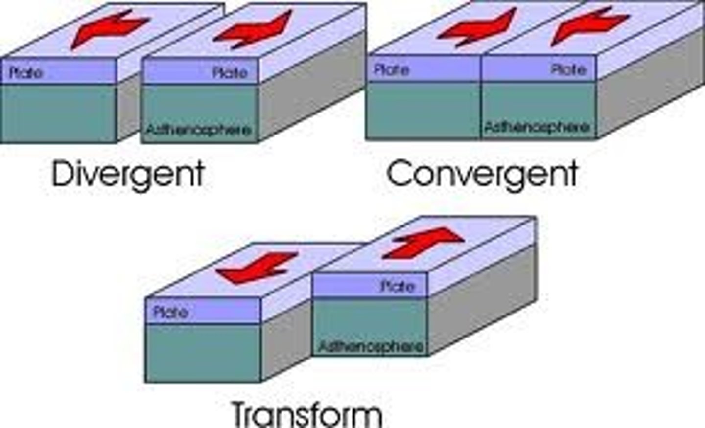
What are the characteristics of convergent plate boundaries?
Plates pushed together, typically involves volcanoes, releases magma, may cause earthquakes.

What are the characteristics of divergent plate boundaries?
Pushes away, typically causes sea floor spreading & less frequent earthquakes, may have ridges or volcanoes.

What are the characteristics of transform or strike/slip plate boundaries?
Plates slide past each other, no ridges or volcanoes, tends to have shallow frequent earthquakes.
What is the subduction zone?
Where 2 plates meet & 1 goes under the other.
How do earthquakes occur?
Stress at fault lines builds up until it releases.
What are the environmental consequences of tsunamis?
Destroys habitat, drowns species, uproots trees, containminates water w/ debris & salt water.
What is the Coriolis Effect?
The effect of Earth's rotation on the direction of winds and currents. Along w/heat, rotation of the Earth deflects the wind as well. Helps predict wind patterns
What factors are winds driven by?
Solar radiation & the Coriolis Effect ☀️
How do you determine the isolation?
Solar radiation/area
What does it mean if a surface has HIGHER insolation?
Surface most perpendicular to the sun.
What does it mean if a surface has LOWER insolation?
Not perpendicular to the sun, closer to the poles.
What is the angle of incidence?
The angle that is formed by a ray of sunlight colliding with a line perpendicular to a surface.
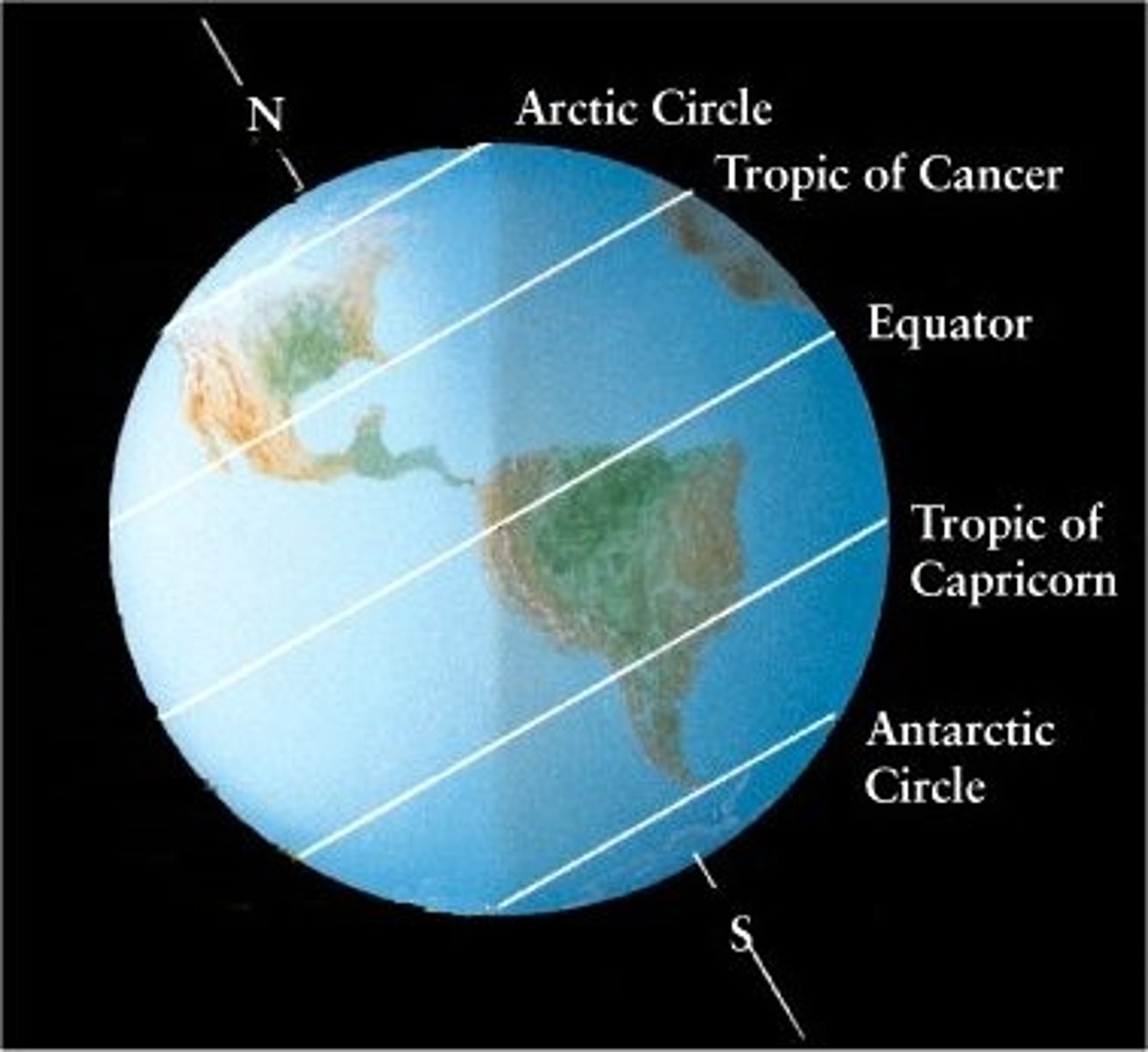
What biomes will be found on each line of the Earth?
- Rain forests are found closer to the equator, where a lot of precipitation falls. These conditions require moist air, which is not found at the indicated latitudes where dry air descends from the upper atmosphere.
- Deserts form where dry air descends from the upper atmosphere, heating up as it does so. 30° N & 30° S
- Coniferous forests are located in cooler climates, closer to 60° north and south.
- Tundras are located in cooler climates, closer to 70° north and south.
Seasons in the Northern Hemisphere
Shortest day/polar night: Dec 21-22
Days & Nights are equal: Sept. 22-23
Longest Day & Midnight Sun: Jun. 20-22
Days & Nights are equal: Mar. 20-21.
Seasons in the Southern Hemisphere
Equinox days are the same.
Longest day/Midnight Sun: Dec. 20 or 21
Shortest Day/Polar Night: Jun. 20 or 21
What do large bodies of water do for local temperatures?
Stabilize them.
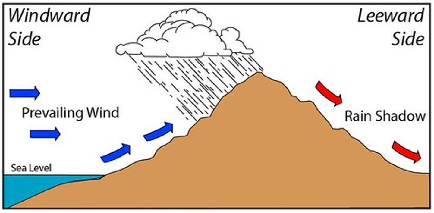
What is the rain shadow effect?
Occurs when:
#1 Moisture from the ocean gets picked up
#2 Gets shunted upwards a mountain & cools + turns into clouds
#3 hot, dry air expands & takes up moisture on the leeward side
#4 creates arid or desert area.
What do normal wind conditions look like?
Winds blow East (South America) to West (Australia)
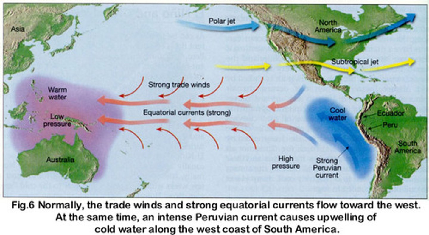
What do El Nino wind conditions look like?
Winds blow West (Australia) to East (South America). Winds stall, may reverse to become Westerlies, note change of location of clouds.

What are the impacts of El Nino?
Drier conditions in Australia-enhanced risk of fire & drought. Warmer & wetter conditions in S. America - enhanced risk of floods and landslides. Warmer & wetter winter in Canada and N. US.
What are the impacts of La Nina?
Wetter conditions in Australia & Indonesia - enhanced risk of floods & landslides. Cooler & drier conditions in S. America. Colder winter in Canada & Northern US.
What do La Nina wind conditions look like?
Same conditions as neutral/normal currents, just more intense. The movement of the warm current is closer to the Australian shoreline. Enhanced upwelling.

What is aquaculture?
Farming of fish, shellfish, mollusks, crustaceans, or aquatic plants by an individual or corporation w/the intent to sell.
Who's the worldwide leader for aquaculture?
China.
What are the advantages of aquaculture?
Provides high-quality protein to a growing human pop, provides stable income w/ less risk than open-water fishing, less acreage, water, & fossil fuels are used compared to terrestrial agriculture.
What are the disadvantages of aquaculture?
Nitrogenous waste can pollute waterways (leading to eutrophication), uneaten feed can pollute waterways (leading to water-quality issues), escaped farm organisms can interbreed or compete with wild organisms, diseases & parasites from densley packed farmed populations can spread to wild pops, medications to control disease in farmed organisms can pollute waterways.
What is eutrophication?
A body of water that is enriched w/excess nutrients & the evidence is usually seen by high pops of algae & plant blooms. Nitrogen from agricultural or urban runoff & phosphate in detergents.
What are wetlands?
Areas that have soil covered or near the surface for all/most of the year.
What are coastal (tidal) areas?
Wetlands that have fluctuating salinity & water levels as they are influenced by the tides.
What are inland (non-tidal) areas?
Wetlands that are along rivers & flood plains, in depressions or low-lying areas near lakes & ponds, often have a seasonal nature to them.
What happens to sediments, nutrients, & pollutants in wetlands?
They decrease b/c the water moves out of wetlands b/c of its filtering capacity.
How do wetlands prevent/control flooding and protect & stabilize coastal shorelines?
By holding & releasing water slowly.
Why are mangroves a better decision, environmentally, than forests?
They can absorb 4X more CO2 than trees
What are ways that humans hurt wetlands?
- Commercial development can damage wetlands by destroying habitat, altering water flow, & increasing sedimentation.
- Dam construction disconnects wetlands from their water sources & prevents migration of species & the natural flow of sediments for delta formation.
- Agricultural & industrial activities can contribute to excess nutrients & pollutants to wet lands.
- Overfishing can shift the ages & types of fish remaining, causing an imbalance in the wetland food web.
What is oligothophic?
A body of water w/very low nutrient levels stable algae pops as well as high dissolved oxygen levels.
How are wetlands regulated?
Through the Wetlands Protection & Restoration Act :)