Chapter 2: Glaciated landscapes - OCR A-Level Geography
1/135
There's no tags or description
Looks like no tags are added yet.
Name | Mastery | Learn | Test | Matching | Spaced | Call with Kai |
|---|
No analytics yet
Send a link to your students to track their progress
136 Terms
2.1 How can glaciated landscapes be viewed as systems?
Key idea ⮕ Glaciated landscapes can be viewed as systems.
The components of open systems
-Inputs
-Outputs
-Throughputs
Inputs (The components of open systems)
Including kinetic energy from wind and moving glaciers, thermal energy from the heat of the Sun and potential energy from the position of material on slopes; material from deposition, weathering and mass movement from slopes and ice from accumulated snowfall.
Outputs (The components of open systems)
Including glacial and wind erosion from rock surfaces; evaporation, sublimation and meltwater.
Throughputs (The components of open systems)
Which consist of stores, including ice, water and debris accumulations; and flows (transfers), including the movement of ice, water and debris downslope under gravity.
Open system theory vs Glacial system
Page 39.
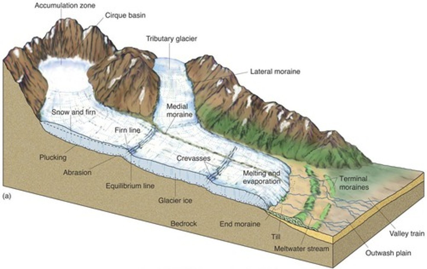
Glacier mass balance (Diagram)
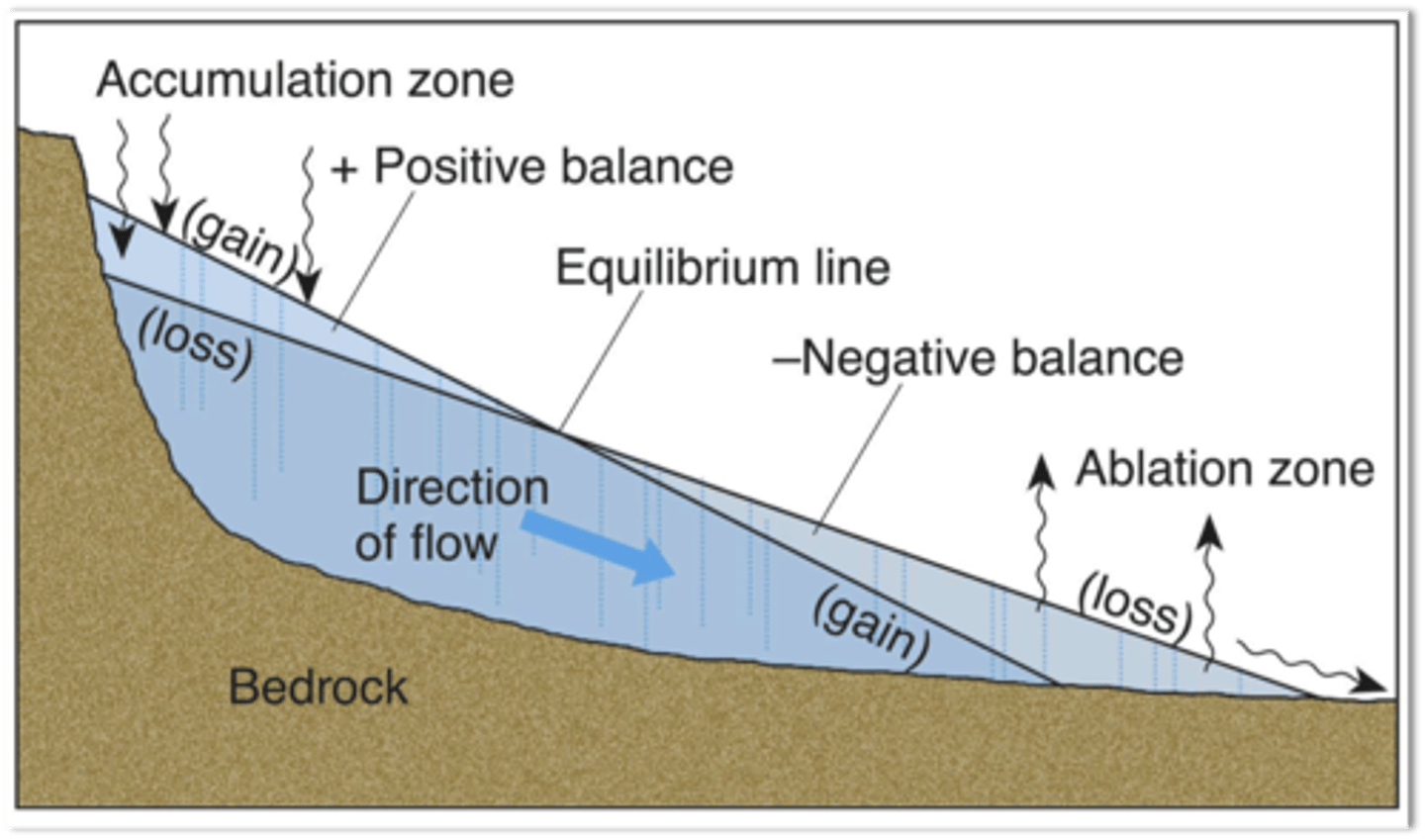
Glacier mass balance
The glacier mass balance, or budget, is the difference between the amount of snow and ice accumulation and the amount of ablation occurring in a glacier over a one year time period.
The majority of inputs occur towards the upper reaches of the glacier and this area, where accumulation exceeds ablation, is called the accumulation zone.
Most of the outputs occur at lower levels where ablation exceeds accumulation, in the ablation zone. The two zones are notionally divided by the equilibrium line where there is a balance between accumulation and ablation.
Ablation / Ablation zone
Refers to the low-altitude area of a glacier or ice sheet with a net loss in ice mass due to melting, sublimation, evaporation, ice calving, aeolian processes like blowing snow, avalanche, and any other ablation.
Accumulation / Accumulation zone
Occurs through accumulation of snow and other frozen precipitation, as well as through other means including rime ice, avalanching from hanging glaciers on cliffs and mountainsides above, and re-freezing of glacier meltwater as superimposed ice.
Sublimation
The transition of a substance directly from the solid to the gas state, without passing through the liquid state.
Climate and glaciers
Wind is a moving force and as such is able to carry out erosion, transportation and deposition. These aeolian processes contribute to the shaping of glaciated landscapes, particularly acting upon fine material previously deposited by ice or meltwater.
Precipitation is a key factor in determining the mass balance of a glacier, as it provides the main input of snow, sleet and rain. (See page 41)
Geology and glaciers
The two key aspects of geology that influence glaciated landscape systems are lithology and structure.
Lithology (Geology and glaciers)
Describes the physical and chemical composition of rocks.
Some rock types, such as clay, have a weak lithology, with little resistance to erosion, weathering and mass movements, as the bonds between the particles that make up the rock are quite weak.
Others, such as basalt, made of dense interlocking crystals, are highly resistant and are more likely to form prominent glacial landforms such as arêtes and pyramidal peaks.
Others, such as limestone, are predominantly composed of calcium carbonate. This is soluble in weak acids and so is vulnerable to decay by the chemical weathering process of carbonation, especially at low temperatures.
Structure (Geology and glaciers)
Concerns the properties of individual rock types such as jointing, bedding and faulting. It also includes the permeability of rocks.
In porous rocks, such as chalk, tiny air spaces (pores) separate the mineral particles. These pores can absorb and store water - a property known as primary permeability. Carboniferous limestone is also permeable, but for a different reason. Water seeps into limestone because of its many joints. This is known as secondary permeability. The joints are easily enlarged by solution.
Structure also includes the angle of dip of rocks and can have a strong influence on valley side profiles. Horizontally bedded strata support steep cliffs with near vertical profiles. Where strata incline, profiles tend to follow the angle of dip of the bedding planes.
Relief, aspect and glaciers
Latitude and altitude are the major controls on climate, however, relief and aspect have an impact on microclimate and the movement of glaciers.
The steeper the relief of the landscape, the greater the resultant force of gravity and the more energy a glacier will have to move downslope. Where air temperature is close to 0ºC, it can have a significant influence on the melting of snow and ice and the behaviour of glacier systems.
The formation of glacier ice
Forms when temperatures are low enough for snow that falls in one year to remain frozen throughout the year. Fresh snow falls on top of the previous year's snow. Fresh snow consists of flakes with an open, feathery structure and a low density of about 0.05 g/cm³ (grams per cubic centimetre).
Each new fall of snow compresses and compacts the layer beneath, causing the air to be expelled and converting low density snow into higher density ice.
Valley glaciers
Valley glaciers are confined by valley sides. They may be outlet glaciers from ice sheets or fed by snow and ice from one or more corrie glaciers. They follow the course of existing river valleys or corridors of lower ground. They are typically between 10 and 30 km in length, although in the Karakoram Mountains of Pakistan they are as long as 60 km.
Ice sheets
Glaciers are large, slow-moving masses of ice. Ice sheets are the largest accumulations of ice, defined as extending for more than 50,000 km². There are currently only two: Antarctica and Greenland.
Today these possess 96% of the world's ice. During the last glacial period (LGP or Pleistocene) huge ice sheets also covered much of Europe. The Antarctic ice sheet covers 13.3 million km² and has a volume of about 30 million km³. At its thickest, in eastern Antarctica, it is over 4,700 m deep.
Warm-based (temperate) glaciers are characterised by
-High altitude locations
-Steep relief
-Basal temperatures at or above pressure melting point
-Rapid rates of movement, typically 20-200 m per year
Cold-based (polar) glaciers are characterised by
-High latitude locations
-Low relief
-Basal temperatures below pressure melting point and so frozen to the bedrock
-Very slow rates of movement, often only a few metres per year
Cold-based glacier vs Warm-based glacier
Page 44.
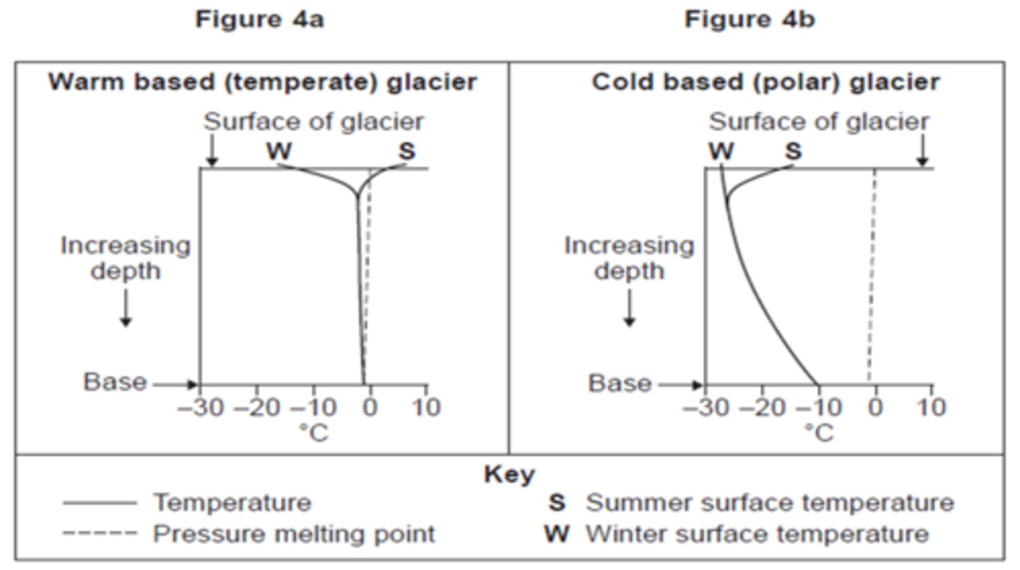
Pressure melting point
The pressure melting point is the temperature at which ice melts at a given pressure.
The pressure melting point is nearly a constant 0 °C at pressures above the triple point at 611.7 Pa (Pascals), where water can exist in only the solid or liquid phases, through atmospheric pressure (100 kPa) until about 10 MPa.
Triple point
The temperature and pressure conditions at which the solid, liquid, and gaseous phases of a substance coexist at equilibrium.
Factors that influence the movement of glaciers
-Gravity - the fundamental causes of the movement of an ice mass
-Gradient - the steeper the gradient of the ground surface, the faster the ice will move if other factors are excluded
-The thickness of the ice - as this influences basal temperature and the pressure melting point
-The internal temperatures of the ice - as this can allow movements of one area of ice relative to another
-The glacial budget - a positive budget (net accumulation) causes the glacier to advance
Two zones in a glacier where different movements occur
-An upper zone where the ice is brittle and breaks
-A lower zone where under pressure the ice deforms
Zones of glacier movement
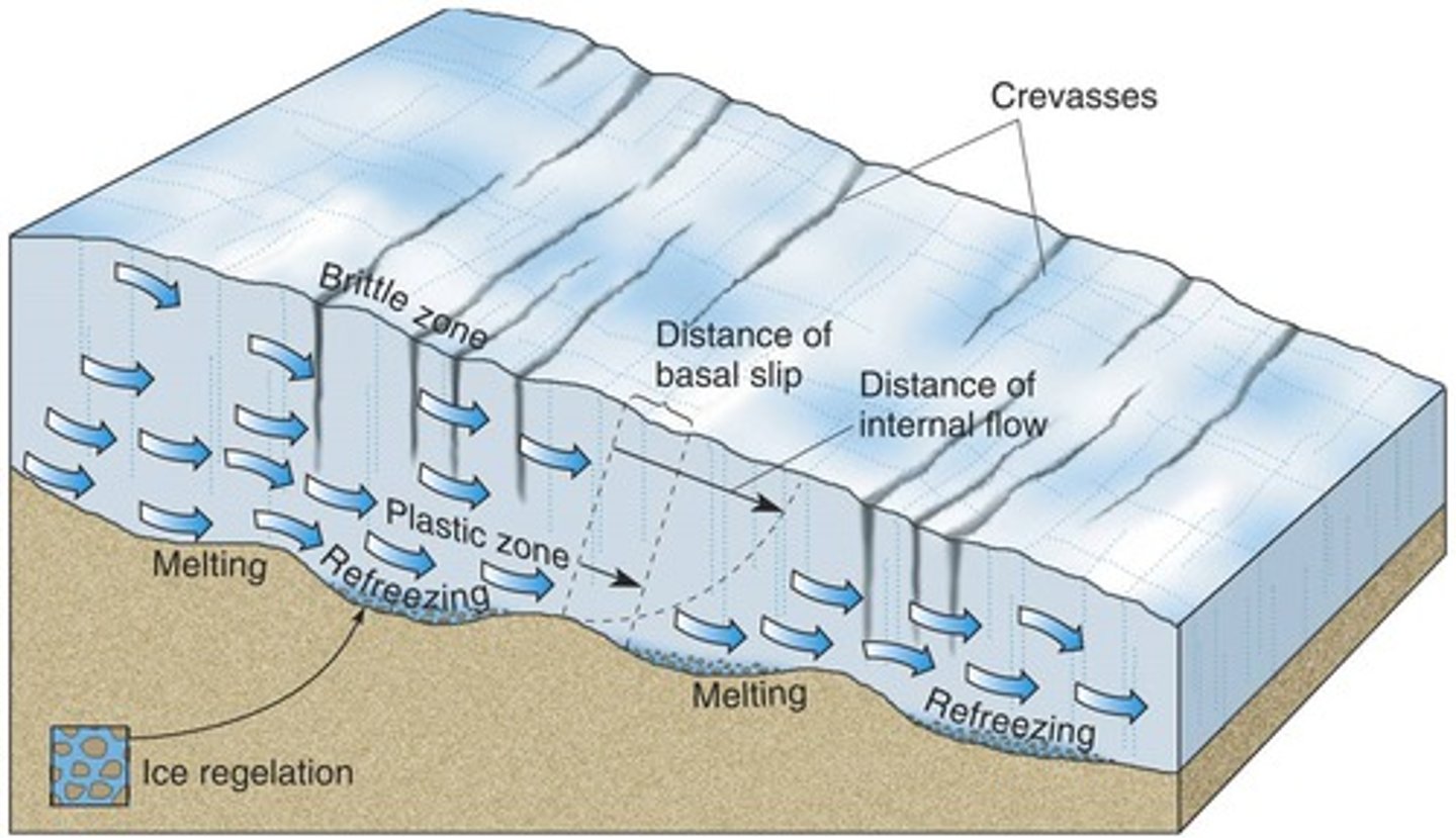
Basal sliding
Glaciers move differently depending on the temperature of the ice at their base.
Warm-based (temperate) glaciers mainly move by basal sliding. If the basal temperature is at or above pressure melting point a thin film of meltwater exists between the ice and the valley floor and so friction is reduced.
Basal sliding actually consists of a combination of different mechanisms: Slippage, Creep or regelation, Bed deformation.
Slippage (Basal sliding)
Where the ice slides over the valley floor as the meltwater has reduced friction between the base of the glacier (and any debris embedded in it) and the valley floor. Friction itself between the moving ice/debris and the valley floor can also lead to the creation of meltwater.
Creep or regelation (Basal sliding)
When ice deforms under pressure due to obstructions on the valley floor. This enables it to spread around and over the obstruction, rather as a plastic, before re-freezing again when the pressure is reduced.
Bed deformation (Basal sliding)
When the ice is carried by saturated bed sediments moving beneath it on gentle gradients. The water is under high pressure. This movement has been likened to the ice being carried on roller skates.
Internal deformation
Cold-based (polar) glaciers are unable to move by basal sliding as the basal temperature is below pressure melting point. Instead they move mainly by internal deformation, although ice at 0ºC deforms 100 times faster than ice at -20ºC.
Internal deformation has two elements: Intergranular flow, Laminar flow. Both of these movements occur when the glacier is on a slope; they do not occur on level surfaces where the ice remains intact.
Intergranular flow (Internal deformation)
When individual ice crystals re-orientate and move in relation to each other.
Laminar flow (Internal deformation)
When there is movement of individual layers within the glacier - often layers of annual accumulation.
Example of Internal deformation
The Meserve glacier in Antarctica moves only 3-4 m per year at its equilibrium line and 100% of this movement is by internal deformation.
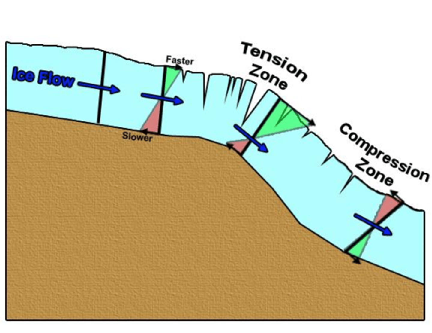
When ice moves over a steep slope it is unable to deform quickly enough and so it fractures, forming crevasses. The leading ice pulls away from the ice behind it, which has yet to reach the steeper slope.
This is extending flow.
Extending and compressing flow
Page 46.
2.2 How are glacial landforms developed?
Key idea ⮕ Glaciated landforms develop due to a variety of interconnected climatic and geomorphic processes.
Geomorphic processes
-Weathering (Physical or mechanical, Chemical, Biological)
-Mass movement (Rock fall, Slides)
-Glacial processes (Erosion, Nivation, Transportation, Deposition, Till)
Weathering
A ubiquitous process in that it happens everywhere. In glacial areas some types of weathering are particularly significant and therefore influence the formation of glacial landforms.
Physical or mechanical (Weathering)
The breakdown of rock is largely achieved by physical weathering processes that produce smaller fragments of the same rock. No chemical alteration takes place during physical weathering. By increasing the exposed surface area of the rock, physical weathering allows further weathering to take place.
Freeze-thaw (Physical or mechanical Weathering)
Water enters cracks/joints and expands by nearly 10% when it freezes. In confined spaces this exerts pressure on the rock causing it to split or pieces to break off, even in very resistant rocks. The more frequent and regular the fluctuations of temperature around zero, the more effective this process will be.
Frost shattering (Physical or mechanical Weathering)
At extremely low temperatures, water trapped in rock pores freezes and expands. This creates stress which disintegrates rock to small particles.
Pressure release (Physical or mechanical Weathering)
When the weight of overlying ice in a glacier is lost due to melting, the underlying rock expands and fractures parallel to the surface. This is significant in the exposure of sub-surface rocks such as granite and is also known as dilatation. The parallel fractures are sometimes called pseudo-bedding planes.
Chemical (Weathering)
Decay of rock is the result of chemical weathering, which involves chemical reaction between the elements of the weather and some minerals within the rock. It may reduce the rock to its chemical constituents or alter the chemical and mineral composition of the rock. Chemical weathering processes produce weak residues of different material that may then be easily removed by erosion or transportation processes.
The rate of most chemical reactions is faster when temperature is higher - see Van't-Hoff's Law.
Van't-Hoff's Law
States that a 10°C increase in temperature leads to a 2.5 times increase in the rate of chemical reaction (up to 600°C), so most chemical weathering processes are most effective in warm or hot climatic regions. This is why warm, moist tropical environments experience the fastest rates of chemical weathering and cold, dry ay ocesses spued locations the slowest.
Oxidation (Chemical Weathering)
Some minerals in rocks react with oxygen, either in the air or in water. Iron is especially susceptible to this process. It becomes soluble under extremely acidic conditions and the original structure is destroyed. It often attacks the iron-rich cements that bind sand grains together in sandstone.
Carbonation (Chemical Weathering)
Rainwater combines with dissolved carbon dioxide from the atmosphere to produce a weak carbonic acid. This reacts with calcium carbonate in rocks such as limestone to produce calcium bicarbonate, which is soluble. This process is reversible and precipitation of calcite happens during evaporation of calcium rich water in caves to form stalactites and stalagmites.
Solution (Chemical Weathering)
Some salts are soluble in water. Other minerals, such as iron, are only soluble in very acidic water, with a pH of about 3. Any process by which a mineral dissolves in water is known as solution, although mineral specific processes, such as carbonation, can be identified.
Hydrolysis (Chemical Weathering)
This is a chemical reaction between rock minerals and water. Silicates combine with water producing secondary minerals such as clays. Feldspar in granite reacts with hydrogen in water to produce kaolin (china clay).
Hydration (Chemical Weathering)
Water molecules added to rock minerals create new minerals of a larger volume. This happens to anhydrite forming gypsum. Hydration causes surface flaking in many rocks, partly because some minerals also expand by about 0.5% during the chemical change as well because they absorb water.
Biological (Weathering)
Biological weathering may consist of physical actions such as the growth of plant roots or chemical processes such as chelation by organic acids. Although this, arguably, does not fit with the precise definition of weathering, biological processes are usually classed as a type of weathering. Certainly the effects are very similar to some of the physical and chemical processes even if it may be difficult to directly relate them to the weather.
In glacial environments, plant and animal activity may be severely limited by the low temperatures and so these mechanisms may be of very little significance.
Tree roots (Biological Weathering)
Tree roots grow into cracks or joints in rocks and exert outward pressure. This operates in a very similar way and with similar effects to freeze-thaw. When trees topple, their roots can also exert leverage on rock and soil, bringing them to the surface and exposing them to further weathering. Burrowing animals may have a sìmilar effect.
Organic acids (Biological Weathering)
Organic acids produced during decomposition of plant and animal litter cause soil water to become more acidic and react with some minerals in a process called chelation. Blue-green algae can have a weathering effect, producing a shiny film of iron and manganese oxides on rocks.
Mass movement
Mass movement occurs when the forces acting on slope material (mainly the resultant force of gravity) exceed the forces trying to keep the material on the slope (predominantly friction). In glacial landscape systems, the most significant mass movement processes are those acting on steep slopes, which lead to the addition of material to the glacier below, loading it with debris and providing the tools for abrasion.
Rock fall (Mass movement)
On slopes of 40° or more, especially if the surface is bare, rocks may become detached from the slope by physical weathering processes. These then fall to the foot of the slope under gravity. Transport processes may then remove this material, or it may accumulate as a relatively straight, lower angled scree slope.
Slides (Mass movement)
These may be linear, with movement along a straight line slip plane, such as a fault or a bedding plane between layers of rock, or rotational, with movement taking place along a curved slip plane. Rotational slides are also known as slumps. In glaciated landscape systems, slides may occur due to steepening or undercutting of valley sides by erosion at the base of the slope, adding to the downslope forces. Slumps are common in weak rocks, such as clay, which also become heavier when wet, adding to the downslope force.
Glacial processes
Moving ice in a glacier is a source of energy in glaciated landscape systems, and the energy can be expended through geomorphic processes to shape landforms. These processes can also supply material in the form of sediment, which can be deposited in, or transported within, the glacial system.
Erosion (Glacial processes)
Glacial erosion occurs as glaciers advance and this mainly occurs in upland areas. There are two main processes of erosion by glaciers:
-Plucking
-Abrasion.
Plucking (Erosion (Glacial processes))
This mainly happens when meltwater seeps into joints in the rocks of the valley floorl sides. This then freezes and becomes attached to the glacier. As the glacier advances it pulls pieces of rock away. A similar mechanism takes place when ice re- freezes on the down-valley side of rock obstructions. Plucking is particularly effective at the base of the glacier as the weight of the ice mass above may produce meltwater due to pressure melting. It will also be significant when the bedrock is highly jointed which allows meltwater to penetrate. Plucking is also known as quarrying.
Abrasion (Erosion (Glacial processes))
the debris embedded in its base/sides scours surface rocks, wearing them away. The process is often likened to the action of sandpapering. The coarse material will scrape, scratch and groove the rock. The finer material will tend to smooth and polish the rock. The glacial debris itself is also worn down ially if the ed from These vity. material, lower and therefor if the waten is confined o Bupis • determines long Suipp ne. pappaqua as a glacier moves across the surface, greater the due to osion per unit pe Movemen not only the basal gacial en
Factors that affect glacial abrasion (Erosion (Glacial processes))
-Presence of basal debris
-Debris size and shape
-Relative hardness of particles and bedrock
-Ice thickness
-Basal water pressure
-Sliding of basal ice
-Movement of debris to the base
-Removal of fine debris
More information can be found on page 49.
Estimates of rates of erosion (Erosion (Glacial processes))
-Embleton and King (1968) suggest that mean annual erosion for active valley glaciers is between 1000 and 5000 m³.
-Boulton (1974) measured erosion on rock plates placed beneath the Breiðamerkurjökull glacier in Iceland and found that under ice 40 m thick, basalt eroded at 1 mm per year and marble at 3 mm per year. The ice had a velocity of 9.6 m per year. However, if the velocity increased to 15.4 m/year, the rate of erosion of marble increased to 3.75 mm, even though the ice was 8 m thinner. In this instance it would suggest that velocity is more important than ice thickness.
-In comparison, ice 100 m thick flowing at 250 m per year in the Glacier d'Argentière eroded a marble plate at up to 36 mm/year.
Nivation (Glacial processes)
A glacial process that is not easily classified as erosion or weathering. This complex process is thought to include a combination of freeze-thaw action, solifluction, transport by running water and, possibly, chemical weathering. Nivation is thought to be responsible for the initial enlargement of hillside hollows and the incipient development of carries.
Sources of Transportation (Glacial processes)
-Rockfall - weathered debris falls under gravity from the exposed rock above the ice down onto the edge of the glacier.
-Avalanches - these often contain rock debris within the snow and ice that moves under gravity.
-Debris flows - in areas of high precipitation and occasional warmer periods, melting snow or ice can combine with scree, soil and mud.
-Aeolian deposits - fine material carried and deposited by wind, often blowing across outwash deposits.
-Plucking - large rocks plucked from the side and base of valleys
-Abrasion - smaller material worn away from valley floors and sides
Transportation (Glacial processes)
Moving ice is capable of carrying huge amounts of debris. This material comes from a wide range of sources.
How material in Transportation may be classified (Glacial processes)
-Superglacial is debris being carried on the surface of a glacier. This will most often come from weathering and rockfall.
-Englacial is debris within the ice. This may have been supra glacial material that has been covered by further snowfall, fallen into crevasses or sunk into the ice due to localised pressure melting.
-Subglacial is debris embedded in the base of the glacier which may have been derived from plucking and abrasion, or that has continued to move down through the ice as former englacial debris.
Deposition (Glacial processes)
Glaciers deposit their load when their capacity to transport material is reduced. This usually occurs as a direct result of ablation during seasonal periods of retreat or during de-glaciation. However, material can also be deposited during advance or when the glacier become overloaded with debris.
Till (Deposition (Glacial processes))
-Lodgment till - material deposited by advancing ice. Due to downward pressure exerted by thick ice, subglacial debris may be pressed and pushed into existing valley floor material and left behind as the ice moves forward. This could be enhance by localised pressure melting around individual particles that are under significant weight and pressure. Drumlins are the main example of landforms of this type.
-Ablation till - material deposited by melting ice from glaciers that are stagnant or in retreat, either temporarily during a warm period or at the end of the glacial event. Most glacial depositional landforms are of this type
Glacial outwash
Sediment deposited by meltwater streams emanating from a glacier.
Glacio-fluvial
Relating to meltwater from a glacier.
Glacial drift
The general term for all of the materials carried and deposited by a glacier
Three distinctive characteristics of till (Deposition (Glacial processes))
-Angular or sub-angular in shape because it has been embedded in the ice and has not been further eroded
-Unsorted - all sizes are deposited en masse, together. When water deposits material, it loses energy progressively and deposits material in a size-based sequence.
-Unstratified is where glacial till is dropped in mounds and ridges rather than in layers, which is typical of water-bourne deposits.
Glacial landforms
-Erosional (Corries, Arêtes and pyramidal peaks, Troughs, Roche mountonnées and striations, Ellipsoidal basins)
-Depositional (Moraines, Erratics, Drumlins, Till sheets)
Erosional (Glacial landforms)
-Corries
-Arêtes and pyramidal peaks
-Troughs
-Roche mountonnées and striations
-Ellipsoidal basins
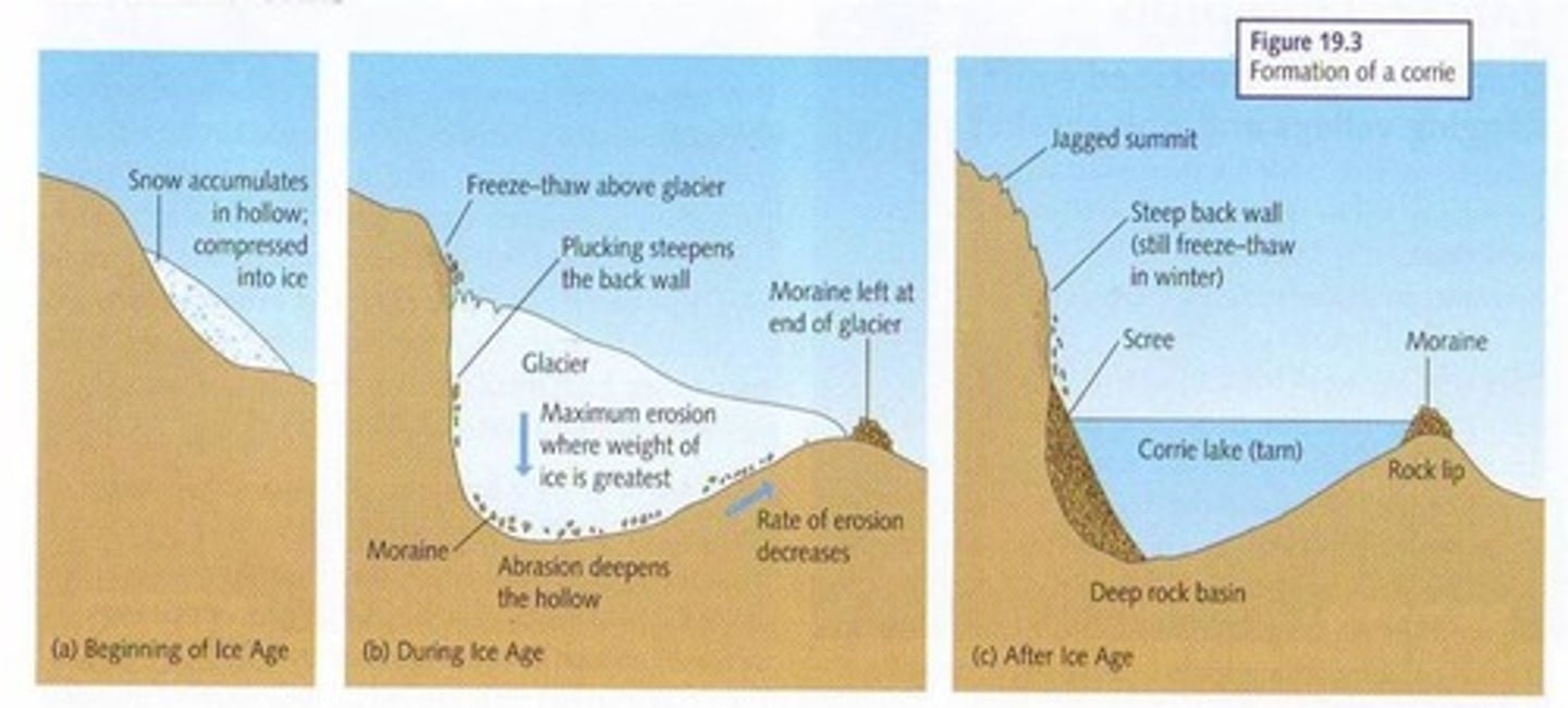
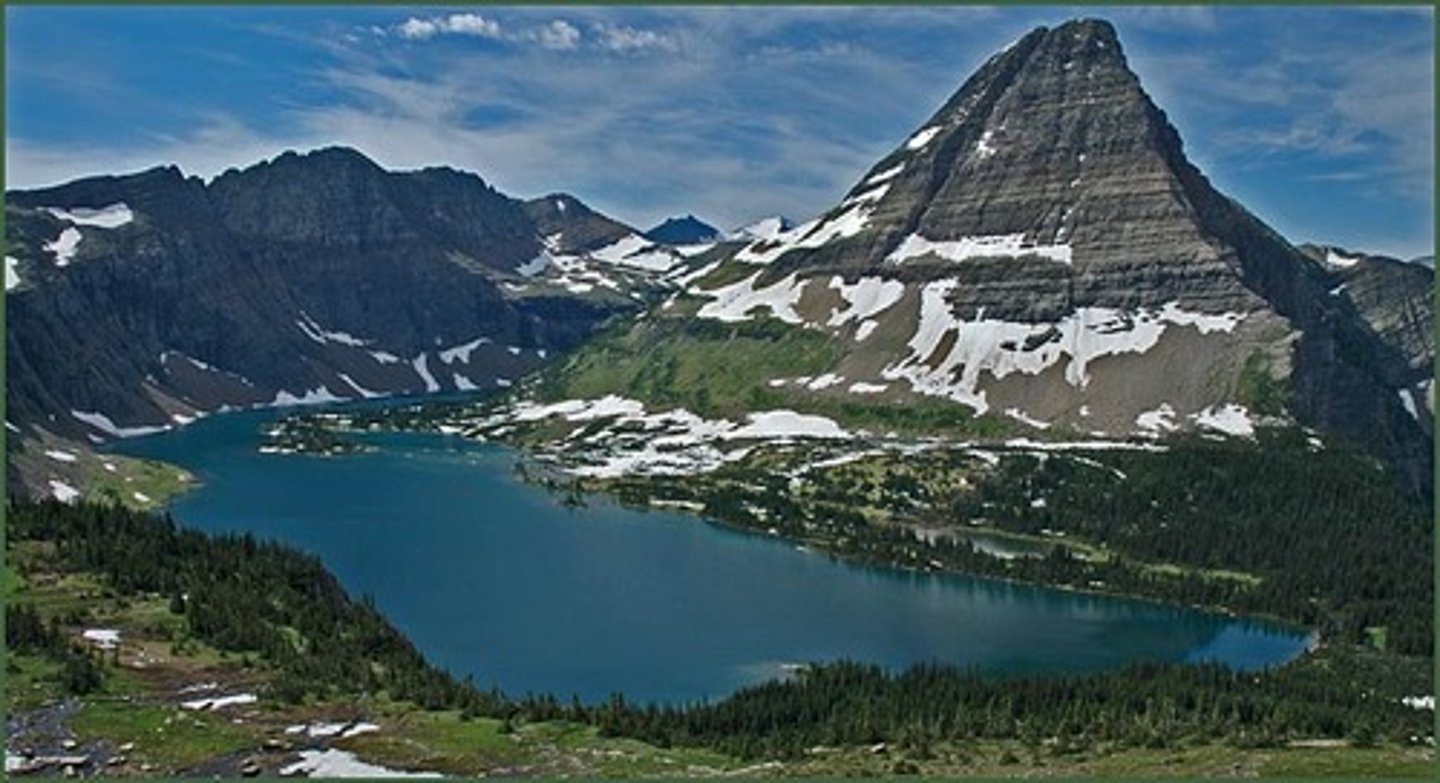
Corries (Erosional (Glacial landforms))
Armchair-shaped hollows found on upland hills or mountainsides. They have a steep back wall, an over-deepened basin and often have a lip at the front which may be solid rock or made of morainic deposits.
Corries (Erosional (Glacial landforms)) (Diagram)
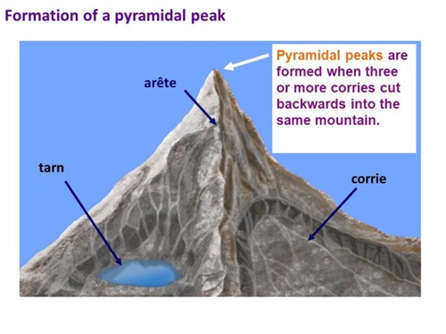
Arêtes and pyramidal peaks (Erosional (Glacial landforms))
An arête is a narrow, steep-sided ridge found between two carries. The ridge is often so narrow that it is described as kinfe-edged. Arêtes form glacial erosion, with the steepening of slopes and the retreat of corries that are back to back or alongside each other.
Where three or more corries develop around a hill or mountain top and their back walls retreat, the remaining mass will be itself steepened to form a pyramidal peak. Weathering of the peak may further sharpen its shape. The Matterhorn in the Swiss Alps is an excellent example and is over 1,200 m high.
Arêtes and pyramidal peaks (Erosional (Glacial landforms)) (Located example)
Striding Edge in the Lake District which has steep slopes either side that are 200-300 m high and almost vertical in places. Striding Edge itself is so narrow that it is just wide enough for one person to walk along the footpath that runs along the crest towards the summit of Helvellyn.
Arêtes and pyramidal peaks (Erosional (Glacial landforms)) (Diagram)
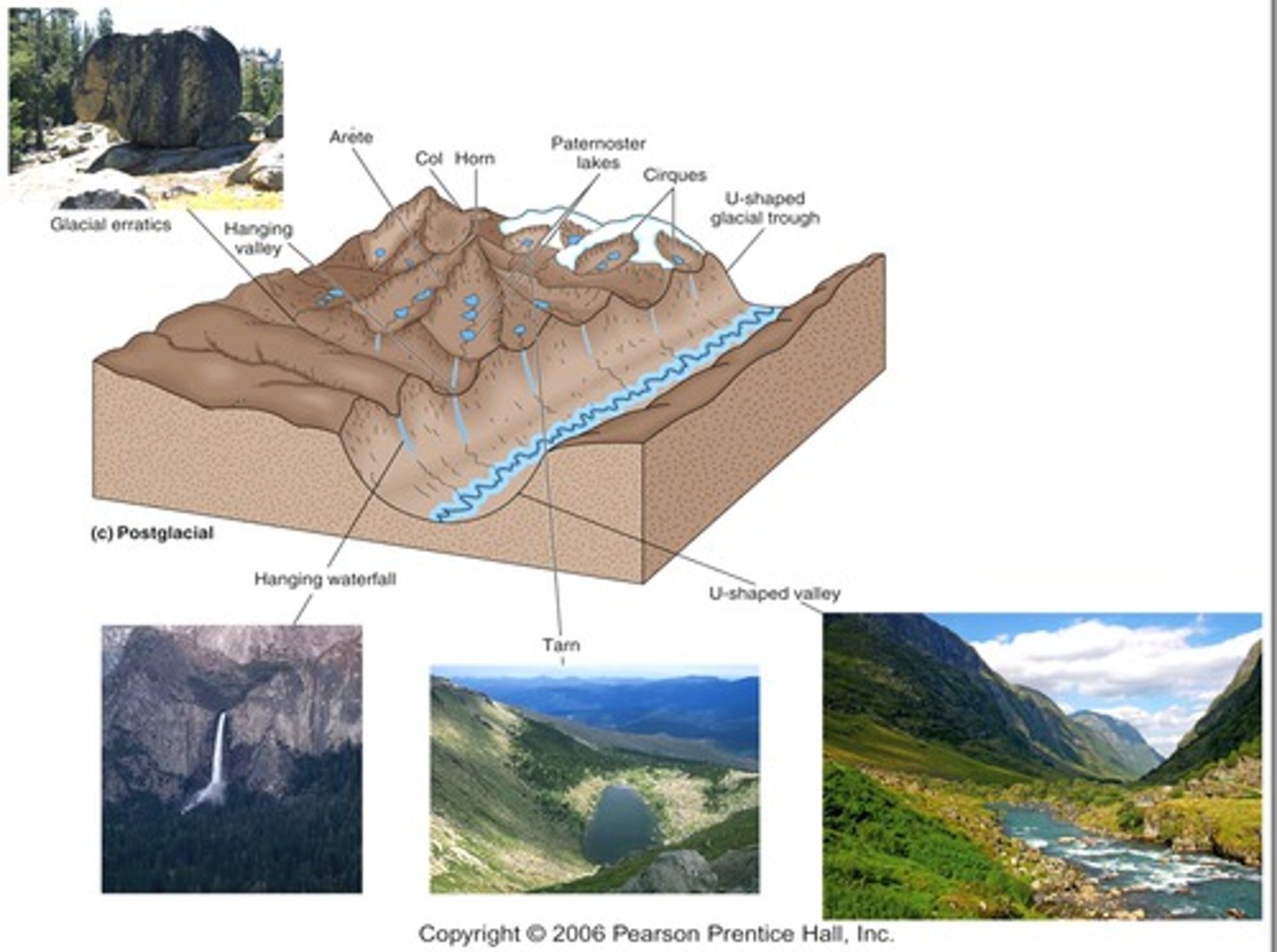
Troughs (Erosional (Glacial landforms))
Glaciers flow down pre-existing river valleys under gravity. As they move they erode the sides and floor of the valley, causing the shape to become deeper, wider and straighter. The mass of ice has far more erosive power than the river that originally cut the valley. Although they are usually described as being U-shaped, they seldom are. Rather, they are parabolic, partly due to the weathering and mass movement of the upper part of the valley sides that goes on both during the glacial period and in the subsequent periglacial period as the glacier retreats.
Troughs (Erosional (Glacial landforms)) (Diagram)
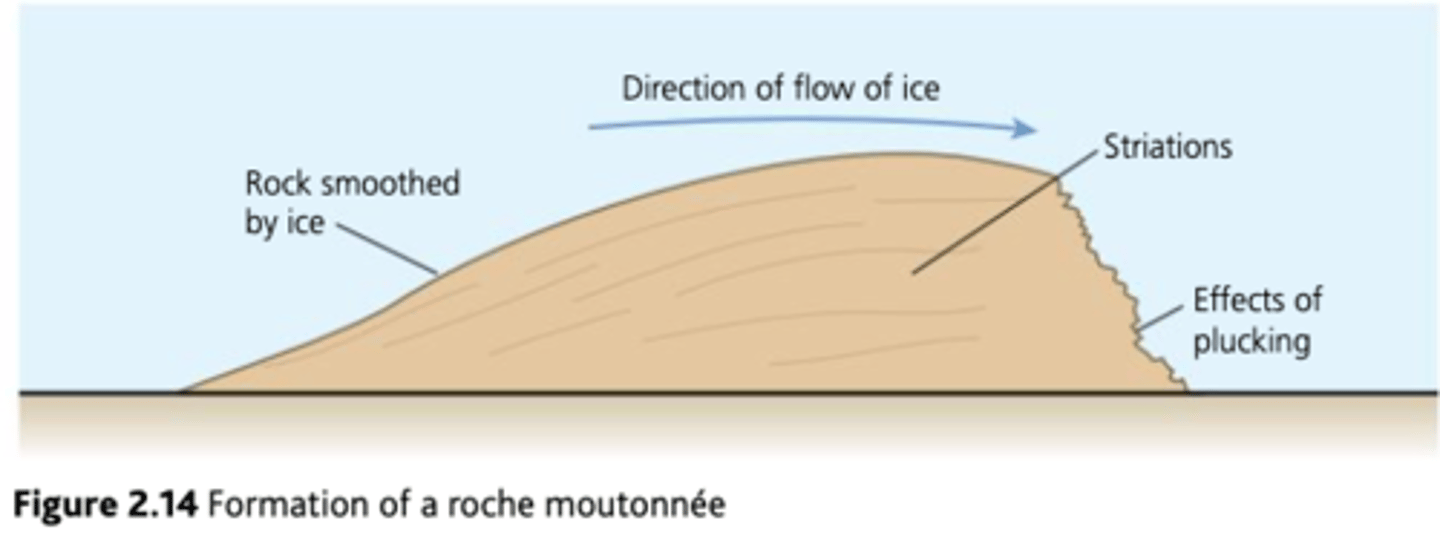
Roche mountonnées and striations (Erosional (Glacial landforms))
Projections of resistant rocks are sometimes found on the floor of glacial troughs.
As advancing ice passes over them, there is localised pressure melting on the up-valley side. This area is smoothed and streamlined by abrasion and often has striations which are scratches or grooves made by debris embedded in the base of the glacier.
On the down-valley side pressure is reduced and meltwater re-freezes, resulting in plucking and steepening. Roche mountonnées can indicate the direction the ice moved through an area. They vary in size but in the Coniston area of the Lake District they are typically 1-5 m high and 5-20 m long.
Roche mountonnées and striations (Erosional (Glacial landforms)) (Diagram)
Ellipsoidal basins (Erosional (Glacial landforms))
All of the erosional glacial landforms are formed by the action of valley glaciers and their tributaries. This is known as Alpine glaciation. Significant contrasts can be seen when looking at the impact of large ice sheets on the landscape. Ellipsoidal basins are major erosional landforms created by ice sheets. The Laurentide ice sheet covered much of North America between about 95,000 and 12,000 years ago.
Ellipsoidal basins (Erosional (Glacial landforms)) (Diagram)
Depositional (Glacial landforms)
A number of different landforms are produced by sediment being directly deposited by ice:
-Moraines
-Erratics
-Drumlins
-Till sheets
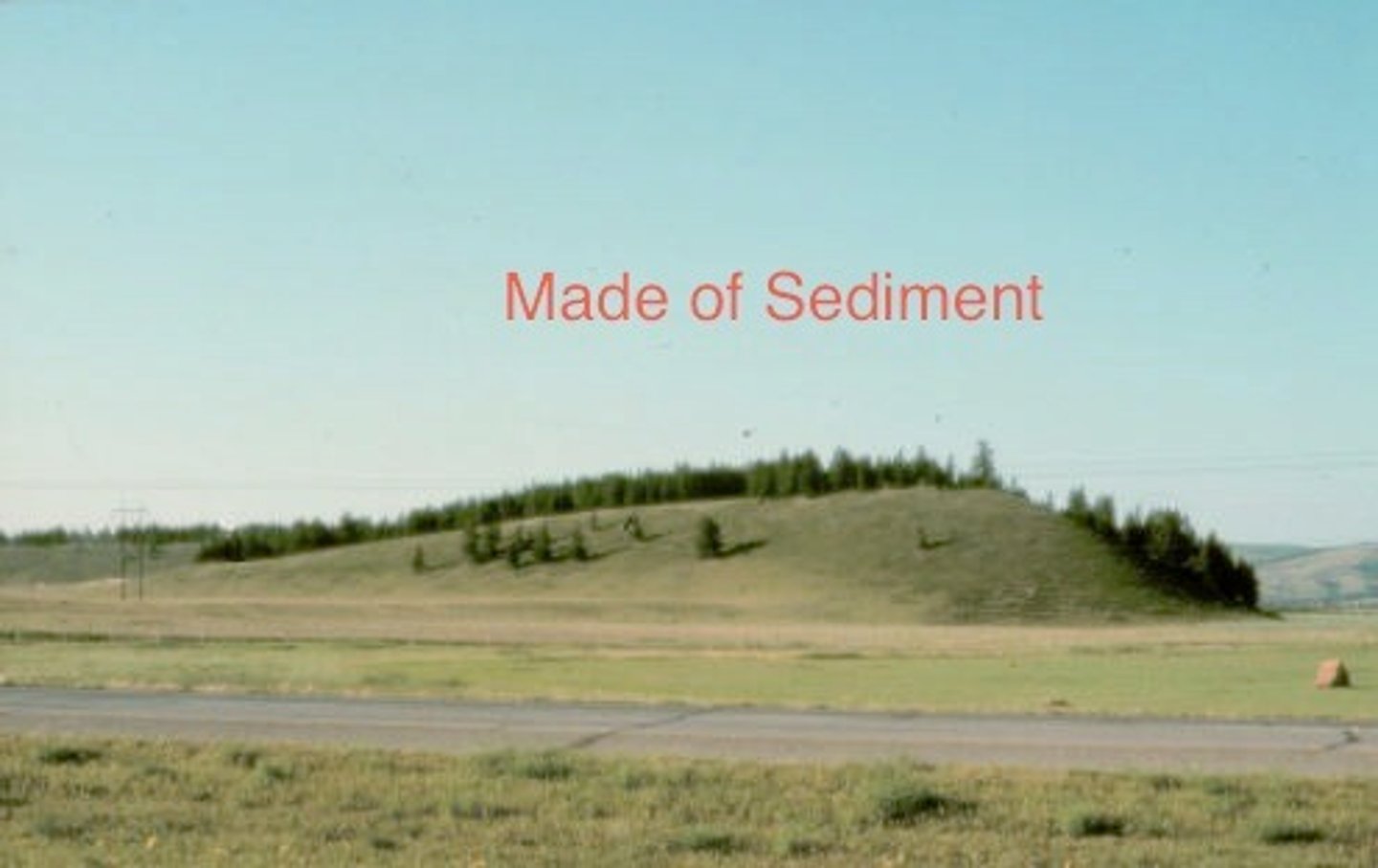
Moraines (Depositional (Glacial landforms))
A terminal moraine is a ridge of till extending across a glacial trough. They are usually steeper on the up-valley side and tend to be crescent shaped, reaching further down-valley in the centre. These landforms mark the position of the maximum advance of the ice and were deposited at the glacier snout. Their crescent shape is die to the position of the snout; further advance occurs in the centre of the glacier, as there is no friction with the valley sides.
Moraines (Depositional (Glacial landforms)) (Diagram)
Lateral moraine (Depositional (Glacial landforms))
A ridge of till along the edge of a glacial valley composed primarily of debris that fell to the glacier from the valley walls.
Recessional moraines (Depositional (Glacial landforms))
A series of ridges running transversely across a glacial trough.
Terminal moraine
A cross-valley, ridge-like accumulation of glacial sediment that forms at the farthest point reached by the terminus of an advancing glacier.
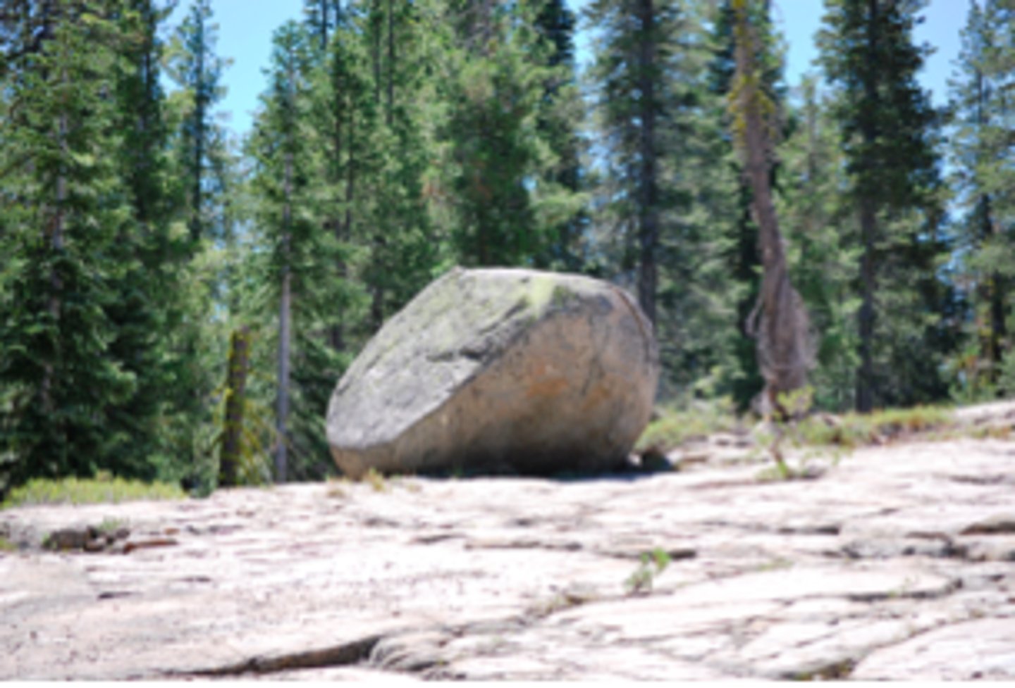
Erratics (Depositional (Glacial landforms))
An individual piece of rock, varying in size from a small pebble to a large boulder. These are distinctive because of a different geological composition from that of the area in which they have been deposited. They were eroded, most likely by plucking, or added to the supraglacial debris by weathering and rockfall, in an area of one type of geology and then transported and deposited into an area of differing rock type.
Erratics (Depositional (Glacial landforms)) (Diagram)
Drumlins (Depositional (Glacial landforms))
A mound of glacial debris that has been streamlines into an elongated hill. Often they are prominent landforms, sometimes more than 1 km in length and 100 m high. In plan they are typically pear-shaped and aligned in the direction of the ice flow. The higher and wider stoss, or blunt, end faces the ice flow, while the lee side is more gently tapered.
Why Drumlins may be formed (Depositional (Glacial landforms))
-Lodgement of subglacial debris as it melts out of the basal ice layers.
-Reshaping of previously deposited material during a subsequent re-advance.
-Accumulation of material around a bedrock obstruction - these are known as rock-cored drumlins.
-Thinning of ice as it spread out over a lowland area, reducing its ability to carry debris.
Drumlins (Depositional (Glacial landforms)) (Diagram)
Till sheets (Depositional (Glacial landforms))
Formed when a large mass of unstratified drift is deposited at the end of a period of ice sheet advanced, which smooths the underlying surface. They may not be very conspicuous in terms of relief, but they are significant landforms because of their extent.
Till sheets (Depositional (Glacial landforms)) (Diagram)
Case study
Pages 56-59. Read through twice and ensure understanding of all processes and landforms.
2.3 How do glacial landforms evolve over time as climate changes?
Key idea ⮕ Glacis-fluvial landforms exist as a result of climate change at the end of glacial periods.