APHUG Unit 6
0.0(0)
Card Sorting
1/150
Earn XP
Description and Tags
Last updated 11:03 PM on 3/19/23
Name | Mastery | Learn | Test | Matching | Spaced | Call with Kai |
|---|
No analytics yet
Send a link to your students to track their progress
151 Terms
1
New cards
Ecumene
What the classical Greeks called the permanently inhabited portion of the earth’s surface
2
New cards
Rural
Farmers and villages with low concentrations of people
3
New cards
Urban
Cities with high concentrations of people
4
New cards
Suburbs
Primarily residential areas near cities
5
New cards
Settlement
Place with permanent human population
6
New cards
Factors driving urbanization
\-Agricultural surplus→ irrigation, farming, domestication = more people living in the same place
\
\-Rise of social stratification and leadership class→ control products and people
\
\-Job specialization→ Cities = econ. centers of services, manufacturing, and trade
\
\-Rise of social stratification and leadership class→ control products and people
\
\-Job specialization→ Cities = econ. centers of services, manufacturing, and trade
7
New cards
Urbanization
One of the most important phenomena of 19th and 20th century. Process of developing towns and cities. Involves causes and effects of existing cities’ growth.
8
New cards
Percent Urban
Indicator of proportion of population that lives in cities and towns vs. rural areas.
9
New cards
Site
Characteristics of an immediate location
10
New cards
Situation
Location of a place relative to its surroundings and its connectivity to other places.
11
New cards
City-state
Has urban center(city) and surrounding territory and agricultural villages. Own political system and functions independently. Services and protection is from urban center. Often raided by other groups for wealth so→ defense = primary consideration. Military leaders became political leaders and kings.
12
New cards
Urban Hearth
Area generally associated with defensible sites and river valleys where seasonal floods and fertile soils allowed for an agricultural surplus.
\
\-Tigris-Euphrates Valley(Mesopotamia) in modern Iraq
\-Nile River Valley and Nile Delta in modern Egypt
\-Indus River Valley in modern Pakistan
\-Huang-He floodplain in modern China
\
\-Tigris-Euphrates Valley(Mesopotamia) in modern Iraq
\-Nile River Valley and Nile Delta in modern Egypt
\-Indus River Valley in modern Pakistan
\-Huang-He floodplain in modern China
13
New cards
Urban area
Central city plus land developed for commercial, industrial, or residential purposes, and includes the surrounding suburbs.
14
New cards
City
Higher-density area with territory inside officially recognized political boundaries
15
New cards
Metropolitan Area(metro area)
Collection of adjacent cities economically connected, across which population density is high and continuous.
16
New cards
Metropolitan Statistical Area(MSA)
Another way to define a city. City of at least 50,000 people, the county in which it’s located, and adjacent counties that have a high degree of social and econ. integration of connection with the urban core.
17
New cards
Micropolitan Statistical Area
Over 10,000 people but less than 50,000, includes the county where it’s located and surrounding counties with high degree of integration.
18
New cards
Nodal Region
Focal point in a matrix of connections
19
New cards
Morphology
Physical characteristics to describe an urban area.
20
New cards
Population characteristics of cities
\-Social heterogeneity→ pop. of city has greater variety of people
\-Immigration→ centers of immigration(40% or more foreign born in large cities)
\-Diversity→ from high pop. density and relative anonymity of cities. Leads to more diversity(cities attract those with less common cultures, more likely to find others like them in cities).
\-Immigration→ centers of immigration(40% or more foreign born in large cities)
\-Diversity→ from high pop. density and relative anonymity of cities. Leads to more diversity(cities attract those with less common cultures, more likely to find others like them in cities).
21
New cards
Time-space compression
(Past vocab, 1.4) Shrinking of time distance or relative distance based on improvements in transportation and internet.
22
New cards
Borchert’s transportation model
Geographer John Borchert
Describes urban growth based on transportation technology.
Urban history split into 4 periods: Epochs→ effects on local scale related to city’s form, size, density and spatial arrangement.
Describes urban growth based on transportation technology.
Urban history split into 4 periods: Epochs→ effects on local scale related to city’s form, size, density and spatial arrangement.
23
New cards
Transportation’s impacts on cities
Horse and buggy→ city size ↑, streetcar systems→ city size ↑↑, automobile = ↑↑↑, lower density suburbs around original cities→ separate cities(part of metro area).
24
New cards
Pedestrian Cities
Earliest urban centers. Shaped by distances people could walk.
25
New cards
Streetcar Suburbs
Communities that grew up along rail likes, often = pinwheel shaped.
26
New cards
Communication’s impact on cities
Historically→ cities connected to trade routes = got info first
Early adopting cities benefit w/ telecommunication tech.
Early 2000s, cities lagging in building communications infrastructure fell behind. Now, it’s essential to attract big companies.
Cities = nodal regions, need connectivity to thrive
Communications tech = hierarchical diffusion
Early adopting cities benefit w/ telecommunication tech.
Early 2000s, cities lagging in building communications infrastructure fell behind. Now, it’s essential to attract big companies.
Cities = nodal regions, need connectivity to thrive
Communications tech = hierarchical diffusion
27
New cards
Pop. and migration’s impact on cities
Rapid growth uses resources and makes issues for cities. (Substandard housing, overcrowding, and stressed infrastructure).
Past 100 years = billions→ rural-to-urban→ most rapid today: semi-periphery and periphery(China, India, Brazil) and much of it = domestic(within the country).
Core countries: slowed rural-to-urban but domestic and international
Past 100 years = billions→ rural-to-urban→ most rapid today: semi-periphery and periphery(China, India, Brazil) and much of it = domestic(within the country).
Core countries: slowed rural-to-urban but domestic and international
28
New cards
Econ. development and gov. policies’ impacts on cities
Cities seen as engines of growth for countries’ economy
So policies = guide and encourage city growth
Major cities usually have econ. functions but they can change too.
Local policies to make econ. incentives:
-low-cost loans
-lower tax
-cheap land
\
Ex. Shenzhen in China(2014, New Urbanization Plan)
So policies = guide and encourage city growth
Major cities usually have econ. functions but they can change too.
Local policies to make econ. incentives:
-low-cost loans
-lower tax
-cheap land
\
Ex. Shenzhen in China(2014, New Urbanization Plan)
29
New cards
Suburbanization
Process of people moving(usually from cities) to residential areas on outskirts of cities. Form communities connected to city or jobs and services.
30
New cards
Causes of USA suburbanization
\-Econ. expansion
\- ↑ purchasing power
\- ↑ car-centered life
\-highways
\
U.S: mortgage loans to families moving to suburbs.
\- ↑ purchasing power
\- ↑ car-centered life
\-highways
\
U.S: mortgage loans to families moving to suburbs.
31
New cards
Sprawl
Rapid expansion of the spatial extent of a city and occurs for many reasons(growth of suburbs, ↓ land costs in suburbs vs. inner cities, ↓ density single family housing, weak planning laws, ↑ growth of car culture). ↑ urban footprint. Most common in fast growing areas in the Southeast and West.
32
New cards
Leap-frog development
Developers purchase land and build communities beyond the periphery of a city’s built area. Encourages sprawl.
33
New cards
Boombergs
Rapidly growing communities w/ total pop. of over 100,000 people but not largest city in metro area. Develops differently than traditional cities— usually no dense urban center.
Ex. Plano
Ex. Plano
34
New cards
Edge cities
Nodes of econ. activity that developed in the periphery of large cities. Found near key locations along transport routes that have mini downtowns.
35
New cards
Counterurbanization(deurbanization)
Urban migrants leaving city(counterflow of rural-to-urban), many to exurbs.
36
New cards
Exurbs
Prosperous residential districts beyond the suburbs. Growth reasons: work w/ tech = no need to commute(can live farther), relative affordability of land, cultural preferences. Residents want privacy and connections to urban center. Expansive lots and large single family homes.
37
New cards
Reurbanization
Migration of suburbs back to city
38
New cards
Megacities
Pop. is greater than 10 million people.
39
New cards
Metacities
Because of rapid growth of cities in the 21st century. Also, hypercities. Continuous urban area w/ a pop. > 20 mil. people. Attributes of a network of urban areas that have grown to form a larger interconnected urban system.
40
New cards
Megalopolis
Chain of connected cities. More commonly used as a term after 1961. Cities grow until merged into conurbation. Crossed state boundaries and exceeded definition of metropolitian area while focused on one urban center.
41
New cards
Conurbation
Uninterrupted area of towns, suburbs, and cities.
42
New cards
Trend of urbanization in the developing world
Before: megacities only at centers of large empires/most powerful countries.
Now: more common in LDCs(= ↑ CBR and rural to urban)
2020→ 20 of largest urban areas in the world, 15= periphery/semi-periphery countries.
Megacities everywhere have same problems but # of resources available to respond depend on level of development/econ. level.
Now: more common in LDCs(= ↑ CBR and rural to urban)
2020→ 20 of largest urban areas in the world, 15= periphery/semi-periphery countries.
Megacities everywhere have same problems but # of resources available to respond depend on level of development/econ. level.
43
New cards
World(global) cities
Exert influence far beyond national boundaries.
Ex. NYC, London, Tokyo, and Paris
Ex. NYC, London, Tokyo, and Paris
44
New cards
Urban Hierarchy
City’s ranking based on influence and pop. size
45
New cards
Top 10 World Cities 2020
1. London, England
2. NYC, U.S
3. Tokyo, Japan
4. Paris, France
5. Singapore
6. Amsterdam, Netherlands
7. Berlin, Germany
8. Seoul, South Korea
9. Hong Kong, China
10. Shanghai, China
46
New cards
Nodal Cities
Command centers on a regionally and occasionally national level.
Ex. Denver, Phoenix, Minneapolis
Ex. Denver, Phoenix, Minneapolis
47
New cards
Urban Systems
Interdependent set of cities that interact on the regional, national, and global scale.
48
New cards
Rank-size Rule
Describes one way in which the size of cities within a region may develop. Nth largest city in any region would be 1/n the size of the largest city. Rank of city within an urban system will predict the size.
49
New cards
Rank size distribution
Characteristics of a well-developed region/country. Also more common in places where federal government shares power w/ other levels of gov.
General rule: indicator of urban system that can efficiently provide needed services to its pop.
General rule: indicator of urban system that can efficiently provide needed services to its pop.
50
New cards
High-order services
Usually expensive, need big number of people to support, and only occasionally utilized.
Ex. Major sports teams, big malls, luxury car dealerships, and big specialized research hospitals.
Ex. Major sports teams, big malls, luxury car dealerships, and big specialized research hospitals.
51
New cards
Low-order services
Less expensive, needs small pop. to support, and used daily/weekly.
Ex. Gas stations, local grocery stores, and small restaurants.
Ex. Gas stations, local grocery stores, and small restaurants.
52
New cards
Primate Cities
If largest city in an urban system is more than twice as large as the next largest city. Often w/ countries that follow a unitary form of gov, or extremely strong central gov.
53
New cards
Gravity Model
Says that larger and closer will have more interactions than places that are smaller and predicts flow of workers, shoppers, migrants, vacationers, info, mail, products, econ. activity, etc.
Limits: Not accounting for physical, cultural, and pol. barriers’ influence.
Limits: Not accounting for physical, cultural, and pol. barriers’ influence.
54
New cards
Central Place Theory
1933, Walter Christaller, German, explains distribution of cities of different sizes across a region.
55
New cards
Central Place
Location where people go to receive goods and services.
56
New cards
Market Area
Zone that has people who will purchase goods or services. Surrounds each central place, higher order = bigger.
57
New cards
Hinterland
The market area of a central place theory model.
Shape = compromise between a circle and square.
Square: Corners = farther from central place
Circle: cause overlapping
Shape = compromise between a circle and square.
Square: Corners = farther from central place
Circle: cause overlapping
58
New cards
Threshold
Size of pop. necessary for any particular service to exist and remain profitable. Low threshold = exists in many areas even w/ small central places.
59
New cards
Range
Distance people will travel to get specific goods/services. Farther for high-order services.
60
New cards
Limitations of CPT(Central Place Theory)
Doesn’t consider effects of natural landscapes of rivers, mountains, or other barriers or the influence of transportation systems.
61
New cards
Expected changes in US cities by 2040
New technology→ reduced friction of distance and edge cities and exurbs will expand. Immigration will likely continue, making the pop. more diverse. Voluntary segregation will likely continue, and the number of ethnic neighborhoods will flourish.
62
New cards
Expected changes in megacities in Asia and Africa by 2040
Grow larger as econ, social, and educational opportunities pull migrants from rural areas. If growth exceeds carrying capacity = standard of living goes down. Increasingly dense concentration of people→ increase impacts of deadly epidemics, natural disasters, environmental change, immense pollution, criminal networks, terrorist activity, and civil unrest.
But megacities could also become more livable in the future as efforts to stop these problems see some success.
But megacities could also become more livable in the future as efforts to stop these problems see some success.
63
New cards
Function(s) of urban models
\-Classifying and categorizing land use in urban areas
\-Describing how various urban land uses are segregated spatially
\-Offer explanations for location of urban land uses
\-Describing how various urban land uses are segregated spatially
\-Offer explanations for location of urban land uses
64
New cards
Functional Zonation
One principle underlying all urban models. Idea that portions of an urban area—regions/zones within a city—have specific and distinct purposes. Fit together like puzzle but lines aren’t delineated like one.
65
New cards
Central Business District
Commercial heart of a city. Vital to any urban model. Often near physical center of city or crossroads where city was founded. Focus of transportation and services.
66
New cards
Bid-Rent Theory
Distance decay w/ proximity to an urban center→ refers to changing value and demand for land as the distance from the market increases.
\
Applies to land use in CBDs too
\
Applies to land use in CBDs too
67
New cards
Industrial/Commercial Zone
Just outside the CBDs. Dedicated to industry. May include manufacturing, warehouses, and transport. Usually far from residential(because it’s associated w/ noise and air pollution)
68
New cards
Commensal relationship
When commercial interests benefit each other
Ex. Restaurants and theaters or clothing and shoe stores are in the same zone.
Ex. Restaurants and theaters or clothing and shoe stores are in the same zone.
69
New cards
Residential Zones
All cities have this. Areas where people live. Usually separate from CBD and industrial by gov. zoning or choice of inhabitants.
Diff. residential zones→ distinct from one another
Segregated by density, $ level, ethnic group, religion/culture, or social status
Diff. residential zones→ distinct from one another
Segregated by density, $ level, ethnic group, religion/culture, or social status
70
New cards
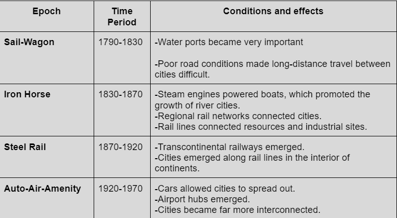
Concentric Zone Model
Model that shows a city as a series of rings that surrounds a CBD. Based on Chicago.
\-CBD
\-Transition Zone(industrial and low-cost and high density housing) (Manufacturing benefits from proximity to city-center, workers, and cheap land)
\-Low-cost(residential)
\-Moderate cost(residential)
\-Commuters’ Zone(residential)
\-CBD
\-Transition Zone(industrial and low-cost and high density housing) (Manufacturing benefits from proximity to city-center, workers, and cheap land)
\-Low-cost(residential)
\-Moderate cost(residential)
\-Commuters’ Zone(residential)
71
New cards
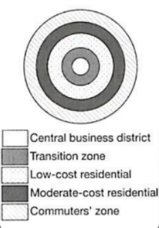
Sector Model
Model w/ rings growing outward from CBD over time. 1930s, Homer Hoyt. Describes sectors of land use for low(next to industrial and transport), medium, and high(higher ground) income housing and one for transportation extending from city’s center to the edge.
72
New cards
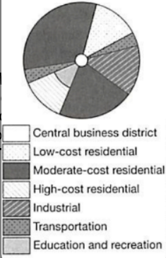
Multiple Nuclei Model
Based on changes in cities in 1940s. Suggested that functional zonation occurred around multiple centers/nodes. Each node: attracted/repelled certain types of activities.
This = patchwork of land uses, each w/ own center.
CBD and related functions existed but were joined by smaller business districts that emerged in the suburbs.
This = patchwork of land uses, each w/ own center.
CBD and related functions existed but were joined by smaller business districts that emerged in the suburbs.
73
New cards
Peripheral Model
Variant of multiple-nuclei model, describes suburban neighborhoods surrounding an inner city and served by nodes of commercial activity along a ring road or beltway.
Name→ role of service nodes w/ related suburbs that develop on periphery of original city.
Name→ role of service nodes w/ related suburbs that develop on periphery of original city.
74
New cards
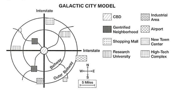
Galactic City Model
Based on Detroit w/ suburbanization ↑ gov. subsidies and highways. An original CBD became surrounded by a system of smaller nodes that mimicked its function. As suburbs grew, they took on some CBD functions.
@ key locations on transport routes— mini downtowns formed→ some big enough to become edge cities→ but this leaves a declining inner city
@ key locations on transport routes— mini downtowns formed→ some big enough to become edge cities→ but this leaves a declining inner city
75
New cards
European Cities characteristics
Try to preserve historic urban cores, so city leaders limit new construction and restrict height of buildings. Former palace grounds— now large urban parks. And CBDs have more residents in lower-rise apartments. Very walkable lifestyle from more living downtown which leads to more small businesses.
Suburbs = more likely to have tall buildings. Most are apartments. Suburbs→ see diversity from international immigration.
Suburbs = more likely to have tall buildings. Most are apartments. Suburbs→ see diversity from international immigration.
76
New cards
Middle Eastern/Islamic cities characteristics
Principal mosque in center of city, usually surrounded by complex of structures to serve the public(schools, soup kitchens). Major roads connect gates of the citadel(fort designed to protect city) to city center. Along the roads are suqs(traditional outdoor markets/covered bazaars).
Luxury items = closer to center
Bulky and less valuable = near wall/gate
-Streets and alleys usually twisting w/ dead-ends
-Homes have central courtyard rather than yards in front/back
-Windows are small and above eye-level
These = making shady areas so = cultural adaptation to sun. Also, privacy is important.
77
New cards
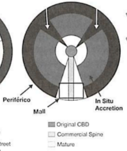
Griffin-Ford Model(Latin America)
Two part CBD at city center(traditional market and modern high-rise). Most desirable housing is near developed center of city. High quality housing extends outwards from urban core, accompanied by a commercial spine of development. The spine ends in a growing secondary center(called a mall).
Unlike concentric zone model— quality of housing goes down as distance from city center increases.
Unlike concentric zone model— quality of housing goes down as distance from city center increases.
78
New cards
Barrios/Favelas/Shantytowns
1 and 2 = neighborhoods marked by extreme poverty, homelessness, and lawlessness.
3 = poverty, lack of infrastructure, and areas of poorly built housing. Residents are often recent migrants to city.
\
Most 2→ most in disamenity zones(areas not connected to city services and under the control of criminals). Often physically unsafe(ex. steep, unstable mountain slopes). Poorly constructive structures, often by residents, and densely packed.
79
New cards
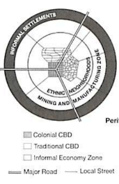
Characteristics of African Cities
Recent decades, urban areas have rapidly grown.
-Traditional CBD. Before European colonization, w/ small shops clustered along narrow, twisting streets. It includes the formal economy—permanent stores w/ full-time jobs that comply w/ local regulations and have set wages.
-Colonial CBD. Broad, straight avenues and large homes, parks, and administrative centers.
-Informal economy zone. Thrives w/ curbside, car-side, and stall-based businesses that often hire temporarily and do not follow all regulations. Also includes periodic markets, where small-scale merchants congregate weekly/yearly to sell goods.
-Zone of mining and manufacturing often found in cities
-Residential zones are often based on ethnicity. Mirror the multi-ethnic make-up of the continent’s countries.
\-Periphery of cities often has squatter settlements.
80
New cards
Squatter Settlements
Densely populated informal settlements. Often lack sufficient public services for electricity, water, and sewage. One of largest = Kibera, on western edge of Nairobi, Kenya.
81
New cards
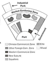
Characteristics of Southeast Asian Cities
Fits into McGee model. Focus of modern city is former colonial port zone. Export-oriented zone commercial uses like the CBDs of North American cities.
Might include gov. zone too. If capital—maybe commercial zone dominated by foreign merchants and ambassadors.
Belt of market gardening often surrounds and supplies cities.
History(centuries) of Chinese immigration and commercial interest. This immigration = secondary commercial zone dominated by Chinese.
82
New cards
Zoning Ordinances
(To balance competing desires) Regulations that define how property in specific geographic regions may be used. 3 general zoning categories:
\-Residential(where people live)
\-Commercial(where people and businesses sell goods and services)
\-Industrial(where businesses make things)
\-Residential(where people live)
\-Commercial(where people and businesses sell goods and services)
\-Industrial(where businesses make things)
83
New cards
Urban Planning
Process of promoting growth and controlling change in land use. Gov. uses zoning ordinances as a tool of this. Can = clear land-use segregation.
84
New cards
Residential Density Gradient
As one moves farther from the inner city, population and housing-unit density declines and types of housing changes.
85
New cards
McMansion
Type of homes from when homeowners in the suburbs tear down a home in a homogenous neighborhood and rebuild into this w/ a different style.
86
New cards
Filtering
When houses pass from one social group to another. Could change the use(single family to apartment). Most noticeable when ethnic enclave neighborhood changes to new group. Usually when less wealthy moves in after more wealthy. Ripple effect down social scale.
Important result of it = changing landscape by sequent occupancy.
Important result of it = changing landscape by sequent occupancy.
87
New cards
Invasion and succession
Refers to the process by which one social or ethnic group gradually replaces another through filtering.
88
New cards
Urban infill
Process of increasing residential density of an area by replacing open space and vacant housing w/ residences. One way to reduce urban sprawl on outer edges of the city in suburbs. Commonly used today.
89
New cards
Big-box retail stores
Definition from online: Stores that sell things in bulk so they are cheaper per unit, ex big department stores. (Economies of scale?) Have been successful as number and size of businesses in suburbs increase.
90
New cards
Suburbanization of businesses
Movement of commerce to the suburbs where rent is cheaper and commute for employees is shorter. Result→ many cities see decline in job opportunities, consumer choices, and services.
91
New cards
The difference in residential land use outside vs. inside the US
Outside North America→ residential density gradient usually not from higher to lower the farther one goes from CBD. Pop density ↑ in suburbs despite more land.
Gated communities = more common in Latin America as region develops. Popular w/ wealthy urban elite and so security-minded neighborhoods are emerging in residential areas in everywhere.
Gated communities = more common in Latin America as region develops. Popular w/ wealthy urban elite and so security-minded neighborhoods are emerging in residential areas in everywhere.
92
New cards
Infrastructure of a city
Facilities and systems that serve the population.
-Transportation(roads, bridges, parking lots, signs)
-Communications(cell phone towers, tv cables, internet service)
-Distribution(water, gas, electricity)
-Buildings(police stations, courthouses, fire stations)
-Collection(sewage, garbage)
-Entertainment(museums, theaters, and sports facilities)
-Open spaces(public parks and town squares)
Old cities: tend to be in poor condition.
93
New cards
Municipal(ity)
Refers to local gov. of a city/town and the services it provides. Gov. responsible for local infrastructure management while fed. gov. responsible for subsidizing large expenses.
Term w/ parenthesis: refers to a local entity that is all under the same jurisdiction.
Term w/ parenthesis: refers to a local entity that is all under the same jurisdiction.
94
New cards
Annexation
Process of adding land to a city’s legally defined territory.
95
New cards
Incorporation
Act of legally joining together to form a new city(when residents living beyond legal boundaries of the city don’t want to be a part of the central city).
1 potential reason: representation more local.
Many are only cities in legal and political considerations.
1 potential reason: representation more local.
Many are only cities in legal and political considerations.
96
New cards
Bedroom communities
Commuter suburbs
97
New cards
Unincorporated areas
Populated regions that don’t fall within legal boundary of any city/municipality. Legal boundaries of city on political map. Usually→ nearby municipality gives services and administration through higher division of civil gov.
Over time, residents may consider annexation/incorporation.
Over time, residents may consider annexation/incorporation.
98
New cards
How does infrastructure vary in countries? Economics? Social?
Economics: Can serve over 100 countries w/ around 1,800 trains moving people around the city per day(Frankfurt), or be an obstacle due to extensive unplanned pop. growth.
Valuable real estate used for parking areas and costs associated w/ car ownership.
Social: Can improve living conditions(sanitation by indoor plumbing).
Congested roads and long commute times.
Valuable real estate used for parking areas and costs associated w/ car ownership.
Social: Can improve living conditions(sanitation by indoor plumbing).
Congested roads and long commute times.
99
New cards
Public Transportation
Buses, subway, light rail, and trains that are operated by a gov. agency.
100
New cards
Impact of the car in urban areas
Data about car use can be used to improve traffic flow. Use of this data by cities = example of applied geography.
Cameras can let cities adjust traffic flows as a response to accidents and weather in real time.
Cameras can let cities adjust traffic flows as a response to accidents and weather in real time.