EBF Temperate Streams and Lakes
1/25
There's no tags or description
Looks like no tags are added yet.
Name | Mastery | Learn | Test | Matching | Spaced | Call with Kai |
|---|
No analytics yet
Send a link to your students to track their progress
26 Terms
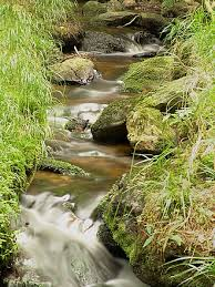
lotic system
flowing water down a gradient
stream, river, creek
lentic system
still or near still flow
lakes and ponds
physical characteristics of streams
chemistry
temperature
gradient
stream size
all dependent on geography and geology


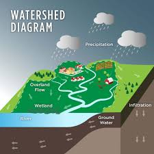
watershed
topographic area of land draining to a single point via surface or groundwater flow
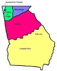
5 ecoregions of Georgia
Appalachian plateau
valley and ridge
blue ridge
piedmont
coastal plain
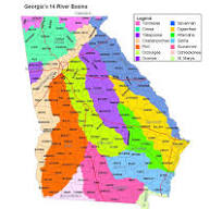
14 Georgia river basins
the Altamaha, the Chattahoochee, the Coosa, the Flint, the Ochlockonee, the Ocmulgee, the Oconee, the Ogeechee, the Satilla, the Savannah, the St. Mary’s, the Suwannee, the Tallapoosa and the Tennessee
cold water
temperature rarely exceeds 24 degrees Celsius (75 degrees Fahrenheit) for extended periods of time
warm water
a freshwater system that seasonally exceeds 24 degrees Celsius (75 degrees Fahrenheit)
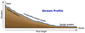
gradient
the slope or steepness of a stream channel, measured as the vertical drop in elevation over a horizontal distance (rise over run)
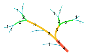
Strahler stream order
a top-down dendritic classification of river systems to identify a hierarchy of tributaries within the system
1st order + 1st order = 2nd order
2nd order + 2nd order = 3rd order, etc.
river continuum concept
model for classifying and describing riverine ecosystems,
a river is dependent on upstream inputs
biotic complexity changes as the river gets larger
increased diversity and primary productivity as a system moves downstream and grows in size
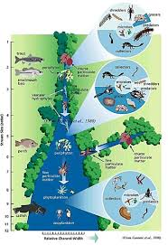
headwater streams
higher input from terrestrial environment
lower fish diversity
high insectivory
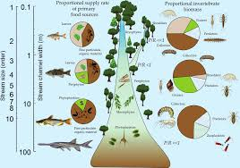
mainstem large river
higher primary productivity
higher fish diversity
higher piscivory

pool
areas of slow flowing, deep water, often on the outside of the bends
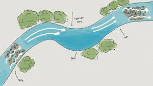
runs
smooth unbroken flow, connecting riffles and pools

riffles
fast, shallow flow, over boulders and cobbles, which break the water surface

resource partitioning
differential use of resources in time and space to minimize overlap in niches
spawning partitioning
forage partitioning
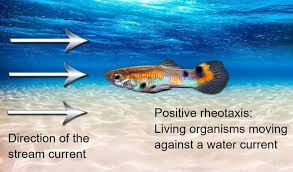
rheotaxis
orientation into stream current
positive = orients body into oncoming current
negative = orients away from oncoming current
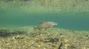
drift feeding
strategy where fish face upstream to catch prey items carried by the current
interspecific and intraspecific competition
aggression use to maintain position in water
threats to temperate streams
point and non-point source pollution
changes chemistry and water quality
alters communities
connectivity
dams, culverts limit fish passage
alter flow and sediment transport
global climate change and stream temperature
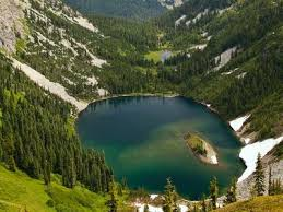
lake
natural basin of freshwater surrounded by land, not connected directly to the ocean


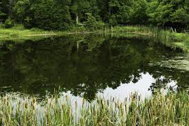
pond
smaller lake

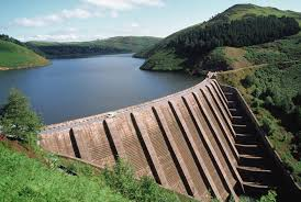
reservoir
a man-made basin of freshwater typically created by impounding a lotic system
physical characteristics of lakes
light
temperature
water movement and stratification
chemistry
lake size
primary producers in lakes
microscopic algae
macroscopic algae (mostly green)
true plants (floating, emergent, submerged)