Section C: Physical Landscapes in the UK
1/61
Earn XP
Description and Tags
all from megabook
Name | Mastery | Learn | Test | Matching | Spaced | Call with Kai |
|---|
No analytics yet
Send a link to your students to track their progress
62 Terms
1.1 Can you name the longest river in the UK?
River Severn is 220 miles long
1.2: What is an upland area of Scotland and what is an upland area of England?
Scotland - Grampian Mountains
England - The Pennines. Or the “backbone of Britain”
1.3: Can you name the highest mountains in the UK and in England?
UK: Ben Nevis in Scotland. Summit 1,344m above sea level
England: Scafell Pike in Lake District. Summit 978m above sea level
2.1: What makes waves form?
Waves are formed by wind blowing over sea surface
2.2: What is the ‘fetch’ of a wave?
Distance over which waves form
Longer = bigger and more powerful waves
e.g waves crashing onto SW of British Isles have a fetch over 3,000 miles across the Atlantic Ocean
2.3: What is the swash and the backwash of a wave?
Swash: wave running up the beach
Backwash: wave returning back down the beach
2.4: What are the characteristics of constructive waves?
Strong swash, weak backwash
'Spill' up the beach
Long in relation to height (lower, less steep waves)
Longer wave length (distance between wave crests)
Longer gaps, breaking rate of 6-8/min
Formed by distant storms, hundreds of km away
Push sand and pebbles up the beach and leave them there = flat, gentle beach
2.4: What are the characteristics of destructive waves?
Weak swash, strong backwash
Plunge down on the beach
High in proportion to length (steep, high waves)
Shorter wave length (distance between wave crests)
Shorter gaps, breaking rate of 15/min
Formed by local storms with high winds close to the coast
Cause beach erosion, pull sand and pebbles from beach = steep
3.1: What is coastal weathering?
breaking down of rocks caused by weather factors (rainfall and changes in temp)
sub-aerial process (under the sky), rather than marine process (caused by sea)
3.2: Can you explain ‘freeze thaw’ weathering at the coast?
Mechanical weathering:
Freeze-thaw = rain freezes at night in rock cracks, and expands
Repeats many times, breaking up the rock
3.3: Can you explain chemical weathering at the coast?
Chemical/solution weathering includes carbonation:
Rain absorbs C02 from air and becomes slightly acidic
Contact with alkaline rocks (chalk, limestone) makes chemical reaction = rocks slowly dissolve
Chalk cliffs are susceptible
3.4: What is coastal mass movement and can you give two examples?
Rock loosened by weathering from above and marine erosion from sea moves downward under gravity, often along a curved surface
e.g include sliding, slumping or rock fall
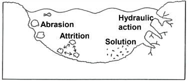
4.1: Can you explain ‘hydraulic power’, ‘abrasion’ and ‘attrition’ coastal erosion?
Hydraulic power/action: Water forced into tiny air pockets in cliff cracks, compressing air inside = mini explosions that force rock apart
Abrasion: Loose rock (sediment) is thrown at cliffs, scraping and wearing them away like sandpaper
Attrition: Loose sediment on sea bed knocked around into smaller and rounder particles
4.2: Can you explain the formation of: headlands and bays?
Coasts are formed from alternating bands of hard and soft rocks
Bays: Erosion process (abrasion) erodes soft rock (clay) faster than hard (chalk)
Headlands: More resistant harder rock sticks out to sea
4.2: Can you explain the formation of: Wave-cut platforms and cliffs?
They both form where there’s hard rock (chalk, limestone):
Erosion processes (abrasion) erode cliffs over time between high and low tide marks
Notch, then an overhang develops, which over time collapses
Process repeats and cliff-face retreats = wave-cut platform
4.2: Can you explain the formation of: Cave, arch, stack and stump?
Erosion processes (hydraulic action) at headlands make and widen natural faults in rock = cracks, and then caves
Over time cave erodes to form arch
Arch collapses = stack, fall down = stump
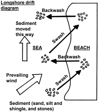
4.3: Definition of longshore drift
The movement of beach material along a coast
4.3: Can you draw a labelled diagram to explain longshore drift?
Prevailing wind forces swash to move up the beach, at an angle transporting sediment, while backwash goes back down the beach at 90 under gravity
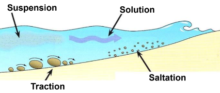
4.3: Ways that sediment is moved along the coast diagram and definitions
Traction: Larger pebbles rolled along sea bed
Saltation: Small pebbles bounce along sea bed in a skipping motion, often 1 pebble hits another
Suspension: Fine sediment carried along the water = looks murky
Solution: Dissolved material carried along in solution = can't see it
4.4: What is the meaning of coastal deposition, and what is a beach and how do they form?
Deposition - When sea puts down the sediment it’s carrying.
Beach - area of deposited sand, shingle or pebbles
Formed by deposition in sheltered bays between 2 headlands as there’s less wave energy = constructive waves dominate with strong swash that builds up a beach
4.5: What is a sand dune and how do they form?
Depositional landforms, formed by sand blown in from the beach
Dunes stabilise by vegetation (sea couch grass, marram grass)
Marram grass is adapted to windy, exposed conditions, with long roots to find water
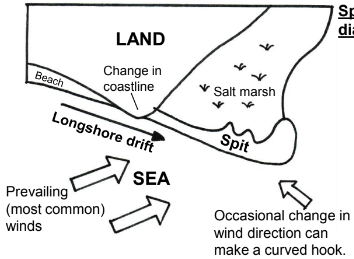
4.6: Can you explain the formation of a spit and a bar? What happens if theres a change of wind?
Spit - long, curved narrow ridge of sand and shingle connected to coast at 1 end. Often salt marsh behind
Formed when longshore drift moves sediment along coastline in same direction as prevailing wind. Sediment is deposited when coastline suddenly changes direction e.g where coastline meets a river mouth.
Bar - spit of sand and shingle that extends the whole way across a bay
4.7: CASE STUDY of a section of UK coastline: What major landforms of erosion can be found along this coastline?
Hengistbury Head - headland in Dorset, south coast of England. Juts out into the English Channel.
Landforms - cliffs eroded into sand, gravel and clay geology. Geology is soft compared to chalk cliffs near Swanage.
Cliffs formed by coastal erosion processes (abrasion) where sediment in sea (sand and rock) is thrown against coastline = wears it away
4.7: CASE STUDY - Are cliffs at Hengistbury Head affected by mass movement?
Mass movement - big amount of cliff material moves downhill in landslide
Yes - marine erosion (abrasion) erodes cliff bases = landslides like slumping ones that are worsened by rain
Rain infiltrates into sandy upper layers of the cliffs, and meets impermeable clay = cliffs get very heavy and slump downwards
4.7: CASE STUDY of a section of UK coastline: What major landforms of deposition can be found along this coastline?
Mudeford spit - sand carried E - NE by longshore drift, deposited at end of HH, across Christchurch Harbour
MS has sand dunes, as sand carried up the beach by wind collects into mounds
Formation is aided by marram grass: salt water-tolerant plant that helps stability and growth
Large beach in front of HH. Sand is put down by sea to make a beach 2km+ long, 100m wide, depending on tide
formation is assisted by human intervention, "Long Groyne" traps a lot of sand being carried E by longshore drift
4.7 CASE STUDY of a section of UK coastline: Hengistbury Head to Swanage, Dorset. Another headland, not HH, and it’s landforms
13km west of HH is headland “Foreland”. Also in county of Dorset, flanked by 2 bays - Swanage and Studland
It’s a discordant coastline = alternating bands of more (harder, chalk, limestone) and less resistant (softer, sand, clay) rocks = headlands and bays
Landforms of erosion = Old Harry, famous stack of chalk off the edge of Foreland between the 2 bays + Old Harry's Wife, stump which was a stack till storm collapsed it in 1896
Landforms of deposition = 2 popular beaches lying in Studland and Swanage Bay
4.7 - Whats a concordant coastline?
The same type of rock along its length, with fewer bays and headlands
5.1: What is hard and soft coastal engineering?
Hard engineering = expensive man-made defence using concrete, rocks or wood to controlling erosion. Less sustainable or environmentally friendly approach, but effective for many years
Soft engineering = sustainable and less expensive way to manage erosion, using natural methods
5.2: Can you evaluate (give pros and cons) examples of hard engineering?
Sea wall
Pros: Strong concrete barrier against erosion. Promenade for tourists. Curved to deflect waves
Cons: Min £5,000/m, unattractive coast. Base are undercut 'basal scouring'
Groyne
Pros: Trap sand carried by longshore drift, to build large protective beach
Cons: ‘Starve' sand from other places along the coast, £10,000
Rock armour
Pros: Large boulders reduce wave power. Cheaper than sea wall
Cons: £1000/m, stops people getting in the sea
5.2: Can you evaluate (give pros and cons) examples of soft engineering?
Beach nourishment:
Pros: Artificially adding sand to beach looks natural, absorbs wave power and attracts holiday-makers. Cheap, £10/cubic metre
Cons: Repeated every year
Sand dune regeneration:
Pros: natural erosion barrier. Encouraged/created by stopping trampling and instead, planting salt water-tolerant marram grass
Cons: Not as effective as sea wall
5.3: What is managed retreat / coastal realignment?
Letting coast erode in a natural way, not building new defences or replacing old ones
Some will lose land and property
Gov might pay compensation to people forced to move
5.4: CASE STUDY. Why does HH have coastal management?
Coastal erosion is a threat to it as it’s a
Scheduled Ancient Monument due to human history (activity for 12k+ years) and archaeology
Site of Special Scientific Interest (SSSI)
Local Nature Reserve (LNR)
habitat has rare and endangered plant, bird and insect species.
Tourism - mill+ visitors each year, 2 popular beaches, in front of HH and MS
MS is known for colourful beach huts, expensive to buy or rent
HH protects Christchurch Harbour
5.4: What management strategies are used?
Long Groyne at the end HH builds up protective sediment to reduce erosion
15 extra groynes are maintained along MS
100m of rock armour
5.4: What are the future plans for the Long Groyne?
Closed to public for safety, 2019. Regularly submerged under water + inspection showed 80year-old had very poor condition
Crucial to build up protective sediment in front of HH. Without it, beach material would rapidly wash away, cliffs start to erode in a year
It increases sediment deposition to protect large settlements nearby (Bournemouth), part of "hold the line" coastal management policy
Next 10yrs, BCP Council (Bournemouth, Christchurch, Poole) will receive £33 mill of gov funding to protect coastline
Long Groyne will be repaired, upgraded, and raised in height to provide protection for the next 100yrs from predicted sea-level rise
5.4: What conflicts does the management strategy cause?
Groynes at HH and MS cause sediment starvation further E along coast
5km to E, severe erosion problem at Barton on Sea - led to hard engineering strategy being built to protect village of 7,000
6.1: What is meant by these river words? Source, mouth, tributary, confluence, drainage basin, watershed.
Source: river starts, many metres above sea level
Mouth: where river flows into the sea
Tributary: smaller river that joins the main channel.
Confluence: where a tributary joins the main river channel
Drainage basin: area of land drained by a system of rivers.
Watershed: high-point that separates one drainage basin from the next (an imaginary line)
6.2: What is the long profile and how does it change over the course of a river?
Long profile is the cross-section from a river's source to its mouth
River gradient (steepness) decreases downstream: steep in upper to more gentle in lower course
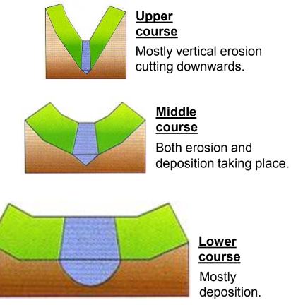
6.3: What is the cross profile and how does it change over the course of a river?
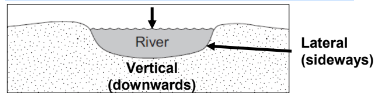
Cross profile is the cross-section across a river's channel and valley
Upper course - valley is narrow and steep sided in a V- shape. Channel is small and fairly shallow. River erodes vertically.
Middle course - valley is wider with more gently sloping sides. Channel is wider and deeper. River erodes vertically and laterally. Flood plain begins
Lower course - Valley is very wide and flat with big flood plain. Channel is at its widest and deepest. River discharge and velocity are at their max. River erodes mostly laterally (sideways)
7.1: Can you explain the four types of river erosion?
Hydraulic action: Fast-flowing water forced into cracks, breaking up river banks over time.
Abrasion: Stones and pebbles dragged along river bed and banks, wearing them away.
Attrition: Rocks and stones wear each other away as they knock together.
Solution: Where rocks such as chalk and limestone are dissolved in slightly acidic rainwater.
7.2: What is vertical and lateral erosion?
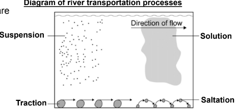
7.3: Can you explain the four types of river transportation?
Traction: Large stones rolled and dragged along
Saltation: Smaller stones or pebbles picked up and dropped again in a skipping motion
Suspension: Tiny particles of sediment carried suspended in the river's current
Solution: Where dissolved rocks are carried along invisible to the eye
7.4: Why do rivers deposit sediment?
deposit sediment (river load) where they have reduced energy to transport material.
e.g deposition happens on inside bend of a meander where the river flow is slower than the outside bend OR on a river's flood plain in times of flood
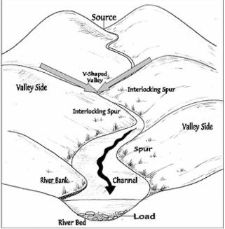
8.1: Can you explain the formation of interlocking spurs?
A river erodes vertically into the land in its upper course
Sides of the channel eventually collapse into river
Over time, V-shape forms in landscape. River weaves through 'fingers' of land that jut out, called interlocking spurs
River is near its source, and so is not powerful enough to cut through the spurs of land, so has to flow around them
8.2: Can you explain the formation of a waterfall and a gorge, and draw labelled diagrams to show this?
river is flowing over harder rock. Meets some less resistant rock
softer rock erodes faster. Erosion processes (hydraulic action and abrasion) create a hollow known as a plunge pool.
Above, the harder rock overhangs as a ledge, that eventually collapses into the plunge pool
Erosion continues, so over time waterfall retreats upstream, carving out a gorge.
8.3: Can you explain the formation of meanders and oxbow lakes, and draw labelled diagrams to show this?
A river is flowing across the landscape
Erosion takes place on outside of the bends. Deposition takes place on inside of the bends
Continued erosion and deposition = bends are bigger over time, form looping meanders
Sometimes the inside bends get so close, the river cuts straight across, leaving an oxbow lake.
8.3: Extra: Can you explain the shape of a meander cross- section and draw a diagram of this?
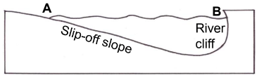
river flow is faster on outside of a meander = more erosion to make the river deeper here and form a “river cliff”
Inner side has slower flow = deposition and a 'slip-off slope'
Meanders have an uneven asymmetrical cross-section
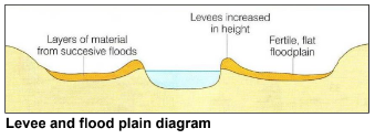
8.4: Can you explain the formation of levees, flood plains and estuaries?
Levee - natural mound of material on the banks of a river. Form as river load material is deposited during flood OR man-made from concrete as a flood defence
Flood plain - Layers of deposited river load material build up. Larger material is deposited next to channel as river's energy is lost. Smaller is carried further
Estuary - river mouth affected by tides as it reaches sea. Lot of sediment deposited at the end of a river's journey, which is exposed at low tide
8.5: CASE STUDY of a river valley in the UK: Name, length, location
River Severn is 220 miles long. Source is 600m above sea level in Plynlimon Hills, central Wales
Flows through several counties; Shropshire, Worcestershire and Gloucestershire
Mouth is at the end of Bristol Channel, where River Severn discharges into Atlantic Ocean
8.5: CASE STUDY of a river valley in the UK: What are its major landforms of erosion?
Upper course: Near source, it flows through a V-shaped valley
First major waterfall is 'The Severn Breaks Its Neck' which has a 4m drop
8.5: CASE STUDY of a river valley in the UK: What are its major landforms of erosion AND deposition?
Middle course: A famous meander is 'Roundabout', 5km north-east of Welshpool (town in Wales). It has steep river cliffs and slip-off slopes
8.5: CASE STUDY of a river valley in the UK: What are its major landforms of deposition?
River Severn ends at Severn Estuary, up to 13km wide and crossed by 2 road bridges, with a tidal range of 15m.
Estuaries are transitional zones between river and coastal environments and are affected by wave action and river processes
Main is deposition, where river sediment is put down. Over time, mudflats develop into important natural habitats called salt marshes
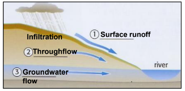
9.1: What is river discharge? 9.2: What is surface runoff, throughflow and groundwater flow?
River discharge: Amount of water passing a point in a river, measured in cubic metres per second (cumecs).
Surface runoff: Rain flowing to river over land, fastest way it can get to a river
Throughflow: water flows through the soil
Groundwater flow: groundwater flowing to river, slowest movement of the 3
9.3: How can physical factors affect flood risk? Precipitation, geology and relief.
Precipitation: Prolonged heavy rainfall, associated with a "depression" = greater flood risk
Geology (rock type):
Impermeable rocks (clay) don't allow infiltration = greater flood risk.
Permeable rocks and soils (sandy) absorb water easily = less flood risk
Porous rocks (chalk) have spaces between rock particles = absorbing of water and less flood risk
Relief: Steeper slopes = more surface runoff = more flood risk
9.4: How can human factors affect flood risk?
Building impermeable surfaces (concrete) and deforestation = increase surface runoff speed and flood risk
Planting trees (afforestation) reduces flood risk as trees take up water in their roots, and leaves intercept rainfall.
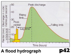
9.5: What is a flood hydrograph and what is lag time?
Graph showing how river responds to particular storm
Lag time - time between peak rainfall and peak river discharge, depends on physical factors above.
'flashy' river hydrograph - shows quick lag time between peak rain and peak discharge
10.1: What is river flood hard engineering?
Building structures to protect people and property from flood water, or artificially changing river course to reduce its likelihood to flood
10.1: Can you evaluate examples of river flood hard engineering?
Dams and reservoirs: + Trap and store water. - Expensive and block rivers, look unnatural.
Storage areas: + Place for excess water to run off to. - Land can't be used for other uses like housing.
Flood levees: + Raise banks of the river to hold more water. - Unattractive concrete.
River straightening and deepening: + Speeds up river flow to sea and allows river to carry more water - May increase flood risk downstream.
10.2: What is river flood soft engineering?
Trying to manage flood risk in a more environmentally friendly and sustainable way
10.1: Can you evaluate examples of river flood soft engineering?
Flood plain zoning = Build more important land uses above flood levels. + Houses and hospitals protected - Flood plains can't be developed
Flood predictions and warnings: UK Environment Agency has 3 levels. + People look up online flood info for any post code (flood alert, flood warning and severe flooding warning). - Doesn’t stop flooding.
Planting trees (afforestation). + more rain interception and less surface runoff
10.3: CASE STUDY of a flood management scheme in the UK: Boscastle, Cornwall. Why the scheme was required?
August 16, 2004, small village Boscastle hit by thunderstorm, unleashed flash flood of rare intensity in UK
18cm rain fell 11:30am-4:40pm. Exceptional water amount. Rained down steep valley slopes into Valency and Jordan rivers that meet in Boscastle.
Wall of water surged through streets, rising to height of 3m. Cars carried along, acting like battering rams.
10.3: CASE STUDY of a flood management scheme in the UK: Boscastle, Cornwall. The management strategy
Hard engineering:
river wall built along Valency = higher discharge before overflowing.
Car park has raised to act as a flood defence, using concrete. Has a 'soft' aspect - permeable surface = more rain to infiltrate
Soft engineering:
Better tree management in Valency valley = trees are planted and looked after to absorb rain and slow surface runoff from area's steep relief
Shape of Valency's channel changed = wider and lower to increase water capacity. Although uses diggers and concrete, soft approach as river looks natural
10.3: CASE STUDY of a flood management scheme in the UK: Boscastle, Cornwall. Issues
Social issues
Reduced flood risk for locals. Flood risk was 1 in 10 years, now 1 in 75
Economic issues
flood management scheme cost £10 mill. Paid for by Environment Agency=UK tax payer
Some local traders were angry about lost business during flood defence works
Environmental issues
flood management scheme uses combination of hard and soft approaches