Unit 1: Thinking Geographically - AP Outline
1/38
Earn XP
Description and Tags
Name | Mastery | Learn | Test | Matching | Spaced | Call with Kai |
|---|
No analytics yet
Send a link to your students to track their progress
39 Terms
Absolute Direction
Corresponds to the direction on a compass: north, south, east, west, and combinations such as northeast and southwest
Ex - Milwaukee is NORTH of Chicago

Absolute Distance
Exact, measurable physical space between two locations, usually expressed in units like miles or kilometers
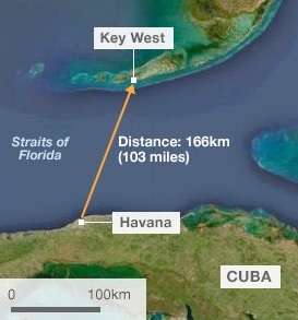
Ex - Cuba is 100 miles from Florida
Absolute Location
The precise, fixed position of a place on Earth, typically expressed using latitude and longitude coordinates
Ex - Chicago is 41.8781° N, 87.6298° W
Census Data
Comprehensive collection of demographic and economic information about the population of a region, conducted by a government agency

Cultural Landscape
Built forms that cultural groups create inhabiting Earth and the meaning, values, representations, and experiences associated with those forms
Geographical area shaped by human activity and reflecting cultural practices, beliefs, and values
Elevation
Height of a location or feature above or below mean sea level
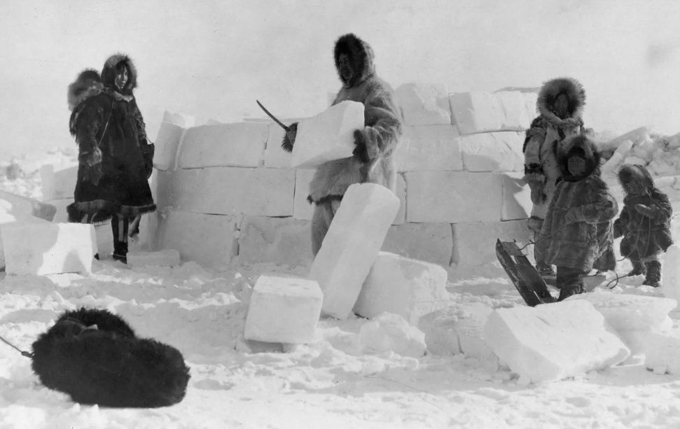
Environmental Determinism
Belief that a region's physical environment, including climate, landforms, and natural resources, determines the development and cultural patterns of the people who live there
Ex - Development of Inuit culture in response to the Arctic conditions in which they live
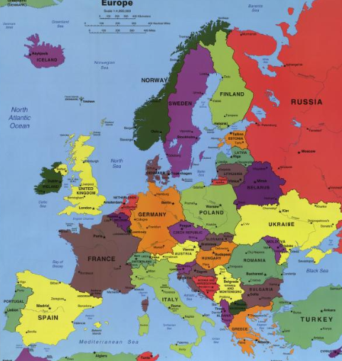
Formal Region
Area that shares one or more common characteristics, such as language, climate, or economic activity, throughout its boundaries
Ex - Cultural or political boundary
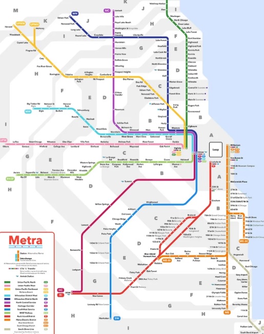
Functional Region
A geographic area that has been organized to function politically, socially, culturally, or economically as one unit
Area organized by its function around a focal point (node), or the center of an interest or activity
Ex - businesses or transportation hub
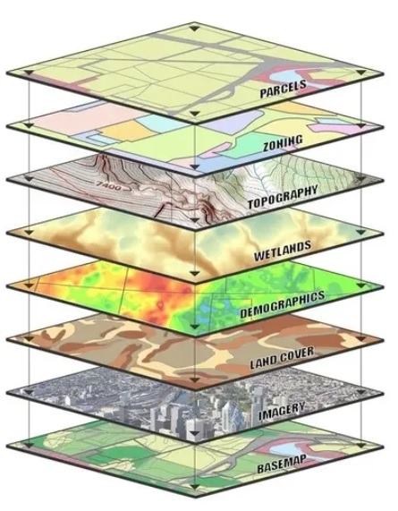
Geographic Information System (GIS)
Computer-based system that captures, stores, analyzes, and displays geographically referenced data used for mapping and spatial analysis
Information stored in “thematic layers”
Global Positioning System (GPS)
Satellite-based navigation system that provides precise location and time information anywhere on Earth
Network of satellites to transmit signals to GPS receivers, allowing for the accurate determination of geographical coordinates
Natural Resources
Something found within the natural environment that is accessible and economically valuable to humans including food, water, soil, plants, animals, and minerals
Perceptual/Vernacular region
Geographic area defined by people's beliefs, feelings, and attitudes about a place, rather than by physical or official boundaries and often shaped by cultural identity and experiences
Place
A location on Earth that is distinguished by its physical and human characteristics
Possibilism
The belief that any physical environment offers a number of possible ways for a society to develop and that humans can find ways to overcome environmental challenges
Reference map
Map that shows the location of geographic features and political boundaries
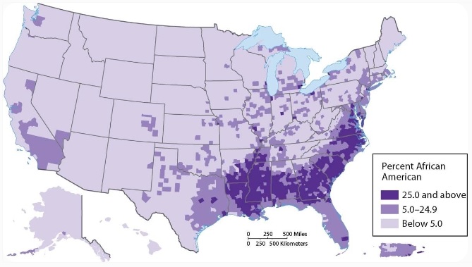
Region
Geographical area defined by shared characteristics, which can be physical, human, or both
Relative Direction
A direction that can be described as position, such as in front of or behind, to the left or to the right; describes the general relationship between places
Relative Distance
A measurement of the level of social, cultural, or economic similarity between places despite their absolute distance from each other
Approximate measurement of the physical space between two places, considering factors like time, cost, and difficulty of travel
Relative Location
Describes a place's position in relation to other places, landmarks, or geographical features
Remote Sensing
Process of collecting information about the Earth's surface from a distance, typically using satellites, aircraft, or drones
Satellite Imagery
Images of Earth taken by artificial satellites orbiting the planet
Scale
Refers to both the relationship between Earth's surface and the portion being studied, and the different scales of analysis), which are hierarchical levels of observation (global, national, regional, local)
Sense of Place
The emotional and psychological connection individuals have with specific locations, shaping their perceptions and experiences of those places
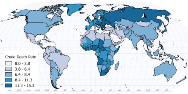
Thematic Map
Type of map that visually represents a specific subject or theme related to human activity and spatial patterns
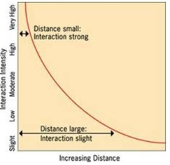
Distance Decay
Interactions between places weaken as the distance between them increases; things that are close to each other are more likely to be related or have interactions than things that are further apart. Essentially, the further you are from something, the less likely you are to interact with it.
Time-Space Compression
The shrinking of distance and time through advancements in technology, particularly in transportation and communication, leading to greater global interconnectedness and a feeling that the world is smaller
Flow
The movement and connections between places and people, including the flow of resources, information, ideas, and even cultural elements (SPEED)
Globalization
The increasing interconnectedness and interdependence of countries and cultures, primarily driven by advancements in technology, communication, transportation, and trade
Human Geography
The study of the processes that have shaped how humans understand, use, and alter Earth
Pattern
The observable arrangement or distribution of people, objects, or phenomena across space
Sustainability
The use of Earth's land and natural resources in ways that ensure they will continue to be available in the future; Development that meets the needs of the present without compromising the ability of future generations to meet their own needs
Scale of Analysis
The geographical area or level of organization used to study and analyze data:
Global: Encompasses the entire world and ignores borders of countries
Regional: Focuses on large geographic areas or regions (e.g., West Africa, North America)
National: Focuses on a single country (France, Japan, Botswana)
Local: Focuses on a specific location within a country (e.g., a city, state, province).
Clustering
Spatial pattern where people or objects are closely grouped together in specific areas of a population. This suggests that the concentrated regions have a higher density than the surrounding areas
Dispersal
Spatial pattern where objects are spread out from one another
The way in which a phenomenon, like a population or cultural trait, is spread out over a geographic area
Map Distortion
Inaccuracies that occur when representing the Earth's three-dimensional surface on a two-dimensional map; distorts spatial relationships in shape, area, distance, and direction
Online Mapping and Visualization
Using digital tools and techniques to create and display maps and geographic information online, often through Web Geographic Information Systems (Web GIS)
Spatial Relationships (Distribution)
Arrangement or spread of phenomena across space
Regional Analysis
The study of a specific area or region to understand its unique characteristics, patterns, and how its parts interact; examining physical, social, economic, and cultural factors to explain the region's functioning