Geospatial Unit 1
1/218
There's no tags or description
Looks like no tags are added yet.
Name | Mastery | Learn | Test | Matching | Spaced | Call with Kai |
|---|
No analytics yet
Send a link to your students to track their progress
219 Terms
Geospatial technology
describes the use of a number of different high-tech systems and tools that acquire, analyze, manage, store, or visualize various types of location-based data (geospatial data)
Geographic information system (GIS)
Computer-based mapping, analysis and retrieval of location-based data.
“what” and “where” questions.
• What is the mean annual precipitation in Maryland?
• Where is the highest/lowest precipitation in the U.S.?
Remote sensing
Acquisition of information (satellites, aircrafts, UAVs) about an object or phenomenon without making physical contact with the object.
Global positioning system (GPS)
Acquisition of real-time location information from a series of satellites in Earth’s orbit.
-first gps satellite launched in 1978
Satellite imagery
digital images of Earth acquired by sensors onboard orbiting spaceborne platforms

Aerial photography
acquisition of imagery of the ground taken from an airborne platform

GTCM (Geospatial Technology Competency Model)
a model set up by the U.S. Department of Labor to help define essential geospatial skills
GISP (GIS professional)
the title given for professional GIS certification
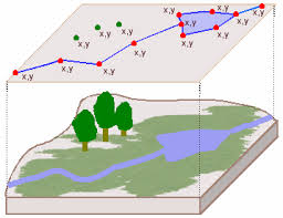
Geospatial data
(also often referred to as “spatial data”) refers to location-based data, which is at the heart of geospatial technology applications.
• When the data has a location that it can be tied to, it’s geospatial data (e.g., location, boundary, area, length, distance, volume, etc.)
___ combines:
• Location information: x, y coordinates
• Attribute information: characteristics of the object or phenomenon
• Temporal information: the time or life span at which the location and attributes exist (not always required)
Non-spatial data
refers to data that is not directly linked to a geospatial location.
• Attribute table (ID#, address, name, type, value, etc.)
• Metadata (“the data about your data”)
Examples:
-Population demographics
Includes age, income, education level, ethnicity, and employment status of people living in a geographic area.
Land use type
Describes how a parcel of land is used, such as residential, commercial, agricultural, or industrial.
Soil composition or pH level
Provides chemical and physical properties of soil in a region, which are critical for agriculture and environmental studies.
The national Map
an online basemap and data viewer with downloadable geospatial data maintained and operated by the USGS and part of the National Geospatial Program
VGI (volunteered geographic information)
a term used to describe user-generated geospatial content and data
wiki
a database available for everyone to utilize and edit
crowdsourcing
the activities of untrained volunteers to create content and resources that can be utilized by others
citizen science
the activities of untrained volunteers conducting science
Geolocation
the technique of determining where something is in the real world
Your smartphone, tablet, laptop, or desktop computers can determine your
current location by using the geolocation technique and then plot your
location on a digital map.
• IP address
• Wi-Fi connection
• Cell towers
• GPS receiver
W3C Geolocation API
a JavaScript programming technique that enables web applications to obtain user location information.
Geotag
a function to connect real-world location information to a media item (a tweet, photo, FB post, etc).
Google Earth
a freely available virtual globe program first released in 2005 by Google
virtual globe
a software program that provides an interactive three-dimensional map of Earth
KML (keyhole markup language)
the file format used for Google Earth data
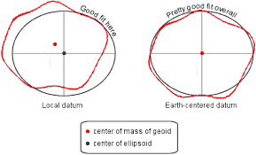
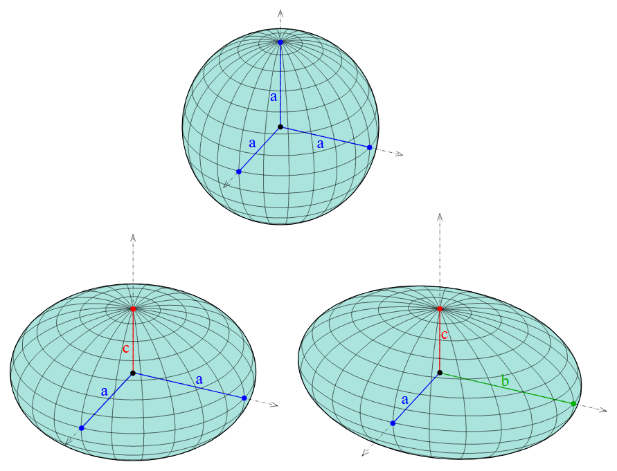
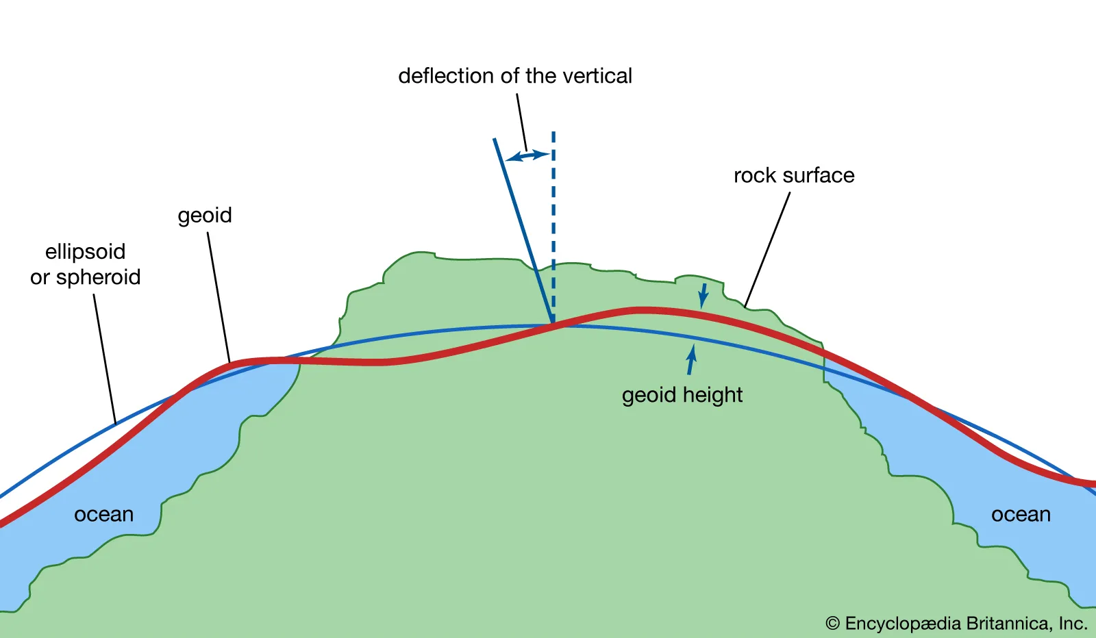
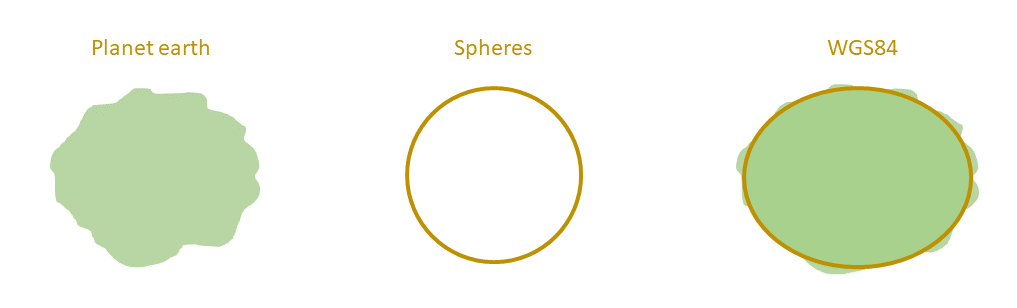
Datum
an ellipsoid model that approximates the shape of the Earth to enable accurate position, length, and area calculations
-the way we use the ellipsoid to try to fit the geoid
ellipsoid
a model of the rounded shape of Earth, which assumes Earth's surface is flat and smooth.
geoid
a model of Earth using mean sea level as a base
takes mountains and trenches into account as an Earth model
geodesy
the science of measuring Earth’s shape to develop these kinds of models and
reference surfaces
datum transformation
the process of changing measurements from one datum to measurements in another datum
When is it necessary?
—>Your map and data layers use different geographic coordinate systems → For example, your base map is in WGS84, but your shapefile is in NAD83.
—>You're aligning GPS data with survey benchmarks or topographic maps → GPS often uses WGS84, while local data might use NAD83 or a state-specific datum.
geographic coordinate system (GCS)
a set of global latitude and longitude measurements used as a reference system for finding locations
-based on an ellipsoid Earth model.
-A datum must be determined before using. Certain datums fit different parts of the Earth better than others. In order to make measurements more accurate, one has to decide which datum to use for different regions
-meridians run north to south & are used to measure locations east and west on Earth
-Both the equator & the prime meridian have a value of zero
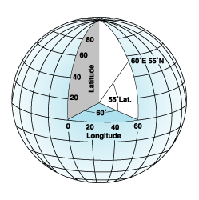
latitude
imaginary lines on a globe north and south of the Equator that serve as a basis of measurement in GCS
-Latitude lines run east-west and measure north-south positions
-Measures how far north or south a location is from the Equator (0° latitude).
Lines run horizontally.
Values range from 0° to 90° North or 0° to 90° South.
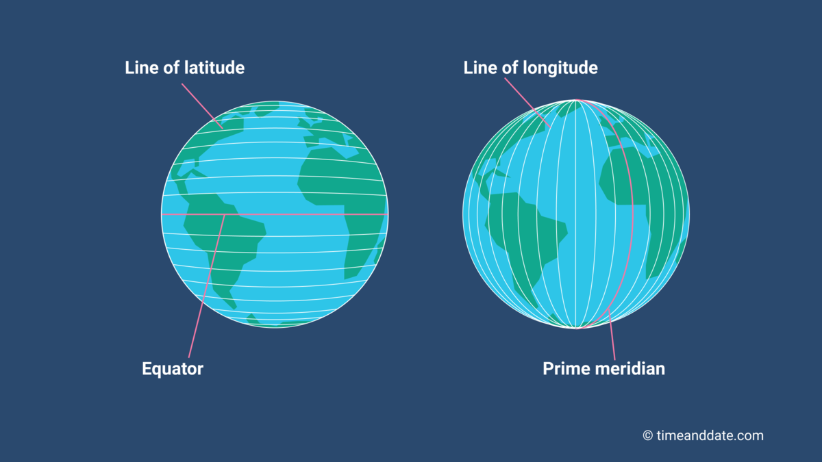
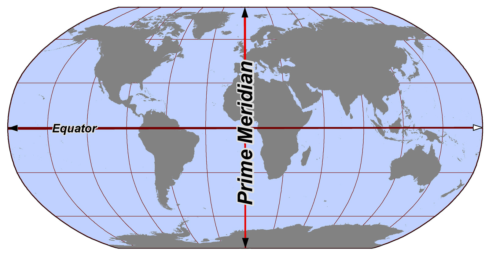
equator
the line of latitude that runs around the center of Earth and serves as the 0 degree line from which to make latitude measurements
longitude
imaginary lines on a globe east and west of the Prime Meridian (runs through Greenwich, England) that serve as a basis of measurement in GCS
Lines run vertically.
Values range from 0° to 180° East or 0° to 180° West.
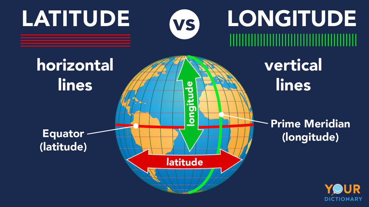
prime meridian
the line of longitude that runs through Greenwich, England, and serves as the 0 degree line of longitude from which to base measurements
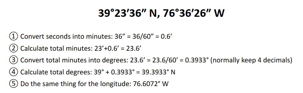
degrees, minutes, and seconds (DMS)
the measurement system used in a GCS
1 degree or 1° = 60 minutes or 60’
1’ = 60 seconds or 60”
Format:
39°23'36" N, 76°36'26" WBreakdown:
Degrees (°): Whole number
Minutes ('): 1° = 60'
Seconds ("): 1' = 60"
decimal degrees (DD)
the fractional decimal equivalent to coordinates found using degrees, minutes, and seconds
Note: In decimal degrees, North and East are positive, South and West are negative.
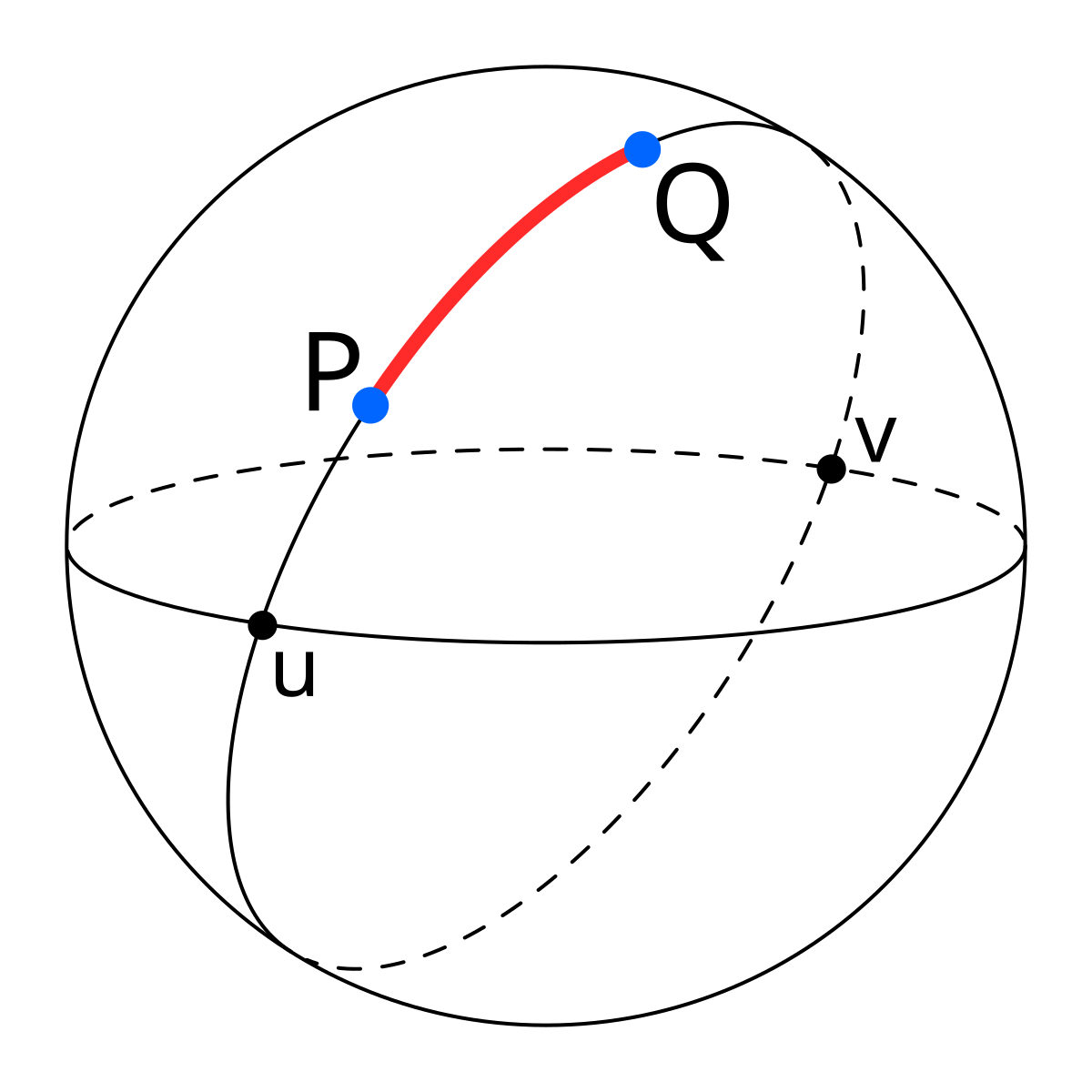
great circle distance
the shortest distance between two points on a spherical surface
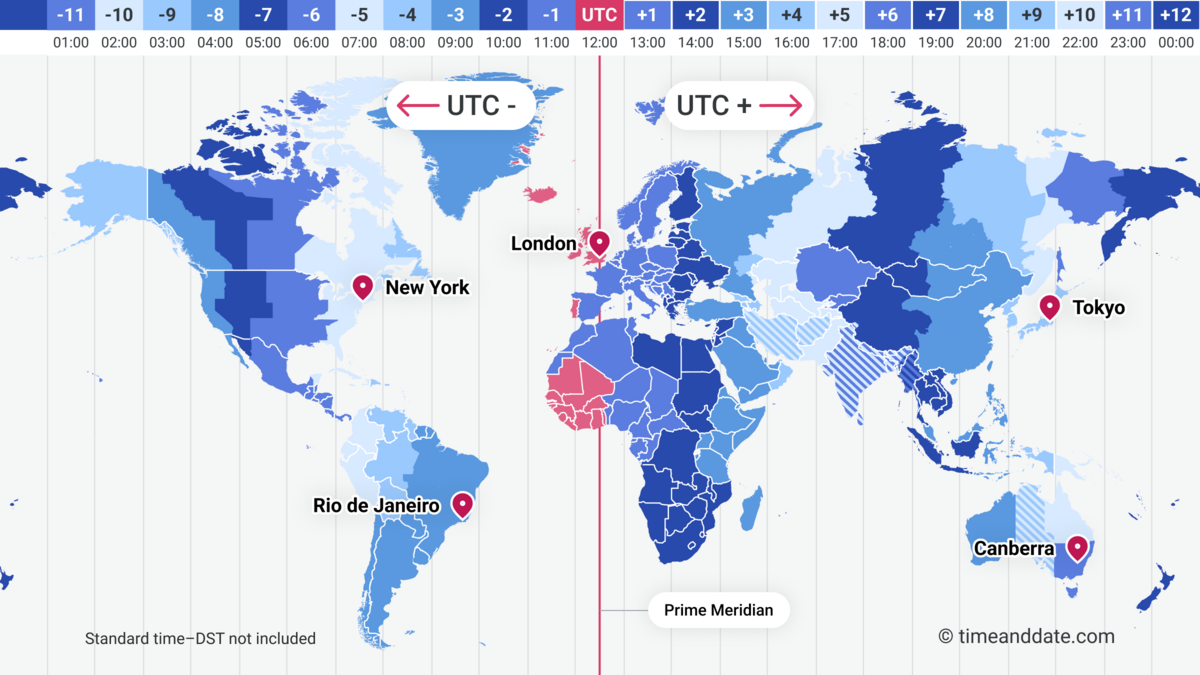
time zones
a method of measuring time around the world, created by dividing the world into subdivisions of longitude (15 degrees) and relating the time in each subdivision to the time in Greenwich, England
-The 50 U.S. states span six standard time zones
Why time zones don’t strictly follow longitude lines:
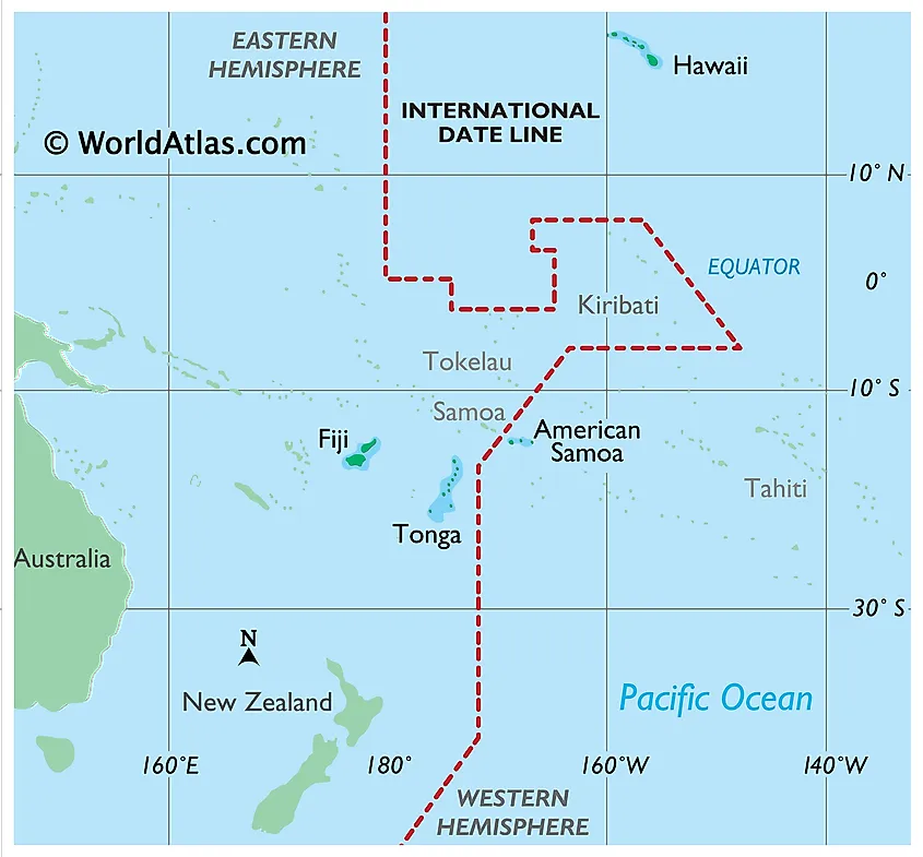
Political borders: Countries often adjust time zones to keep regions unified under one time.
Economic coordination: Some nations align with trading partners (e.g., Samoa shifted its time zone to match Australia/New Zealand).
Social convenience: Local solar time and population centers influence time zone boundaries.
International date line
a line of longitude that uses the 180th meridian as a basis (but deviates away from a straight line to accommodate geography)
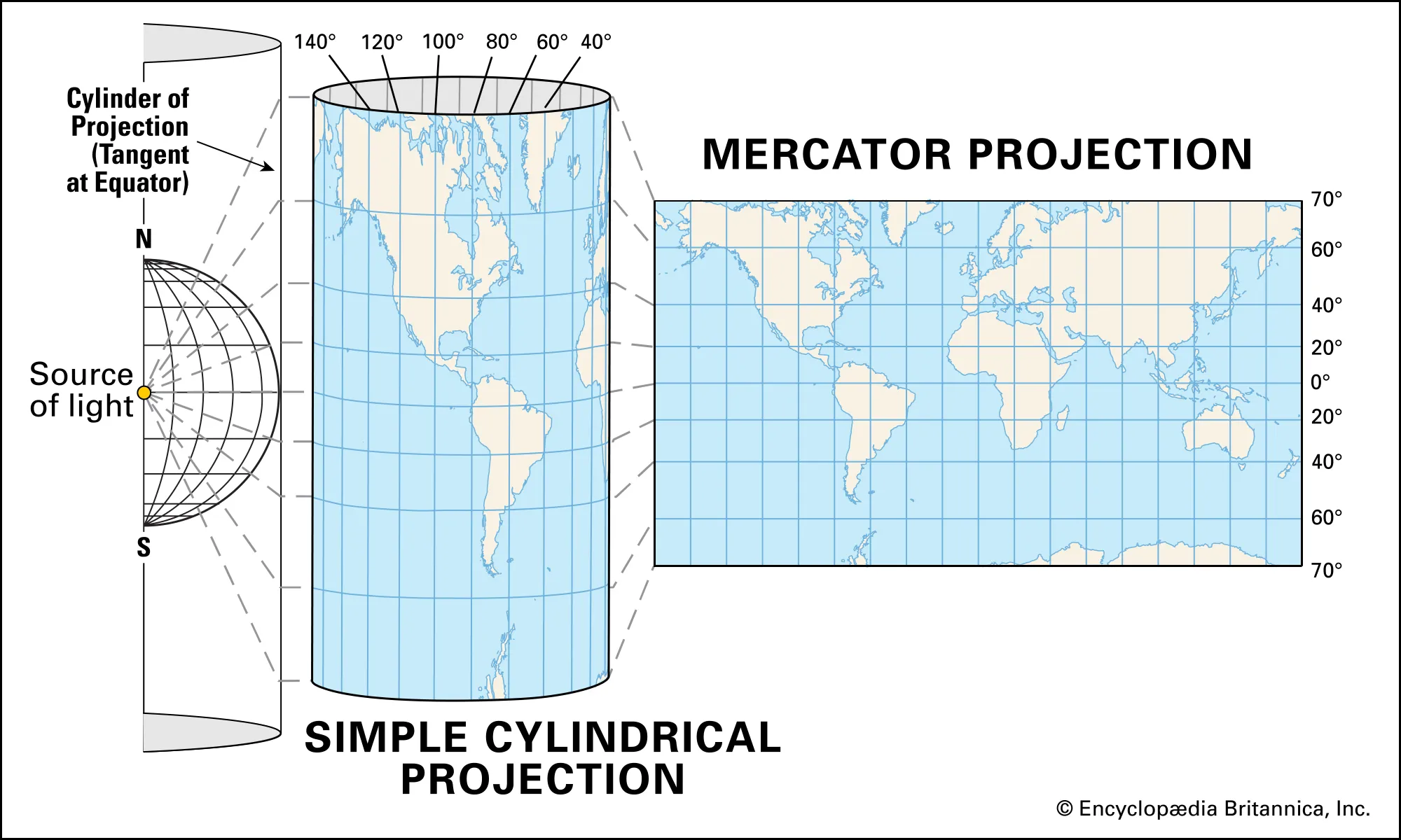
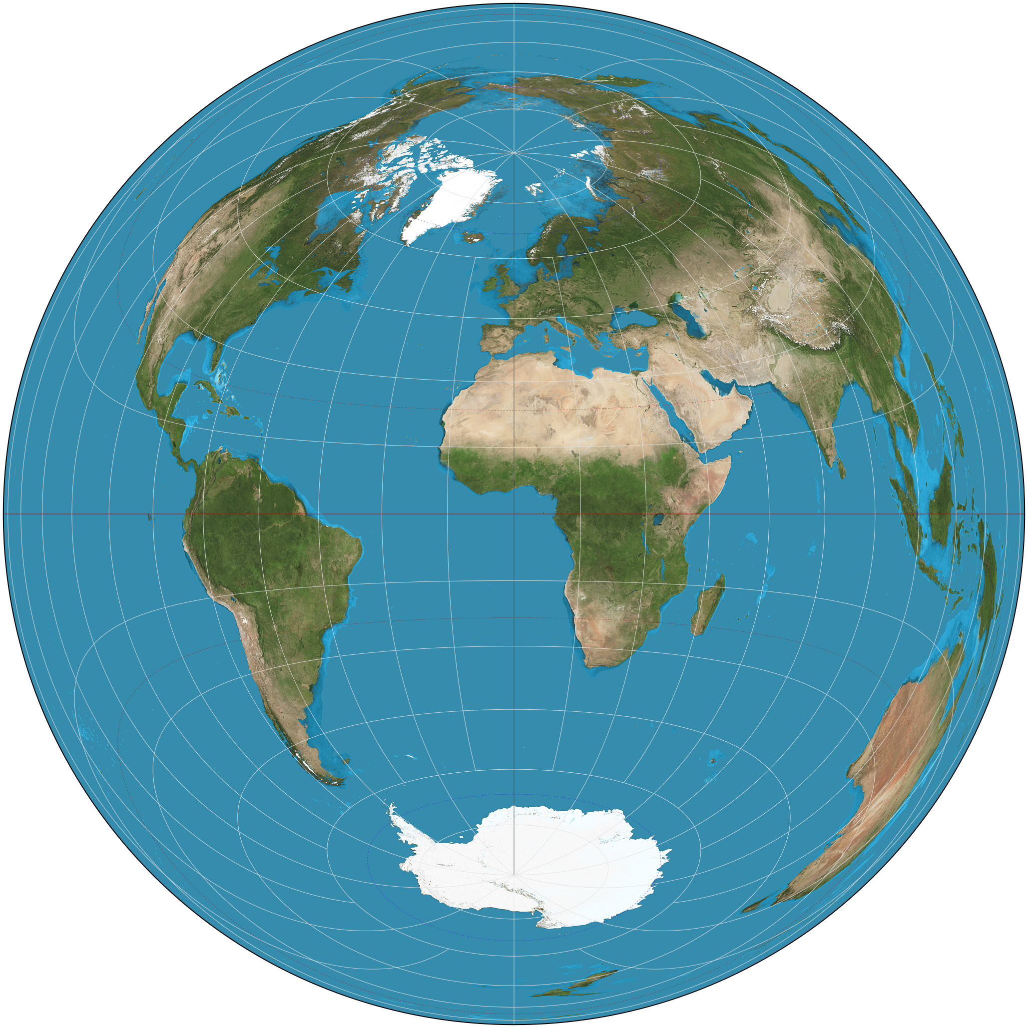
map projection
-the translation of locations on the three-dimensional (3D) Earth to a two-dimensional (2D) surface
created through the use of a developable surface or a flat area on which the features and locations from Earth can be projected.
The purpose is to transform the curved surface of the Earth into a flat representation, allowing geographic data to be visualized, measured, and analyzed on maps. Each projection serves different goals—some preserve shape, others area, distance, or direction.
Universal Transverse Mercator (UTM)
- grid system works by dividing the world into a series of zones and then determining the x and y coordinates for a location in that zone
-divides the world into 60 vertical zones
-UTM grid is set up by translating real-world locations to where their corresponding places would be on a two-dimensional surface using the Transverse Mercator projection.
• UTM can’t be used for polar regions because it only covers Earth
between 84°N and 80°S.
-Zone XX, Easting, Northing
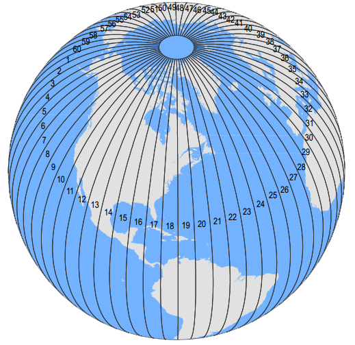
UTM zone
one of the 60 divisions of the world set up by the UTM system, each zone being 6 degrees of longitude wide
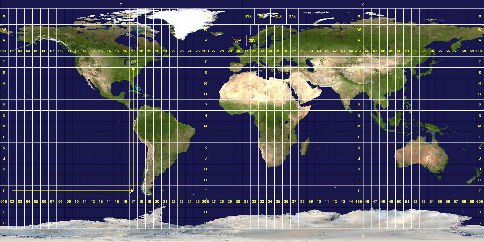
easting
a measurement of so many units east (or west) of some principal meridian
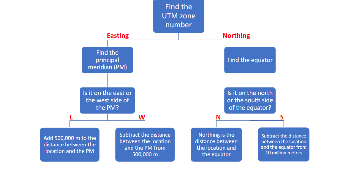
northing
a measurement of so many units north (or south) of a baseline

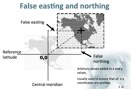
false northing
a measurement made north (or south) of an imaginary line such as is used in measuring UTM northings in the southern hemisphere
-In the S. hemisphere, UTM northing is the negative number of meters to the south of the Equator plus 10,000,000 meters. This extra 10 million meters is referred to as
false easting
a measurement made east (or west) of an imaginary meridian set up for a particular zone
-For the points to the east of the zone’s principal meridian, UTM easting is the number of meters to the east of the zone’s principal meridian plus 500,000 meters. This 500,000 meters given to the principal meridian is called
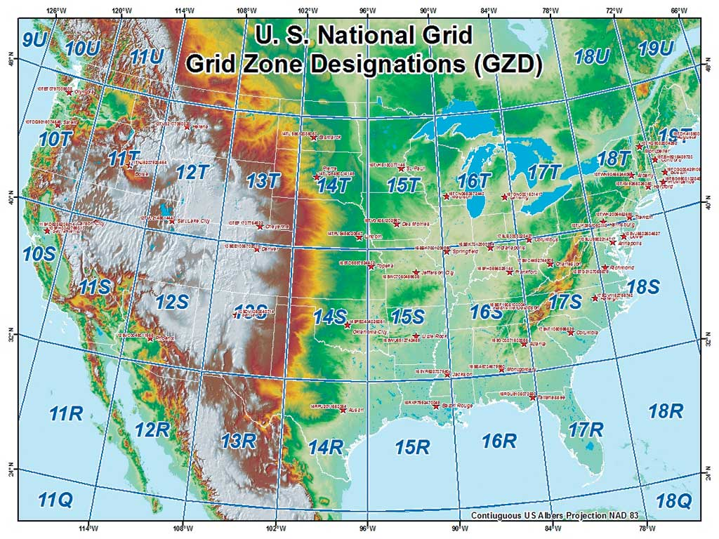
United States National Grid (USNG)
a grid system for identifying locations in the United States
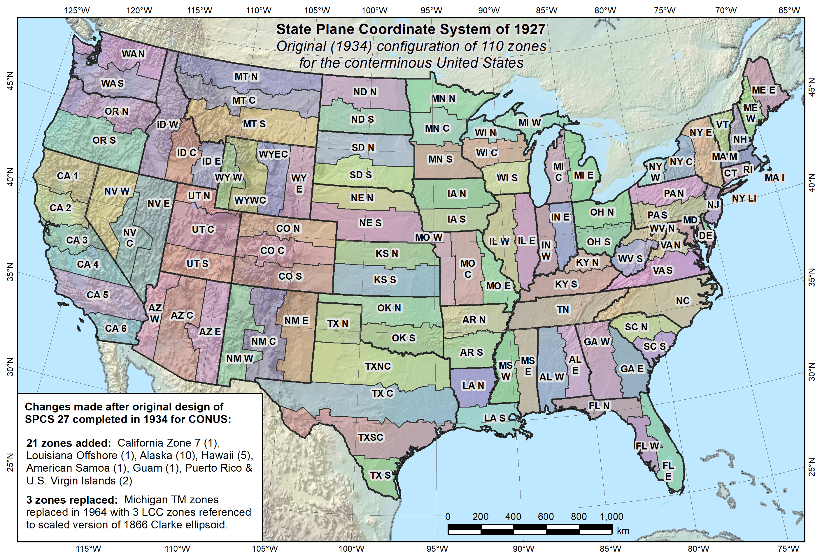
State Plane Coordinate System (SPCS)
a grid-based system for determining coordinates of locations within the United States
-zones are formed by following state or county
boundaries. Depending on the shape and size, a state is often divided into multiple zones.
• Each of the zones has its own baseline and its own
principal meridian.
• Measurements are made in feet or meters using the NAD83 datum.
NAD27 (North American Datum of 1927)
-Developed for measurements of the United States and the rest of North America
NAD83 (North American Datum of 1983)
Developed as the datum for the United States and the North American continent as a whole
NATRF2022 (North American Terrestrial Reference Frame of 2022)
-will replace NAD83
The new datums will rely primarily on Global Navigation Satellite Systems (GNSS) and a gravimetric geoid model
WGS84 (World Geodetic System of 1984)
used by the Global Positioning System & google earth
- a generalized ellipsoid model for the entire Earth.
-developed by the U.S. Department of Defense in 1984
Geospatial intelligence
uses geospatial technology for national security and defense applications
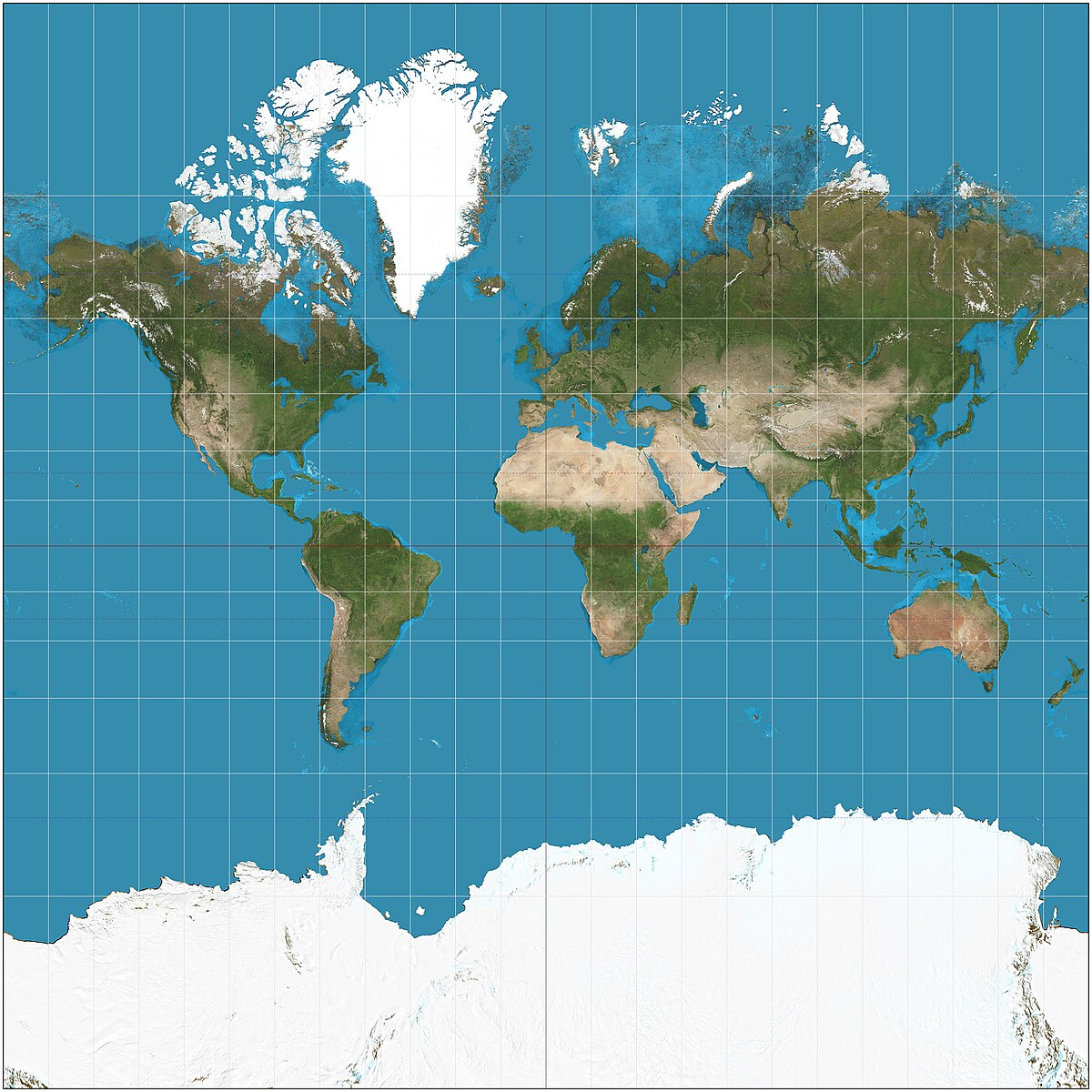
Mercator map projection
shapes remain intact but sizes are distorted
Universal Time Coordinated (UTC)
Time at any given place is calculated relative to how many hours ahead or behind the Prime Meridian (0˚ longitude).
• The beginning and end of each calendar day is the International Date Line (180˚ longitude).
Cylindrical projection
• The regions of greatest distortion occur at the top and the bottom of the map. Regions near the Equator have the least distortion.
-Mercator projection is one of the most well-known examples. This map projection maintains shape at the expense of size at high latitude regions.
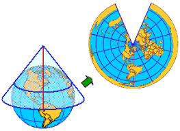
Conical projection
• Distortions are minimum along the tangent line where the cone touches the globe. Distortions become greater as you move
further away from the tangent line.
-Albers equal‐area projection. This map projection maintains
relative size but distort the shape.
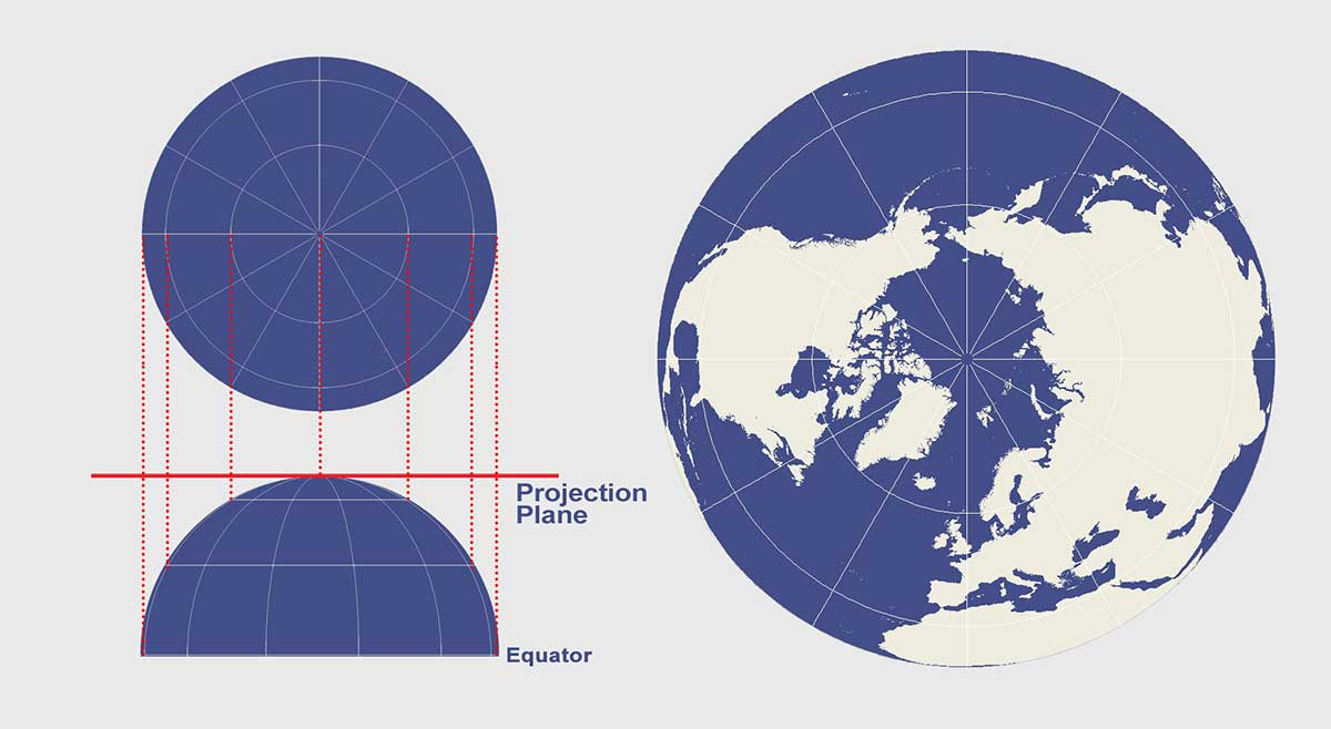
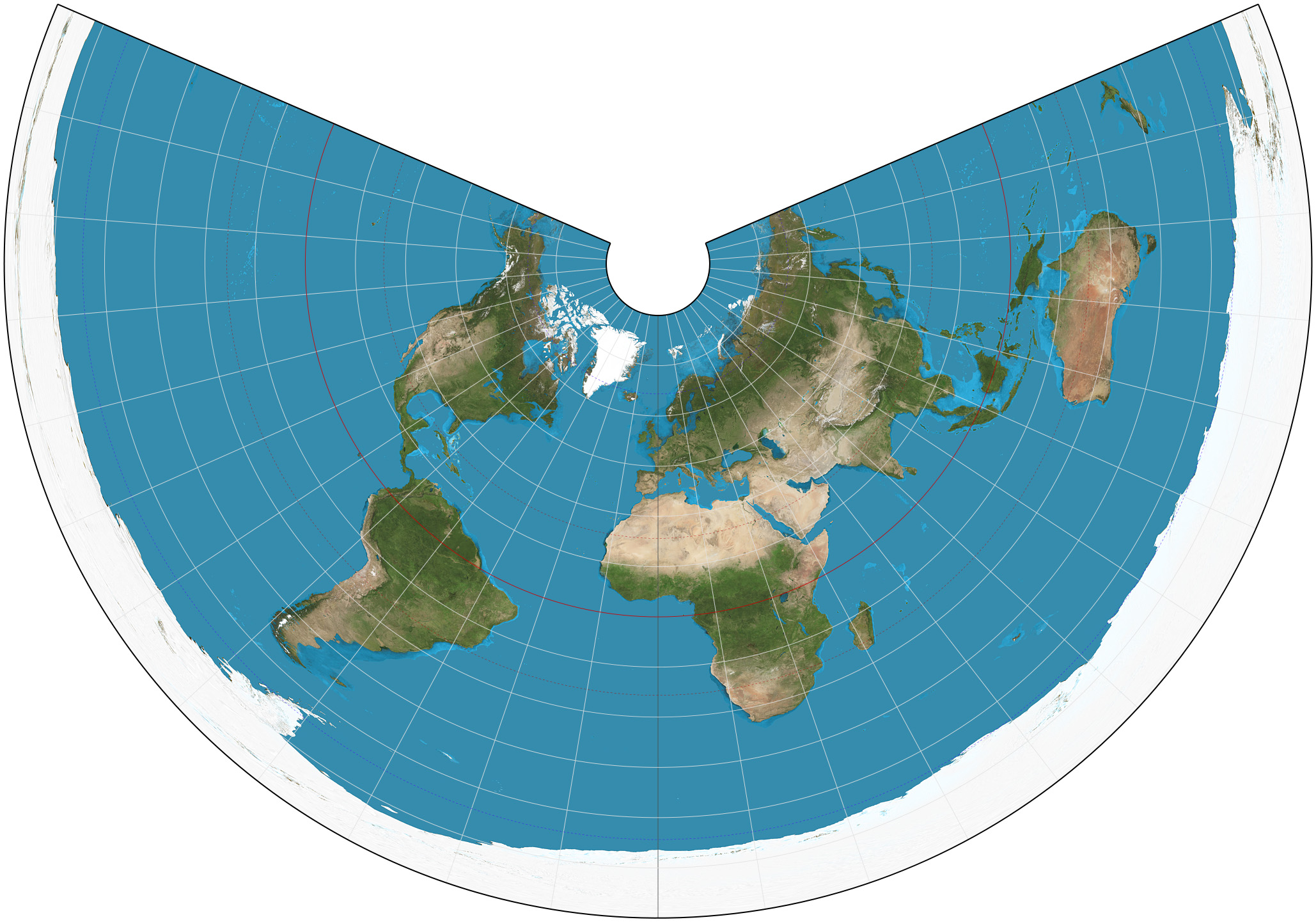
Azimuthal (Planar) Projection
• The plane is placed above the north or south pole. Normally only one hemisphere, or a portion of it, is represented
• The main features are straight meridian lines radiating out from the center. Parallels are circular around the center.
-It preserves distance and area in all regions of the sphere, but distorts the shape
- most appropriate for mapping polar regions with minimal distortion
To preserve shape
-Transverse Mercator
-Lambert conformal conic
To preserve area measure
-Albers conic equal-area
-Lambert cylindrical equal-area
-Lambert azimuthal equal-area
To preserve distance between points
-Azimuthal equidistant
-Equidistant conic
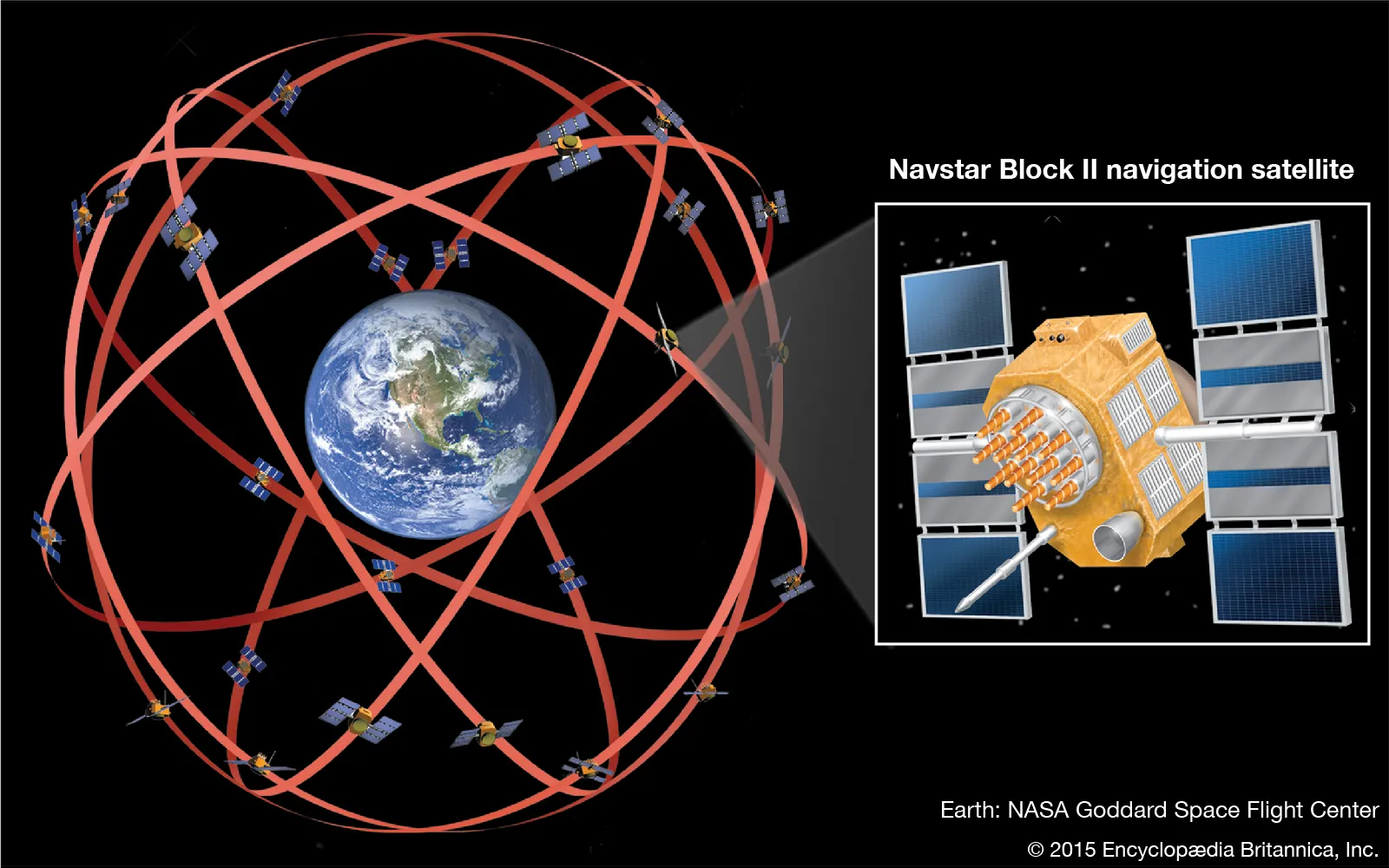
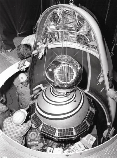
Navstar GPS
the U.S. Global Positioning System
the GNSS developed by the United States
As of today, the constellation consists of 31 operational satellites, which are maintained and overseen by the U.S. Space Force (formerly the U.S. Air Force).
GNSS (global navigation satellite system)
an overall term for the technologies that use signals from satellites to find locations on Earth’s surface
Other countries and regions have their own:
• European Union’s Galileo system
• Russia’s Global'naya Navigatsionnaya Sputnikovaya
Sistema (GLONASS)
• China’s BeiDou Navigation Satellite System
• India’s NavIC (Navigation with Indian Constellation)
• Japan’s QZSS (Quasi-Zenith Satellite System)
space segment
one of the three segments of GPS, consisting of the satellites and the signals they broadcast from space
control segment
one of the three segments of GPS, consisting of the ground control stations that monitor the signals from the GPS satellites
Ground stations collect satellite data, make corrections, and upload new data to the satellites to make sure satellites broadcast correct information.
user segment
one of the three segments of GPS, consisting of the GPS receivers on the ground that pick up the signals from the satellites
channels
the number of satellite signals a GPS unit can receive
-more ____ =higher accuracy
almanac
data concerning the status of a GPS satellite that is included in the information being transmitted by the satellite
ephemeris
data that refers to a GPS satellite’s position in orbit
C/A code
the digital code broadcast on the L1 frequency, which is accessible by all GPS receivers
P code
the digital code broadcast on the L1 and L2 frequencies, which is accessible by a military receiver
Y code
an encrypted version of the P code
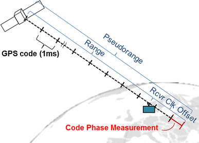
pseudorange
the calculated distance between a GPS satellite and a GPS receiver
trilateration
the process of finding a location in relation to three points of reference
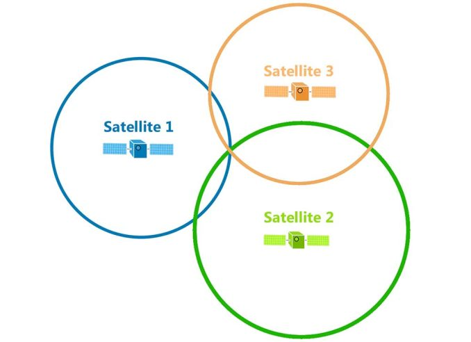
3D trilateration
the process of finding a location on Earth’s surface in relation to the positions of three satellites
selective availability
the intentional degradation of the timing and position information transmitted by a GPS satellite
multipath
an error caused by a delay in a signal due to reflecting from surfaces before reaching the receiver
DGPS (differential GPS)
a method of using a ground-based correction in addition to satellite signals to determine position
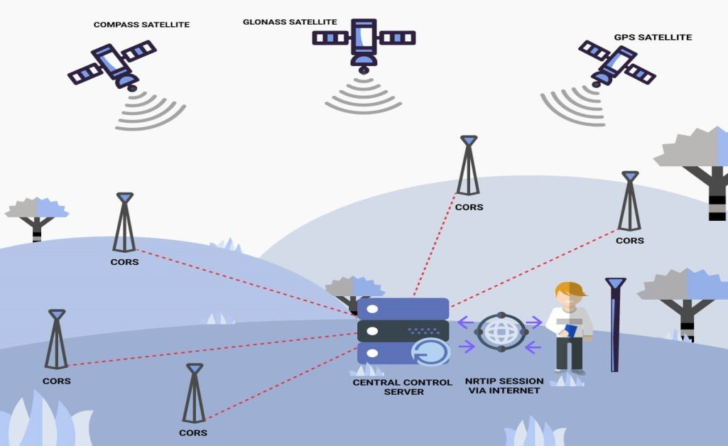
CORS (Continuously operating reference systems)
a system operated by the National Geodetic Survey to provide a ground-based method of obtaining more accurate GPS positioning
SBAS (satellite-based augmentation system)
a method of using correction information sent from an additional satellite to improve GPS position determination
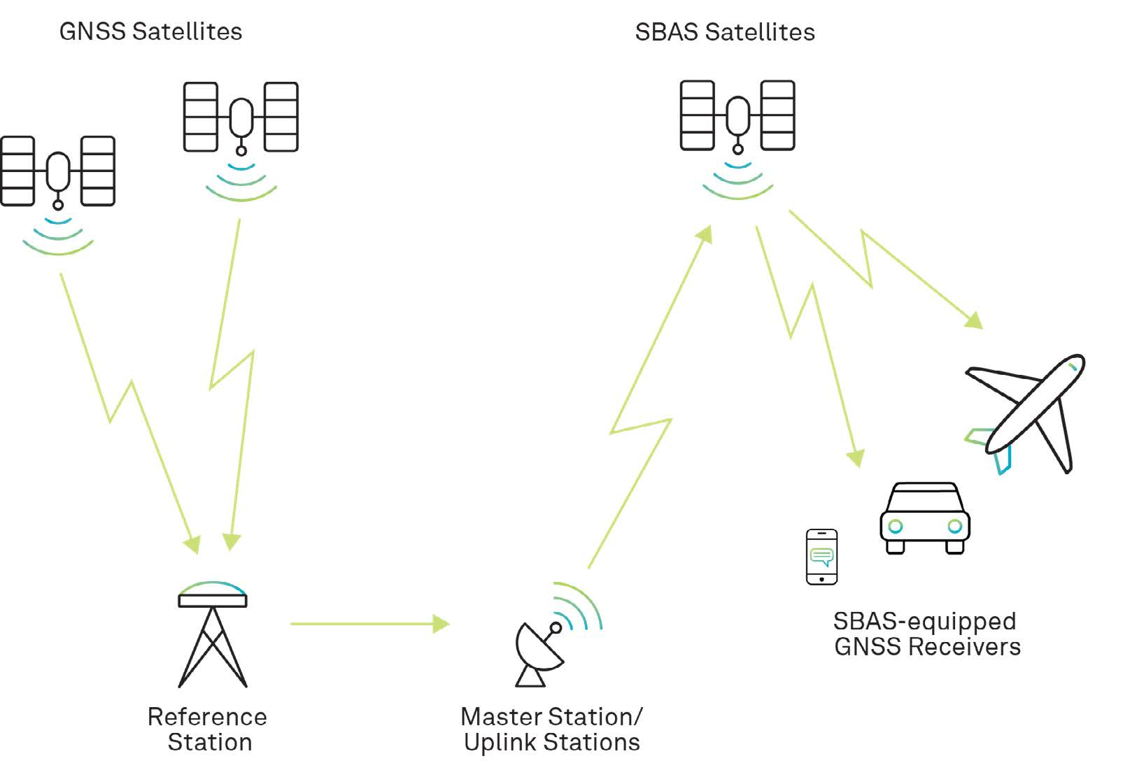
WAAS (Wide area augmentation system)
a satellite-based augmentation system that covers the United States and other portions of North America
GPX
a standard file format for working with GPS data collected by GPS receivers
geocaching
using GPS and a set of coordinates to find locations of hidden objects
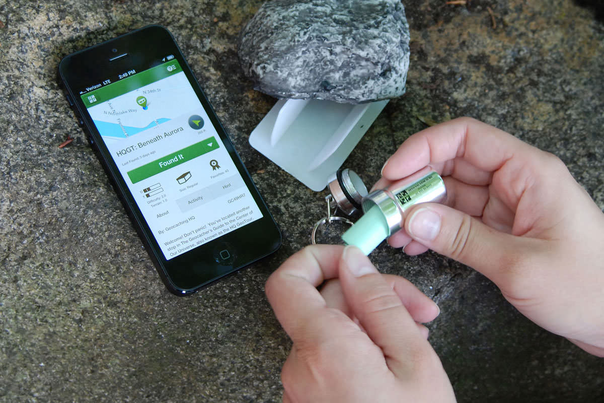
geocoin
a small coin used in geocaching that has a unique ID number that allows its changing location to be tracked and mapped
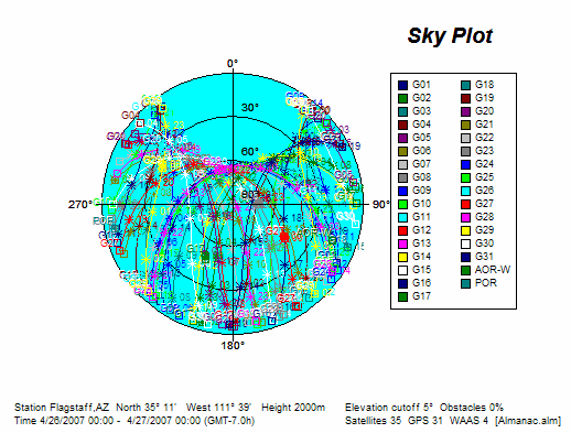
Position dilution of precision
The error introduced by a poor geometric arrangement of GPS satellites
Transit
The first satellite navigation system, was developed by the U.S. Navy in 1964 to determine the locations of seagoing vessels.
Constellation
A group of satellites working together as a system
-The minimum number of satellite for a full ___ is 24 arranged in 6 orbital planes, with 4 satellites per plane. Each GPS satellite orbits Earth twice per day.
Single frequency
(or single-band) receiver
- only picks up L1 frequency
Dual frequency
(or dual band) receiver
-picks up both L1 and L2 frequencies
Canadian Geographic Information system (CGIS)
a large land inventory system developed in Canada and the first system of this type to use the term “GIS”
discrete object view
a conceptualization of the world in which all reality can be represented by a series of separate objects
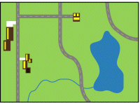
Points
These are zero-dimensional objects, simple sets of coordinate locations.

Lines
These are one-dimensional objects, created by connecting starting and ending points (and any points in between that give a line its shape).

Polygons
These are two-dimensional objects that form an area from a set of lines (or having an area defined by a line forming a boundary).
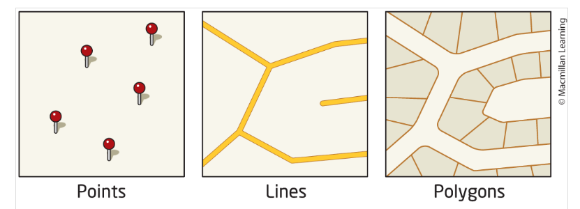
vector objects
points, lines, and polygons that are used to model real-world phenomena using the vector data model
vector data model
a conceptualization of the world that represents spatial data as a series of vector objects (points, lines, and polygons)
digitizing
creating vector objects through sketching or tracing representations from a map or an image source
topology
how vector objects relate to each other (in terms of their adjacency, connectivity, and containment), independently of the objects’ coordinates
-refers to the spatial association between vector features and objects.
• Three basic relationships:
• Connectivity – how features are connected to each other
• Adjacency – distance between features
• Enclosure – whether features are nested or apart from each other
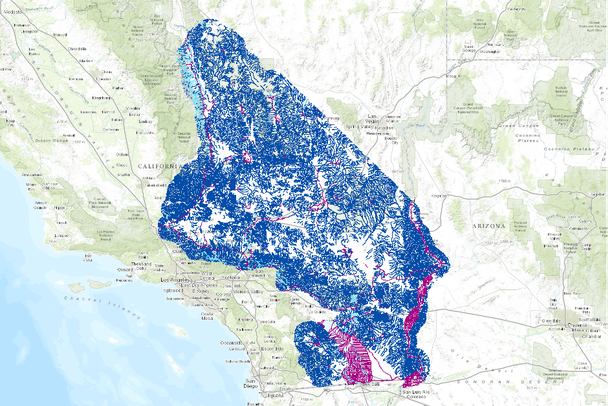
National Hydrography Dataset (NHD)
a collection of GIS data of water resources for the United States
continuous field view
a conceptualization of the world in which all items vary across Earth’s surface as constant fields, and values are available at all locations along the fields
raster data model
a model for representing spatial data that utilizes a series of equally spaced and sized grid cells
exp: satellite images & aerial photographs
-used to represent continuous features.
• Data is represented using a set of evenly distributed square grid cells, with each cell representing an area on Earth’s surface.
• These grid cells are also often called pixels or rasters.
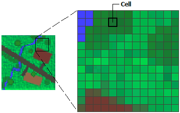
grid cell
a square unit, representing some real-world size, that contains a single value
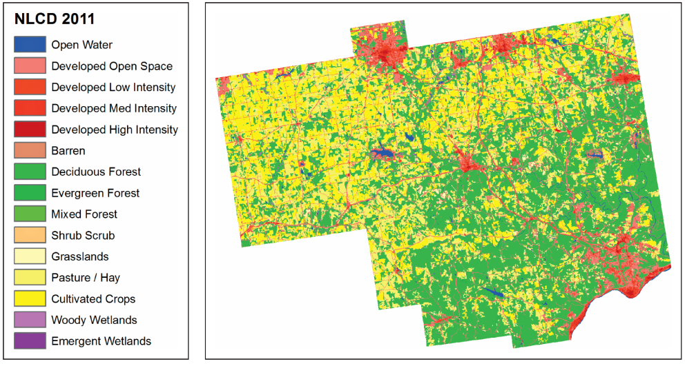
National Land Cover Database (NLCD)
a raster-based GIS dataset that maps the land-cover types for the entire United States at 30-meter resolution