Geography GCSE - Glaciers
1/42
There's no tags or description
Looks like no tags are added yet.
Name | Mastery | Learn | Test | Matching | Spaced |
|---|
No study sessions yet.
43 Terms
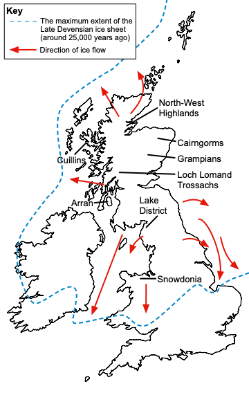
What was the extent of ice cover across the UK during the last ice age?
What are the Glacial processes?
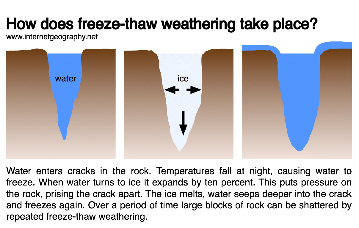
Freeze-thaw weathering
Erosion - plucking & abrasion
Movement & Transportation - rotational slip & bulldozing
Deposition - why glaciers deposit sediment (till and out wash)
Freeze-thaw weathering
Plucking
Blocks of rock are pulled away by ice as it moves downhill
Melt water gets into crevices, freezes and pulls pieces of rock away
Abrasion
Sharp angular rocks are embedded in the ice (from plucking)
As ice moves rocks scratch & scrape against the surface of the valley
Larger boulders - serious damage to landscape (striations)
Relationship between plucking and abrasion
Plucking first then abrasion
—> The plucked rocks are the ones used in abrasion
More plucking = more rocks & boulders embedded in ice so increased rate of abrasion
Bulldozing
Bulldozing is when the glacier destroys everything in its path when it is moving
How does the glacier move (basal sliding)
Weight of ice increases pressure at the base of the glacier
This increases warmth at the base of the glacier
This in turn increases melting meaning melt water is present
This melt water provides lubrication allowing the glacier to slide over the surface
Gravity causes the movement to be downhill
This is known as basal sliding
Rotational slip
Snowflakes collect in a hollow in the valley
More snow falls —> more snow is compressed
Air is squeezed out of the hollow so the snow becomes firn
With pressure of more layers of snow (over a thousand years) firn will become glacier ice
The glacier ice is trapped in hollow - unable to move but gravity encourages it to move
It moves out of the hollow in a circular motion called rotational slip
How can glaciers carry material?
Above glacier/on surface - F.T.W. causes block of rock to become detached/fall onto the ice from surrounding mountains
Inside - Rocks might fall into the glacier from F.T.W or buried in snowfall overtime
Beneath glacier - plucking has torn away rock from the base of the glacier
Glacial Outwash
Out wash is material (sand/gravel) that has been deposited by melt water streams in front & underneath a glacier
Large material is deposited first as it is heavier and takes more energy to carry
Fine material is deposited furthest from the glacier
Sediment has been rounded & reduced in size by attrition because it is carried in water
Sorted material
Glacial Till
Sediment is carried by ice and deposited in front of the glacier
No attrition/abrasion has occurred because it was carried by ice
So sediment is jagged and angular
Sediment is not sorted (different sizes and shapes)
What is a corrie
A deep depression on a hillside with a steep back wall often containing a lake (‘armchair’ shape)
Names:
England & Scotland - Corries
Wales - Cwns
France - Cirques
Formation of a corrie
A. Beginning of glacial period
Snow accumulates in a hollow, compressed into firn
B. During glacial period
Rotational slip gouges out the hollow
—> Plucking steepens the back wall
—> Abrasion deepens the hollow
F.T.W happens above the glacier
C.After glacial period
Steep back wall (still F.T.W during winter)
Corrie lake (tarn) - melted glacier
Deep rock basin
Scree
Jagged summit (due to F.T.W)
Rock lip
What are Aretes and how are they formed?
Arete is a sharp ridge of rock found between to corries
Formed when two corries are formed back to back
What is a Pyramidal Peak and how are they formed
A pyramidal peak is formed when three or more corries grow in hollows on all sides of a mountain.
As the corries erode the mountain behind them, the remaining rock is weathered into a sharp point.
What is a glacial trough (u-shaped valley)
A glacial trough is a valley with steep sides and a flat base, once occupied with a glacier
Formation of glacial trough (& truncated spurs & ribbon lakes)
Before glaciation:
There is a v-shaped valley with a river through it
The river meanders around interlocking spurs
During glaciation:
Glacier forms in the v-shaped valley
The glacier widens, deepens, steepens & straightens the valley by plucking and abrasion
After glaciation:
After the glacier melts an over-deepened glacial trough/u-shaped valley remains
It may be occupied by a ribbon lake/misfit stream
It has a flat valley floor, steep valley sides and shoulders
The interlocked spurs have become truncated spurs through erosion
What is a hanging valley
High-level tributary valleys from which there is a sharp fall to the level of the lower, main valley
Formation of a hanging valley (& ribbon lake)
Before glaciation:
There is a v-shaped valley
The main river in the v-shaped valley meanders around interlocking spurs
There is a tributary valley in the side of the v-shaped valley
A tributary river flows in the v-shaped valley which creates a confluence of main and tributary rivers
During glaciation:
Ice occupies the valleys, widening, steepening, deepening & straightening them by plucking and abrasion
There is a larger glacier in the main valley
There is a smaller glacier in the tributary valley so less erosion occurs compared to the large valley
After glaciation:
There is a main glacial trough/ u-shaped valley
—> Steep valley sides with truncated spurs
—> May be occupied by a misfit stream/ribbon lake
Due to difference in erosion, tributary valley is left hanging above the main valley - hanging valley
—>normally has a waterfall in it which connects to the misfit stream/ribbon lake
What are ribbon lakes
Long, narrow lakes on the floor of a glacial valley
What are misfit streams
Small streams in a large glaciated valley - are not in proportion with the size of the valley
Characteristics of drumlins
Smooth hills
30-40 m high & 300-400 m long
Blunt at one end tapered at another (egg-shaped)
Formation of Drumlins
Ice is pushing across a lowland area nut it’s overloaded and melting
The ice does not need much to encourage deposition; any small obstacle such as a rock outcrop or mound is sufficient
Most deposition occurs around the upstream end of the obstacle which forms the blunt end of the drumlin
The rest of the moraine that is deposited is then moulded into shape around the obstacle by the moving ice to form the tapered end downstream
What are erratics?
An erratic is a rock or boulder that differs from the surrounding rock and has been transported by ice over a long distance and deposited by a melting glacier.
What are the 4 types of morraine
Lateral, Medial, Ground, Terminal
What is lateral moraine
Lateral means towards the sides.
A lateral moraine is a ridge of material found along a U-shaped valley’s edge.
This material comes from freeze-thaw weathering along the sides of the valley causing shattered blocks of rock to fall onto the glacier below
The material is deposited on the valley floor as the glacier melts.
What is medial moraine
Medial means in the middle.
When two glaciers meet side-by-side, the lateral moraines join to form a ridge of rock.
When the ice melts, the material is deposited in the centre of a U-shaped valley.
What is ground moraine
Ground moraine is the material that is frozen to the glacier’s base
and gets stuck and deposited underneath the glacier on the valley floor
What is terminal moraine
Terminal means end.
This material is found at the glacier’s end or snout.
It is material that the glacier has bulldozed.
It is usually a large ridge of material (indicating the distance a glacier has travelled).
An example of an upland area in the UK affected by glaciation to identify its major landforms of erosion and deposition
The Lake District
Location:
North-west of England
Near the border between Scotland & England
What are some economic activities in upland glaciated areas
Forestry, Farming, Tourism & Quarrying
Forestry in upland glaciated areas
Benefits:
Conifer trees are adapted to cope with the acidic soils (of U.G.A.)
They utilise steep slopes
Left to grow for 20-30 years before being felled
Produce ‘soft’ wood for timber in construction industry/Making paper
Negatives:
Has impacts on the environments
Increases CO2 emissions
Impacts animal habitats
Farming (Extensive agriculture) in upland glaciated areas
Benefits:
Ideal for extensive agriculture e.g animal grazing
Negatives:
Not ideal for farming
—> Glaciers stripped away soil and vegetation
—> Soils in these areas are thin and acidic
Tourism in upland glaciated areas
Benefits:
Provide employment for thousands of people
Can use area for outdoor activities - attracts tourists
Increases economic activity - profits
Negatives:
Can cause overcrowding leading to traffic congestion, litter etc.
—> bad for environment
Quarrying in upland glaciated areas
Benefits:
U.G.A.s made of hard resistant rock
—> can be quarried to provide stone for construction industry & building roads
Limestone in U.G.A - valuable resource used in chemical industry, conditioning soils, making cement
Negatives:
Destroys natural landscape
Noise pollution for locals & air pollution
Destroys animals habitats
Conflict between land uses e.g. Conflict between locals and tourists
Problems:
Increased litter
Traffic congestion - roads busy
Footpath erosion - visual pollution
Noise & air pollution - visitor traffic
Services may close as second home owners are not permanent residents
Solutions:
Put more bins
One-way systems, improved public transport
Stone paths, signs to direct walkers to alternative routes
Improve rail & bus services
Advertisement of housing in the area
Conflict between development & conservation
Arguments for development & against conservation:
More tourists will come
Provides more jobs for locals
Increases economic development
Arguments for conservation & against development:
Development likely to drove away visitors who come for peace and tranquility
Already huge range of activities
Development ruins the valleu
Need to conserve the natural beauty and heritage
Conserve plants and animals
—> Can also bring in tourists and retains the locals identity & culture
Attractions for tourists in the Lake District
Physical attractions:
Lakes (Windermere/Ullswater) - water sports, cruises, fishing
Mountain landscapes with peaks (Helvellyn, Scafell Pike) - walking mountain biking
Adventure activities - abseiling, rock climbing etc.
Cultural/Historical:
Landscape - inspired writes & poets (William Wordsworth)
Beatrix Potter - lived close to lake Windermere, her home now a national trust attraction
Scenic towns/villages (Ambleside/Grasmere)
Monuments (Muncaster castle)
Social impacts of tourism in the Lake District
Good
Lots of tourist - benefits local’s income so improves their quality of life
Bad
Over 89% visitors arrive by car
—> roads narrow & winding
—> major issue of congestion
House prices high
—> 20% of property either in holiday rental/ second homes
Jobs in tourism mostly seasonal
—> poorly paid & unreliable
Economic impacts of tourism in the Lake District
Good
Tourists spend a lot of money
—> in 2014 spent £1000 million
—> supports hotels, shops & restaurants
Thousands of local people have work opportunities
—> in shops, hotels & other services
—> provides them income
New businesses
—> e.g adventure tourism
—> provide jobs for local people
Bad
Traffic congestion
—> slows down business communications
Environmental impacts of tourism in the Lake District
Only Bad
Main tourist (‘honeypot’) sites & footpaths show signs of overcrowding
—> footpath erosion, litter, damage to verges by cars
Pollution from vehicles & boats
—> damage ecosystems
Walkers can damage farmland by trampling crops/leaving litter
—> Dogs can disturb sheep & cattle
What are the strategies used to manage the impact of tourism in the Lake District
Managing Traffic congestion:
Several dual-carriageways built - improve access
Transport hubs e.g. at Ambleside - help create an interchange between parking, buses, ferries walking & cycling
—> helps to relieve congestion elsewhere
Park and ride bus schemes e.g. ‘Honister Rambier’ have been expanded
Traffic calming measures e.g speed bumps introduced in villages
Managing footpath erosion:
The Upland Path Landscape Restoration Project
—> successfully repaired & re-surfaced paths & created steps with local stone and re-planted native plants