Geologic Mapping
1/178
Earn XP
Description and Tags
Name | Mastery | Learn | Test | Matching | Spaced | Call with Kai |
|---|
No analytics yet
Send a link to your students to track their progress
179 Terms
Elements and processes of structural geology
…
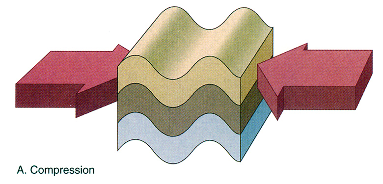
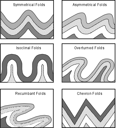
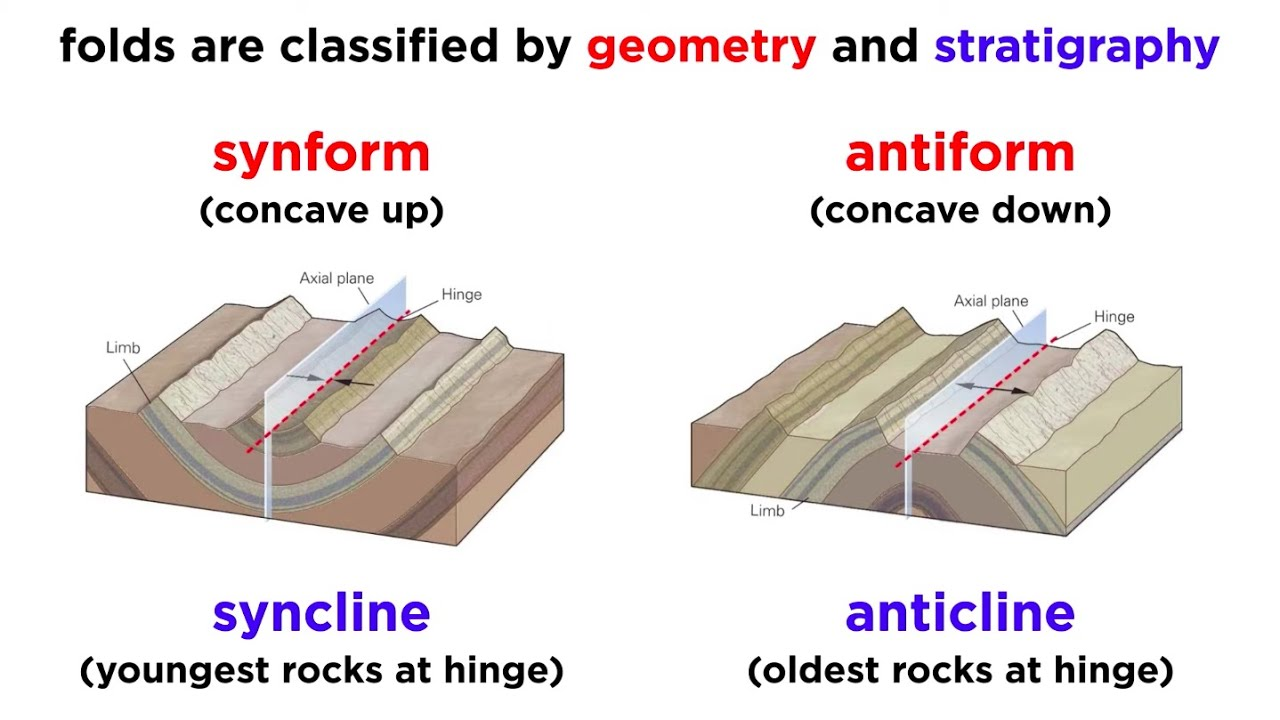
Surface Structural Elements: Folds
Bends or warps in rock layers caused by compressional stress.
Surface Structural Elements: Folds - Anticlines
Upward-arching folds (oldest rocks at the core).
The tops of folded rock formations (made that way by compression/ heat)
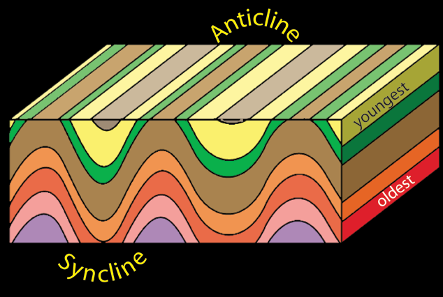
Surface Structural Elements: Folds - Synclines
Downward-arching folds (youngest rocks at the core).
The bottom of folded rock formations

Surface Structural Elements: Folds - Monoclines
Step-like bends in otherwise horizontal rock layers.
Single-step folds connecting horizontal layers

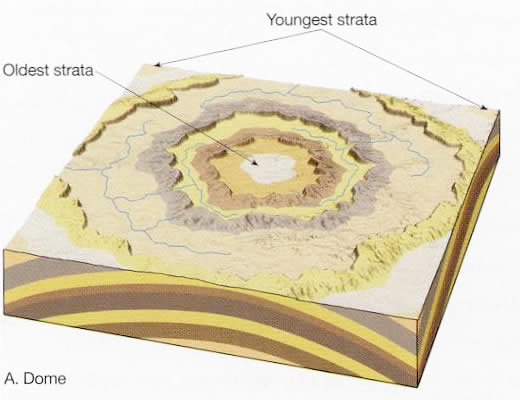
Surface Structural Elements: Folds - Dome
Circular or elliptical uplifted region.
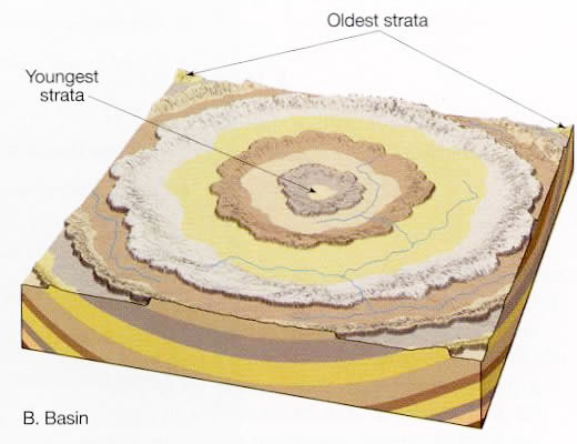
Surface Structural Elements: Folds - Basin
Circular or elliptical depressed region.
Surface Structural Elements: Faults
Faults are fractures in the Earth's crust where rock blocks move relative to each other due to tectonic forces.
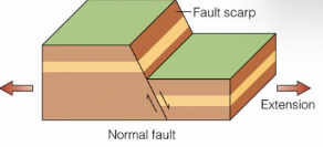
Surface Structural Elements: Normal Fault
Extension causes one block to move downward.
Hanging wall moves down relative to the footwall.
Bound to mountain ranges and rift valleys along spreading margins of tectonic plates
Common in rift zones and mid-ocean ridges.
Very common
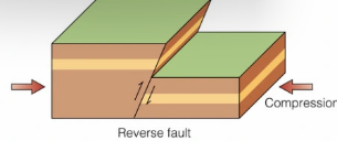
Surface Structural Elements: Reverse Fault (“Dip Slip”)
Compression forces one block to move upward.
Hanging wall moves up relative to the footwall.
Common in mountain-building zones (e.g., Himalayas).
Surface Structural Elements: Thrust Fault
Low-angle reverse fault (>45 degrees); commonly associated with mountain building.
A shallow reverse fault where older rocks are pushed over younger rocks.
Common in collision zones (e.g., Rocky Mountains).
Typically form ramps, flats, and fault-bend fonds
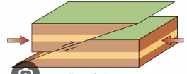
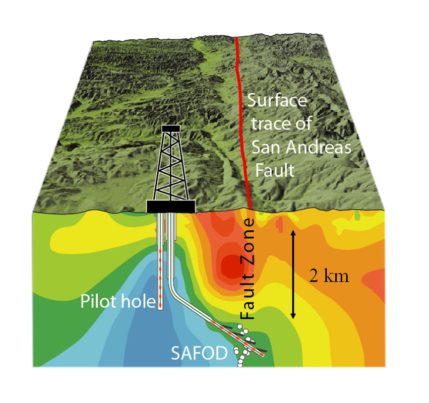
Surface Structural Elements: Strike-Slip Fault (Transcurrent, wrench, lateral)
Lateral movement (e.g., San Andreas Fault)
Blocks move horizontally past each other.
Common in transform boundaries (e.g., San Andreas Fault).
Due to the fault being displaced in a horizontal direction, parallel to the line of the fault
Surface Structural Elements: Joint Systems
Joints are fractures without displacement, often due to cooling, stress, or pressure release.
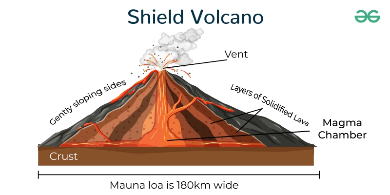
Surface Structural Elements: Volcanic Structures - Shield Volcanoes
Broad, gently sloping structures formed by low-viscosity lava (e.g., Mauna Loa).
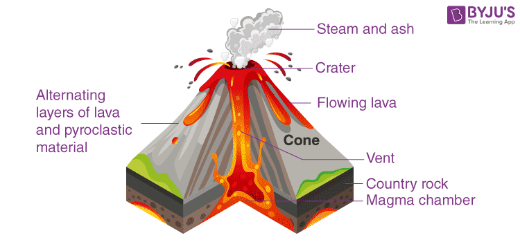
Surface Structural Elements: Volcanic Structures - Stratovolcanoes (Composite Volcanoes)
Steep, layered volcanic cones (e.g., Mount St. Helens).
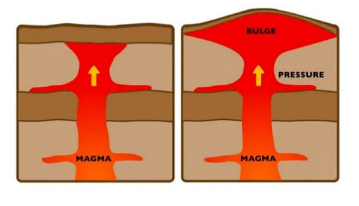
Surface Structural Elements: Volcanic Structures - Calderas
Large depressions formed after volcanic eruptions.
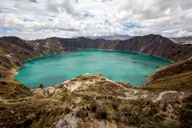
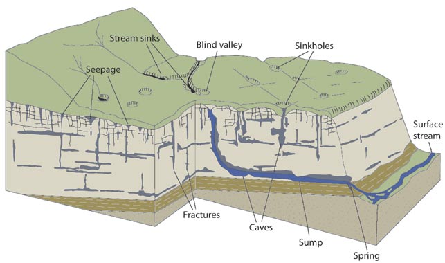
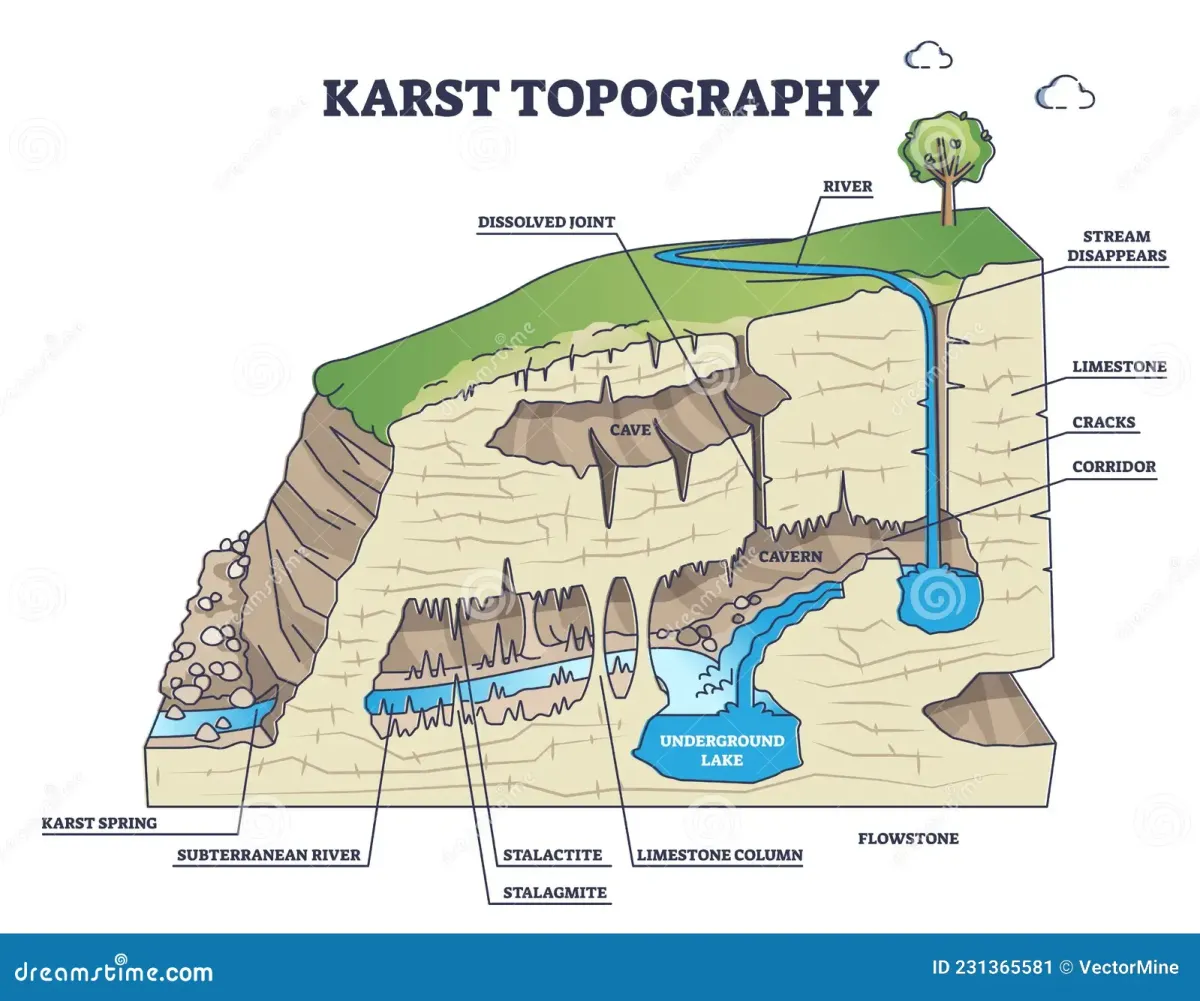
Surface Structural Elements: Karst Topography
Formed by dissolution of limestone, leading to sinkholes, caves, and underground rivers.
Subsurface Structural Elements:
These features lie beneath the Earth's surface and are studied using geophysical methods such as seismic imaging, drilling, and gravity surveys.
Subsurface Structural Elements: Tectonic Plates and Lithospheric Structures
…
Tectonic Plates and Lithospheric Structures: Crust
The outermost layer of the Earth, composed of continental and oceanic crust.
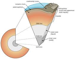
Tectonic Plates and Lithospheric Structures: Moho (Mohorovičić Discontinuity)
Boundary between the crust and mantle.
Seismic discontinuity, meaning there's a distinct change in seismic wave velocity as they pass through the Moho.
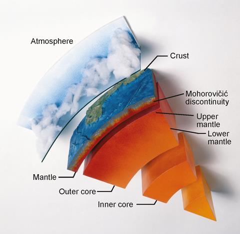
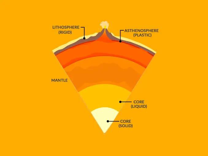
Tectonic Plates and Lithospheric Structures: Lithosphere
Rigid outer shell of the Earth, composed of the crust and upper mantle.
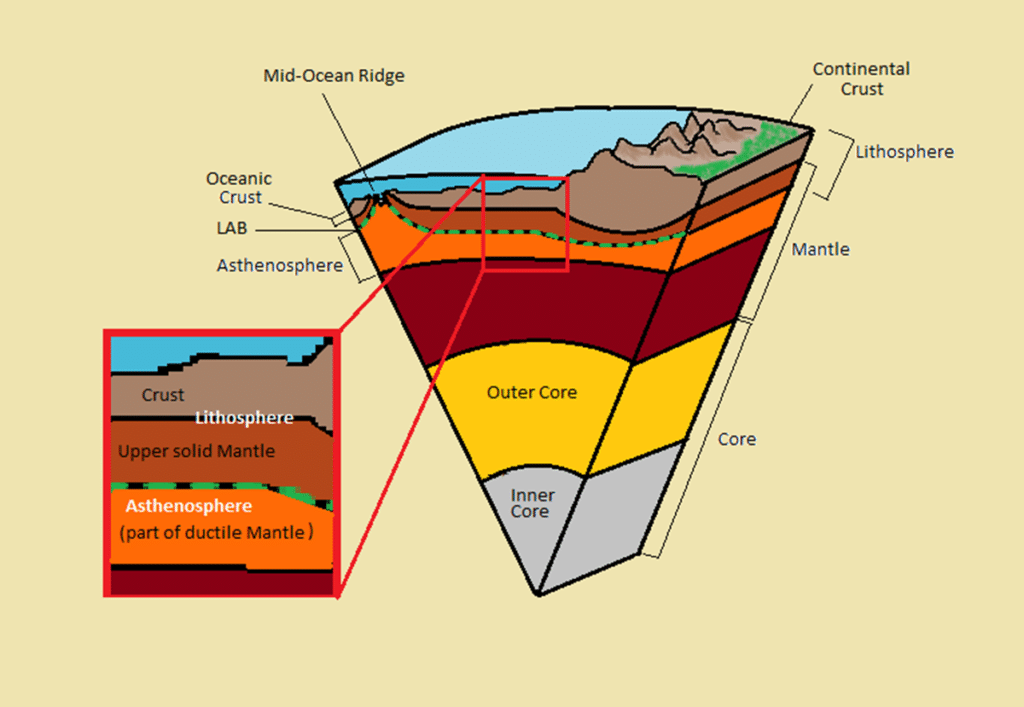
Tectonic Plates and Lithospheric Structures: Asthenosphere
Partially molten layer beneath the lithosphere that allows for plate movement.
Subsurface Fault Zones and Shear Zone: Fault Zones
Major fault systems extending deep into the Earth's crust (e.g., San Andreas Fault).
Systems of interconnected faults visible at the surface
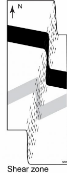
Subsurface Fault Zones and Shear Zone: Shear Zones
Regions where rocks deform plastically under high stress and temperature.
A thin, deformed area of Earth's crust or upper mantle where rocks on either side have slipped past each other
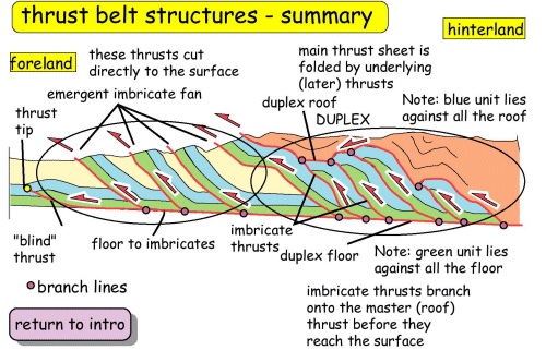
Folded and Thrust Belt Structures
Large-scale folded regions associated with continental collisions (e.g., the Appalachian Mountains).
Magmatic Intrusions and Plutonic Structures: Batholiths
Large, deep-seated intrusive igneous bodies (e.g., Sierra Nevada Batholith).
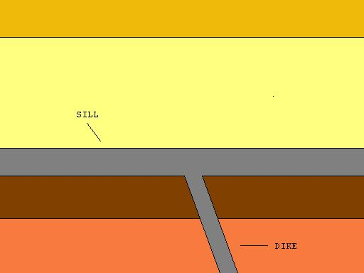
Magmatic Intrusions and Plutonic Structures: Sills and Dikes
Horizontal (sills) and vertical (dikes) intrusions of magma.
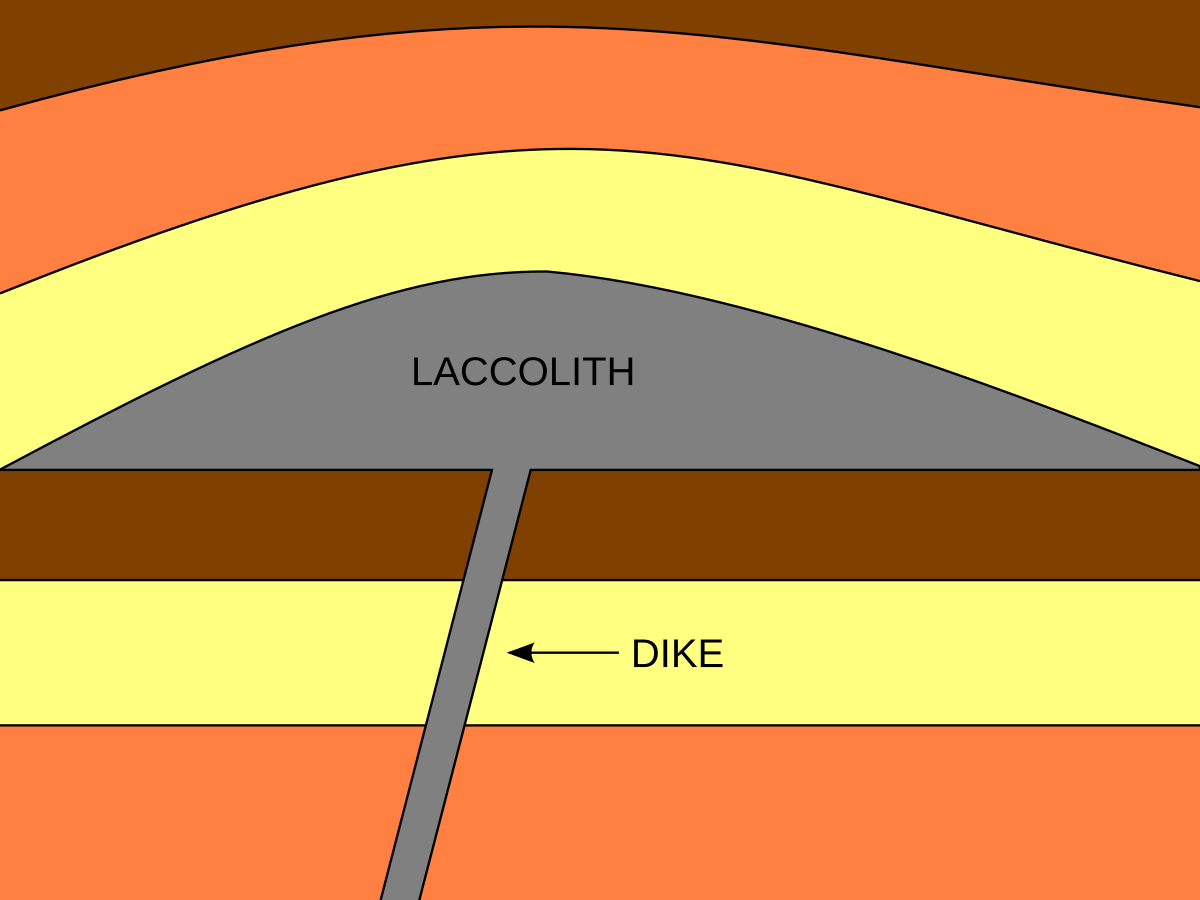
Magmatic Intrusions and Plutonic Structures: Laccoliths
Dome-shaped intrusions that push overlying rock layers upward. (filled by solidified magma)
Basin and Dome Structures: Sedimentary Basins
Large, subsiding regions where sediments accumulate (e.g., the Gulf of Mexico Basin).
Basin and Dome Structures: Structural Domes
Uplifted areas, often associated with salt diapirs or magmatic intrusions.
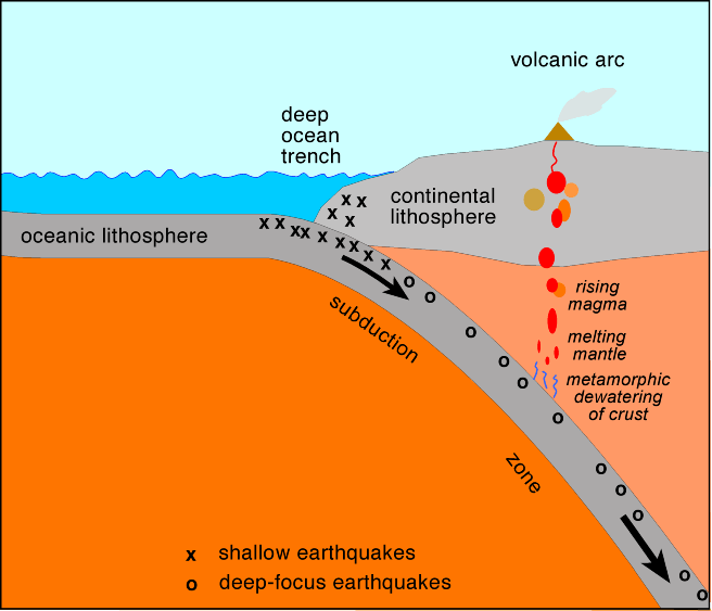
Subduction Zones and Deep Earth Features: Subduction Zones
Where one tectonic plate sinks beneath another (e.g., Mariana Trench).
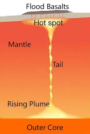
Subduction Zones and Deep Earth Features: Mantle Plumes and Hot Spots
Deep-seated upwellings of hot rock (e.g., Hawaii Hot Spot).
Deformation Forces
Deformation forces shape Earth's crust, leading to the formation of mountains, basins, rift valleys, and earthquake zones. Understanding these structures is essential for studying tectonic activity, natural hazards, and resource exploration.
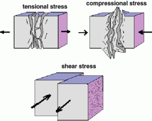
Deformation Forces: Compressional Stress
Definition: Rock layers are pushed together, reducing volume and causing shortening.
Associated Structures: Folds (e.g., anticlines, synclines), Reverse and Thrust Faults
Common Environments: Convergent plate boundaries (e.g., Himalayan Mountains).
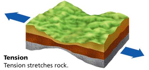
Deformation Forces: Tensile (Tensional) Stress
Definition: Rock layers are pulled apart, causing extension and thinning.
Associated Structures: Normal Faults, Horsts and Grabens (block faulting), Joints and Fractures
Common Environments: Divergent plate boundaries (e.g., Mid-Atlantic Ridge, Basin and Range Province).
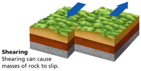
Deformation Forces: Shear Stress
Definition: Rock layers slide past each other in opposite directions.
Associated Structures: Strike-Slip Faults, Shear Zones
Common Environments: Transform plate boundaries (e.g., San Andreas Fault).
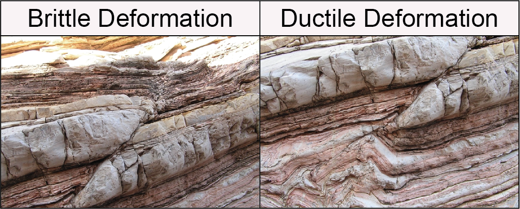
Associated Geological Structures: Folding (Plastic Deformation)
Occurs when rocks bend rather than break due to compressional forces.
Associated Geological Structures: Faulting (Brittle Deformation)
Occurs when stress exceeds the strength of rocks, causing fractures and displacement.
Depositional Sequences and Erosion Patterns of Different Lithologies and Structural Elements
The processes of deposition and erosion shape Earth's surface, forming distinct sequences of sedimentary layers and unique erosional patterns based on rock type (lithology) and structural features.
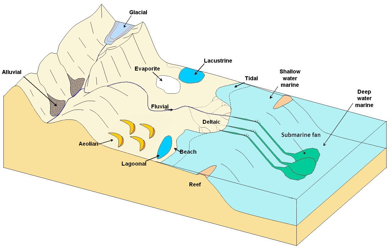
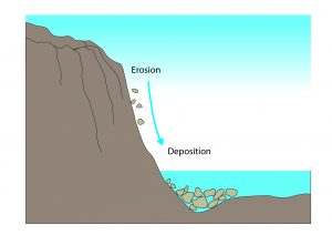
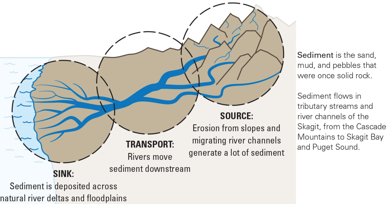
Deposition
Geological process in which sediments, soil and rocks are added to a landform or land mass. Wind, ice, water, and gravity transport previously weathered surface material, which, at the loss of enough kinetic energy in the fluid, is deposited, building up layers of sediment.
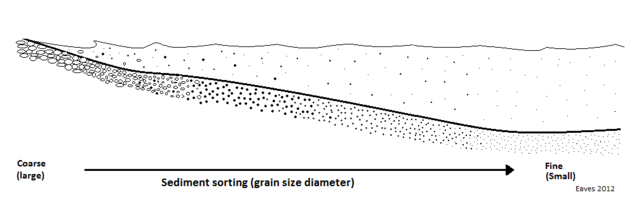
Null-point hypothesis
Explains how sediment is deposited throughout a shore profile according to its grain size.
Due to the influence of hydraulic energy, resulting in a seaward-fining of sediment particle size, or where fluid forcing equals gravity for each grain size.
Explained as "sediment of a particular size may move across the profile to a position where it is in equilibrium with the wave and flows acting on that sediment grain".
Depositional Sequences
A depositional sequence is a stratigraphic unit formed by sediment deposition over time, influenced by sea-level changes, sediment supply, and tectonic activity.
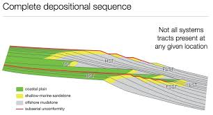
Controls on Deposition
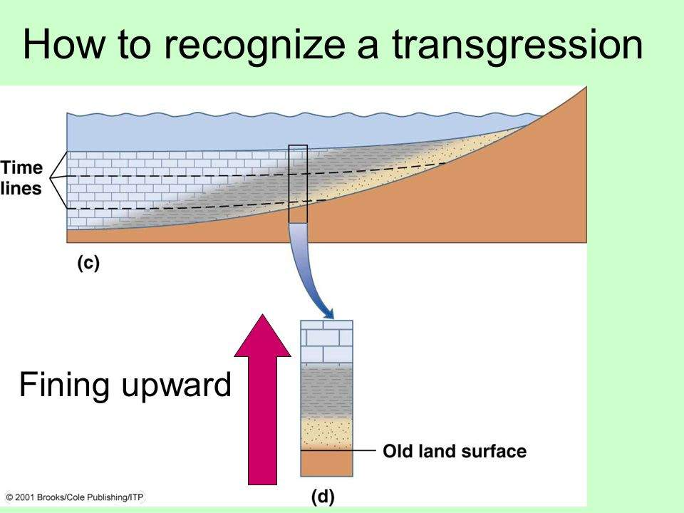
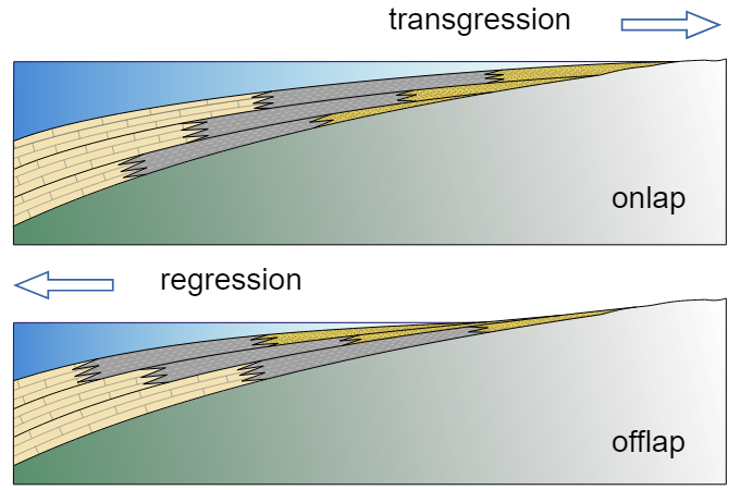
Sea-Level Changes (Eustatic and Relative) – Transgression (rising sea level) vs. Regression (falling sea level).
Tectonics – Uplift and subsidence affect sedimentation rates.
Climate – Influences erosion, transport, and sediment supply.
Sediment Source and Transport – Rivers, glaciers, wind, and marine currents deliver sediment.
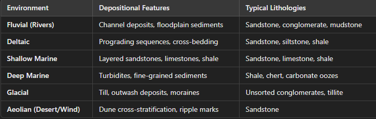
Common Depositional Environments & Their Sequences
Transgressive Sequences
Sea-Level Rise; Deepening upward sequence (shale → limestone → mudstone).
Regressive Sequences
Sea-Level Fall; Shallowing upward sequence (mudstone → limestone → sandstone).
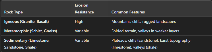
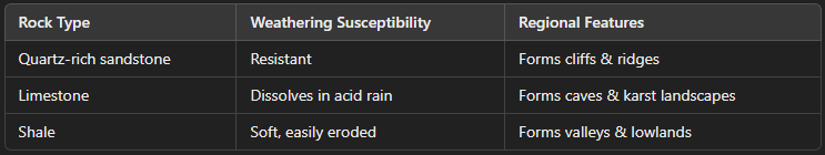
Erosion Patterns: Lithology and Erosion Resistance
Different rock types erode at different rates, creating distinctive landforms
Structural Elements and Erosion Patterns
Structural features influence how landscapes develop through erosion:
Structural Elements and Erosion Patterns: Folds & Faults
Anticlines → Erode into valleys due to weaker core rocks.
Synclines → Form ridges if resistant layers are present.
Faults → Create fault scarps, offset landforms, and fault-block mountains (e.g., Basin and Range Province).
Structural Elements and Erosion Patterns: Differential Erosion
Harder rocks form ridges & cliffs (sandstone, quartzite, basalt).
Softer rocks form valleys & lowlands (shale, limestone, mudstone)

Structural Elements and Erosion Patterns: Karst Topography (Limestone Dissolution)
Features: Sinkholes, caves, underground rivers.
Erosion Process: Chemical weathering (carbonic acid dissolves limestone).
Example: Mammoth Cave, Kentucky.
Structural Elements and Erosion Patterns: River Erosion & Sediment Transport
Meandering Rivers → Erode outer banks, deposit on inner banks.
Braided Rivers → High sediment load, shifting channels.
Structural Elements and Erosion Patterns: Coastal & Glacial Erosion
Wave-cut cliffs and sea stacks (coastal erosion of headlands).
Glacial U-Shaped Valleys and Moraines (glacial erosion and deposition).
Measurements of Structural Elements
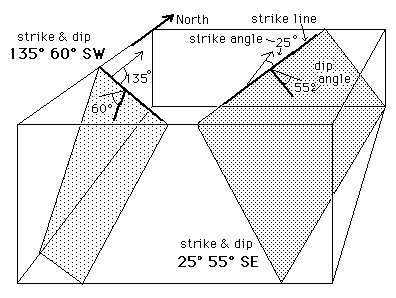
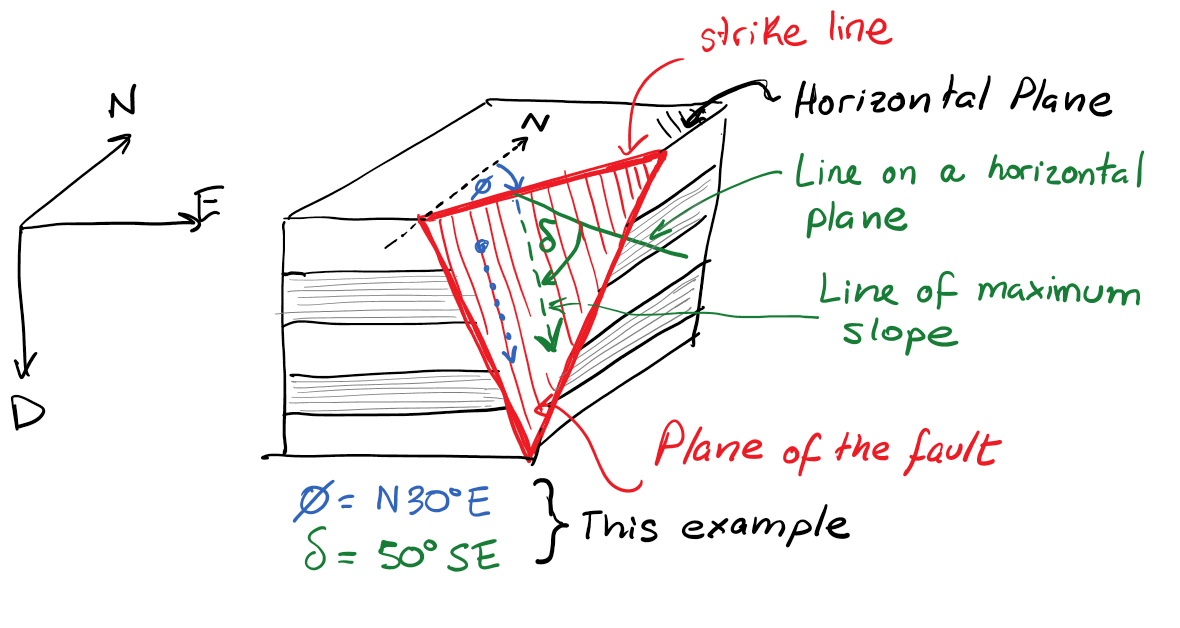
The measurement of structural elements like faults, folds, and bedding planes is essential in structural geology for understanding rock deformation, tectonic history, and resource exploration. The two primary measurements used to describe planar features in geology are strike and dip.
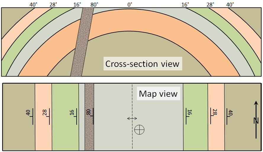
Measurements of Structural Elements: Strike
Definition: The compass direction of a horizontal line on an inclined plane. It represents the orientation of a rock layer, fault, or fold relative to North.
Measurement:
Measured in degrees relative to true North (0°–360°) using a compass.
Always recorded as the azimuth (e.g., 120° E of N) or a cardinal direction (e.g., N30°E).
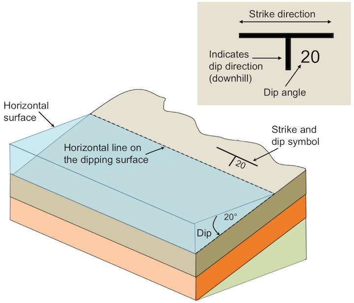
Measurements of Structural Elements: Dip
Definition: The angle of inclination between a rock layer and a horizontal surface. It indicates how steeply a plane slopes.
Measurement:
Measured in degrees (0°–90°) using a clinometer or geologic compass.
Dip Direction: The compass direction in which the rock layer slopes perpendicular to the strike (e.g., if the strike is N45°E, the dip direction could be SE or NW).
Measurements of Structural Elements: Notation Example
Strike and Dip: N45°E, 30°SE
Strike: N45°E (45 degrees east of north).
Dip: 30° to the southeast.
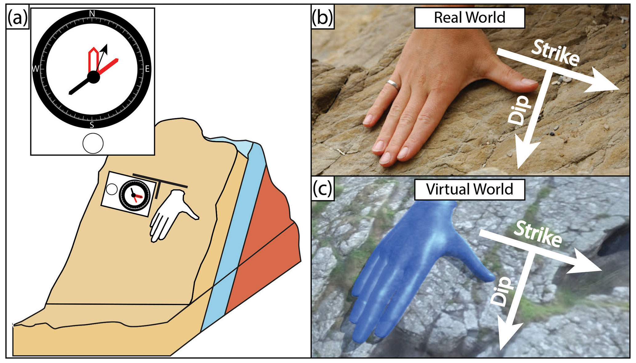
Measuring Structural Elements in the Field: Tools Used for Measurement
Brunton Compass or Geological Compass – Measures strike and dip.
Clinometer – Measures the dip angle.
GPS Device – Records precise location of measurements.

Measuring Structural Elements in the Field: Field Measurement Process (Strike)
Place the compass flat against the rock surface.
Rotate the compass until the bubble level is centered.
Read the compass bearing (this is the strike direction).
Measuring Structural Elements in the Field: Field Measurement Process (Dip)
Rotate the compass 90° perpendicular to the strike.
Tilt it along the slope of the rock layer.
Read the dip angle from the clinometer scale.
Measurements of Structural Elements: Measuring Fold Orientation
Fold Axis – The line connecting points of maximum curvature in a fold.
Axial Plane – The imaginary surface dividing a fold into two symmetrical halves.
Plunge – The angle between the fold axis and a horizontal plane.
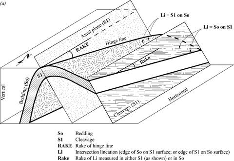
Measurements of Structural Elements: Measuring Fault Orientation
Fault Strike and Dip – Similar to bedding plane measurements.
Fault Slip – The direction and magnitude of movement along the fault plane.
Rake (Pitch) – The angle between the fault slip direction and the strike.
Importance of Structural Measurements
Tectonic Interpretation: Helps reconstruct past geological events (e.g., mountain building, faulting).
Resource Exploration: Essential in oil, gas, and mineral exploration.
Engineering and Geohazards: Used in assessing landslides, earthquakes, and construction stability.
Measuring strike and dip provides fundamental data for understanding geological structures. Accurate field measurements are critical in mapping rock formations, assessing stability, and predicting geological events.
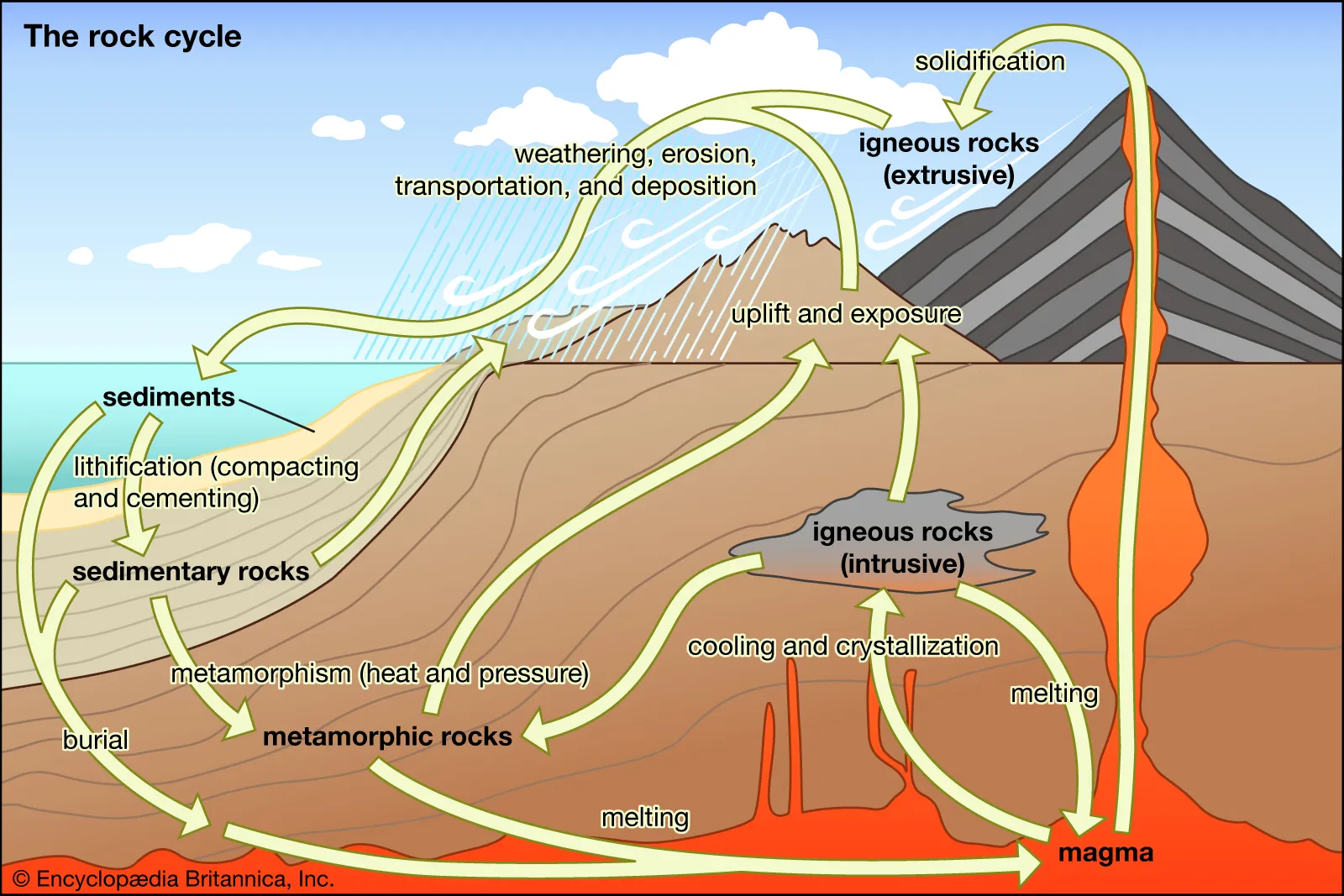
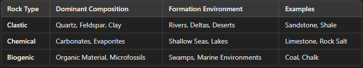
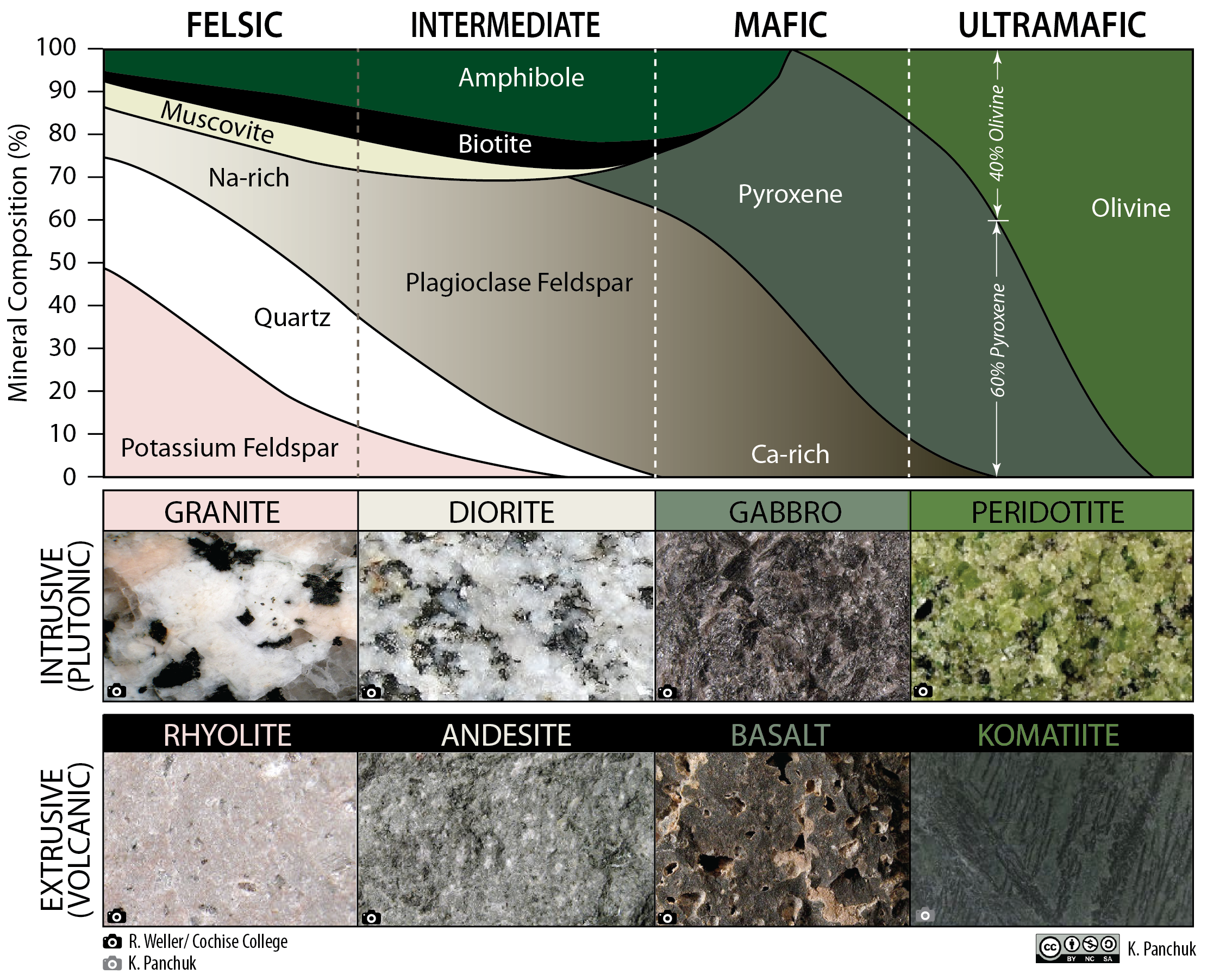
Rock formation and lithologies
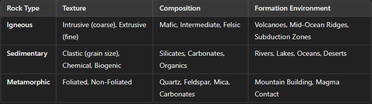
Rocks are classified into three main types based on their formation processes and environments. Each rock type has distinct formation methods, environments, and lithologies.
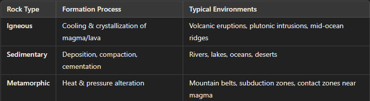
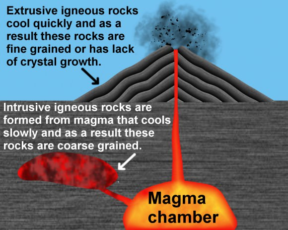
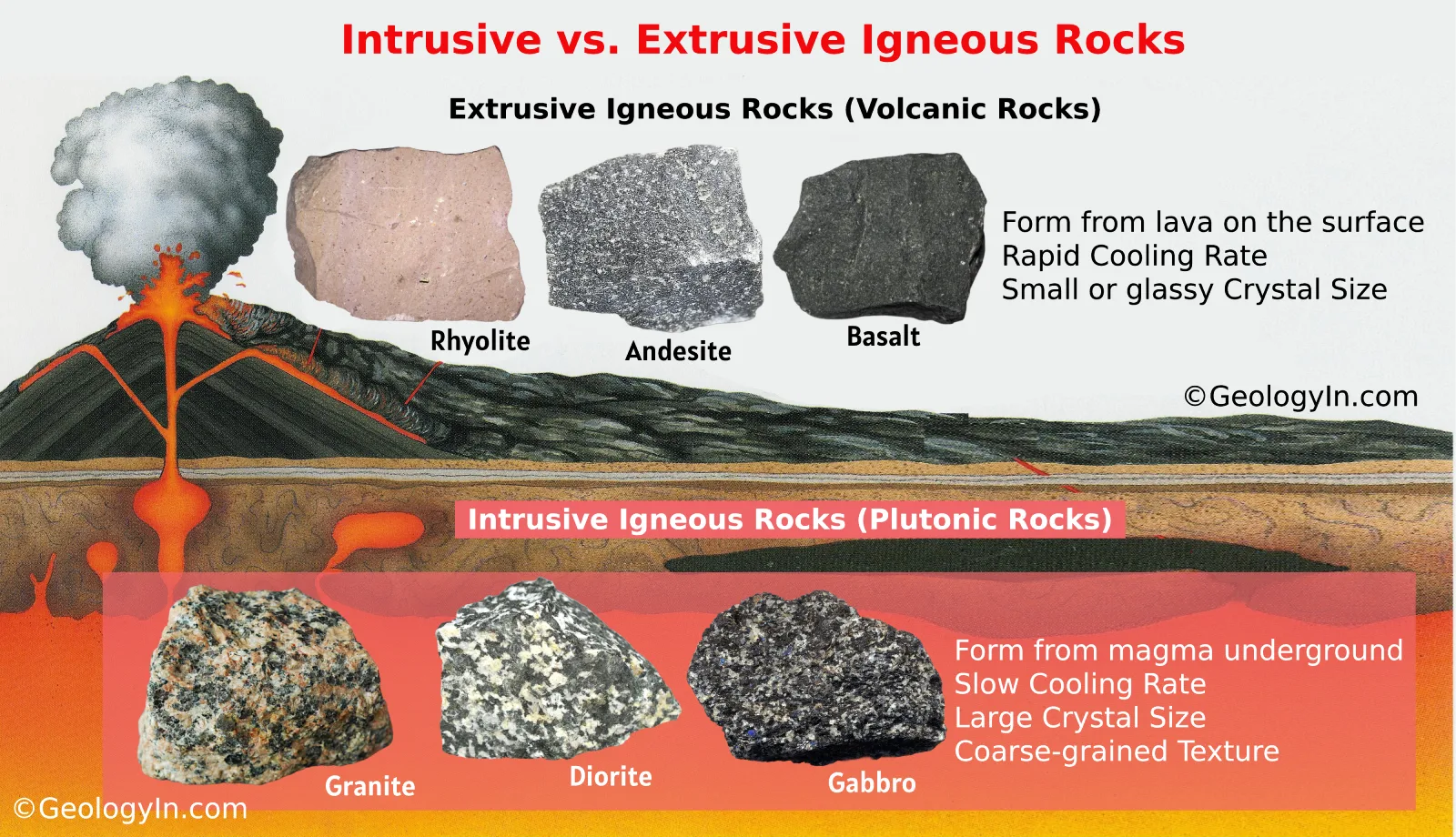
Igneous Rocks: Formation Process
Crystallization from Magma/Lava
Form when molten rock (magma or lava) cools and solidifies.
Cooling rate affects crystal size:
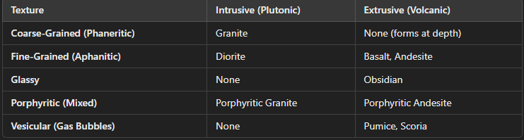
Slow cooling (intrusive/plutonic) → Large crystals (coarse-grained).
Fast cooling (extrusive/volcanic) → Small or no crystals (fine-grained, glassy).
Igneous Rocks: Types
Igneous Rocks: Environments
Intrusive Igneous Rocks → Cool slowly beneath the surface (e.g., granite in batholiths).
Extrusive Igneous Rocks → Cool rapidly at or near the surface (e.g., basalt flows, volcanic ash).
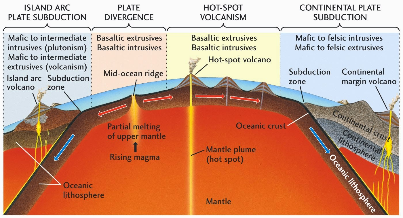
Mid-Ocean Ridges (Divergent Boundaries) → Basaltic magma forms oceanic crust.
Subduction Zones (Convergent Boundaries) → Andesitic and rhyolitic magmas form volcanic arcs.
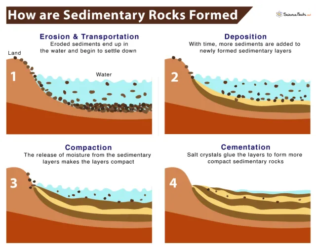
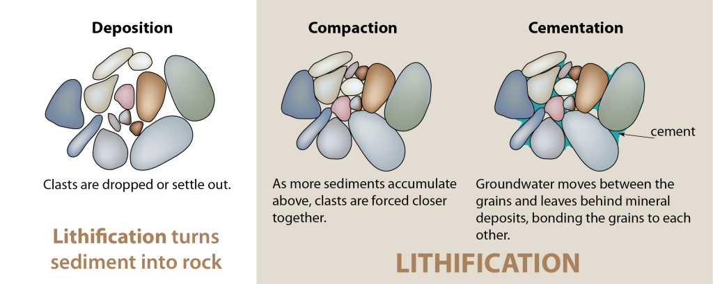
Sedimentary Rocks: Formation Process
Deposition and Lithification
Weathering & Erosion – Breakdown of pre-existing rocks.
Transport – Sediments are moved by water, wind, or ice.
Deposition – Sediments settle in basins (rivers, lakes, oceans).
Compaction & Cementation – Pressure and mineral precipitation lithify sediments into rock.
Sedimentary Rocks: Types
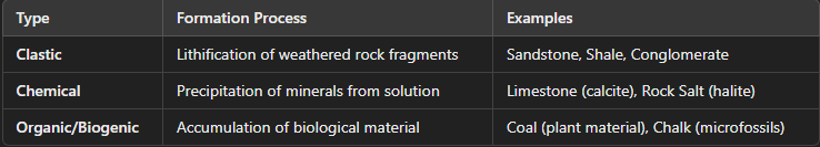
Sedimentary Rocks: Environments
Fluvial (Rivers) → Sandstone, siltstone.
Marine (Oceans) → Limestone, shale.
Deserts (Aeolian) → Cross-bedded sandstone.
Glacial → Tillite (unsorted sediments from glaciers).
Metamorphic Rocks: Formation Process
Alteration Under Heat & Pressure:
Form when pre-existing rocks (igneous, sedimentary, or metamorphic) undergo mineral and textural changes due to:
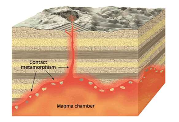
Heat (contact metamorphism) – Igneous intrusions cause localized recrystallization.
Pressure (regional metamorphism) – Tectonic forces cause large-scale rock transformation.
Hydrothermal Fluids – Hot fluids alter mineral composition.
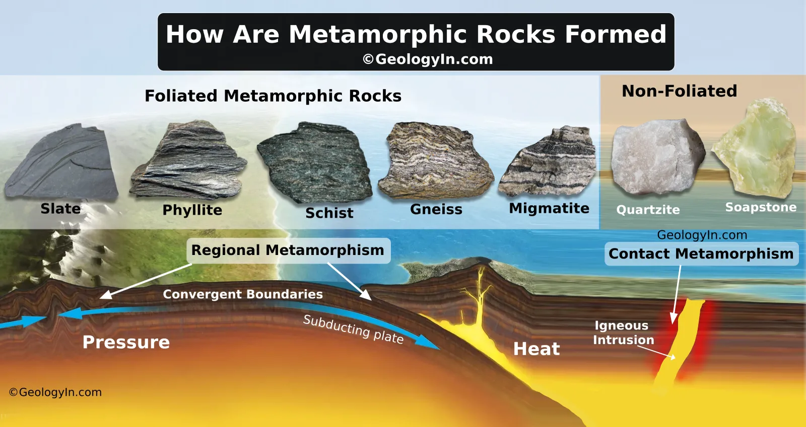
Metamorphic Rocks: Types
Metamorphic Rocks: Environments
Contact Metamorphism → Rocks heated by nearby magma (e.g., marble formation).
Regional Metamorphism → Large-scale deformation during mountain building (e.g., schist, gneiss).
Subduction Zones → High-pressure, low-temperature metamorphism (e.g., blueschist).
Relationships Between Texture, Composition, and Formation Environments of Rocks
The texture (grain size and arrangement), composition (mineral content), and formation environment of rocks are closely linked, particularly in igneous, sedimentary, and metamorphic rocks. Below is a breakdown of these relationships.
Igneous Rocks: Texture & Cooling Rate (Intrusive vs. Extrusive)
Intrusive (Plutonic) Rocks → Cool slowly beneath Earth's surface, forming coarse-grained (phaneritic) textures with large crystals.
Extrusive (Volcanic) Rocks → Cool quickly at or near the surface, forming fine-grained (aphanitic) or glassy textures.
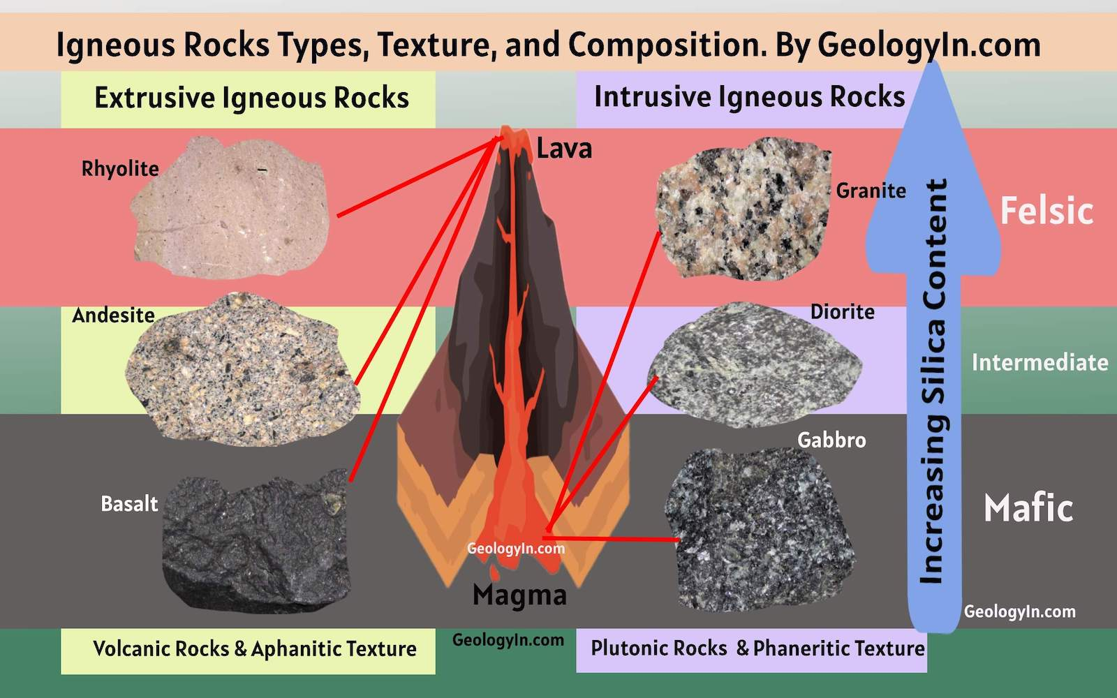
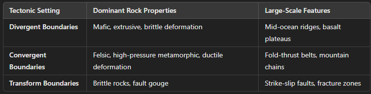
Igneous Rocks: Composition & Tectonic Setting (Mafic vs. Felsic)
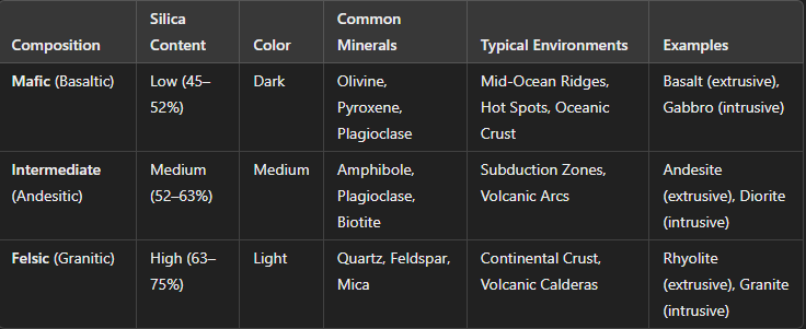
Igneous Rocks: Relationships
Mafic rocks (e.g., basalt) form at divergent boundaries (mid-ocean ridges, hotspots).
Intermediate rocks (e.g., andesite) form at convergent boundaries (subduction zones).
Felsic rocks (e.g., granite, rhyolite) form in continental crust settings (e.g., volcanic calderas, batholiths).
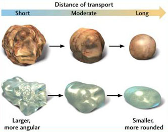
Sedimentary Rocks: Texture & Transport Distance
Coarse-grained (Conglomerate, Sandstone) → High-energy environments (rivers, beaches).
Fine-grained (Siltstone, Shale) → Low-energy environments (deep ocean, lakes).
Sedimentary Rocks: Composition & Depositional Setting
Sedimentary Rock: Relationships
Fast-moving water deposits coarse grains (sandstone, conglomerate).
Calm environments (deep ocean, lakes) deposit fine grains (shale, limestone).
Evaporites form in hot, dry climates (e.g., rock salt in desert lakes).
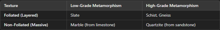
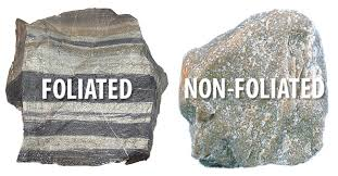
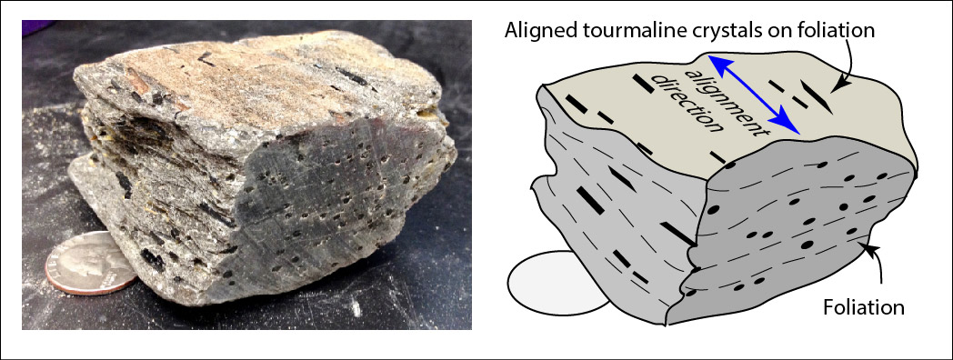
Metamorphic Rocks: Texture & Metamorphic Grade
Foliated (Layered) Rocks → Form under directed pressure (regional metamorphism).
Non-Foliated (Massive) Rocks → Form under high heat, low pressure (contact metamorphism).
Metamorphic Rocks: Composition & Parent Rock (Protolith)
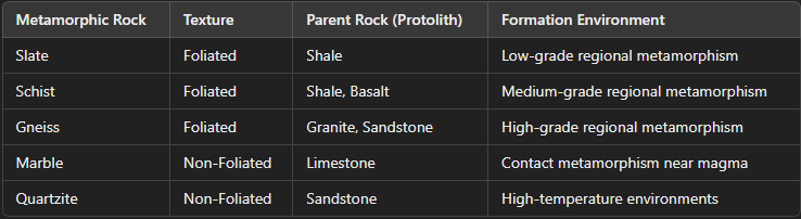
Metamorphic Rocks: Relationships
Foliated rocks form in mountain belts (regional metamorphism).
Non-foliated rocks form in magma intrusion zones (contact metamorphism).
How Texture, Composition, and Environment Relate
Understanding these relationships helps geologists reconstruct past environments, locate resources, and analyze Earth's geologic history.
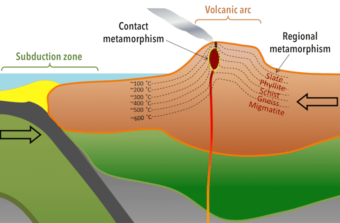
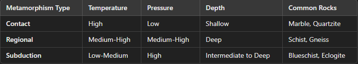
Types of Metamorphism: Contact Metamorphism (High Temperature, Low Pressure, Shallow Depths)
Cause: Heat from a nearby magma intrusion alters surrounding rock.
Pressure: Low (not associated with deep burial).
Depth: Shallow (upper crust, near plutons).
Temperature: High (~300–800°C).
Rock Texture: Non-foliated due to low pressure.
Common Rocks:
Marble (from limestone).
Quartzite (from sandstone).
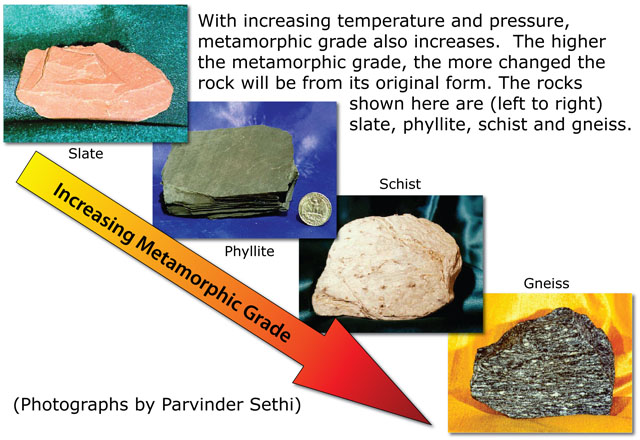
Types of Metamorphism: Regional Metamorphism (High Temperature & Pressure, Deep Burial)
Cause: Tectonic compression and deep burial (common in mountain belts).
Pressure: High (due to lithostatic stress).
Depth: Deep (10–40 km).
Temperature: Moderate to high (~300–800°C).
Rock Texture: Foliated due to directed pressure.
Common Rocks:
Slate → Schist → Gneiss (progression of shale under increasing metamorphism).
Types of Metamorphism: Subduction Zone Metamorphism (High Pressure, Low Temperature, Intermediate to Great Depths)
Cause: Rapid burial in subduction zones with minimal heating.
Pressure: Extremely high.
Depth: Intermediate to great depth (~20–80 km).
Temperature: Low (~100–500°C).
Rock Texture: Foliated due to compression.
Common Rocks:
Blueschist (forms in subduction zones).
Eclogite (forms at extreme depths).
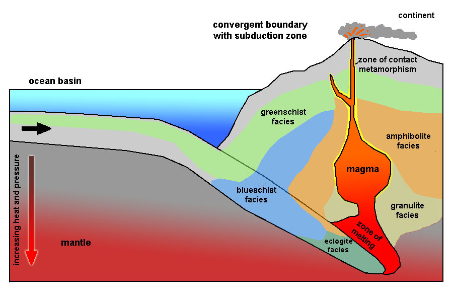
Metamorphic Facies: Temperature & Pressure Conditions
Metamorphic facies represent zones of mineral stability under specific temperature and pressure conditions.
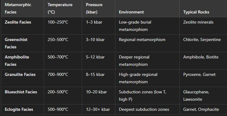
Summary of Temperature, Pressure, and Depth Relationships
Increasing temperature → Leads to mineral recrystallization (e.g., chlorite → biotite → garnet).
Increasing pressure → Leads to increased foliation (e.g., shale → slate → schist → gneiss).
Depth correlates with pressure → Deeper burial leads to higher-grade metamorphism (e.g., greenschist → amphibolite → granulite).
Understanding these relationships helps geologists interpret tectonic environments, reconstruct past geologic conditions, and locate valuable mineral deposits.
Connections Between Small-Scale Rock Properties and Macroscopic/Regional-Scale Features
The physical and chemical properties of rocks at the microscopic and mineralogical level directly influence their macroscopic and regional geological behavior. Understanding these connections helps geologists predict rock behavior in different tectonic, sedimentary, and metamorphic environments.
Small-Scale Physical & Chemical Properties → Large-Scale Geological Features
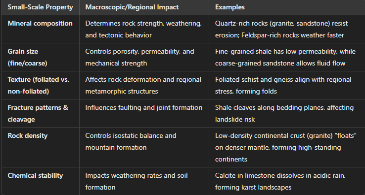
Igneous Rocks: Crystal Size & Composition → Tectonic & Erosional Features
Intrusive (coarse-grained) rocks → Form strong, erosion-resistant mountains and batholiths (e.g., Sierra Nevada).
Extrusive (fine-grained) rocks → Weather faster, forming volcanic plateaus and ash deposits (e.g., Columbia River Basalt).
Silica-rich (felsic) magmas → Form explosive volcanoes and stratovolcanoes (e.g., Andes).
Mafic magmas → Form fluid lava flows and shield volcanoes (e.g., Hawaii).
Sedimentary Rocks: Grain Size & Cementation → Basin Development & Resource Distribution
Porosity & Permeability control groundwater and petroleum reservoirs.
Sandstone → High porosity, good reservoirs.
Shale → Low permeability, forms cap rocks for oil/gas.
Bedding planes & lithification influence large-scale erosion and cliff formation (e.g., Grand Canyon).
Chemical sedimentary rocks (limestone, evaporites) form karst topography, caves, and sinkholes.
Metamorphic Rocks: Mineral Alignment & Pressure → Mountain Building & Deformation
Foliation (aligned minerals under pressure) influences how rocks break and fold in mountain belts.
High-grade metamorphism strengthens continental crust, forming deep crustal roots in orogenic belts (e.g., Himalayas).
Regional-Scale Impacts of Small-Scale Rock Properties: Tectonic Settings & Rock Properties
Regional-Scale Impacts of Small-Scale Rock Properties: Climate & Weathering Impact
Summary: From Small-Scale to Regional-Scale Features
Mineral composition → Affects erosion resistance, landscape evolution, and tectonic response.
Texture & structure → Determines faulting, folding, and fluid flow in basins.
Rock strength & density → Impacts mountain building and crustal stability.
Chemical stability → Shapes long-term surface processes and landform evolution.
Understanding these links helps in geological mapping, resource exploration, and hazard assessment (e.g., landslides, groundwater flow, earthquake-prone zones).
Interpretations and synthesis of geologic data (real and/or simulated)
…
Application of stratigraphic principles
Stratigraphic principles are fundamental concepts used in geology to interpret and understand the order, relative ages, and relationships of rock layers (strata). These principles are crucial for reconstructing Earth's history, identifying geological events, and correlating rock layers across regions. Here are the key stratigraphic principles: