AP HUG Unit 4 College Board
1/29
There's no tags or description
Looks like no tags are added yet.
Name | Mastery | Learn | Test | Matching | Spaced |
|---|
No study sessions yet.
30 Terms
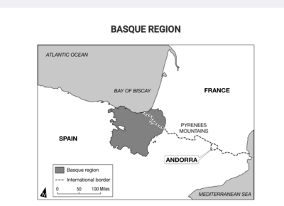
The area shown with the dark shading is best identified as
a) a functional region
b) a supranational organization
c) a regional free-trade zone
d) a stateless nation
e) a special economic zone
d) a stateless nation

Local and regional autonomous governments and a separatist militia group have been established within the Basque region shown on the map. How do these local and regional governments compare with the national governments of Spain and France?
a) Local and regional governments establish the foundations for new federal states within each of the larger independent states.
b) Local and regional governments stabilize local communities, aligning the communities with the objectives of the larger independent states.
c) Local and regional governments create the potential for conflict and act as a centrifugal force within the larger independent states.
d) Local and regional governments strengthen the unitary systems of government within the larger independent states.
e) Local and regional governments create a stronger geopolitical region and act as a centripetal force within the larger independent states.
c) Local and regional governments create the potential for conflict and act as a centrifugal force within the larger independent states.

South Sudan gained its independence in 2011, reshaping the boundaries of Sudan. Which of the following best explains the implications of the shaded area shown on the map in Darfur?
a) Like South Sudan, Darfur has gained its independence and is now a sovereign nation-state.
b) Devolution is likely in Sudan as the country is a multinational state with no distinct majority group.
c) Darfur is a region of ethnic difference and political instability where devolution is likely.
d) Devolution is likely in South Sudan as it is landlocked country with no distinct majority group.
e) Sudan has a large population with a distinct majority group and further devolution is unlikely.
c) Darfur is a region of ethnic difference and political instability where devolution is likely.

The map shows the world's newest country, South Sudan, formerly part of Sudan, and the Islamic region of Darfur, which is seeking some level of political autonomy within Sudan. In comparison with the east-west divide between Darfur and the rest of Sudan, which of the following centrifugal forces led South Sudan to seek independence from Sudan?
a) South Sudan wanted a larger share of productive oil resources located in Ethiopia and Eritrea.
b) Sudan filed for bankruptcy in the International Court, whereas South Sudan grew wealthy from international trade.
c) Sudan and South Sudan are home to one homogeneous nation in terms of religion and ethnicity.
d) Sudan established a military presence in the region of South Sudan following a referendum vote, prompting a conflict.
e) Sudan and South Sudan's border is a transition zone between Africa's Islamic northern region and the Christian and animist regions of sub-Saharan Africa.
e) Sudan and South Sudan's border is a transition zone between Africa's Islamic northern region and the Christian and animist regions of sub-Saharan Africa.
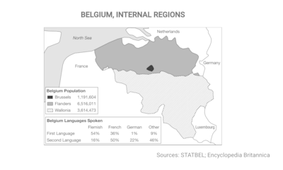
In 1993 Belgium divided much of its internal government into three semiautonomous regions. Based on the data shown in the map, which of the following best explains the political divisions within Belgium?
a) Each region is separated from the others by physical barriers that impede communication and trade among regions.
b) Regions are delineated based upon the percent of population that speaks French as a first or second language.
c) Divisions are based on language, providing ethnic groups some self-governance and preserving Belgium as a federal state.
d) The population is evenly divided between French speakers and Flemish speakers.
e) Divisions are based on ethnicity, recognizing the country's linguistic diversity and preserving Belgium as a multistate nation.
c) Divisions are based on language, providing ethnic groups some self-governance and preserving Belgium as a federal state.

Based on the map data, which of the following best explains a factor that has led to ethnic separatism in Belgium?
a) A multilingual society has emerged, with several languages being spoken by the overall population.
b) The populations of the three regions are not evenly balanced or equally distributed.
c) Many who speak French as their first language also speak Flemish, but few people who speak Flemish as their first language also speak French.
d) Many who speak Flemish as their first language also speak French, but few people who speak French as their first language also speak Flemish.
e) A multinational state has developed into a multicultural society where language and ethnicity are of little importance to personal identity.
d) Many who speak Flemish as their first language also speak French, but few people who speak French as their first language also speak Flemish.
Some communities along the internal border between Flanders and Wallonia are required by Belgian federal law to have bilingual local governments, with road signs and government publications in Flemish and French. Some nearby communities refuse to permit a census of language users because they are concerned that the results will trigger federal requirements for a bilingual local government.
Which of the following geographic concepts best explains the efforts to preserve a single official language in such communities?
a) Choke points, because local communities are defining themselves as exclusively Flemish or French.
b) Protectionism, because these communities exclude services and international trade conducted in different languages.
c) Shatterbelts, because linguistic divisions are the result of different political-economic systems at the national and international scales.
d) Relict boundaries, because cultural divisions have become irrelevant in these local communities.
e) Territoriality, because communities are expressing power and political control over the landscape.
e) Territoriality, because communities are expressing power and political control over the landscape.
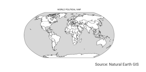
8.Which of the following identifies the primary building blocks of the world political map shown?
a) Nations
b) Multinational states
c) Independent states
d) Autonomous regions
e) Multistate nations
Independent states
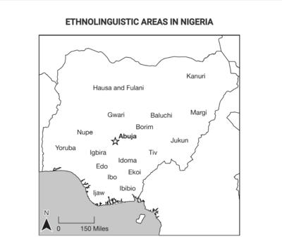
Based on the information shown in the map, Nigeria can be identified as a
a) multinational state
b) nation-state
c) colonial power
d) choke point
e) multistate nation
a) multinational state
FALKLAND ISLANDS
United Kingdom
Name: Falkland Islands
Distance to the United Kingdom: 6,250 nautical miles
Dates of Control: 1765-1767, 1771-1774, 1833-1982, 1982 to present
Argentina
Name: Islas Malvinas
Distance to Argentina: 182 nautical miles
Dates of Control: 1770-1881 (as Spanish Viceroyalty of Río de la Plata), 1829-1831 (Argentina, onward), 1832-1833, three months in 1982
The Falkland Islands War took place in 1982 between Argentina and Great Britain, when Argentina's military invaded the small British overseas territory in the South Atlantic Ocean. British forces reclaimed the islands after a short war.
Using the information shown, which of the following geographic principles explains the conflict in the Falkland Islands?
a) Irredentism and the desire to form a nation-state
b) Overlapping claims of sovereignty
c) A political independence movement against the ruling colonial power
d) The establishment of territorial seas
e) Ethnic and religious differences that led to the devolution of a state
b) Overlapping claims of sovereignty
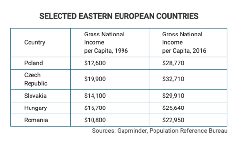
Which of the following best explains why the countries shown in the table experienced increases in economic productivity?
a) Irredentism in former communist states and political divisions among ethnic and religious groups
b) Dissolving of the Warsaw Pact and economic alliances made with former republics of the Soviet Union
c) The rise of Russia as an emerging world economy and the economic impacts on its nearby trading partners
d) Independence following the end of the Cold War and admission to the North American Treaty Organization (NATO)
e) Self-determination following decline of communism and admission as member states to the European Union
e) Self-determination following decline of communism and admission as member states to the European Union
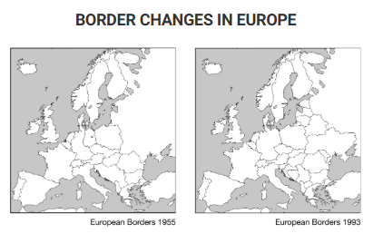
Despite the rise of supranationalism in Europe from 1955 to 1993, the number of independent political entities increased. Based on a comparison of the two maps shown, which of the following processes occurred in Europe during that time period?
a) Devolution of large states into smaller nation-states
b) Cultural globalization reducing ethnic differences
c) Annexation of smaller states into larger states
d) Redistricting the internal boundaries of federal states
e) Territorial expansion of imperial states
a) Devolution of large states into smaller nation-states
The geopolitical setting of which of the following countries can be explained by its membership in the Warsaw Pact during the Cold War and its location along the European shatterbelt?
a) France
b) Bulgaria
c) Italy
d) Switzerland
e) Belgium
b) Bulgaria
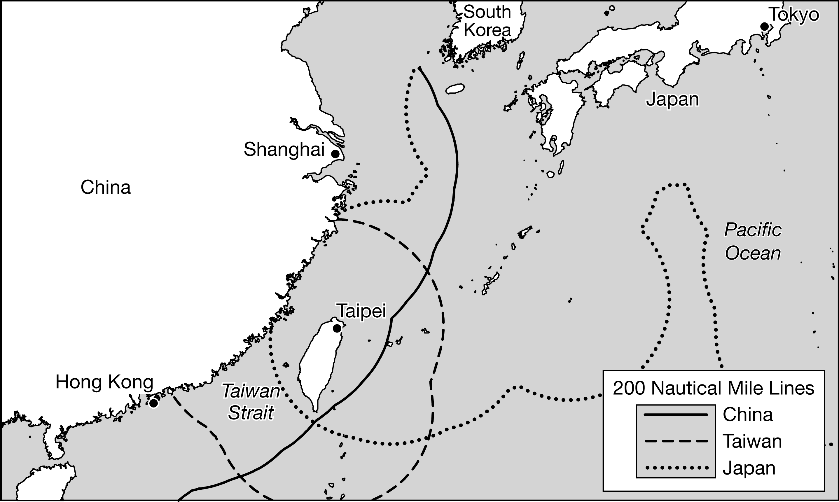
The map shows the Taiwan Strait. Which of the following best explains the global geopolitical significance of the Taiwan Strait?
a) The Taiwan Strait is a cultural boundary that separates populations of Chinese people who speak different languages.
b) The Taiwan Strait serves as a major international shipping route that serves large economies, such as South Korea, Japan, and the United States.
c) The Taiwan Strait is a militarily strategic chokepoint that China and Taiwan claim as territory.
d) The Taiwan Strait creates an obstacle to trade between Taiwan and China and hinders the region's economy.
e) The Taiwan Strait is a remnant of the colonial relationship between China, Taiwan, and European countries.
c) The Taiwan Strait is a militarily strategic chokepoint that China and Taiwan claim as territory.
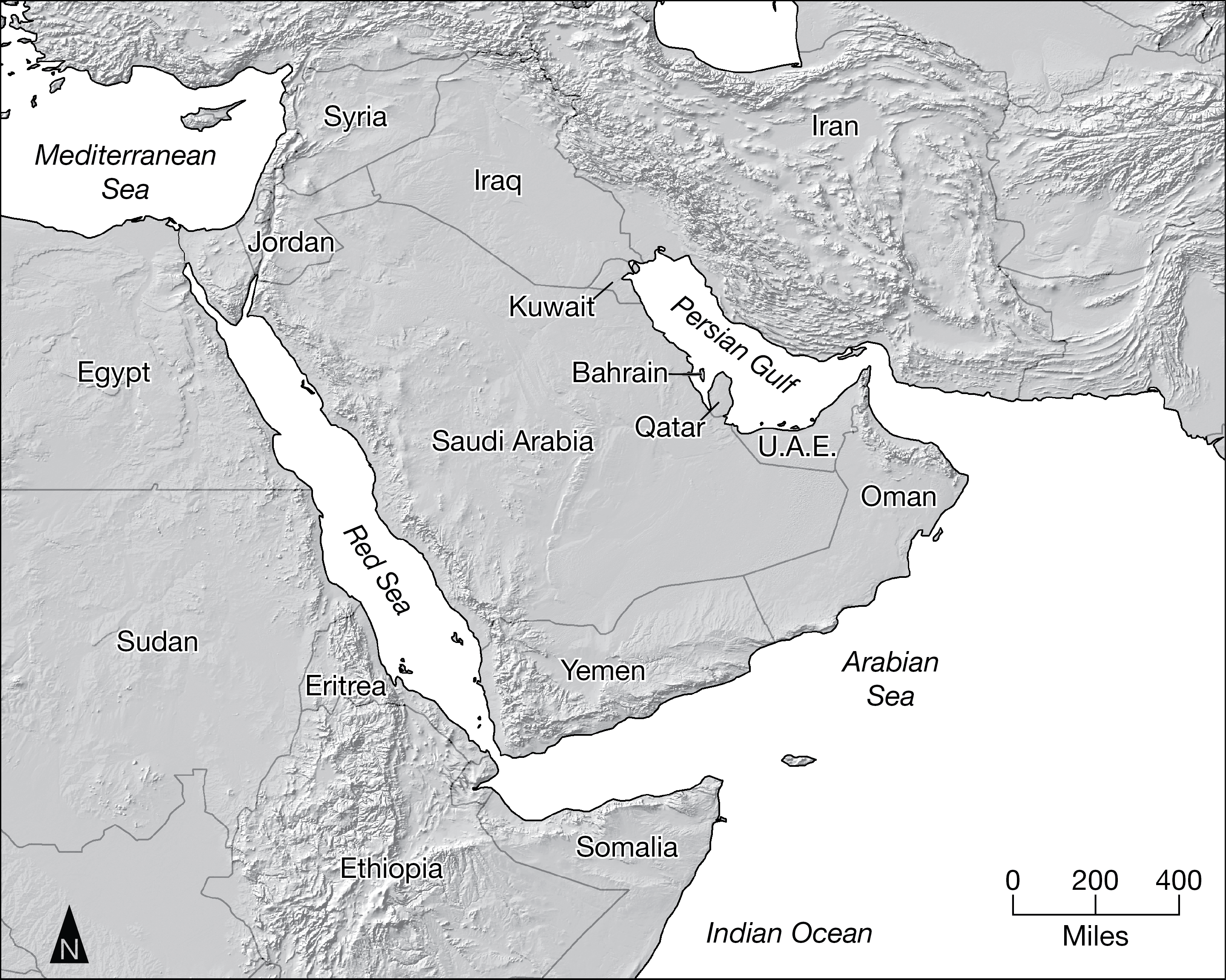
Which of the following statements is helpful in explaining why Iran and the United Arab Emirates (UAE) are able to assert some control over the export of oil from the Persian Gulf oil-production region?
a) Both Iran and the UAE have coastlines along the Arabian Sea and thus have the easiest access to global markets.
b) Their location along the choke point of the Strait of Hormuz allows them to influence ship movement into and out of the Persian Gulf.
c) Both Iran and the UAE border the Persian Gulf, a location of large oil deposits, and thus have the greatest offshore oil claims.
d) Their close proximity to the large Asian markets of Japan and China give them an economic advantage over other OPEC countries.
e) As the founding members of OPEC, they hold the largest influence over OPEC policies and decisions.
b) Their location along the choke point of the Strait of Hormuz allows them to influence ship movement into and out of the Persian Gulf.
The political boundaries of North Africa and the Middle East can best be described as the product of which of the following processes?
a) Devolution
b) Imperialism
c) Self determination
d) Democratization
e) Super nationalism
b) Imperialism
Which of the following types of political boundaries best describe the border between the United States and Canada?
a) Relict
b) Militarized
c) Geometric
d) Open
e) Gerrymandered
In locations such as the Caribbean Sea, international borders between island states are determined by the United Nations Convention on the Law of the Sea. These maritime boundaries can best be described as
a) Relict borders
b) Superimposed borders
c) Subsequent borders
d) Antecedent borders
e) Consequent borders
b) Superimposed borders
Which of the following best explains the primary function of international political boundaries?
a) Boundaries define national identity and encourage a patriotism that make local cultures recognizable.
b) Boundaries limit international trade and improve regional economies within the country.
c) Boundaries limit sovereignty and determine the extent of a state's power within the global political system.
d) Boundaries promote international relations between neighboring states and encourage peace.
e) Boundaries resolve disputes over water resources and determine which countries have the right to extract water.
c) Boundaries limit sovereignty and determine the extent of a state's power within the global political system.
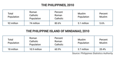
The cultural composition of the Philippines and its constituent islands affects the political stability of the country. Which of the following patterns is best explained by the data in the tables?
a) An even dispersal of Muslims around the country, leading to assimilation
b) An even dispersal of Muslims around the country, leading to ethnic separatism
c) An even dispersal of Muslims around the country, leading to irredentism
d) A concentration of the majority of the country's Muslim population on one island, leading to assimilation
e) A concentration of the majority of the country's Muslim population on one island, leading to ethnic separatism
e) A concentration of the majority of the country's Muslim population on one island, leading to ethnic separatism
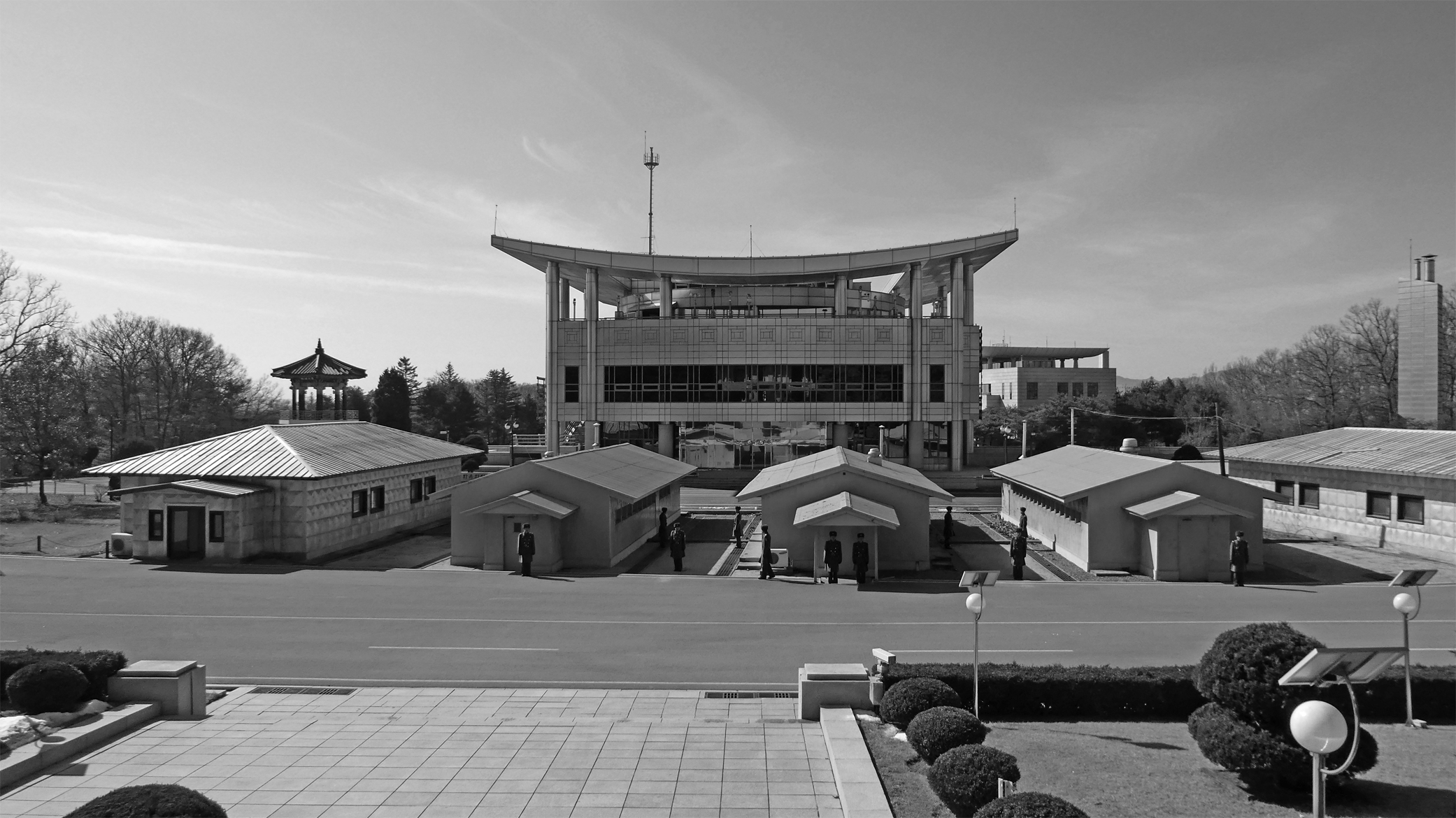
The photograph shows guards at the Truce Village of Panmunjom within the demilitarized zone (DMZ) that divides the Korea Peninsula into North Korea and South Korea. The DMZ border was agreed upon as part of Korean Armistice Agreement at the end of the Korean War in 1953. Which of the following best explains the effect of the DMZ on the Korean Peninsula as a culture region?
a) North and South Korea are divided into two distinct nations that have separate cultures and heritages.
b) North and South Korea constitute one sovereign state that have two separate regional governments.
c) The Korean people are divided into a multistate nation that has a common heritage and ethnicity.
d) North Korea is a semiautonomous region of South Korea that has self-governance over its military.
e) North Korea is a stateless nation within South Korea that does not have a representative government.
c) The Korean people are divided into a multistate nation that has a common heritage and ethnicity.
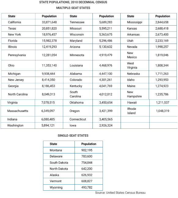
The population counts shown in the table would most likely be used for which of the following purposes?
a) The reapportionment and redistricting of the United States Senate that occurs every 10 years
b) The reapportionment and redistricting of the of the United States House of Representatives that occurs every 10 years
c) The redistricting of the electoral college that occurs every 10 years
d) The reapportionment of the United States Congress when members of Congress change their political party affiliation
e) The reapportionment of the United States Congress when members of Congress move from one state to another
b) The reapportionment and redistricting of the of the United States House of Representatives that occurs every 10 years
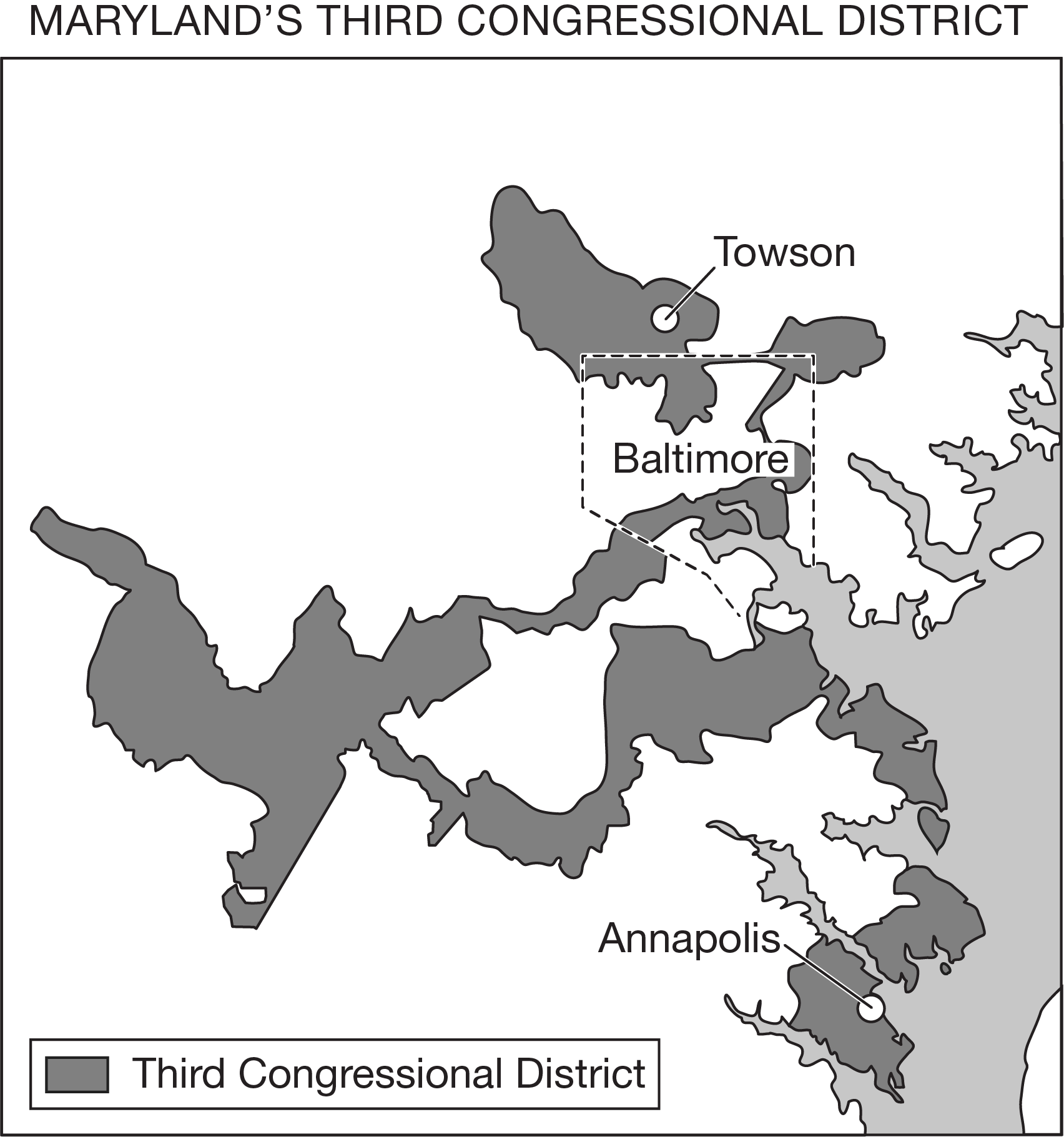
Residents of Maryland’s Third District could legally challenge the redistricting of the area shown on the map because they identify it as being
a) A sovereign boundary created to promote the establishment of an independent state
b) Part of the federal state, which grants proportional representation in the United States House of Representatives
c) A maritime boundary that extends out into the waters of the Chesapeake Bay
d) a gerrymandered boundary that guarantees a political party’s seat within the United States House of Representatives
e) part of an autonomous region that limits the State of Maryland’s control over the district.
d) a gerrymandered boundary that guarantees a political party’s seat within the United States House of Representatives
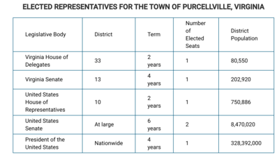
Which of the following identifies the scale of governance that would be most affected by an individual local voter in Purcellville?
a) Virginia House of Delegates
b) Virginia Senate
c) United States House of Representatives
d) United States Senate
e) President of the United States
a) Virginia House of Delegates
Which of the following describes a typical spatial relationship between federal and unitary states?
a) Federal states tend to be smaller than unitary states.
b) Unitary states tend to be smaller than federal states.
c) Unitary states tend to be more densely populated than federal states.
d) Federal states tend to have a more urban population than unitary states.
e) Federal states are more likely to be landlocked than unitary states.
b) Unitary states tend to be smaller than federal states.
Which of the following features is a common characteristic of unitary states?
a) A primarily agricultural society
b) Dispersed power centers
c) Specific physical geographical features
d) A weak hold on power over territory
e) A strong central capital
e) A strong central capital
Which of the following describes a unitary state?
a) An ethnically homogeneous state where all citizens identify as members of the same nation
b) A state in which government decisions are made at the national level and applied uniformly across the state
c) A state in which one leader and one party have complete political, economic, and social control
d) A state in which subunits are granted independent constitutional authority
e) A state that is geographically contiguous with no fragmented land areas separated from the rest of the state
b) A state in which government decisions are made at the national level and applied uniformly across the state
Which of the following statements accurately compares the processes of devolution and supranationalism that challenge the sovereignty of Canada?
a) Centripetal forces are present in Quebec, whereas the free-trade agreement between the United States, Canada, and Mexico is a centrifugal force on a national level.
b) Centripetal forces are present in Quebec, whereas the free-trade agreement between the United States, Canada, and Mexico challenges the Canadian government’s independence on a national level.
c) Centrifugal forces are present in Quebec, whereas the free-trade agreement between the United States, Canada, and Mexico challenges the Canadian government’s independence on a national level.
d) Centripetal forces are present in Quebec, whereas the free-trade agreement between the United States, Canada, and Mexico is a governance issue at the provincial scale.
e) Centrifugal forces are present in Quebec, whereas the free-trade agreement between the United States, Canada, and Mexico is a governance issue at the provincial scale.
c) Centrifugal forces are present in Quebec, whereas the free-trade agreement between the United States, Canada, and Mexico challenges the Canadian government’s independence on a national level.
Which of the following technological examples is best used to compare the effects of local-scale and global-scale political challenges to state sovereignty?
a) Laptop computers used by aid agencies in nation-building
b) Social media Web sites supporting supranational organizations
c) Centrifugal forces are present in Quebec, whereas the free-trade agreement between the United States, Canada, and Mexico challenges the Canadian government’s independence on a national level.
d) Cell phone use weakening corrupt governments
e) Satellite image analysis contributing to devolution
d) Cell phone use weakening corrupt governments
Which of the following is the best example of centrifugal forces operating at the local scale as compared to the national or international scale?
a) A failed state
b) Increased cultural cohesion
c) Increased social equity
d) A stateless nation
e) Uneven development
e) Uneven development