Fluvial Landscapes
1/37
There's no tags or description
Looks like no tags are added yet.
Name | Mastery | Learn | Test | Matching | Spaced | Call with Kai |
|---|
No study sessions yet.
38 Terms
Denudation
The wearing down of the landscape. Rivers are key agents of denudation, linking “source” areas to “sinks”, they are the "arteries of the landscape"
Each year, how much sediment do rivers globally deliver
About 20 billion tonnes of sediment annually
How diverse are these riparian zones
Riparian zones comprise <1% of the land area in temperate regions, but support >80% of the species
Drainage Basin
A fundamental fluvial geomorphic unit, the area of land where water will move down, defined by topography and moved via gravity, towards the ocean. Basin scale characteristics control the inputs and outputs of water and sediment to the river network. Sediment flux in a river basin is a product of:
• Rates of sediment production (supply)
• Rates of sediment movement (transport)
• Connectivity between supplies and transport components of the landscape
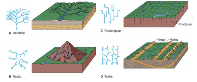
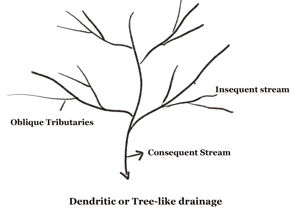
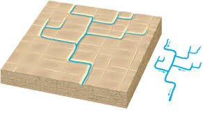
Dendritic Drainage Pattern
Are most common where rocks or sediments are flat-lying with uniform rock types that offer equal resistance to erosion (homogenous rock) meaning there is no apparent control over the direction the tributaries take.
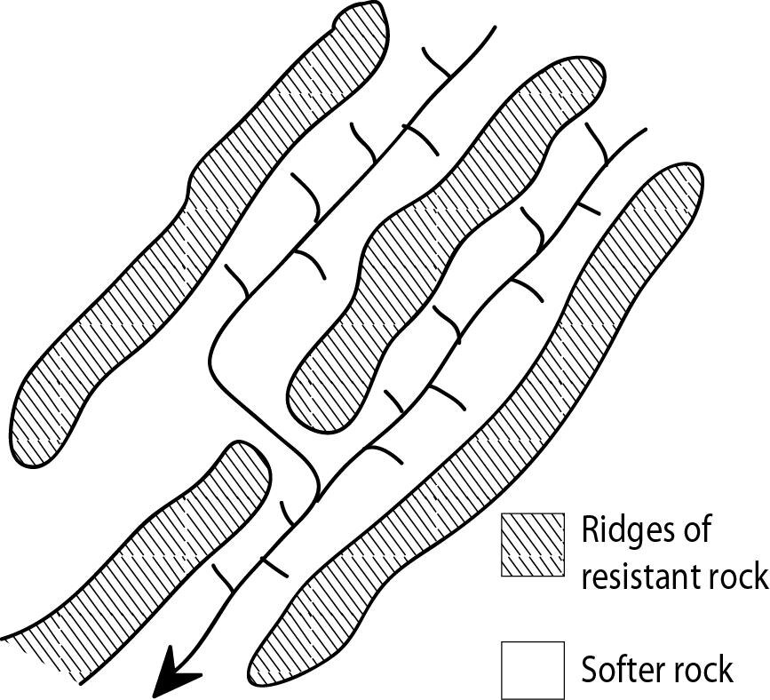
Trellised Drainage Pattern
If the rocks are not homogeneous and are made of an alternate layer of hard and soft rocks. So the streams join the main river by eroding the soft rocks at a right angle
Rectangular Drainage Pattern
When streams join the main river through the space between the hard rocks without any erosion at a right angle, then it is called rectangular drainage. In this, the tributaries flow through faults, joints, or fractures in the bedrock that are at right angles to each other, often in areas of uniform rock resistance
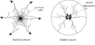
Radial and Centripetal Drainage Pattern
Radial Patterns occur when the streams move in an outward direction from a high central point, they form a radial pattern. It is formed when a stream of water flows in different directions starting from a centre point (usually a dome-like structure or a peak).
Centripetal patterns are almost identical to a radial drainage system. The only difference is that in radial drainage water flows out while in centripetal drainage water flows to a centre point, into a depression or basin in the land.
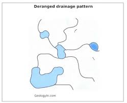
Deranged Drainage Pattern
It occurs in drainage basins where there is no consistent pattern of rivers and lakes. The region in which this pattern occurs is usually geologically disrupted. It can be found in areas with low relief, low slopes, and large sediment loads
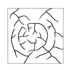
Annular Drainage Pattern
When streams follow a rough concentric or circular path along a belt of weak rock and form a ring-like pattern, it is called an annular drainage pattern. It can be seen in the regions where streams flow through the maturely dissected basin or structural dome where the sedimentary strata vary in hardness.
Discordant Drainage Pattern
When a drainage pattern is formed which does not match the topography and geology of the region, it is called a discordant drainage pattern. It is further categorised as:
-Antecedent – Both vertical erosion and upliftment of land occur with the same force.
-Superimposed – It happens in two stages. First, a drainage system appears on the surface which is composed of young rocks. The denudation process of river removes the upper surface and continues to erode it and finally reaches the old rocks.
-Ante-position – When both antecedent and superimposed drainage combine, it is called an ante-position drainage pattern.
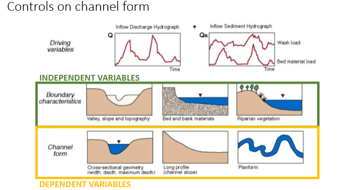
What are the driving variables on channel form controls
-Amount of Water
-Wash load
-Bed Material load
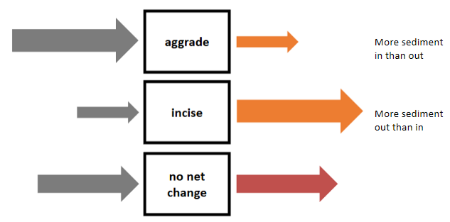
Sediment Budgets
A budget is simply a comparison of a quantity in relative to a quantity out. Budgets consider where does sediment come from (SOURCE) and go (SINKS), does sediment get stored somewhere in the system pathway (STORAGE or RESIDENCE TIME), sediment budgets (conservation of mass) as they are a fundamental concept in geomorphology and if you know the balance between what sediment goes in vs what goes out, then you can predict system response
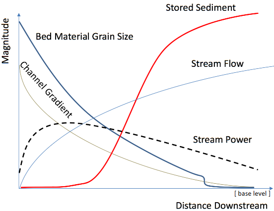
What occurs as you increase distance downstream
As you go down a river, the slope decreases (lower elevation), channel flow increases as the catchment area grows, the grain size turns from course to fine as it gets eroded as it flows as well as larger sediment being deposited upstream, and stream power increases initially and then gradually decreases.
We can see this in the relatively undisturbed Tagliamento river where it changes from a steep mountain gully, from braided rivers to a meandering stream. Vegetation plays a role, making banks more resistant to erosion.
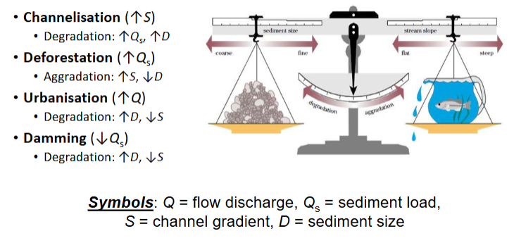
Lane’s Balance Equation
Qs.D50∝Qw.S
Q= flow discharge
Qs= sediment load
S= channel gradient
D= sediment size
What are sediment flux dynamics
They are key measure of geomorphic work and key components of landscape evolution. Creates valley, floodplain and channel morphology and maintains physical habitats and associated ecology
What occurs if there’s too much sediment transport
-Create hydraulically inefficient channels.
-Require expensive maintenance
-Have negative impact on in-stream biota
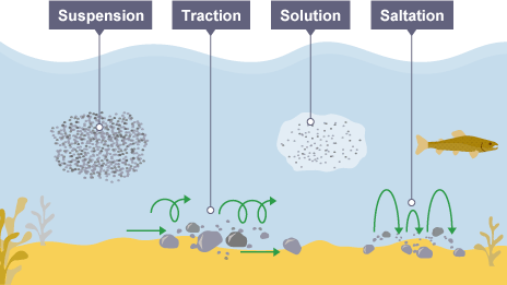
Types of sediment transport
-Traction - large, heavy pebbles are rolled along the river bed. This is most common near the source of a river, as here the load is larger.
-Saltation - pebbles are bounced along the river bed, most commonly near the source. Bedload like gravel or sand is sediment that moves along in un-permanent contract with the bed that is larger and heavier.
-Suspension - lighter sediment is suspended (carried) within the water, most commonly near the mouth of the river. Suspended particles such as silts and clay are the finest particles.
-Solution - the transport of dissolved chemicals. This varies along the river depending on the presence of soluble rocks. Dissolved load are minerals that have dissolved in the water, held in the water column.
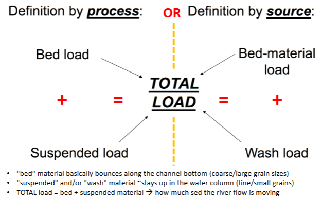
How would we show total load of sediment used
Bedload plus suspended load shows the total load of sediment used.
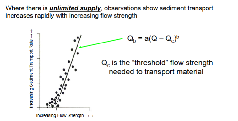
Threshold of Mobility
Above a critical threshold of mobility, there is a uniform positive corelation between flow strength and sediment transport rate.
However, this cannot reflect reality as there is not always unlimited supply as well as many natural factors in play.
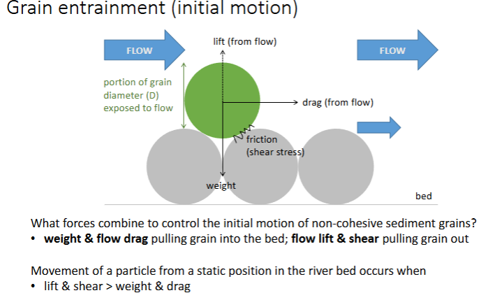
Grain Entrainment
For any particle on a river bed, there are several forces acting against them, e.g. gravitational weight, friction between sediments, and the flow trying to move it through lift, drag, and exposed area to the flow.
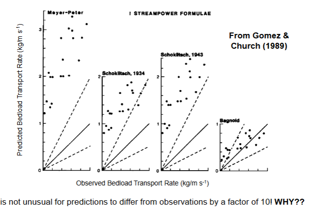
Predicted versus Observed Transport Rate
The predicted transport rate tends to be around 3x more than the observed, when following the initial equation, showing the observations are far from accurate. This is not ideal as building river management requires a knowledge of its transportation of sediment.
What are the sediment transport controls
-Sediment size and arrangement on the bed (Resistance to movement).
-Force exerted by water flowing over the bed.
-Upstream supply of sediment.
-Connectivity to upstream sediment supply
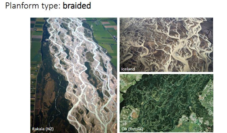
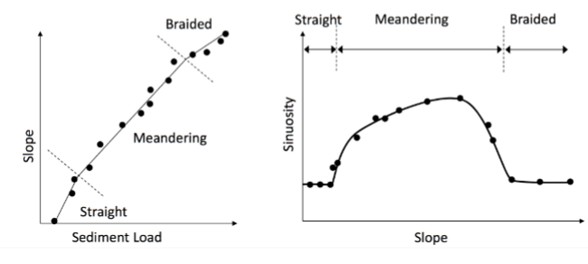
Braided Rivers
Braided rivers are many channels that cut across each other, these channels are separated by active gravel sediment (temporary bars)
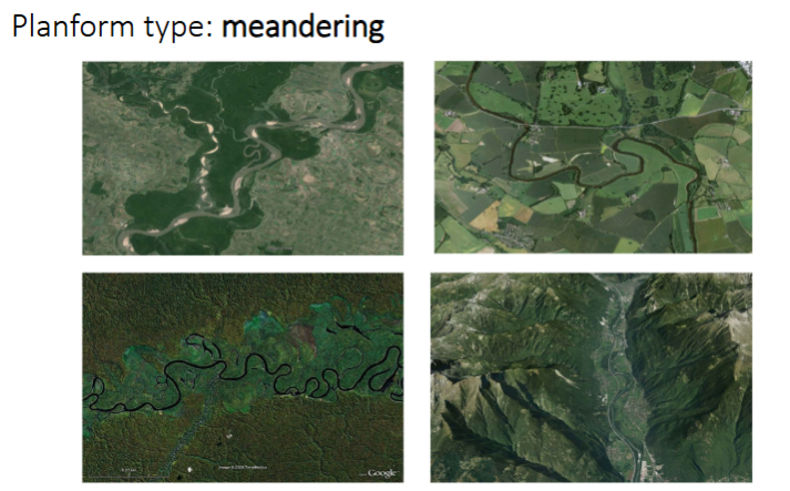
Meandering Rivers
One distinct meandering river channel that spreads along the floodplain. Created by continuous erosion on the outer bank and deposition on the inner bank, causing the river to migrate across its floodplain over time
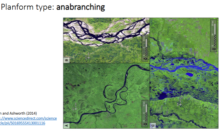
Anabranching Rivers
Channels that split off and re-join onto the main river. It's different to braided as it is divided by vegetated islands
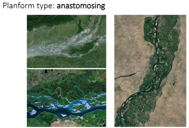
Anatomosing Rivers
Rivers that have large amounts of vegetation involved, growing over depositional areas and creating more fixed river divisions.
Flume Experiments
Indicate that the straight-meandering-braided planform transition is associated with increased slope (energy) and increased sediment supply
Socio-economic Importance of rivers
-40% of global populations live on the floodplains of the 30 largest rivers, many of these are poor who are highly exposed to natural disasters (flooding, erosion)
-Distinct morphological characteristics, processes and attributes
-They are so large they can cross through climate zones
-Have distinctive and difficult management challenges
-Affected by regional and global change
-Transnational character
-Recipe for poor governance
Bifurcation Stability
The diagram of the steady state (or equilibrium) solutions of a dynamical system in terms of one or more parameters. Is a bifurcation stable (= divided channel planform) or unstable (= divided channel silts up), this depends on the distribution of water and sediment through the two channels. The passage of water and sediment through large anabranches is critical in controlling planform shape
Ratio of sand transport as bedload vs suspended load
More suspended load= higher rates of floodplain development which promotes vegetation growth and stabilises sediment bars. This forces wider burification and siltation of secondary channels resulting in fewer and narrower channels.
Rate of vegetation growth
Faster vegetation growth stabilises exposure surfaces and therefore stabilises bars leading fewer channels
Bank Erosion Rate
Higher rate of bank erosion (E=10) results in wider channels and deposition of sediment in bars which results in more channels and more complex dynamic planforms
Channel Slope
As this increases, more sand is transported in suspension so more floodplain growth and fewer channels
What are the stresses on the World’s Big Rivers
• Climate change and flooding
• Damming (slow flow downstream and flood upstream areas)
• Pollution
• Water withdrawal/transfers
• Non-native species
• Fragmentation
• Sediment mining/dredging & bank erosion
• Governance
Sand Mining: Mekong River
Causes pollution, with a central estimate of 50 Mt a -1 has been used in subsequent analysis of sand extraction on the Mekong. This equates to a 31 Mm 3 a year of sand. The accepted range is between 37 to 62 Mt a -1.
Modelling results show that at 6 m lowering, the majority (63%) of river profiles become seasonally unstable. Vegetated banks remain relatively resistant to increasing rates of bank lowering - only 20% of vegetated banks become seasonally unstable with a 6 m lowering. The majority of unvegetated banks (57%) become seasonally unstable with a 3 m lowering
Stream Power Equation
-ρ =density of the fluid (1000 kg/m3 for water), g is the gravitational acceleration (9.81m/s2)
-Q =flow discharge (m3/s; cumecs), S is the slope of the channel
-W =flow width (m)

Critical Stream Power Equation