geography.test - option C (1/2)
1/14
Earn XP
Description and Tags
Name | Mastery | Learn | Test | Matching | Spaced | Call with Kai |
|---|
No analytics yet
Send a link to your students to track their progress
15 Terms
altitude vs latitude
altitude - distance above the sea level
latitude - distance from the equator
distribution of environments
the further from the equator, the lower the temperature
high altitude environments often include cold environments
when warm air raises, it expands altitude due to the decrease in pressure; expansion requires energy drawn from the heat in the air; as the air expands it becomes cooler and cooler
intertropical zone » area near the equator experiencing heavy rainfalls
distribution of hot, arid environments
arid areas » areas with scarce precipitation; outside of the intertropical zone and polar areas
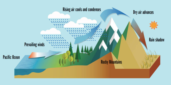
they are created by rain shadows due to high altitudes nearby

pressure and temperature
air masses influence the weather and temperature on earth
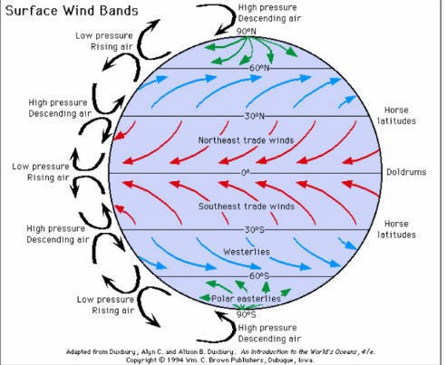
hot air raises, pressure decreases
after reaching certain altitude in the atmosphere, the air is cooled down, so begins to descend
descending cooler air gains the pressure
the air masses flow from equator to the poles as warmed air tends to flow to the coldest areas
due the wind bands of rising and descending air being created, rings of different pressure create

POLAR AREAS (why are they extreme?)
extremely low temperature
lack of heat for survival
difficult environment for agriculture
special tools (ex. to cut through thick ice)
special clothing (ex. special shoes to walk on ice)
difficulties with starting an engine (ex. snow mobiles)
polar nights/days (ex. 6h in Alaska)
more difficult to do activities at dark
lack of vitamin D
affecting our sleep schedule
access to water/resources is limited (frozen)
HOT ARID AREAS (why are they extreme?)
extremely high temperatures
impact on our physical health
impact on daily routines (ex. doing stuff at night)
easy for a heat-stroke or dehydration
black clothing absorbs more heat
air-conditioning, lack of big windows
limited amount of water (evaporation)/ resources (ex. food)
**when there is rainfall it usually does not infiltrate into the ground, but rather floats (ex. Moab flood - flash flood)
HIGH MOUNTAIN AREAS (why are they extreme?)
rather cold temperatures
steep slopes
difficulties with travel
difficulties with agriculture
difficulties with building a house
high risk of an avalanche
How relief, climate, human discomfort, inaccessibility, and remoteness present challenges for human habitation and resource development?
steep areas make it difficult to build any infrastructure and to travel
climate makes it difficult to survive without necessary resources
additional effort/resources have to be put in in order to tackle human discomfort
access to certain areas may be limited and special means of travel are required
accessibility may change depending on the season (ex. ice highways in Canada)
glacial physical processes
glacier retreat >> more and more glacier ice melts
glacier advance >> more and more snow freezes
snow line >> boundary between the accumulation zone and the ablation zone on glaciers
inputs >> snow accumulation, avalanches, debris, heat, meltwater
stores >> ice, water, debris, moraine
outputs >> ablation (ice to water), sublimation (ice to vapour), sediment
glacial budget:
accumulation > ablation, glacier advances
accumulation < ablation, glacier recedes
accumulation = ablation, glacier remains the same size
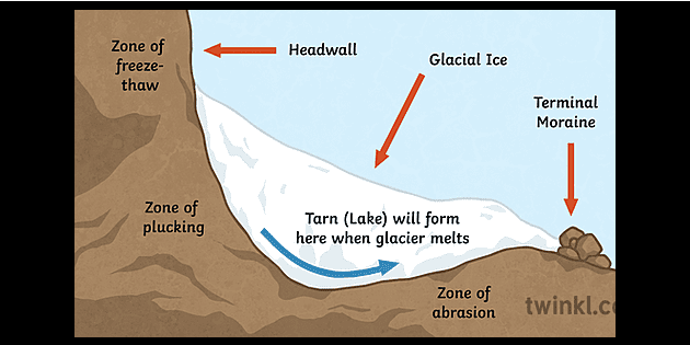
glacial erosion >> processes that occur directly in association with the movement of glacial ice over its bed, such as abrasion, quarrying(plucking), and physical and chemical erosion by subglacial meltwater
plucking >> a process of erosion that occurs during glaciation. As ice and glaciers move, they scrape along the surrounding rock and pull away pieces of rock which causes erosion
abrasion >> happens when the glacier, after plucking up rocks from the ground, uses the rocks stuck beneath it to scrape and grind against the surface of the earth. The weight of the glacier creates an intense force that allows it to rub the earth like sandpaper, producing fine particles of rock beneath it
other >> meltwater, freeze-thaw weathering, pressure release (not strictly glacial, but required for glacial processes)

glacial landscapes
cirques - an amphitheater-like valley formed by glacial erosion
arete - a narrow ridge of rock that separates two valleys
pyramid peaks/horns
v-shaped valleys
u-shaped valleys
hanging valleys
col - a sharp-edged gap that forms between two cirques converging from opposite sides of a crest
ribbon lake - a large, narrow lake occupying a u-shaped valley
glacial deposition
till - the sediment deposited by a glacier; it blankets glacier fore fields, can be mounded to form moraines and other glacier landforms
moraine - loose rocks, weathered from the valley sides and carried by glaciers
terminal moraine >> forms at the very end of a glacier, telling scientists today important information about the glacier and how it moved
lateral moraine >> forms along the sides of a glacier
medial moraine >> found on top of and inside an existing glacier; two lateral moraines from the different glaciers are pushed together; this material forms one line of rocks and dirt in the middle of the new, bigger glacier
drumlin - oval-shaped hills, largely composed of glacial drift, formed beneath a glacier or ice sheet and aligned in the direction of ice flow
erratic - a boulder of a drifferent rock copared to the landscape around
karst processes
topography formed from the dissolution of soluble carbonate rocks such as limestone, dolomite, and gypsum
thermo-karst - an erosional process unique to permafrost with excess ice // not dissolving, but thawing
permafrost processes
permafrost - ground water which has been frozen for at least two years
freeze-thaw action - repeated freezes and thawing’s cause rocks to split up
frost heave - freezing water forms long ice crystals that grow up from the penetration limit
ice wedge - repeated freezes and thawing’s cause the ice to form deeper into the ground and create a thick ice wedge
patterned ground - repeated freezing and thawing of groundwater forces larger stones toward the surface, as smaller stones flow and settle underneath larger stones
pingos
a result of hydrostatic pressure that has built up within the core of pingos due to water
result from groundwater flowing from an outside source
desert processes
physical weathering - occurs when physical processes affect the rock, such as changes in temperature or when the rock is exposed to the effects of wind, rain and waves
chemical weathering - involves the interaction of rock with mineral solutions (chemicals) to change the composition of rocks
granular disintegration - a form of weathering where the grains of a rock become loosened and fall out
exfoliation - a form of mechanical weathering in which curved plates of rock are stripped from rock below
desert landforms
desert pavements - a result of deflation; smaller particles are transported by the wind and bigger, heavier particles are left behind
ventifacts - created by smaller particles hitting against a side of a bigger particle
mushroom rocks - formed from an originally flat area of hard rock overlying soft rock
dunes - created when wind deposits sand on top of each other until a small mound starts to form
loess - formed by the accumulation of wind-blown dust
plateau - can be created by wind or irregular rainfall (wadi)
alluvial fans - area where the material from flash floods is deposited