ENVS 222 Midterm 2 Study Guide
1/103
There's no tags or description
Looks like no tags are added yet.
Name | Mastery | Learn | Test | Matching | Spaced | Call with Kai |
|---|
No analytics yet
Send a link to your students to track their progress
104 Terms
Recite the eons, eras, and epochs of the geologic record in order. What were the Precambrian Eons?
Eons: HAPP - Hadean, Archean, Proterozoic, Phanerozoic (HAP - Pre-Cambrian)
Eras: Paleozoic, Mesozoic, Cenozoic (PALEO - “p”ast, MESO - middle, CENO - “c”urrent)
Periods in Paleozoic: Cambrian (ended 485), Ordovician (ended 443), Silurian, Devonian, Carboniferous, Permian | Triassic, Jurassic, Cretaceous | Paleogene, Neogene, Quarternary
THINK: Camels Often Sit Down Carefully Perhaps, Their Joints Creak, Perhaps Not Quietly

Plate tectonics: importance of theory & what actually happens
Unified theory for how Earth works; it explains the movement of the Earth's lithosphere and the processes that create oceanic and continental features (volcanoes, earthquakes, mid-ocean ridges, the three kinds of faults - normal, reverse, and strike-slip) + dictate the distribution of plants and animals.
It states that Earth's outermost layer is fragmented into tectonic plates (pieces of the lithosphere) that move relative to one another as they ride atop hotter, more mobile mantle material. What causes lithospheric plates to move? Convection cells: Hot, less dense rock rises, moves sideways, cools, becomes denser, and then sinks, creating a continuous loop.
The Theory of Plate Tectonics builds on Wegener's Theory of Continental Drift; later established that continental drift was caused by plate tectonics
Continental drift
Coined by Alfred Wegner; observed that the continents move position on Earth’s surface using 4 major pieces of evidence. Later established that continental drift was caused by plate tectonics
What evidence demonstrates South America and Africa were once connected?
4 pieces of evidence for continental drift:
Can’t Really Feel PP:
1) Continental fit - continents fit together like a jigsaw puzzle, especially SA and Africa => possibility that they were connected earlier in Earth’s history (e.g. during the Carboniferous Period)
2) Rocks and structures - similar between South SA, South Africa, Antarctica, India, and Australia => land bridges used to exists between
Alexander Du Toit reconstructed Gondwana (ancient supercontinent) based on similar strata between Antarctica, South Africa, South America (Brazil), India. He represented the Carboniferous, Permian, Triassic, and Jurassic periods in his stratigraphic evidence.
3) Fossils - Glossopteris flora (seed “fern” of late Carboniferous and Permian) & ratites (rheas, emus, ostriches) present in South SA, South Africa, Antarctica, India, and Australia associated
Additional fossils: Mesosaurus (freshwater reptile) in SA and South Africa & Lystrosaurus (Antarctica, Africa, India)
4) Paleoclimates - deposits in Antarctica, SA, South Africa, and India indicate that different areas were experiencing same climates at same time => they were once connnected
Glacial deposits show directions of continental shift via striation directionality, tills, and dropstones for marine environments
SA and South Africa: tillites (glaciation & colder climates) & coal deposits (high productivity)
Tillites: lithified version of till - glacial deposit
1 additional piece of evidence for plate tectonics:
5) Polar wandering - paleomagnetic signatures of rocks that were magnetized at the time of formation indicate the direction and declination (the angle between Earth’s geographic and magnetic North pole) of Earth’s magnetic pole at a given time. When plotted for rocks of different ages from the same continent, these directions appear to trace a path — an apparent polar wander path — suggesting that the magnetic pole has moved relative to the continent over time. However, rather than the magnetic pole moving (because the magnetic poles are globally consistent), these patterns imply that continents were moving in relation to the pole, carrying with them rocks that had been magnetized when the continents were in diff. positions
How does paleomagnetism indicate continents moved?
Magnetic striping & polar wandering
“Polar wandering”: Paleomagnetic signatures of rocks that were magnetized at the time of formation indicate the direction and declination (the angle between Earth’s geographic and magnetic North pole) of Earth’s magnetic pole at a given time. When plotted for rocks of different ages from the same continent, these directions appear to trace a path — an apparent polar wander path — suggesting that the magnetic pole has moved relative to the continent over time. However, rather than the magnetic pole moving (because the magnetic poles are globally consistent), these patterns imply that continents were moving in relation to the pole, carrying with them rocks that had been magnetized when the continents were in diff. positions.
Additionally, paleomagnetism manifests as magnetic striping (symmetrical patterns of alternating magnetic polarity found on either side of mid-ocean ridges) on the seafloor, which matches patterns of magnetic reversals in Earth’s history. This indicates seafloor spreading over time, which supports continental drift (specifically, the divergence of plates)
How did paleomagentism in the 1960s show new lithosphere formed on ridges and migrated away from ridges?
Paleomagnetism in the form of magnetic striping (symmetrical patterns of alternating magnetic polarity found on either side of mid-ocean ridges) on the seafloor matches patterns of magnetic reversals in Earth’s history. Younger rocks that reflected Earth’s most recent polarity were closer to the MOR’s “spreading zone”, while older rocks were further away - this indicates seafloor spreading over time where new lithosphere is formed on ridges & migrates away
How did features on the seafloor support plate tectonics?
On top of paleomagnetism and mid-ocean ridges, features like deep-sea trenches (e.g. Mariana, Tonga) reflect convergent boundaries (movement of plates toward each other) that led to the subduction of one oceanic plate under another plate. Also, patterns of earthquakes (faulting) and volcanoes align with plate boundaries, supporting the presence of lithospheric plates that interact with one another.
What did mapping of ocean floor reveal?
Marie Tharp mapped by putting together seismic profiles that revealed perfectly symmetrical MOR, became evidence for seafloor spreading (b/c of magnetic striping) & subduction (b/c of deep ocean trenches)
What did Henry Hess discover about seimsic velocity and guyot formation.
Mapped structure of mid-ocean ridge and determined its relation to temperature and seismic velocity (the rate at which lithospheric plates move). Discovered that seismic velocity decreases with higher temperature and fracturing and is “normal” when temperature is lower and fractures are healed. This is because seismic waves travel more efficiently in highly rigid, denser, and elastic mediums; hotter temperatures (by “softening” the rock or even making it partially molten) and fracturing (by creating space w/in the rock and interrupting unformity), thus, decreases seismic velocity.
In 1962, Hess began to measure seismic velocity by studying guyot formation: submerged volcanoes that have diverged away from mid-ocean ridges. Guyots on the oceanic crust created by MORs after it has moved away from the ridge and accumulated enough volcanic activity to rise above sea level, and, over time, sinks due to thermal subsidence. Hess assumed that the age of the guyot (time since formation at sea level) corresponded to the time seismic waves had been traveling through the underlying oceanic crust.
He calculated this using r=d/t, where d is the distance between the guyot and the ridge and time was how long it took for the guyot to travel away from the ridge (i.e. age of the guyot).
How fast do plates move?
1 - 10 cm/year (fastest is ~15)
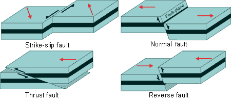
Why do faulting and volcanism occur along oceanic plate boundaries? What are the types of faults and what boundary interaction are they associated with?
Because that’s where plates interact with each other and create conditions for faulting and volcanism through fractures & magma formation!
Normal fault: hanging wall (THINK - STICKS OUTWARDS, POINTY) moves down relative to foot wall, where hanging wall and foot wall are both fault blocks. Caused by rifting at divergent boundaries (tensional forces)
THINK: HW is Down to “hang” out - as they should be, that’s normal!
Horst and graben formed from normal faults - horst above, graben below
Reverse fault: hanging wall moves up relative to foot wall. Occurs at convergent boundaries (compressional forces)
Thrust fault: Low-angle reverse fault (angle between HW plane and FW plane is more acute)
Strike-slip/transform fault: Fault blocks move laterally against one another. Occurs at transform boundaries (shear stress)
How does subduction happen?
Denser, oceanic crust is subducted under less dense oceanic or continental crust at a convergent plate boundary. It is caused by slab pull and ridge push behavior. Slab pull is where a dense oceanic plate sinks into the mantle at a subduction zone due to gravity, pulling the rest of the plate behind it. Ridge push is a secondary force where convection cells push a plate away from a mid-ocean ridge.
How old are rocks in deep-sea floor? What does this indicate?
Only 180 mya (points to Jurassic) compared to much older rocks on land - shows that ocean basins are relatively young! This indicates that the rocks we have on land had to have been preserved on land.
Rocks on the ocean floor are young because they are constantly being recycled through the processes of seafloor spreading and subduction. At mid-ocean ridges, magma rises from the mantle to create new oceanic crust, which then spreads away from the ridge. Eventually, this old oceanic crust eventually reaches subduction zones (deep-sea trenches) where it is pushed back into the Earth's mantle, where it is melted and recycled.
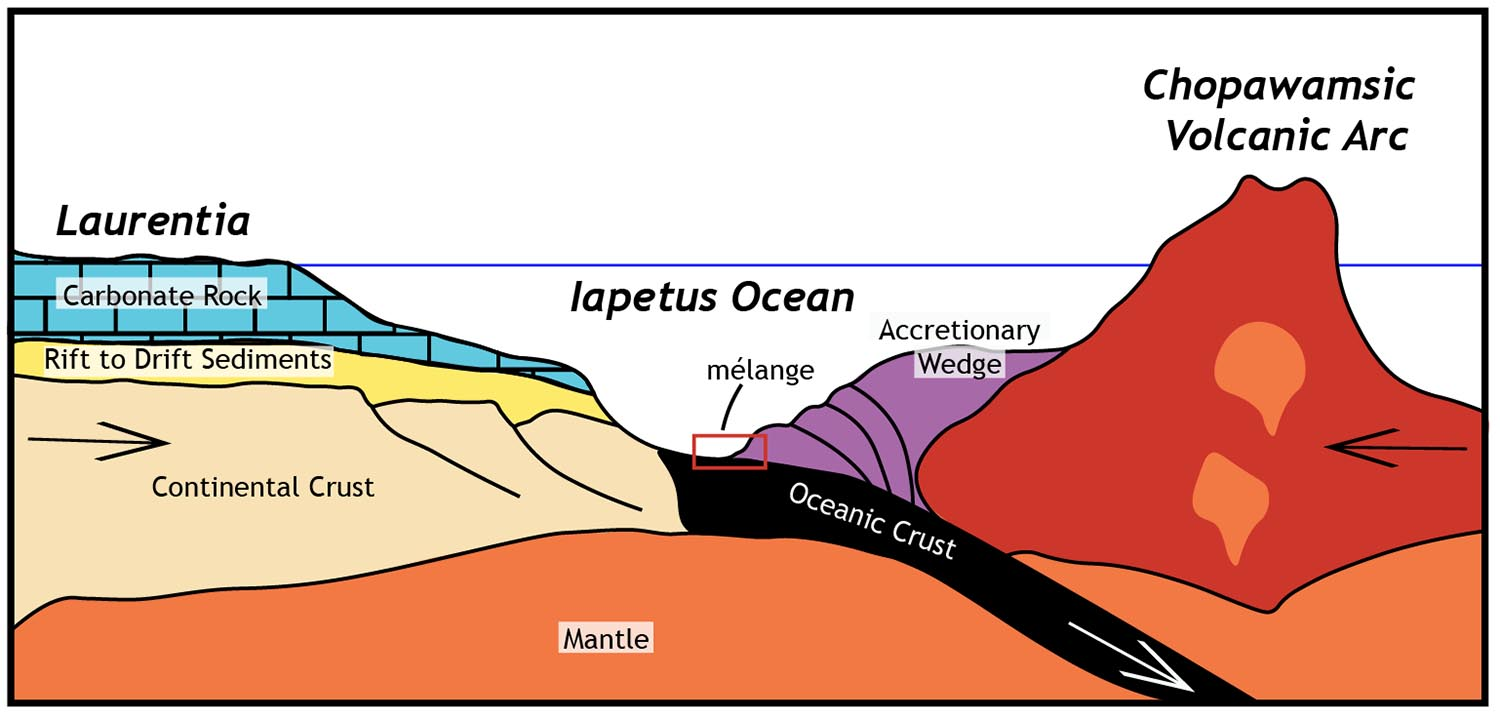
Define the ring of fire in terms of the typical features of a subduction zone.
Tectonic belt of volcanoes and earthquakes around the edges of the Pacific Ocean, and is associated with subduction zones. In these zones, we find three features: a volcanic arc or line of active volcanoes on the overriding plate (usually closer to the continent), a deep-sea trench that marks where the oceanic plate subducted, and earthquakes that occur along the subducting plate b/c of intense friction & stress due to subduction..
How does an accretionary wedge occur and what does it cause?
Accretion of deep-sea material at a deep-sea trench. This causes deep-sea sediments to pile up (+ continental crust material, if oceanic-continental) and metamorphose due to high heat and pressure, leading to a melánge (large-scale body of rock characterized by a chaotic mixture of fragmented rock blocks)
Define hot spots.
Spot of volcanic activity in the middle of a plate (e.g. active volcanism in Hawaii’s Big Island). Volcanic island chains (not to be confused with arcs, which only form at subduction zones) are formed when plates move over the stationary hot spot.
In the case of Big Island: a stationary hot spot (a thermal plume) lies beneath the Pacific Plate → Magma rises from this hot spot and creates a volcano on the seafloor. → As the volcano builds up, it can become a volcanic island (like those in Hawaii) → The Pacific Plate moves northwest over the stationary hot spot → The old volcano moves off the hot spot — it becomes extinct because it no longer has a magma supply → A new volcano begins to form directly above the hot spot, creating a chain of islands that get older toward the northwest → volcanic island arc is formed, and the Big Island is, thus, the youngest island!
Hot spots can also cause intraplate earthquakes due to magma movement (happens in Hawaii!)
Where’s Iceland? What makes it special in terms of volcanic and seismic activity?
Straddles mid-atlantic ridge, where NA plate and Eurasian plate diverge. Here, a hot spot coincides with a divergent plate boundary, resulting in volcanism and fault-related earthquakes.
Where does volcanism occur?
Mostly at speading centers (where faulting also occurs - which makes mid-ocean ridges asymmetrical!), like in Iceland. Spreading zones produce a greater overall volume of volcanism, most of which is underwater and less visible.
But also at:
Hot spots → volcanic island chains: Hawaii
Oceanic-oceanic subduction zone → volcanic island arc systems: Japan & Philippines
Oceanic-continental subduction zone → continental volcanic arc: Andes, Cascades
Is CO2 released from eruptions?
CaCO3 materials are subducted into the asthenosphere; when eruptions occur and magma is brought to the surface, CO2 is released!
What are the 3 types of convergent boundaries & what occurs at them?
CO: continental volcanic arc systems (e.g. Cascade Mountains in northwestern America, Juan de Fuca plate subducted under the NA plate & Andes mountains)
CC: non-volcanic mountain range (e.g. Himalayas)
OO: volcanic island arc systems (e.g. Phillipines, which is next to Mariana Trench, and Japan)
Volcanism occurs b/c denser oceanic plate subducts beneath the lighter oceanic/continental plate, melts, and creates magma that rises to form a volcanic mountain range on the overriding plate
Triple junction (or triple rift junction). Compare two examples.
3 divergent zones often associated with a hot spot.
EX 1: Afar Triangle in East Africa, where the Red Sea, Gulf of Aden, and northernmost point of the East African Rift meet.
EX 2: Late Triassic rifting at a triple junction, led to opening of the Atlantic Ocean. This released CO2 and methane upon divergence, and led to the extinction of many species
Diff: Afar Triangle did not create a substantial body of water such as an ocean basin due to a failed arm (the East African Rift), while late Triassic rifting led to the creation of an ocean basin (Atlantic).
Yes or no: ocean basins were formed from continental rifting
Yes
Folding
Type of deformation in which originally planar surfaces, such as sedimentary strata, are bent or curved ("folded")
How is stress applied during folding?
σ = F/A = ma/A (A = area, σ = stress)
Faulting vs. folding
Two types of rock deformation caused by stress on Earth's crust: folding and faulting. Both typically occur at plate boundaries, but can also happen within a plate.
Folding occurs when rocks are compressed and bend, creating arch-like (anticlines) and trough-like (synclines) structures. Faulting is a fracture or zone of fractures between two blocks of rock, where blocks then move relative to each other and create a fault plane. This occurs when stress exceeds the rock's strength, and can result in features like rift valleys and block mountains.
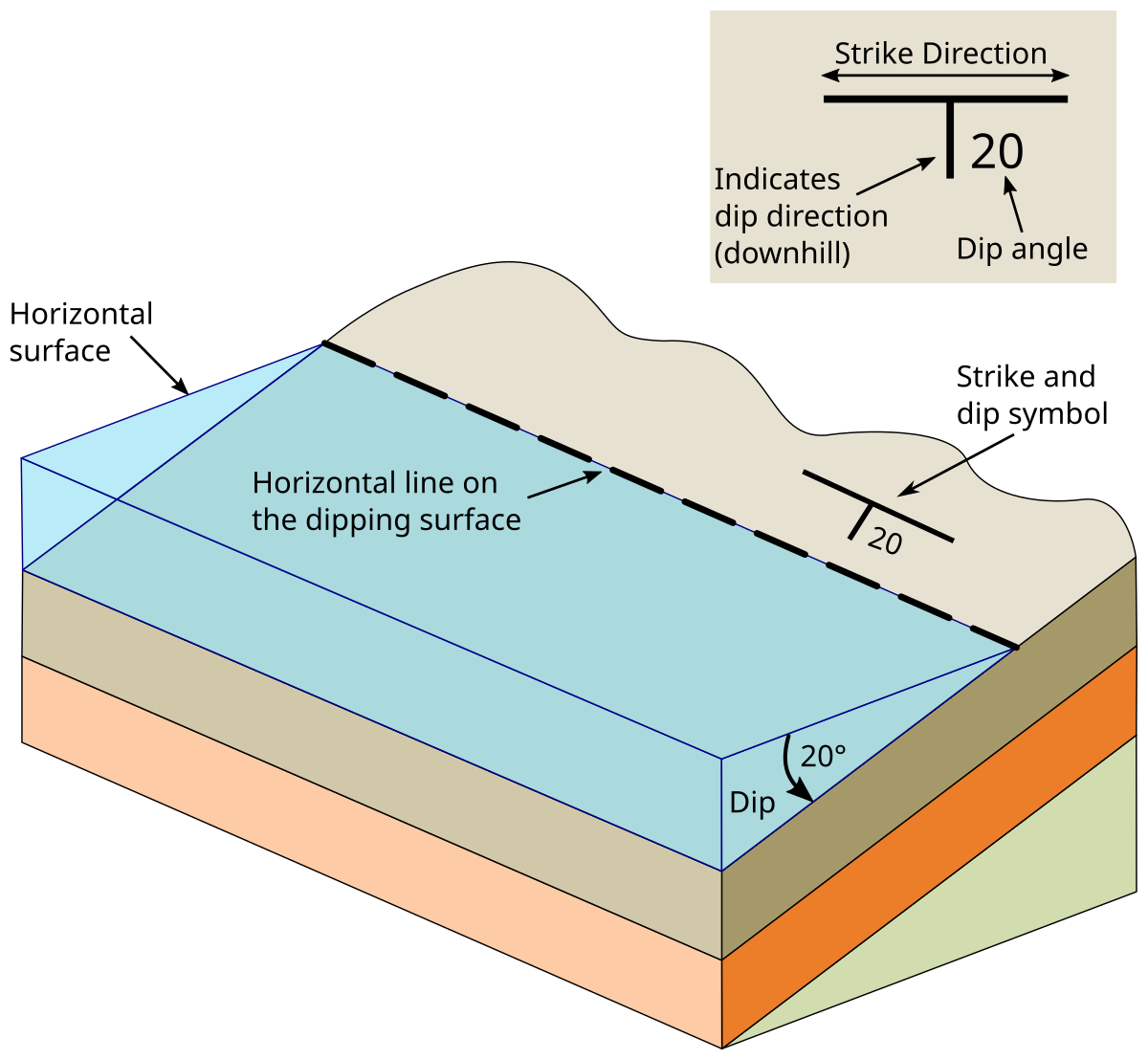
Define terms related to folding: dip, strike, axial plane)
Angle of Dip: the angle and direction of the rock layers tilt when folded
Line of Strike: perpendicular to direction of dip
Axial plane: imaginary surface that divides a fold as symmetrically as possible, in which the hinge line lies
Types of folds.
Overturned folds: folds are tilted (axial plane is tilted, moves off of vertical), caused by unequal amounts of stress and differential types of deformation when there are different boundaries on different side of the plate
Syncline: downward fold pointing up (trough), youngest rocks in center [syncline = youngest at center b/c y at center of “syn”]
Anticline: upward fold point down (arch), oldest rocks in center (anticline - arch)
Non-plunging anticline: hinge line where two limbs of the fold meet is horizontal
Plunging anticline: axial plane (which contains hinge line) dips or “plunges” into the ground, so one end of the fold is deeper; on map/horizontal cross section = v-shaped pattern that points in direction of plunge
Dome: oldest rocks in center, vertical cross-section - strata are folded upward
Can be caused by igneous intrusion, such as the uplifted pluton that created Stone Mountain (domes can form a mountain, but not all mountains are domes)
Basin: youngest rocks in center, vertical cross-section - strata are folded downward
Two types of basins associated with volcanic arcs: chains of volcanoes that occur at a subduction zone - forearc and foreland
Forearc: front of arc system, between the trench and the arc, usually closer to sea (seaward)
Foreland: back of arc system OR mountain belt, closer to land (landward); usually do not occur with island arcs
How do volcanic arcs form?
Occur at subduction zones, where magma generation occurs due to the subducting plate relasing water into overlying mantle, the mantle melts to form magma, and the magma rises through overriding crust. NOTE: not all subduction zones form volcanic arcs, but all form trenches
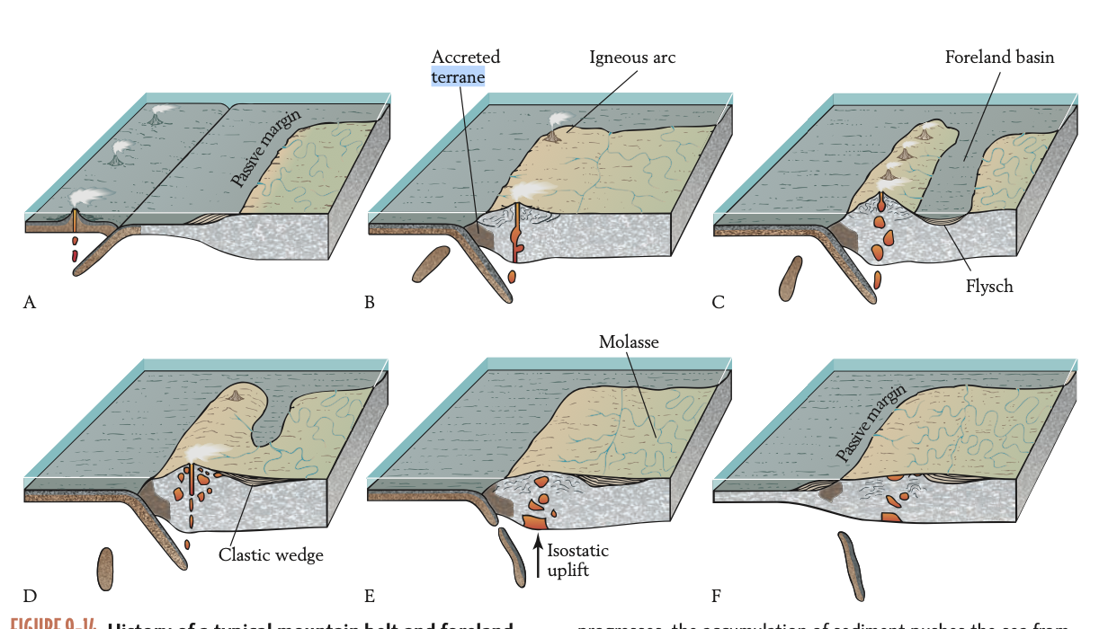
How does mountain building occur? Use suture, accreted terrain, ophiolite, and fold and thrust belts.
Mountain building (orogeny) occurs either from continental collisions, subduction-related arcs, or even hot spots (to a lesser extent).
Continental collisions: one plate is subducted under another in an oceanic-oceanic boundary, with both plates carrying continents → the plates ceases to be subducted once its continent reaches the subduction zone, resulting in a oceanic-continental boundary where the continental is more resistant to subduction → subduction switches to the plate with the oceanic boundary, and terrain from the two’s collision is accreted onto a continent (accreted terrane: entire block of crust becomes “attached” to the plate’s continent) → the two continents collide in a continental-continental boundary in a junction called a suture, which leads to uplift and creates ophiolite: remnants of seafloor that is pinched up along the suture.
EX: Himalayas, Pyrenees
Island/Continental arcs: Occur at oceanic-continental or oceanic-oceanic subduction zones, where magma generation occurs due to the subducting plate releasing water into overlying mantle, the mantle melts to form magma, and the magma rises through overriding crust.
EX: Andes Mountains
NOTE: not all subduction zones form island arcs, but all form trenches
During mountain building, extensive compression often produces fold and thrust belts — regions of the crust with repeated folding (anticlines and synclines) and thrust faults — which contribute to mountain building. EX: Rocky Mountains, where older rocks were thrust above younger rocks
How does thrust faulting develop?
An overturned fold gives rise to a low-angle reverse fault. As force continues to be applied to the fold, faulting occurs.
How are foreland basins created?
Due to the weight of a mountain belt, the lithosphere next to it is “downwarped,” producing an elongated foreland basin. It accumulates flysch: deep-sea sediments (shales and turbidites) that accumulate in the basin once it is inundated with water. The accumulation of sediment pushes the water out of the foreland basin, when it then accumulates molasse (nonmarine sediment) until the mountain chain wears down, with a thick body of molasse being a clastic wedge. The root remains and isostasy causes the mountain belt to bob up again at different intervals, even after orogenic activity has stopped.
Relate the rate of plate movement to the angle of subduction.
Faster-moving oceanic plates tend to subduct at steeper angles, while slower-moving or younger, more buoyant plates subduct at shallower angles.
What happened with the foreland basin in the Andes Mountains?
When the Andes Mountains were created, the sheer weight of the orogen resulted in the formation of a depression or foreland basin. As the foreland basin filled in with sediments and its marine water receded, freshwater runoff coalesced to form the Amazon River. The Amazon is home to freshwater sharks, dolphins, and other organisms that are descendants of the marine ancestors that previously occupied the foreland basin.
Define chemical reservoirs. Discuss flux and feedback in relation to reservoirs.
Bodies of chemical entities that occupy spaces of Earth: atmosphere, oceans, biomass, and crust portions comprising rocks such as coal and limestone (coal = part of biosphere/organic carbon, limestone = geologic/inorganic carbon)
Flux: expansion and contraction of reservoirs with rate changes for elements or compounds flowing through them.
Feedbacks: negative (opposes expansion of reservoir) and positive (accelerates expansion)
EX: negative - sequestration of CO2 in biomass as more CO2 is emitted into atmosphere; fertilization effect of CO2 on plants is negative feedback against atmospheric buildup
EX: positive - global warming means northward expansion of coniferous forests → forests absorb more heat than tundra → more heat radiated into atmosphere → global warming
Balloon example: water enters balloon, balloon expands, exerts backpressure to balance pressure of inflowing water by controlling outflowing water → inc of rate of inflow and pressure leads to expansion that outpaces backpressure, increasing outflow → backpressure equalizes inflow pressure once again, balloon is bigger but stable
Photosynthesis and cellular respiration:
Photosynthesis: sunlight → CO2 + H2O → C6H12O6 + O2
Captures energy, creates sugar
Cellular resp.: C6H12O6 (CH2O) + O2 → CO2 + H2O → energy released for metabolism
Releases energy through oxidation of reduced carbon
Leads to gas exchange w/ environment
Describe respiration for decomposers.
Decomposers: organisms that break down dead organic debris not consumed by animals via respiration; decomposers in soil typically need O2 (aerobic respiration)
Respiration used to break down tissues of dead organic material, extracting O2 and releasing CO2.
How does burial of dead plant tissues affect atmospheric CO2?
High burial → low decomposition → less CO2 in atmosphere
High burial of dead plant tissue means more carbon is stored in the lithosphere (becomes reservoir for reduced carbon) → low decomposition b/c buried plant tissue isolated from oxygen and surface decomposers (which also rely on oxygen to decompose debris) → less CO2 released because stored underground
Usually balanced by erosion → even with high burial & lithification of dead plant tissues, weathering and erosive processes can release stored CO2 into the atmosphere
In marine environments, planktonic algae = “plant tissue”
Where is organic carbon buried in large quantities?
Coal (lithified, dead plant tissue) & black shale (result of anoxic marine environments in mid-Cretaceous ~100 mya)
Black shale was formed when carbon was introduced to ocean by rivers (fluvial enviornments) and, with high amounts of marine plankton (with decomposes who attempted to decompose plankton disproportionately using up oxygen), made oceans relatively anoxic. Warmer, anoxic ocean water allowed for black shale preservation throughout the Cretaceous. The organic-rich muds lithified into black shales (carbon sinks).
How do stable oxygen isotopes reveal the geologic history of temperature?
18O/16O ratio: specifically analyzed Cretaceous rudist clam shells extracted from limestone, discovered that higher ratio (more 18O) associated w/ lower temperatures (colder temp → ocean water becomes enriched in 18O)
Ratios depend on temp. & salinity
BUT: recrystallization can change ratio values!H
igher ratio during glacial periods and lower during interglacial, reflected in Pleistocene record of glaciation
How do stable carbon isotopes reveal geologic history of carbon burial?
13C/12C ratio: higher ratio (more 13C) in atmosphere associated w/ high burial rates (reflected in Paleozoic pattern (which had more 13C)), and often cooler temperatures.
Reason 1: 12C used by plants (and marine phytoplankton) in greater proportion than what is in atmosphere. Hgh burial means more dead plant matter and, thus, 12C is buried and stored w/in the lithosphere. Less 12C is then emitted due to unfavorable conditions for aerobic decomposition, leaving more 13C than 12C in the atmosphere.
Carboniferous: 300 mya → high burial → coal forest → more 13C in atmosphere
Reason 2: Methane released during decomposition. Decomposition of dead plant tissue → methane released into oceans, which is a primary 12C source. If water is colder, higher burial rates occur (decomposers become less productive). Thus, methane is frozen and becomes methane hydrate, meaning that more 12C is stored in the lithosphere and more 13C is available in the oceans/atmosphere.
Methane hydrate. What produces it? Where is it found?
Frozen methane. Reflective of a positive feedback loop, where warmer temperatures mean that more methane is released into the atmosphere due to more active decomposition, and methane as a potent greenhouse gas then blocks outgoing longwave radiation and warms the planet even more.
Stored on sea floor, deep under tundra, and on continental slopes. Mostly produced by archean prokaryotes.
What were rudists?
Cretaceous reef builders whose oxygen isotope ratios from limestone indicates seasonal temperature changes & that overall temperatures in Cretaceous were warmer
Relate stable isotopes to glaciers.
In a stable system w/o significant glaciation, isotopically light water (lower 18O:16O ratio) evaporates more easily, forming clouds above land. Rainwater then precipitates that isotopically light water, which returns to the ocean via rivers.
In a positive feedback loop featuring heavy glaciation (e.g. a continental glacier), isotopically light water evaporates more easily and forms clouds above land. However, the glacier acts as a new reservoir for isotopically light water on land, trapping it. This means that not as much isotopically light water is returned to the ocean via rivers, meaning that the ocean becomes isotopically heavier.
How do plate tectonics affect atmospheric CO2?
When marine limestone sinks to the ocean floor and gets subducted, it takes with it the CO2 used to form it. This results in less CO2 available in the oceans and the atmosphere. At the same time, CO2 is consumed in the formation of carbonic acid, which weathers marine limestone. Thus, subduction and weathering are long-term carbon sinks. However, tectonic processes like volcanism (alongside methane hydrate thawing, heating of carbon-rich rocks, etc.) can at subduction zones or MORs can release CO2 back into the atmosphere.
How does weathering affect atmospheric CO2? Discuss in terms of stable/unstable systems and general abiotic/biotic factors.
Stable: when the burial rate balances the weathering rate, we have a stable carbon isotope ratio in the atmosphere. This is because while more 12C is buried, weathering of that lithified organic matter releases 12C back into the atmosphere in the long-term.
Unstable: burial rate exceeds the weathering rate indicates that heavier carbon (13C) is left in the atmosphere.
Mountain building: more weathering/erosion, less CO2
Temperature: higher temp increases rates of chemical reactions in weathering, less CO2
Precipitation: more precipitation means more chemical weathering, less CO2
Vegetation: more weathering in vegetated areas than non-vegetated areas, less CO2
What happened to O2 between the Carboniferous and Permian?
Increased into Permian. An increase in land plants and marine phytoplankton during the Permian meant high photosynthetic uptake of CO2 (and release of O2 as byproduct) and that more carbon was being buried and stored in the lithosphere, decreasing CO2 levels relative to O2 levels. After the Permian extinction and the resulting severe decrease in plants and plant-like organisms, O2 decreased before recovering after the Cretaceous.
What happened to CO2 during the Cambrian and Carboniferous? How about after the Permian?
Cambrian - Increased. This is because of the Cambrian Explosion, which led to the expansion of animal life and increased cellular respiration as well as limited plant life.
Carboniferous to Permian - Decreased due to increase in plant life/biomass, taking out CO2.
After Permian - Increased due to Permian extinction and severe decline in plant life
Describe the CO2 flux.
If CO2 is released at a higher rate than it is stored, our climate warms and chemical weathering (which often necessitates CO2 as a reactant) is strengthened. A stable CO2 reservoir with high rates of CO2 release leads to a very warm climate with very strong weathering.
Relate plate tectonics to Mg/Ca cycling.
Orogeny: More silicate and carbonate rocks are exposed, leading to more weathering. Weathering produces Mg2+ and Ca2+ ions as a byproduct, which can then enter ocean systems and increase Mg:Ca ratios based on their relative abundance.
Subduction: Subduction removes Mg2+ and Ca2+ when carbonate and ultramafic rocks are buried/melted in the mantle. More carbonate burial means high Mg2+:Ca2+ ratios.
Different Mg2+:Ca2+ ratios in oceans affect the composition of calcifying organisms that precipitate CaCO3, with higher Mg2+ meaning shells or skeletons with high-Mg calcite. In general, these ratios can affect how productive calcifying organisms are in precipitation CaCO3.
How did the Cretaceous extinction affect global ocean geochemistry?
Decrease in calcareous nannoplankton, including coccolithophores, which constitutes a major component of chalk. Thus, clays from the Paleogene reveal fewer coccolithophores. Thus, extinctions affect the composition of the ocean crust due to the types of organisms that are preserved.
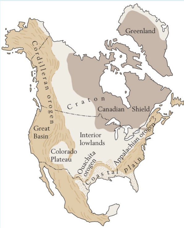
Craton, shield
Craton: Stable interior of continent largely composed of pre-Cambrian rocks
Shield: Portion of craton exposed at surface (EX: Canadian shield)
Where can you find pre-Cambrian rocks and shields?
All continents and subcontinents (e.g. India)!
What can you find on the edges of a pre-Cambrian shield?
Phanerozoic sediments, which are later deposits that result from the pre-Cambrian shield undergoing erosion, and Phanerozoic mountain belts.
What is an igneous intrusion feature in the Candian shield?
Dikes, which cut across rock formations → comparatively younger
Types of meteorites:
Iron-nickle: determined by its cut and polished surface
Stony-iron: composed ~equally of iron-nickle and silicate minerals
Stony: silicate, high in olivine (green-ish)
Explain expanding universe model. What’s the evidence behind it
Expanding universe model: states that the universe is continuously expanding from a central point. Evidenced by redshift and blueshift, which signify that the space between galaxies is increasing:
Redshift: The greater the redshift, the larger the distance between two objects in space (e.g. galaxies). AKA light waves stretch to longer, redder waves when the distance between two objects in space increases, and can be used as evidence that the objects are moving further and further away from each other.
Blueshift: The greater the blueshift, the smaller the distance between two objects in space; often impies that objects are moving toward one another and the length of the light waves that travel between them is decreasing.
Nebular hypothesis:
Explains the origin of our solar system. Began with a spinning collection of matter that then condensed at the center. This centralization of matter increased its spin state, which coalesced denser matter closer to the center and less dense matter on outside, forming rings. This then led to the formation of planets.
What is the asteroid belt? What “objects” does it separate, and what are their characteristics?
Probably a failed planet that tried to coalesce! Features asteroids with an odd orbit, that can and do intersect with Earth’s orbit.
Separates the inner planets (Mercury, Venus, Earth, Mars) from the outer planets (the gas giants - Jupiter, Saturn, Uranus, Neptune)
Characterize the outer plants.
Gas giants b/c primarily composed of gas, even if they have a solid core. Characterized by lots of moons with stony to stony-iron compositions.
How did Earth’s layers form?
Earth was accreted as a generally homogenous, molten body, containing elements like iron, nickel, and silicates. During this stage, it also experienced heavy bombardments from meteorites, which brought more iron, nickel, and silicates. The heavier iron sank to the center of the molten Earth, while less dense material rose to the surface. Eventually, the planet fully differentiated into core, mantle, and crust, and comet collisions brought water!
How did the moon originate?
Likely during the Hadean eon, early molten Earth experienced a lunar-forming giant impact from an object (e.g. a large asteroid). Most of the impactor’s iron core sank to Earth’s. The impact also ejected the impactor’s mantle and a small amount of its core material, creating a rotating magma disk (a ring) around Earth. Later, the magma disk coalesced into the moon.
NOTE: the moon does not have a molten core nor does it experience plate tectonics.
How did Earth’s formation impact radioactive decay?
Earth’s formation included radioactive elements from earlier stars that were then incorporated into the planet. This resulted in high rates of radioactive decay, which released large amounts of heat and led to intense warming during the Archean. Over time, heat production due to radioactive decay decreased as radioactive isotopes decreased in abundance (having decayed into stable daughter isotopes), leading to cooling.
Define greenstone belts, examples, and how they were formed.
Greenstone belts: mini-continents of enriched silica (e.g chlorite) that formed during the Archean Eon. EX: present in Pilbara Shield, Western Australia
Mostly formed at ancient oceanic-oceanic subduction zones, which produced volcanism (and, in turn, volcanic rock) and forearc and backarc basins where oceanic sediments accumulated. These rocks and sediments were then metamorphosed, forming proto-continents (greenstone belts) that coalesced into cratons. This could be considered “primordial land”.
What does this show?
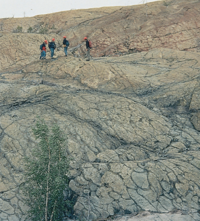
Older pillow basalts planed off by tectonic forces. Present in the Canadian shield, from the Archean Eon.
How did the geochemistry of Earth’s oceans change over time?
Transitioned from mostly precipitating silica during the Archean to mostly precipitating calcium carbonate by the Phanerozoic. This was partially driven by the genesis and expansion of organisms, like prokaryotes that would take in CO2 from the oceans and precipitate it as CaCO3. This also led to a decrease in oceanic and atmospheric CO2.
Specifically, siliclastics in Archean → chert near end of Archean/peaking in early Proterozoic → carbonates increasing steadily through Proterozoic and peaking at end of Proterozoic/early Phanerozoic (w/ small presence of evaporites that slowly increased). Since salinity is necessary for evaporite precipitation, more evaporites imply an increase in oceanic salinity.
What do physical sedimentary structures during the Archean reveal?
Physical sedimentary structures evidencing shallow-marine environments during this period lack burrows, trails, or other trace fossils, indicating the absence of organisms other than bacteria or archaea.
Patterns of regression and transgression are also preserved in Archaean rocks.
Define stromatolites and reefs. When did stromatolites first appear?
Biogenic structures that comprise cyanobacterial mats, where cyanobacteria trap/bind sediment and create folded strata. Considered to be the first reef - a wave-resistant biogenic structure - builders, appearing 3.5 bya in the Archean Eon.
EX: present in Western Australia
Were there eukaryotic cells in the Archean?
Yes; the Archean marked the beginning of eukaryotic cells, though they increased in the Proterozoic. These cells differ from prokaryotic as they are typically bigger, have a central nucleus, and comprise membrane-bound organelles.
What are these?
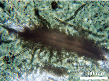
Modern glassy tubes formed by prokaryotes on pillow basalts (similar tubes on South African pillow basalts).
Define abiogenesis. How does this relate to theories about life?
Formation of life from non-living materials. There are two abiogenetic theories about how life first formed:
Older hypothesis: from lightning, which hit shallow water. This led to the creation of amino acids, which led to RNA formation followed by DNA.
Newer hypothesis: life began at MORs, where warm-adapted bacteria and archaea flourished. This theory suggests that this deep-sea life survived via chemosynthesis, where thermophilic prokaryotes fixed sulfur without light energy at hydrothermal vents.
RNA World:
During most of the Archean, almost all life on Earth was transmitting genetic info via RNA. The double helix appeared near the end of the Archean.
Why did large continents not form during the Archean?
Largely due to high heat and tectonic instability. High heat led to a thin lithosphere that was prone to fracturing and melting, high amounts of volcanism and subduction, as well as high tectonic activity (e.g. within protocontinents), destabilizing any kind of primordial land and preventing the formation of large continents.
Why did relatively little free oxygen accumulate in earth's atmosphere throughout the Archean?
During the Archean, oxygen production existed (e.g. due to small colonies of cyanobacteria) but limited, and, thus, consumed at the same pace due to reactions with reduced iron, volcanic gases, and organic matter. Thus, the atmosphere remained largely anoxic.
How did mountains form during the Proterozoic? Give an example.
Plate tectonics → Proterozoic featured stabilized cratons that collided with one another, building mountains as terrane accreted onto continental blocks, as well as that interacted with oceanic plate boundaries at subduction zones, where magma rose up to form continental volcanic arcs. Both produced fold-and-thrust belts - regions of the crust with repeated folding and thrust faults - which further contributed to mountain building.
Wopmay orogeny: body of deformed rocks leveled by erosion that was once a major mountain range, formed by orogeny ~2 bya, Canada. Characterized by high-grade metamorphic belt and fold-and-thrust belt
Heterotrophs vs. autotrophs:
Heterotrophs: obtain energy by consuming organic matter (e.g. autotrophs or other heterotrophs) | multicelled eukaryotes: animals & fungi, single-cell eukaryotes: organisms that have cells with a mitochondrion, and prokaryotes: bacteria.
Autotrophs: produce their own energy through light (photosynthesis) or chemical reactions (chemosynthesis) | multicelled eukaryotes: plants, algae (EX: grypania), eukaryotes: organisms that have cells with a mitochondrion and chloroplasts, and prokaryotes: cyanobacteria.
Define the endosymbiotic theory. When do we start seeing prokaryotes vs. eukaryotes fossilized?
Prokaryotes evolved into eukaryotes when prokaryotes started ingesting and incorporating prokaryotes. We can trace the origin of fossil prokaryotes back to around 1.9 billion years ago (bya), eukaryotes to around 750 million years ago (mya), and the first embryonic animals to around 550 mya (likely sponges) - all likely in the Proteroizoic.
What global climatic and biological changes happening the first half billion years of the Proterozoic?
Oxygen began to accumulate on Earth due to the Great Oxidation Event around 2.3 bya, caused largely by the evolution of cyanobacteria. This resulted in a decrease in anaerobic bacteria and a further increase in cyanobacteria (which further produced oxygen) and heterotrophs (particularly aerobic bacteria that could use aerobic metabolism).
What evidence shows that oxygen began to build up in the atmosphere?
Banded iron formations and redbeds!
BIFs feature alternating red and gray strata, with gray representing sedimentary layers with reduced iron and red representing oxidized iron (hematite), which correspond with seasonal changes in O2 concentrations. Where the red strata started to expand, we can assume that oxygen began to accumulate in the oceans and atmosphere.
Late Proterozoic redbeds are indicative of high iron oxidation. They can often be attributed to an increase in photosynthesizers, which led to increasingly oxidized iron and more iron available to animals.
When did “Snowball Earth” occur? What is the evidence behind it? How did it form?
During the Neoproterozoic (end of Proterozoic), around 780 to 630 mya. Period of glaciation across Earth, corresponding with declining CO2 levels (e.g. b/c weathering increased as continents formed).
Evidence: tillites - lithified, unsorted glacial sediment - across the globe.
How did “Snowball Earth” end? Name a few things that happened after.
Ended when CO2 levels began to build up due to processes like volcanism, which started a positive feedback loop when ice thawed, more heat was absorbed by land, and hotter temperatures accelerated the thawing of ice.
Warming, post-glacial oceans then resulted in the increased formation and precipitation of carbonates as well as in an increase in stromatolites (which thrive in shallow-marine environments with warmer waters). Additionally, post-glacial warming increased erosion and sediment delivery to the oceans, producing more turbidites - deposits from turbidity currents - on continental slopes and in deep marine basins.
What change in physical environment may have triggered the explosive diversification of animal life 650 mya?
When Earth got warmer following a period of widespread glaciation, carbonates began to form and precipitate (e.g. calcite, aragonite) while stromatolites proliferated. Additionally, warming temperatures accelerated biological processes, particularly for animal life. This led to more complex life that could now occupy a multitude of ecological niches, resulting in explosive diversification.
What is Proterozoic “elephant skin” and what does it show?
Texture in Proterozoic rock that reveals the shrinkage of microbial mats, made by cyanobacteria and algae (autotrophs). This shows that heterotrophs (e.g. fungi and animal life) were missing (or at least, not preserved) from the original ecosystem, and were thus lacking in abundance compared to autotrophs, indicating the limited complexity or even absence of the higher trophic level.
What does the pre-Cambrian-Cambrian boundary in Newfoundland, Canada show?
Reveals signs of burrowing in Proterozoic rocks, though animals were small and did not burrow deep in early marine benthic ecosystems. Cambrian and later Cambrian rocks show fossils of deposit-feeding infauna, indicating an increase in burrowing animals and their niches as well as the depth of burrowing into the Cambrian period.
What dramatic evolutionary changes occurred during last 30 million years of Proterozoic?
The last 30 million years of the Proterozoic were characterized by the emergence of Ediacaran biota: multicellular, macroscopic organisms that marked the start of complex animal life. Ediacaran biota featured the first shallow burrowers and, thus, were the first animals to engage in bioturbation, beginning to alter geochemical cycling in the oceans. They laid the foundation for epifauna and infauna lifestyles as well as ecological roles such as suspension feeding and deposit feeding, which expanded significantly in the Cambrian.
What was the ecological transition between the pre-Cambrian and Cambrian periods? How did this affect geochemical cycling?
Ecological transition from marine grazers (epibenthic, epifauna) to marine burrowers (endobenthic, infauna). Burrowing animals broke Proterozoic microbial mats and mixed the soil, allowing for O2 in the water to be incorporated into sediments. Before this, the ocean floor was mostly anoxic. This led to the increased oxidation of elements like sulfur, nitrogen, and phosphorus and the release of carbon that was trapped in microbial mats as CO2, enhancing nutrient cycling.
Additionally, while there was evidence of prediation toward end of pre-Cambrian (e.g. drill holes in shells), but predation expanded significantly in and was foundational for the Cambrian (e.g. the appearance of corals). Generally, the Cambrian was marked by the expansion of animals with skeletons.
How did North America form & what did continental suturing/fragmentation accomplish on a global scale during Neoproterozoic?
Subcontinents into supercontinents because of plate tectonics
Define suspension feeders, deposite feeders, benthic, epibenthic, endobenthic, epifauna, infauna, pelagic, planktonic, and nektonic. Include examples for each.
Suspension feeders: filter particles suspended in water column, extracting organic material. EX: sponges, brachiopods, crinoids, bryozoans, some cnidarians
Deposit feeders: directly consume sediments with organics. EX: trilobites and other arthropods, worms and worm-like animals
Benthic: on floor of ocean/freshwater body
Epibenthic: live on/near surface of a body of water’s floor, such as epifauna. EX: trilobites, brachiopods, early echinoderms
Endobenthic: live in sediment, such as infauna. EX: worms and worm-like burrowers, some mollusks (e.g. clams)
Pelagic: in water column
Planktonic: suspended/floats freely. EX: nautiloids, phytoplankton, cyanobacteria
Nektonic: swims. EX: nautiloids (again!), early fish, primitive chordates (Pikaia)
What do Neoproterozoic diamictites and carbonates reveal?
Neoproterozoic diamictites: dropstones from icebergs when Earth was largely glaciated (during Snowball Earth period). Neoproterozoic carbonates: formed and precipitated in warmer oceans.
Thus, strata containing the two sediments feature diamicites at the bottom and carbonates above, showcasing the transition from Snowball Earth to a post-glacial Earth with warmer waters.
What are the major geologic features of North America? Also, yes or no: sedimentary rocks began to form on the edges of the Canadian Shield during the Proterozoic.
Yes!
What continental masses formed in the Proterozoic?
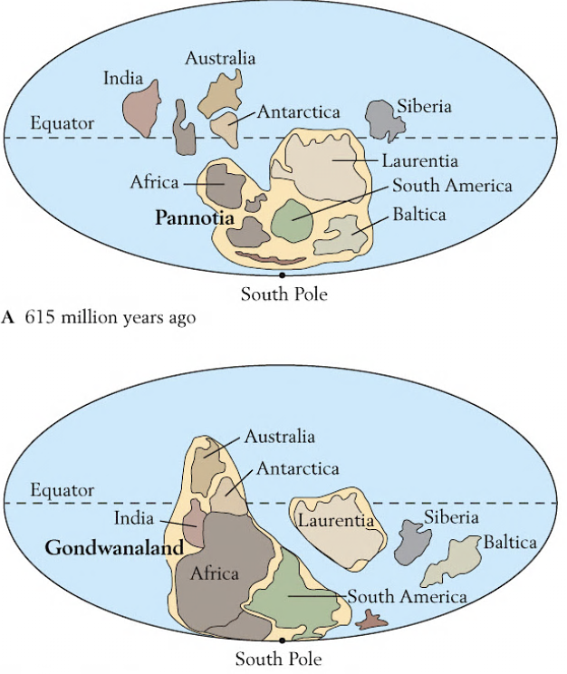
Supercontinents. In order, Nuna (1.74 bya), Rodinia (800 - 650 mya), and Pannotia (615 - 530 mya).
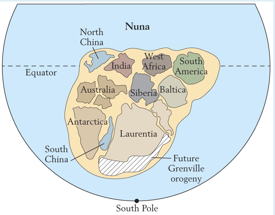
What is this? Describe it.
Nuna; first major supercontinent in the Proterozoic.
What is this? Describe it.
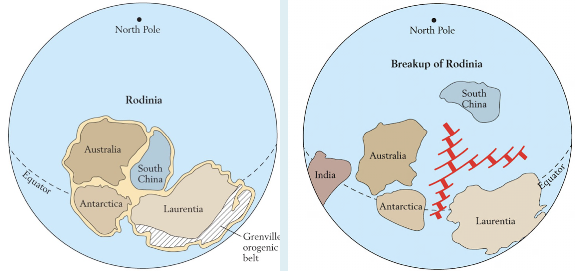
Rodinia; second major supercontinent in the Proterozoic. Formed near the beginning of Snowball Earth and broke up near the end. The spreading of the ocean floor that led to the divergence of its subcontinents may have also led to warmer temperatures (and the end of Snowball Earth) due to increased volcanism.
What is this? Describe it.
Pannotia; final major supercontinent in the Proterozoic. Features Gondwanaland, which became the supercontinent Gondwana in the early Cambrian.
Describe the Cambrian explosion. What kinds of animal skeletons developed during the Cambrian Period?
Cambrian explosion: ~15 my period that began at the start of Cambrian, characterized by the relatively rapid diversification of animals during the period. Included increased numbers of animals with skeletons and the expansion of predation as a trophic level.
Specifically featured:
Expansion of many clades that featured animals w/ calcified and segmented skeletons, such as trilobites, echinoderms, cnidarians (coral), primitive mollusks, and inarticulate and articulate brachiopods, nautiloids (predators, look like squid in cones). Tommotian fauna marked the start of widespread skeletal formation in the Cambrian.
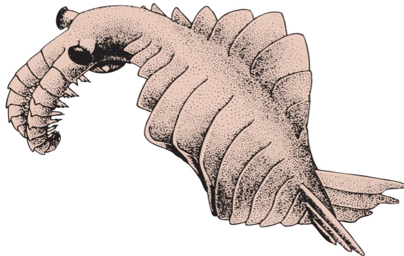
Appearance of Chengjiang fauna - soft-bodied animals including cnidarians and predatory worms - and anomalocarids - huge, nektonic carnivores that impaled prey (picture of anomalocarid attached)
Appearance of primitive chordates, including conodonts, the first fish, and Pikaia
Appearance of Burgess Shale Fauna in western NA, which lived in deeper, suboxic waters and represented one of the most important fossil assemblages. Included Pikaia
Evolution of new modes of life: predators (and big ones) + expansion/solidification of roles such as deposit feeders and suspension feeders
Define Treptichnus:
An example of an ichnogenus: the formal name applied to trace fossils. Treptichnus represented a complex feeding burrow, and was an index fossil that dates to the start of the Cambrian Period.
How did Ordovician life differ from Cambrian life?
The Ordovician featured the evolutionary expansion and diversification of marine animal life in what was called the Great Ordovician Biodiversification Event. It featured:
Expansion of ecological roles, including the extension of infauna (burrowers) into new ecosystems, pumping oxygenated water into sediment, increasing geochemical cycling, and mixing up the layers of the seafloor.
Radiation of shelled/biomineralized animals; AKA the further evolutionary expansion of animals with skeletons (chordates, mollusks, coral, trilobites (such as the big Isotelus), etc.). The number of genera of marine animals with skeletons was far higher than the Cambrian, despite the Cambrian Explosion.
Increased diversity of benthic organisms, including jawless fishes, grazing snails, articular brachiopods, and crinoids.
Formation of coral-strome reefs, built from rugose coral (solitary, colonial coral), tabular coral, and stromatoporoids
THINK: BISC - like lobster bisc cause so rich w/ animal life - benthic diversity, infauna expansion, shelled/biomineralized animal radiation, and coral-strome reefs
What happened to plants during the Ordovician?
Plants invaded land for the first time, though restricted to moist habitats and likely non-vascular plants like mosses and liverworts.
Why did stromatolites decline during Cambrian and Ordovician?
Stromatolites declined during Cambrian and Ordovician b/c they were preyed on by gastropods and other grazing animals, who extracted cyanobacteria and algae from its microbial mats.
What kind of highly successful reef community developed during the Ordovician?
Coral-strome reefs; first “coral reefs,” comprising corals (rugose or horn corals + tabular corals like chain corals) and stromatoporoids! While coral appeared in the Cambrian, reefs (wave-resistant biogenic structures) were primarily made of archaeocyathids - suspension feeders more closely related to sponges.
What is this? Describe it and the paleogeography during this time period
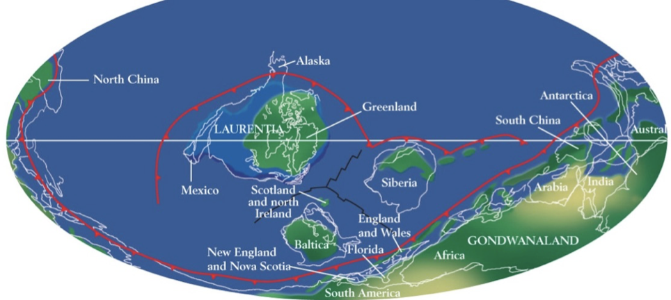
Late Cambrian paleogeography, with Laurenta near the equator and Gondwana in the southern hemisphere.
While some cratons had formed a supercontinent early during the Cambrian, the progressive and abundant flooding of continents eroded cratons due to the inland shifting of seas and deposited sediments around the margin of the continent and other continents. This pattern was only interrupted by regression in the Middle Cambrian and again in the Late Cambrian.