Coasts
1/143
There's no tags or description
Looks like no tags are added yet.
Name | Mastery | Learn | Test | Matching | Spaced | Call with Kai |
|---|
No analytics yet
Send a link to your students to track their progress
144 Terms
Define a system
A system is a type of model that shows a set of components and links between them.
Define the different types of systems
A closed system is energy transfer with no movement of matter.
An open system receives inputs and outputs and matter moves between systems across boundaries.
An isolated system is cut off and there is no transfer of matter or energy across boundary lines.
Define a dynamic equilibrium
Dynamic equilibrium occurs when there are unrepeated average states through time, where its energy and matter are in a steady state over time.
Define a positive and negative feedback loop
A positive feedback loop amplifies a situation in the system.
A negative feedback loop dampens down a situation in the system.
Describe a cascading system
A cascading system in geomorphology is a type of dynamic system characterized by the transfer of mass and energy along a chain of component subsystems, such that the output from one system becomes the input for the adjacent subsystem.
Define the backshore
The backshore is the area between the high water mark and the landward limit of marine activity, in which changes only normally happen during storm activity.
Define the foreshore
The foreshore is the area between the high water mark and the low water mark. It is generally the most important zone for marine processes (except during storms).
Define the nearshore/inshore
The nearshore/inshore is the area between the low water mark and the point where waves cease to have any influence on the land beneath them.
Define the offshore
Offshore is the area beyond which waves cease to impact upon the sea bed and in which activity is limited to deposition of sediment.
Define the swash zone
The swash zone is the upper part of the beach between the back beach and the surf zone, where intense erosion occurs during storms. It is alternately wet and dry.
Define the surf zone
The surf zone is the region of breaking waves. After breaking in the surf zones, shorter waves continue to move in and run up onto the sloping front of the beach, forming a swash.
Define the breaker zone
The breaker zone is the zone within which waves approaching the coastline commence braking (typically in depths between 5 to 10 meters).
Define a storm beach
A storm beach is a higher area at the back of the beach where sediment is only deposited during stormy seas.
Explain how wind occurs
Wind occurs because of the rotation of the earth and differences in atmospheric pressure when different parcels of air are heated differently by the sun.
Define fetch
Fetch is the maximum length of open water over which the wind can blow.
Explain how waves form
- When wind blows across the surface of the sea, frictional drag move the water and creates small ripples and waves
- This leads to a circular orbital motion of water particles in the ocean
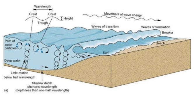
What is the difference between oscillatory waves and translatory waves?
Waves in the open ocean are known as oscillatory waves.
When the water becomes shallower, the lowest circular motion becomes slower due to friction while the upper portion of the waves continues with the original velocity, and so the top of the wave crashes onto shore. These are known as translatory waves.
What are the factors affecting wave energy?
- stronger wind (due to a larger pressure gradient) will create stronger waves
- wind for longer periods of time means energy will build up and increase, creating stronger waves
- a larger fetch will create more powerful waves
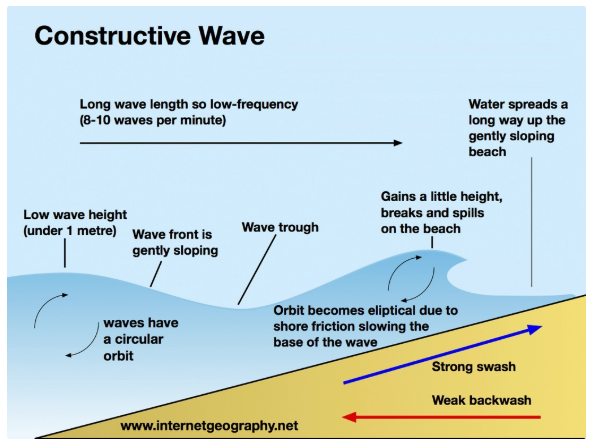
Describe constructive waves
- moves less quickly and loses energy
- strong swash, weaker backwash
- depositional
- long wavelength (100 metres)
- low wave height (less than 1 meter)
- low frequency and high period (1 every 8-10 seconds)
- short fetch
- elliptical orbit
- caused by swell from a distant storm
- surging
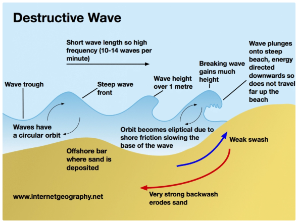
Describe destructive waves
- move quickly and lose little energy
- weak swash, stronger backwash
- erosional
- short wavelength (less than 20metres)
- high height (greater than 1 meter), steep gradient
- high frequency (10-12 per minute) and low period (one every 5-6 seconds)
- large fetch
- circular orbit
- high energy waves generated by storms and local winds
- spilling
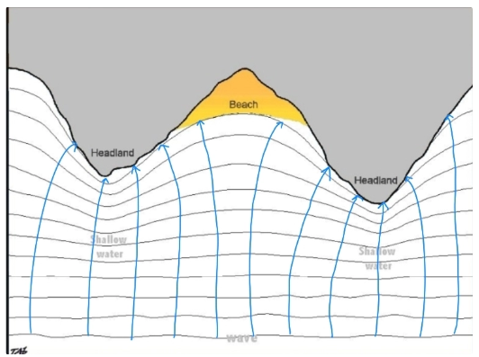
Describe and explain wave refraction
- shallow water is often concentrated around headlands (because of previous erosion of cliffs)
- as waves approach the coastline, they experience friction with the seabed in shallower water
- this causes the bottom of the wave to slow, and so the wave becomes higher, steeper, and shorter
- the part of the wave still in the deep water moves faster and causes the wave to bend and then spill/collapse into the bays
- this wave energy is concentrated in the shallower areas around headlands and reduced around bays
Describe how ocean currents work
- Ocean currents are caused by prevailing surface winds
- warmer ocean currents migrate poleward from the equator
- colder currents replace these, migrating toward the equator
- currents move clockwise in the northern hemisphere and anti-clockwise in the southern hemisphere
Describe the different types of currents
Surface currents:
- found in the upper 400m of the ocean
- makeup about 10% of all the water in the ocean
- there are 17 major surface currents in the world
- mostly caused by friction with the wind as it moves over the water, forcing the water to move in a spiral pattern and create gyres
- surface currents travel long distances, so the Coriolis force effects them by deflecting them or further aiding their circular movement
Deep water currents:
- also known as thermohaline circulation
- found below 400m and makeup approximately 90% of the ocean
- mainly caused by density differences in water due to temperature and salinity
- cold, salt-laden water is denser, and so is forced to sink (a process called welling) in certain oceans such as the North Atlantic
- in the Northern Pacific, the cold is forced to rise, a process called upwelling
- Deep water organisms can not photosynthesize, so they use bio-luminescence
Describe the oceanic conveyor belt
An oceanic conveyor belt is a global thermohaline circulation that is driven by the formation and sinking of deep water and is responsible for the large flow of upper ocean water.
It is a constantly moving system of deep-ocean circulation driven by temperature and salinity.
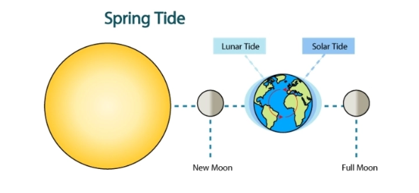
Describe the spring tide
- when the sun and moon are aligned, the gravitational forces combine to create large tidal bulges
- this is a spring tide and it creates the largest possible tidal range.
- a lunar month is 29 days, and every 14/15 days spring tide occurs
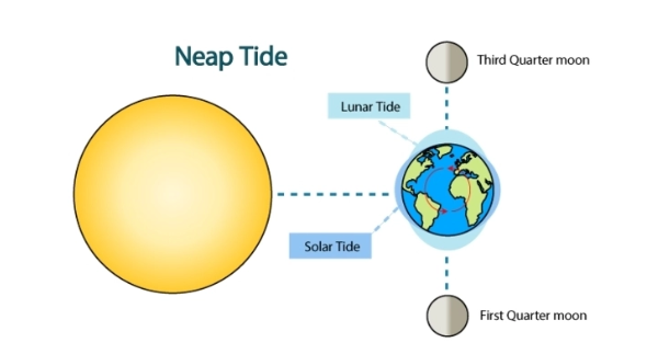
Describe the neap tide
- when the sun and moon are perpendicular to each other, they pull at the sea from different directions
- as the gravitational forces act against each other, the overall pull is minimized and a smaller tidal bulge is created
- this is a neap tide and it creates the smallest possible tidal range.
What is the challenge of the intertidal zone and what are the four subdivisions?
The regular rise and fall in sea level pose enormous challenges and opportunities for the organisms that live in the dynamic space between high and low tides.
- the spray zone is at the top; wetted by the splash of breaking waves but rarely submerged
- the high intertidal zone is underwater only during high tide
- the middle intertidal zone is mostly submerged except for brief periods once or twice a day during low tide
- the lower intertidal zone is only exposed to air during the lowest spring tides
What are the features of high and low energy coastlines?
Low energy coasts:
- waves are not powerful
- often rate of deposition exceeds the rate of erosion
- landforms include beaches and spits
High energy coasts:
- waves are powerful for most of the year
- often rate of erosion exceeds the rate of deposition
- landforms include headlands, cliffs, and wave-cut platforms
Define sediment
Sediment is solid material such as rocks and minerals that are moved and deposited in a new direction.
Define/ describe a sediment cell and a sediment budget
- Sediment cells are generally considered closed systems, suggesting no sediment is transferred from one cell to another.
- Boundaries of sediment cells are determined by coastline topography
- However, it is unlikely these cells are completely closed
A sediment budget is the balance between the inputs and outputs of sediment in the system.
What is sub-aerial weathering?
Sub-aerial weathering is a mass failure caused by non-marine processes such as heavy rain which can cause mass movement of soil at slopes or cliffs.
What is aeolian erosion?
Wind/ Aeolian erosion is the force of the wind that removes loose and unconsolidated material.
Define weathering
Weathering is the breakdown of rocks at the earth’s surface by the action of rainwater.
What is freeze-thaw weathering?
Freeze-thaw: Water enters cracks and freezes as temperatures remain below 0°C. As it freezes the water expands by almost 10%, meaning the ice occupies more space and exerts pressure on the surrounding rock. As the process repeats and continues, the crack widens, and eventually pieces of rock break off.
- this occurs commonly in latitudes where temperature fluctuates frequently above and below freezing, and there is a water supply
What is salt weathering (haloclasty)?
Salt weathering (haloclasty) is the physical changes caused by salt crystallization, salt hydration, or thermal expansion of salts.
Water collects in the cracks of a rock when it rains and when the sun causes the water to evaporate, salt crystals are left behind in the cracks. Overtime, these crystals create stress of the rock and cause it to break up.
What is wetting and drying?
Wetting and drying is when rocks such as shale alternate between being wet, meaning they expand, and dry, meaning they contract. This can create fissures and occur in the intertidal zone.
What is exfoliation?
Exfoliation is the repeated expansion and contraction of rocks, causing fractures, as they heat in the sun and are cooled rapidly by the cold sea.
Occurring in hot climates, the rock expands and exerts an outward pressure during the day when it is warm. At night, the rock cools and so contracts. This repeated contraction and expansion can cause very thin pieces of the rock to flake off.
What is biological weathering?
- roots of vegetation growing into bedding planes or extending into joints ( or animals burrowing into cliffs)
- molluscs and other marine organisms produce secretions which can break down rocks
- water can become acidic by contact with decaying vegetation, increasing chemical weathering
Define solution
Solution is the dissolving of rock minerals such as halite.
Define oxidation
Oxidation causes rocks to disintegrate as they form oxides such as iron oxide.
Define carbonation
Carbonation is when rocks such as chalk and limestone are dissolved by acidic rainwater or seawater, which has absorbed carbon dioxide from the atmosphere to create a weak carbonic acid. This acid converts solid calcium carbonate into solid calcium bicarbonate, meaning it dissolves.
Define hydration
Hydration is a form of chemical weathering in which the chemical bonds of the mineral are changed as it interacts with water.
How does lithology affect rate of erosion?
Coherent rocks have interlocking crystals, strongly cemented particles, and a few lines of weakness.
- They resist erosion and support steep-angled slopes
- Most igneous and metamorphic rocks are highly resistant, as well as some sedimentary rocks such as chalk
Incoherent rocks erode more easily, which can result in low-angled cliff profiles.
- However, weak rocks can be undercut by wave action and fail by slumping, resulting in almost vertical cliff profiles
- Includes sand and clay
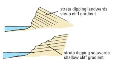
How does rock structure affect erosion
Vertical cliffs develop in horizontally bedded sedimentary rocks (and in volcanic rocks formed from horizontal layers of lava and ash).
- Undercutting by wave action and the collapsing of rock causes the cliff to retreat parallel to itself
Seaward-dipping strata have profiles corresponding to the angle of dip of the bedding planes.
- Loosened rocks, weakened by erosion and weathering, fail along planes and slide into the sea.
- These cliffs are often comprised of more than one rock type
Landward-dipping strata form less steep cliffs, as eroded and weathered rock is not as easily dislodged from the cliff face.
Define mass movement
Mass movement is the movement of weathered particles down slopes under the influence of gravity.
Define shear strength and shear stress
Shear strength is a measure of the resistance of earth materials to be moved.
Shear stress is the force exerted by the weight of the material under the influence of gravity acting in the down-slope direction.
How does soil creep work?
Common in humid climates, it is the slowest type of mass movement, at a rate of less than 1 cm per year. It has a slope angle of 5 degrees.
Soil expands when it freezes, gets wet or is heated in the sun. As it expands, it lifts at right angles to the slope. When the soil shrinks again, it falls straight back down, therefore landing slightly further down the slope. This takes a long time because the soil moves only a millimetre to a few centimetres at a time.
Indicators include: bent tree trunks, bulges/breaks in dry stone walls, and tension gashes in roads.
How does solifluction work?
A gradual process in which a mass moves down a slope, related to freeze-thaw weathering.
How does earth flow work?
A flow movement caused by the earth at the top becomes saturated with water. It has a rate of 1-15km per year and slopes of 5 - 15 degrees. This creates flow tracks, tongues, and lobes.
How does mudflow work?
A flow movement that is more rapid than an earth flow and steeper slopes. It can move 1 km per hour. It occurs after intense rainfall, which adds volume and weight to the soil. Vegetation is flattened and carried away with the soil.
How does rockfall work?
Spontaneous movements on slopes greater than 40 degrees, form scree at the foot of the slope with the largest boulders at the base.
They can be caused due to:
- extreme weathering that loosen rocks until they collapse
- rainfall which softens the surface of a slope until it collapses
- earthquakes which dislodge unstable rocks
- hot weather which dries out the soil, causing it to shrink and allowing the embedded rocks to fall
How does rotational slumping work?
A rapid movement with a curved rupture surface. Softer materials, such as clay or sand, overlie more resistant or impermeable rocks, such as limestone or granite.
Precipitation permeates through permeable layers and creates a slip plane above impermeable rock. The sea erodes the permeable rock at the bottom, and as this erodes the layers of permeable rock above slump downwards from the point of weakness onward as they are unsupported.
Cliffs slump at points of weakness, caused by biological ingress such as roots.
Define hydraulic action
Hydraulic action is erosion by the force of waves against the coastline.
Define wave quarrying
Wave quarrying is the erosion of cliffs by high-energy, tall waves that have the power to remove large chunks of rock.
Define wave pounding
Wave pounding is when waves hit the foot of cliffs or sea walls, generating shock waves of up to 30 tonnes per m^2.
Define abrasion/ corrosion
Abrasion/corrosion is a ‘sandpaper effect’ when breaking waves containing sand and other sediment wear away at the base of a cliff.
Define cavitation
Cavitation is the compression of air in sea-facing joints as waves crash against cliffs. When air bubbles implode, shock waves are generated and weaken the rock.
Define solution
Solution is corrosion by acids in the seawater against the rock.
Define attrition
Attrition is when sediment carried by the waves hits each other, reducing their size and making them smoother.
Describe traction
Traction is when pebbles are rolled along the seabed by the force of the waves/ current.
Describe suspension
Suspension is when small materials such as clay and silt are carried in the flow of the sea water.
Describe longshore drift
Longshore(littoral) drift is the main process of deposition and transportation along the coast. Influenced by the prevailing wind, waves approach the beach at an angle. When the waves break, the swash carries material up the beach at the same angle and backwash carries the material back down the beach at a reflected right angle from the angle it entered. The process repeats, transporting material down the beach in a zig-zag movement.
Describe a concordant coastlline
A concordant coastline occurs where bands of differing rock types run parallel to the coast, and the outer hard rock provides a protective barrier to the erosion of soft rocks.
Define a cove
A cove is a circular area of water with a relatively narrow entrance way from the sea.
Describe a discordant coastline
A discordant coastline is when the geology alternates between strata of hard and soft rock.
Explain the formation of headlands and bays
Alternating more or less resistant rocks are a common feature of many coastlines. In discordant coastlines, erosional processes will initially erode the areas with less resistant rocks, forming bays. Therefore, the more resistant rocks sticks out as bays.
Refraction means that the headlands will then experience higher energy waves, and so is more vulnerable to erosion.
Bays experience low-energy waves, allowing sediment to accumulate and form beaches, which can then further protect the coastline
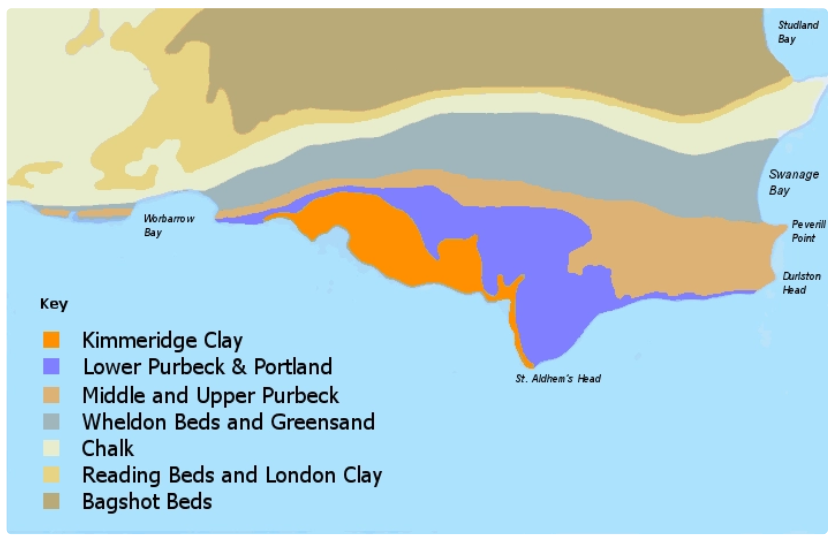
Give and describe the local case study for headlands and bays
Jurassic coast in Dorset
- Wheldon beds and greensand geology is less resistant that Kimmeridge clay and Lower Purbeck and Portland geology
- this creates bays such as Warbarrow bay and Swanage Bay, and headlands such as St Aldehm’s head
Give and describe a global case study for headlands and bays
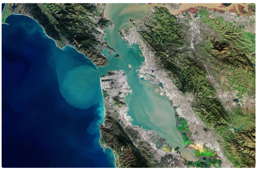
Concordant coast of San Francisco Bay
- over 10,000 years, sea-level rise has inundated a series of valley’s running parallel to the coastline, creating a concordant coastline which allows for the creation of bays and headlands
- once parts with less hard rock erode their hard rock first, the lower -down soft rock behind erodes quicker than the hard rock in front
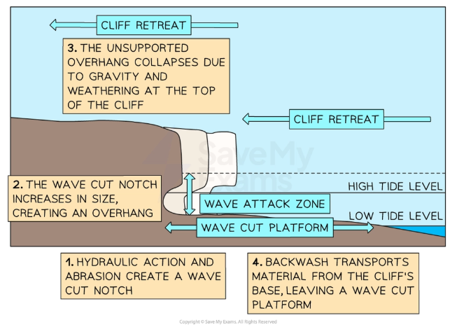
Explain the formation of cliffs and wave-cut platforms
A wave-cut platform is a gently sloping, relatively smooth, marine platform caused by abrasion at the base of the cliff.
The energy and corrosive action of waves are concentrated onto the rockface between low tide and high tide, creating a wave cut notch. Further erosion increases stress on the cliff above, and so the unsupported cliff above eventually collapses, and is transported away via the backwash of waves.
As the platform continues to grow, waves have to travel further along thee wave-cut platform before reaching the base of the cliff. Therefore, energy is dissipated more and the rate of erosion is reduced. This means there is a limit to how far a wave-cut platform can grow (about 0.5km usually).
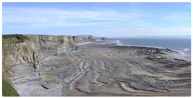
Give and describe a local case study for cliffs and wavecut platforms
Southern down, South Wales
In the last 200 million years, earth movements creating folding and fracturing of rocks. High waters mostly since the end of the last Ice Age has meant the present coastline resumes a fast pace of erosion, creating a long wave-cut platform
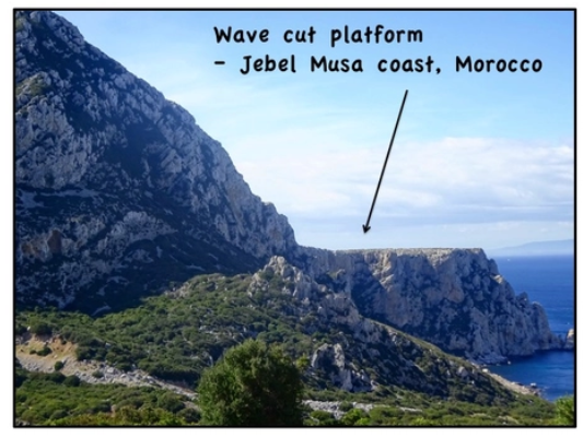
Give and describe a global case study for cliffs and wavecut platforms
Jebel Musa coast, Morocco
This shows a wave-cut platform 50m above current sea-level because of mountain rise due to the Africa- Eurasia plate convergence.
Explain the formation of geos, caves, blowholes, arches, stacks and stumps
Geo:
A geo is an inlet, a gully or long narrow steep-sided cliff formed by erosion in coastal cliffs.
They are common on the Orkney and Shetland Islands.
Cave:
Hydraulic action creates a large crack in the cliff-face, and further erosion via wave pounding, hydraulic pressure and abrasion both vertically and laterally create a cave.
Blowhole:
The water in the cave can create pressure, creating cracks throughout the rock towards the surface. Vertical marine erosion and sub-aerial weathering creates a shaft to the surface/ collapse of overlying rocks, known as a blowhole.
Arches:
Rather than a blowhole, it is more likely that, if a cave is on a headland (which experiences more erosional processes due to refraction), it will continue to erode into the rock backwards and meet another cave on the other side. The two conjoining caves create a hole all the way through the headland, known as an arch.
Stacks:
As the headland continues to erode, the top of the arch will eventually collapse due to gravity. This leaves a tall, isolated portion of rock known as a stack.
Stump:
Overtime, the erosion of the wave-cut notch within the stack will lead to rock above the notch collapsing, and a small stump may be left.
Give and describe a local case study for geos, caves, blowholes, arches, stacks and stumps
Old Harry’s Rocks, Dorset, England
The chalk of Old Harry Rocks used to be part of a long stretch of chalk between Purbeck and the Isle of Wight, but remained as a headland after large parts of this seam were eroded away.
Hydraulic action towards to headland resulting in enlarging cracks, then caves, then arches. The arches collapsed after being weakened by rainfall and wind, leaving disconnected stacks.
One of these stack’s is known as Old Harry, and Old Harry’s wife was another stack which has now become a stump due to corrosion. Hydraulic action then eroded the stump away.

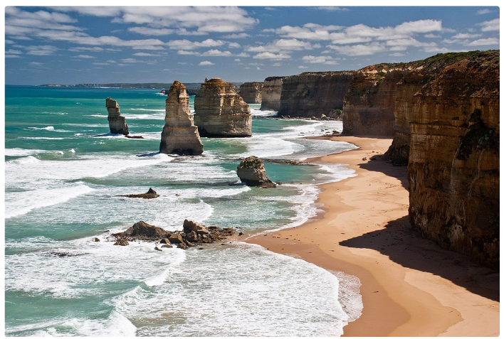
Give and describe a global case study for geos, caves, stacks and stumps
Twelve Apostles, Victoria, Australia
This is a constantly changing and evolving landscape. The rate of erosion at the base of the limestone pillars is approximately 2 cm per year, and existing headlands are expected to become new limestone stack in the future due to erosion from wave action.
Describe a beach
A beach is a landform of coastal deposition that lies between high tide and low tide lines composed of eroded material that has been transported and deposited.
How are ridges and runnels formed in the sand at a beach?
Sand becomes very compact when wet, and so allows very little percolation. This means that most of the swash returns as backwash, which creates ridges and runnels in the sand at the low-water mark that run parallel to the shore and are broken by channels which drain water back to the sea.
How to cusps form on a beach?
Semi-circular depressions may appear at the seam between the sand and shingle beach, known as cusps, which represents where waves have broke directly on to the beach.
How does shingle affect a beach?
Shingle can make up all or the top part of a beach. It is larger than sand, so compacts less than sand. This means water percolated a lot easier, limiting how much sediment can return as backwash.
What are berms?
Beyond the shingle are a series of ridges leading up to the storm beach, marking different high tides through the tidal cycle; these are known as berms.
How does a storm beach differ from a regular beach?
At the back of the beach, strong swash at high tide will create a storm beach. A storm beach is composed of the largest boulders thrown by the largest waves at high tide (when the waves have the most energy).
What are the features of a swash-aligned beach?
- generally orientated parallel to incoming waves crests
- experience minimal longshore drift
- found on irregular coastlines where longshore drift is impeded and waves hit sections of the coast head-on
What are the features of a drift-aligned beach?
- generally orientated parallel to direction of dominant longshore drift
- considerable amounts of sediment which has been transported long distances
- initially where a coastline is fairly regular, or where the predominant wave direction is at an angle to the beach
- can extend out from the coastline ( a spit) when there us a sudden change in the direction of the coastline
- equilibrium; without a continual supply of sediment to the beach, longshore drift would remove the sediment faster than it was deposited
Give and describe a local case study for beaches
Hornsea Beach, East Riding of Yorkshire
Hornsea beach is a 2.9km stretch of beach fronting the town of Hornsea on the Holderness Coast between Bridlington and Withernsea.
- Hornsea lies upon boulder clay, which is unconsolidated till deposited by glaciers during the last ice age 18,000 years ago
- groynes ensure wide and relatively steep beaches
- cliffs consist of soft boulder clay, which erodes rapidly due to destructive waves brought by north-easterly winds (particularly in the winter)
Give and describe a global case study for a beach
Long beach, Tofino, Vancouver Island
A 16km stretch of sandy coastline, bordered by temperate rainforests and rocky headlands. It is part of the Pacific Rim National Park reserve on the Western side of Vancouver Island
- shaped by high- energy waves
- sediment derived from rivers and coastal erosional processes
- benefits from prevailing westerly winds and wave action, which drives sediment onto the beach
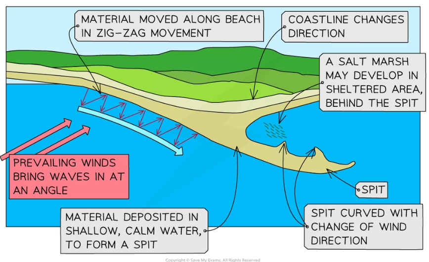
Explain the formation of a spit
A spit is an elongated, narrow ridge of land that has one end joined to the mainland and projects out into the sea or across an estuary, usually on drift-aligned coasts.
They form where there is a sudden change in the direction of a coastline.
Spits are composed of sand and/ or shingle, dependent in availability of material and wave energy.
1. Longshore drift carries material along the beach in one direction, dependent on the angle of prevailing winds
2. Sand and shingle deposit around the headland/ where the beach changes direction- rather than ‘bending’ around the coastline- due to loss in water’s energy
3. Material will eventually build up above the high water mark, especially during storms
4. Finer material can be carried further along the spit until the water loses energy and deposits it, extending the spit
5. Ends of the spit can curve due to wave refraction, carrying material into more sheltered water
6. Deep water, limited carrying capacity of water, or the flow from a river at an estuary may limit a spit from growing any further
Give and describe the different types of spits
A simple spit is either straight or recurved, but does not have any minor spits or recurved ridges along their landward edges.
A compound spit can be similar to a simple spit, but has a number of recurved ridges or minor spits along their landward ridges (possibly marking the position where they terminated in the past).
How can spits lead to the development of other coastal landforms?
Sand dunes can develop in the sheltered water on the landward side of the spit. As deposited sand dries out and is blown onto the landward side of the spit by prevailing winds, it can accumulate and become stabilised by vegetation.
Salt marshes can also develop as low-energy waves enter the sheltered area and deposit finer material such as silt and clay, which is then colonised by vegetation.
Give and describe a local case study for a spit
Spurn Point, East Riding of Yorkshire
Spurn Point forms the southern end of the Holderness coast; it is a 5.5km long spit made from sand and shingle which reached across the Humber estuary.
- composed of material which has been transported along the Holderness coast, the fastest eroding coastline in Europe
- forms a sweeping curve continuing the line of the coast
- waves energy reduces where the North Sea meets the Humber Estuary, causing the material to be deposited
- sand dunes have formed and colonised by mainly mahram grass
- a salt marsh has formed in the low energy environment created by the spit
- Spurn Point was breached during a storm surge in December 2013, destroying parts of the sand dune
Give and describe a global case study for a spit
Farewell spit, South Island, New Zealand
Farewell spit, New Zealand’s longest sandspit (25km long) lies on the Northern tip of the
- in times of flood, rivers flowing from the Southern Alps release suspended sediments into the Tasman sea, which is swept northwards by the Westland current to the tip of south island, where the current loses energy and deposits the sediment
- at least 3.4 million cubic metres of material is added to the spit each year
- sand dunes, known as barchan dunes, have been blown in by changing winds
- the spit began building 14,000 years ago at the end of the last ice age
- once a vast sandplain connected the Golden Bat to the Wanganui/ Manawatu area
- Farewell spit is home to over 90 species of birds
Explain the formation of a tombolo
A tombolo is a spit that joins an island to the mainland.
- the island blocks and slows down water movement, causing it to lose energy and deposit material in between the island and the mainland
Give and describe a local case study for a tombolo
Chesil Beach, Dorset, England
An 18-mile long pebble tombolo aligned almost parallel to the coastline connecting the mainland with the Isle of Portland.
- formed over the past 10,000 to 15,000 years in the Late Pleistocene era
- part of the Jurassic coast
- subjected to strong wave action, allowing large pebbles to be deposited
Give and describe a global case study for tombolos
The Aupouri Peninsula is located on the northern side of the North island, between the Tasman Sea and the Pacific Ocean. It is 75km long by approximately 10km wide tombolo which connects the mainland to North Cape.
- ocean currents move sand northwards along the Aupouri peninsula coast
- strong prevailing westerly winds form dunes on the inside,
- some former dunes have become pine forests
Explain the formation of offshore bars
An offshore bar is a long, narrow ridge of deposited materials such as sand which can be found lying away from and parallel to a coast.
They are almost always submerged underwater, by may be exposed by neap tides
1. Sediment is eroded by destructive waves and carried in a seaward direction by the backwash
2. Friction of the sea bed causes approaching waves to break at the boundary of the nearshore and offshore zones
3. Overtime, sediment builds up parallel to the coast to form a ridge of sand called an offshore bar
- offshore bars reduce wave energy before the waves reach the shore
- the difference between offshore bars and barrier beaches is that barrier beaches are almost always visible, as they are above the HWM, where as offshore bars are below the LWM
Explain the formation of barrier beaches and islands
A barrier beach is an elongated bank of deposited sand or shingle lying parallel to the coastline
- when the bank is high enough to allow sand dunes to develop, it is known as a barrier island.
- often the sheltered area between the barrier beach and land becomes a lagoon or a marsh (this could also be a mangrove swamp in more tropical climates)
There are two types of barrier islands- wave dominated and mixed energy
- wave dominated barrier islands are long, low and narrow and more susceptible to being breached by storms
- these barrier islands require a constant supply of sediment to grow and develop dunes
- wave dominated barrier islands eventually become mixed energy barrier islands, shaped by both wave energy and tidal flux
Give and describe a local case study of barrier beaches and islands
Loe bar, Cornwall
Loe bar is a shingle barrier beach which separates Loe pool from the sea on the South east of Cornwall.
- it is mostly made of flints, even though this rock is not local
- this originated as an offshore bar when sea level were much lower during the ice age
- as sea levels rose over time, the flints in the offshore bar were moved inshore and deposited as a beach
- this means the position of the ridge has migrated inland
Give and describe a global case study for barrier beaches and islands
Outer banks, North Carolina
The outer banks are a string of barrier islands that begin at the Virginia border and go south for around 120 miles to Ocracoke island.
- 14,000 to 18,000 years ago, glaciers began to melt and cause sea levels to melt. Water broke through what was previously dunes, separating the dune line as a string of islands
- sea level rise slowed, allowing sediment deposited by longshore drift or river systems to grow the islands
- spits can eventually connect to the island
- protects the mainland from storms and tides
Explain the formation of sand dunes
Sand dunes are accumulations of sand that are shaped into mounds by the wind.
They require a good supply of sand, strong onshore winds and a large tidal range. They also need an obstacle to trap the sand and vegetation to encourage further growth of the dune.
Saltation moves sand inland; wind, and therefore the sand, moves towards the slightly lower atmospheric pressure over land (as air is warmed when it moves over the warmer land). Where there is a large tidal range, large amounts of sand are exposed at low tide.
1. Dry sediment is blown inland and deposited above the high tide mark
2. Larger sediment particles become trapped against an obstacle, forming a ridge
3. Sediment builds up to form a crest, which then may collapse as it becomes to tall, creating small ridges as the previous ridge becomes an obstacle
4. The first dunes to develop are known as embryonic dunes, and they are suitable for colonization by grasses which grow upwards, trapping more sand and stabilizing the surface. Long roots underground also help to stabilize the dunes and added organic matter aids water retention
5. Foredunes (mobile dunes) are created when dunes increase in height so that they are beyond but the highest storm tides- up to 20m high in some places. As vegetation cover increases and humus is added, they start to appear grey rather than yellow.
6. Dunes eventually become fixed as an organic layer develops and other vegetation is introduced
- ‘dune slacks’ are depressions within the dunes where the water table is near the surface, creating damp conditions
7. Behind these dunes the supply of sand is eventually cut off, giving smaller features- these can be called wasting dunes
- ‘blowouts’ can be found in this system, showing where wind has funneled through and removed sand. Animals and humans can often be catalysts for this to happen.
Give and describe a local case study for sand dunes
Fylde Sand dunes, Blackpool
The dunes act as a natural barrier to the sea at high tide, and release sand during storm conditions to reduce wave action.
The dunes support a variety of wildlife, such as 150 species of butterflies and moths
In conservation efforts, Christmas trees are recycled and used to trap sand particles, forming new embryo dunes.
Give and describe a global case study for sand dunes
Mount Tempest, Moreton, Australia
At 285 meters above sea level, Mt Tempest is thought to be the tallest sand dune in the world. They were formed during the Pleistocene.
Due to Australia being a relatively isolated island, it has a large tidal range.
Define an estuary
An estuary is the open mouth of a river where it meets the sea.