Coastal Risk, Management and Mitigation
1/19
There's no tags or description
Looks like no tags are added yet.
Name | Mastery | Learn | Test | Matching | Spaced | Call with Kai |
|---|
No analytics yet
Send a link to your students to track their progress
20 Terms
How much has people living in near-coastal zones increased
In 1990, ~1.2 billion people lived in the near-coastal zone (within 100 km from the coast). By 2010, increased to ~1.9 billion; and 2020, increased further to 2.15 billion

Examples where coastal landscapes have been modified for agriculture, resources & industry
-Rice terraces, Japan
-Shrimp farming, Indonesia
-Sand mining, South Africa
-Container Port, China
The Emergency Events Database (EM-DAT)
Initiative between the Centre for Research on the Epidemiology of Disasters (CRED) and the World Health Organization (WHO) that indicates that between 2020 and 2025 (globally) natural disasters including impacts from storms, storm surge, tornados, and cyclones have had the following impacts:
• Number affected - 704,277,788
• Number of deaths - 286,196
• $1,093,930,454,000 (USD)
Examples of large scale natural disasters
-Hurricane Katrina (New Orleans, 2005)
-Typhoon Fung-wong (Philippines, 2025)
-North Sea Storm Surge (England, 1953)
-Japanese Tsunami (2011)
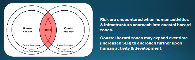
Coastal Risk Management
Risks associated with increasing coastal development coupled with the impacts from climate change requires an improved understanding of the complex interactions between human activities & coastal processes to help secure a more sustainable future for coastal communities
Risk
A combination of the probability of the hazard occurring and the potential impacts
Probability
The likelihood of a hazard occurring
Severity
Depends on the magnitude of the hazard and the vulnerability of the area affected
Magnitude
Affects its potential to cause damage and will be influenced by factors such as:
• Flood water depth, velocity & rate of flooding
• Flood duration
• Wave action
• Tidal state
• Meteorological conditions (storm surge)
Vulnerability
Affects the potential for damage and will be influenced by factors such as:
• Elevation of land
• Existence/lack of (suitable) coastal defence infrastructure
• Number of properties and/or size of area affected
• Nature of development e.g. residential, commercial industrial, recreation
• Approach to construction
• Presence of early warning systems
• Presence and reliability of mitigation measures (warnings, evacuation plan, defences etc.)
• Build back better
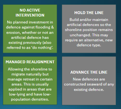
Shoreline Management Plans (SMPs)
Non-statutory policy documents that identify a sustainable approach for managing the risk of coastal flooding & erosion over the short (0 to 20 years), medium (20 to 50 years) and long (50 to 100) term. They are a decision-making tool to help inform coastal managers and planners on pathways for future coastal management
Hard Engineering (+ examples)
Approaches that are usually structural to control/limit processes
Hard engineering options include:
• Seawalls and rock revetments (reduce wave overtopping)
• Cliff protection and stabilisation (prevents collapse)
• Groynes (traps sediment)
Soft Engineering (+ examples)
Approaches are designed to work with nature by manipulating natural systems to provide defence against current & future wave impacts and sea level rise. Widely referred to as Nature-based Solutions (NbS).
Hard engineering options include:
• Saltmarsh and mudflat management
• Beach nourishment
• Sand dune management
Managed Realignment (saltmarsh and mudflat management)
The removal of existing defences allowing an area to become inundated with the tide, usually results in the creation of mudflats & saltmarsh. It helps address sea level rise & coastal erosion without the need for hard coastal defences - relies on natural defences to absorb wave energy. Intertidal habitat creation provides multiple benefits, improving biodiversity & water quality, aids carbon sequestration, flood alleviation and amenity for local communities. However, it can face local opposition and a protracted planning process
Dredged Sediment
Dredging is a vital socio-economic activity needed to maintain safe navigation for shipping that access UK ports, harbours & marinas. Dredged material can be used to reshape shorelines, restore habitats, providing the conditions to aid ecological recovery, or slow habitat decline allowing time for other coastal adaptation measures to be implemented
Beach Nourishment
Sediment lost via longshore drift & erosion is replaced to maintain “natural” beach form. Sediment is imported (often by dredger) then rainbowed or pumped onshore
Beach Recycling and Reprofiling
Shingle is taken from an area of accretion and moved to an area of erosion, maintaining beach profile and reduces wave overtopping.
Reprofiling moves sediment from the lower part of the beach to the upper. Helps create a natural (more dissipative) slope angle and restores the beach crest
Dune Management
Dune restoration projects usually integrate vegetation efforts with natural, sustainable, and soft solutions to stabilise the dune system. Aims to work with natural processes (e.g., wind) to trap wind-blown sand increasing resilience to storm waves and sea level rise. Management measures can lead to overstabilisation and sediment starvation reducing the dynamic nature and evolution of the dune system. A need to increase bare sand coverage is filled by notch creation, dune slack turf & topsoil removal
Reefs
Coral reefs act as critical natural infrastructure for managing coastlines, functioning as submerged breakwaters that protect against flooding and erosion. We find evidence for the role of reefs in mitigating shoreline erosion during storm events, with coral reef-protected beaches experiencing 97 % less beach volume loss than unprotected beaches. They however have a low effect towards flooding, wave attenuation and sediment/geomorphology.
Kelp (+ submerged aquatic vegetation)
Kelp forests alter the movement of water and can provide a buffer against storm surges by reducing wave energy. Used as a habitat by baby fish to hide from predators before they grow to their adult size, and potentially cut wave height by up to 70% in some areas. They however have a low effect towards flooding, wave attenuation and sediment/geomorphology.