Glacial Systems and Landscapes
1/147
There's no tags or description
Looks like no tags are added yet.
Name | Mastery | Learn | Test | Matching | Spaced | Call with Kai |
|---|
No analytics yet
Send a link to your students to track their progress
148 Terms
Natural system
Natural systems have inputs, outputs and processes that transform inputs and lead to outputs.
Inputs of glacial systems
Snow from precipitation or avalanches.
Condensation/sublimation of water vapour.
Bits of rock collected from plucking.
Outputs of glacial systems
Ice melts and flows out as meltwater.
Snow melts, evaporates or is blown away by wind.
Ice and snow can sublimate to water vapour.
Blocks of ice fall from the snout to form icebergs.
Stores of glacial systems
Mainly ice.
Meltwater and rock.
Flows in glacial systems
Meltwater and debris flow through glaciers.
Glacial budget (mass balance)
The balance between a glaciers inputs and outputs.
The balance between accumulation and ablation over a year.
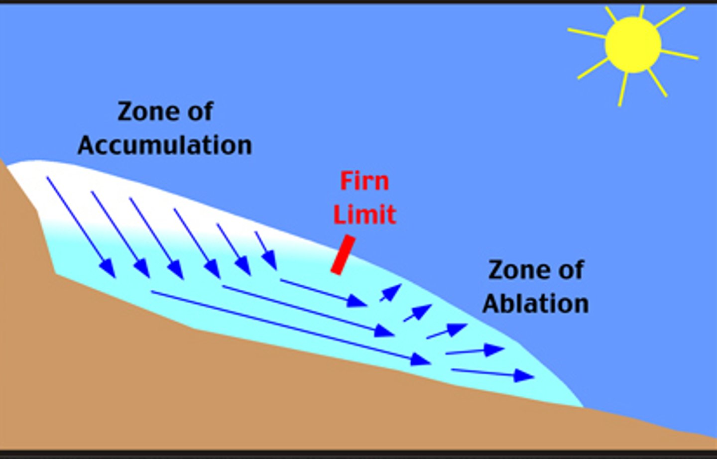
Accumulation
The input of snow and ice into the glacial system (mostly snow).
Ablation
The output of water from a glacier.
Positive regime/mass balance
More accumulation than ablation over a year. Glacier grows and advances in response to high accumulation in upper zone.
Negative regime/mass balance
Less accumulation than ablation over a year. Glacier shrinks and retreats in response to low accumulation in upper zone.
Dynamic equilibrium
When a system stays the same on average. When there's the same amount of accumulation and ablation over a year. The glacier stays the same size and the position of the snout doesn't change.
Change of glacial budgets throughout the year
More ablation occurs during warmer seasons.
More accumulation occurs during colder months.
This can balance out over the year.
The glacier advances in winter but retreats in summer so the overall mass remains the same.
Change of glacial budgets over many years
There's variation in the glacial budget year to year.
Even if the overall trend is for retreat, some years there may be advances due to more accumulation and less ablation than usual (and vice versa).
Change of glacial budgets over hundreds of years
Temperatures in the Little Ice Age were colder than the periods before and after it, many glaciers advanced because they had a positive regime.
Since 1850 global temperatures have increased, glaciers have tended to have a negative regime and retreated.
Little Ice Age
Period of colder temperatures and glacial growth between 1550 and 1850.
Feedback loops
When inputs or outputs change there can be negative feedbacks. If the size of the ice input increases, a glacier may speed up so that more water and ice are output and the mass of the glacier remains constant.
Positive feedback loop
Responding to change in a way that makes the change greater.
How glaciers have a positive feedback loop
Ice has a high albedo, it reflects a lot of the sun's energy. If glaciers retreat there is less ice so less of the sun's energy is reflected and more is absorbed, temperatures rise and glaciers retreat further.
Historical patterns of ice advance and retreat
Melting is happening on a global scale at a faster rate than before. In 2015, observed glaciers lost 0.5m of ice thickness every year. Recent periods of readvancement do not come close to reaching maximum positions of the Little Ice Age. World's glaciers expected to continue rate of melt if climate remains stable. If it continues to warm there will be further glacier losses.
Pleistocene glaciation
Fluctuations in global temperatures led to colder glacials and warmer interglacials. Last glacial maximum was 21,000 years ago, cold environments then extended further then they do today. Polar ice sheets covered much of UK and most of southern Europe was periglacial.
Period of Pleistocene glaciation
Lasted from 2.5 million years ago to 11,700 years ago.
Last glacial maximum
21,000 years ago
Glacial periods
During glacial periods glaciers advance and sea levels fall.
Interglacial periods
During interglacial periods ice retreats and sea levels rise. We are currently in an interglacial.
Where glacial environments are found globally
In polar and alpine settings.
Where polar environments are found globally
The Arctic circle, 66°N.
The 10°C July isotherm.
The 10°C January isotherm.
Where alpine environments are found globally
At high altitudes at any latitude.
Where periglacial (tundra) environments are found globally
At high altitudes and high latitudes.
Around ice masses in mountain ranges in northern parts of Asia, North America and Europe.
Glacial environments
Glacial environments are areas of land permanently covered by ice, this can be glaciers or ice sheets
Climate of glacial environments
Cold enough for ice to be present all year round.
May be warm enough for meltwater to affect glaciers in summer.
Most have high snowfall, but not all.
Soil of glacial environments
Covered by ice permanently so there's no exposed soil.
Vegetation of glacial environments
Very few plants, algae and moss can grow on the glacier surface during summer.
Polar environments
Surround the poles. Land-based polar environments can include glacial and periglacial ones.
Climate of polar environments
Very cold, temperatures rarely above 10°C.
Winters normally below -40°C and can reach -90°C.
Precipitation is low, no more than 100mm a year.
Defined seasons: cold summers and colder winters.
Vegetation of polar environments
Very few plants, lichen and mosses are found on rocks, grasses are found in warmer areas.
Soil of polar environments
Much of the ground covered by ice. Exposed soil is thin and nutrient-poor. There's permafrost beneath the soil.
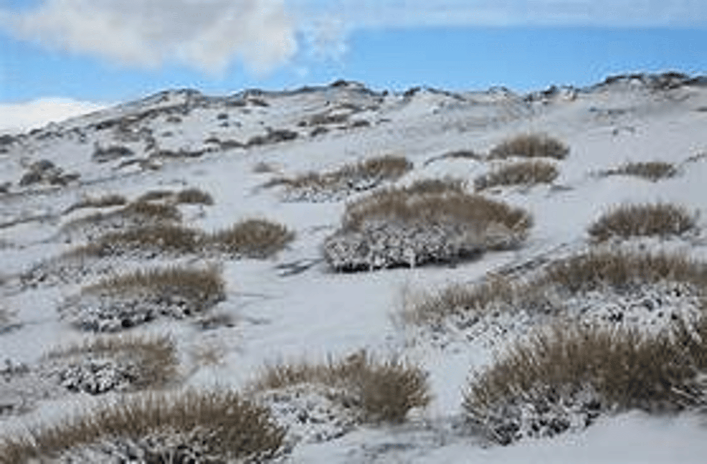
Periglacial (tundra) environments
Places where temperature is frequently or constantly below freezing but are not covered by ice.
Climate of periglacial environments
Cold with low precipitation, less than 400mm a year.
Defined seasons: brief, mild summers and long, cold winters.
Soil of periglacial environments
Thin, acidic and not very fertile. Usually a permafrost layer topped with a layer that thaws in summer (the active layer).
Vegetation of periglacial environments
Plants grow slowly and don't grow very tall. Grasses are the most common. Some small trees can grow in sheltered areas. Only mosses and lichen can survive near the poles.
Alpine environments
Cold areas of land at an altitude above the treeline (mountainous). They can include glacial conditions at higher altitudes and periglacial ones at lower altitudes.
Climate of alpine environments
Winters are cold but summers can be mild.
Temperature increases as altitude does.
Snowfall can be high.
Soil of alpine environments
When ice melts in summer, soil is exposed in some areas. Higher up, land is permanently covered by snow and ice. Lower down periglacial soils are present.
Vegetation of alpine environments
Seasonally exposed soils means that plants such as grasses and alpine flowers can grow.
Tundra vegetation adaptations
Hug the ground to avoid low temperatures.
Slow growth rates.
Shallow roots.
Reduced transpiration due to small leaves and thick cuticles and low albedo to absorb radiation.
Tundra soil characteristics
Formation is slow, they have little organic matter and few decomposers.
Active layer is acidic, thin, saturated and boggy as permafrost prevents drainage.
Uniform blue/grey colour.
Pressure melting point
The point at which enough pressure is applied to cause melting of glacier ice
Cold based glaciers (polar)
High latitude locations.
Basal temperatures below pressure melting point.
Very slow rates of movement.
Low relief.
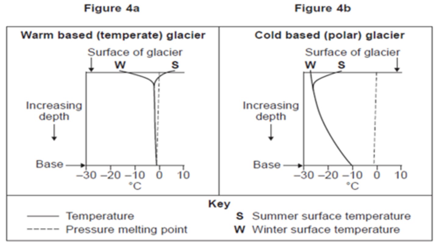
Warm based glaciers (temperate)
High altitude locations.
Basal temperatures at or near pressure melting point.
Rapid rates of movement, 20-200m per year.
Steep relief

Geomorphological (weathering) processes
Frost action (freeze-thaw) and nivation
Frost action (freeze-thaw)
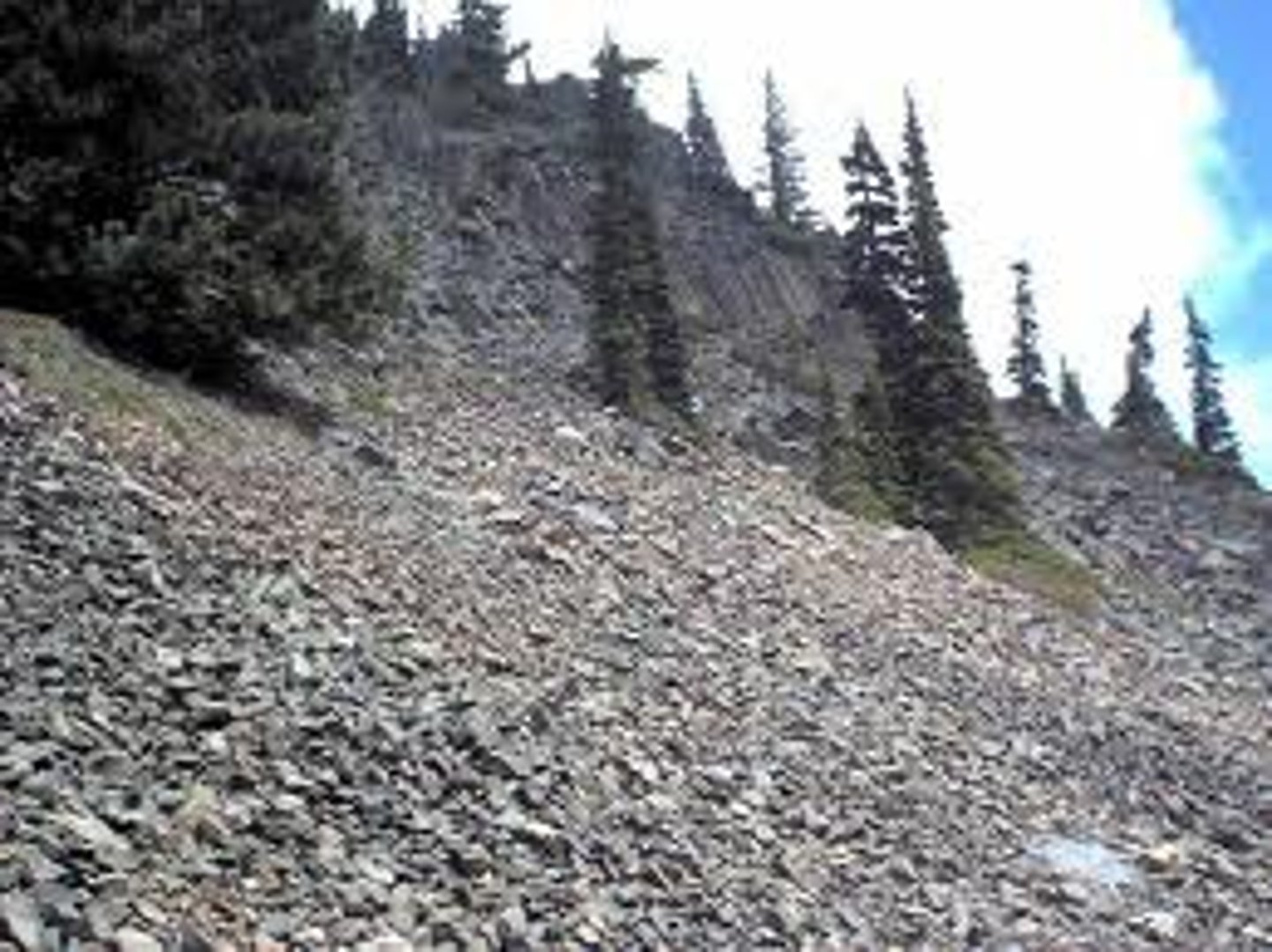
Water enters the joints and crevices in rocks and cliff faces. When temperature drops below 0°C the water freezes and expands. This happens repeatedly and weakens the rocks and causes pieces to fall off. This can form a scree.
Scree
A collection of broken rock fragments at the base of mountains.
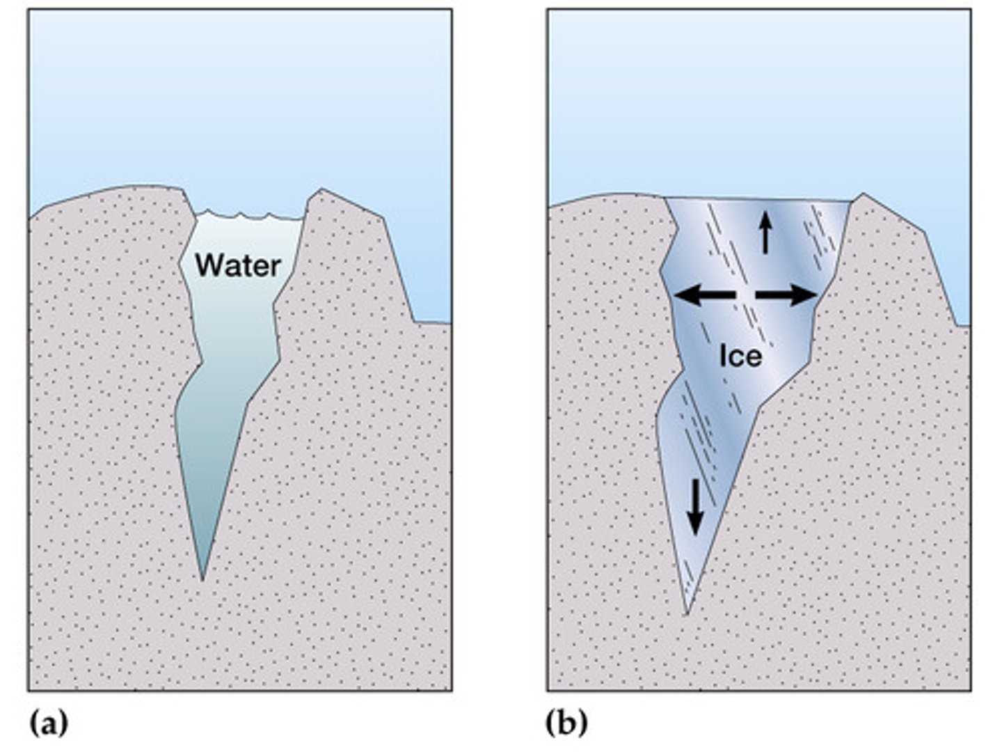
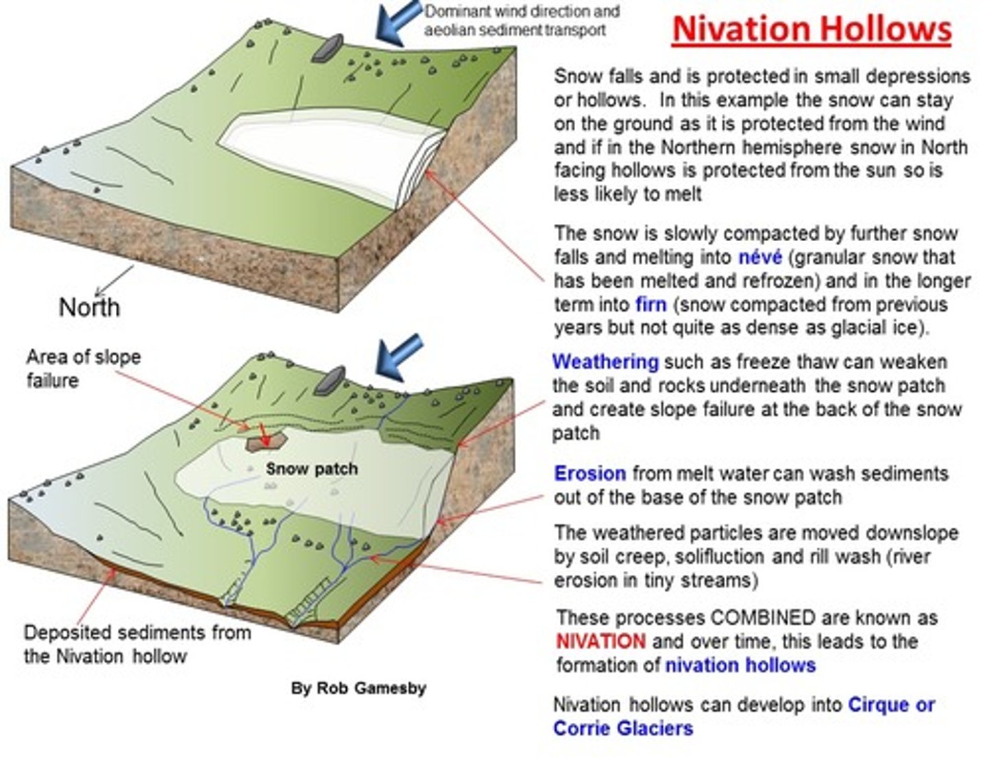
Nivation
When snow makes hollows deeper and wider by freezing and thawing.
When temperature is above 0°C the snow melts and when it's below °C the water refreezes as ice.
Ice expands as it freezes, frost shattering breaks off bits of the rock at the base of the hollow.
When the snow melts the melt water carries the debris away.
Erosion processes
Plucking. Abrasion. Transportation. Deposition.
Factors which affect rate of erosion
Resistance of rock.
Thickness of glacier.
Rate of glacial movement.
Amount of debris.
Resistance of debris.
Plucking
Ice in contact with rock surfaces can thaw slightly then refreeze around rocks protruding from the valley sides and floor.
When the glacier moves forward it plucks the rocks away from the valley sides and floor.
Abrasion
Debris carried along by the glacier can scrape material off the valley walls and floor.
Transportation
Glaciers carry large loads of debris, material that the glacier has gathered by plucking or bits of rock that have been broken off the back wall or valley sides and fallen onto the glacier.
Deposition
Glaciers deposit their load as they move and melt. The unsorted material deposited by the glacier is called till.
Lodgement till
Till spread onto the valley floor beneath the ice by moving glaciers.
Ablation till
Till dropped by a glacier as it melts, mainly deposited close to the glacier snout because this is where most ablation happens.
Internal deformation
When ice bends and warps to flow downhill like a liquid, caused by ice crystals shifting past each other.
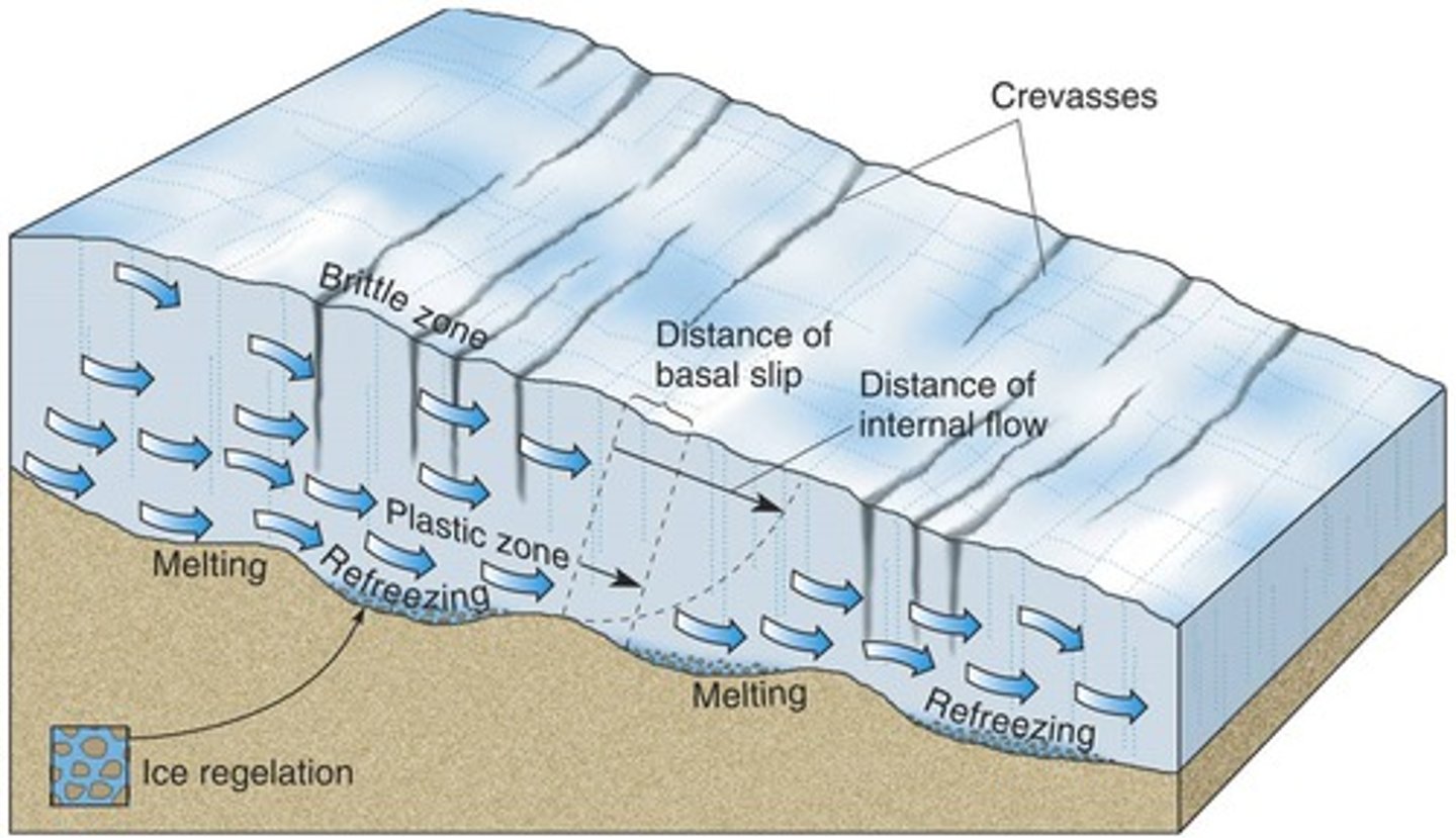
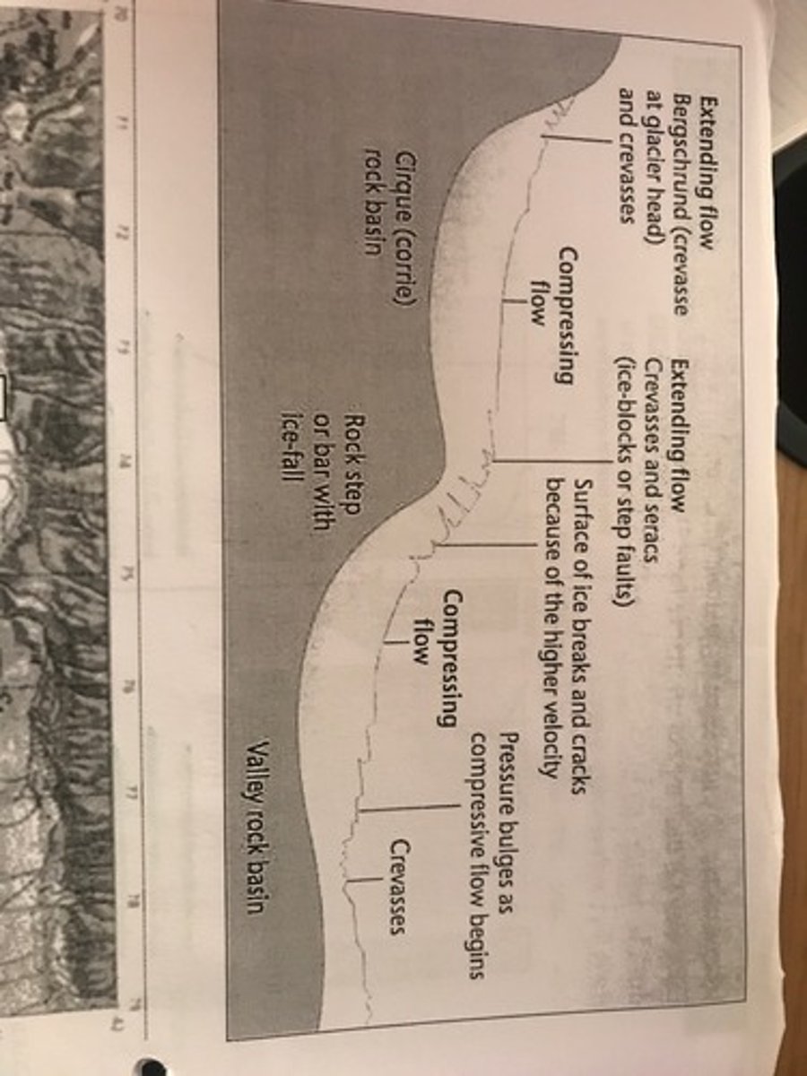
Extensional flow
When ice moves quickly there's more tension, this causes the ice to fracture into thick layers which then slip downwards. This creates crevasses. Occurs at the head of the glacier
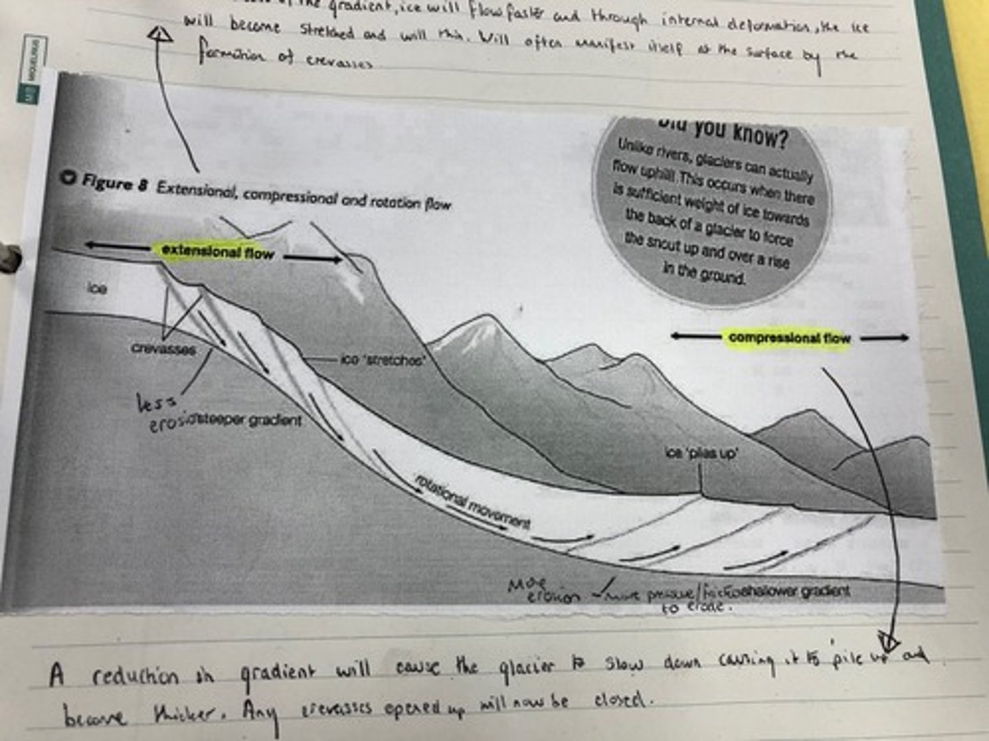
Compressional flow
Lower down the glacier the ice is moving more slowly.
The faster ice from the head pushes down on the slower ice and compresses it. The high pressure causes the ice to fracture into layers and the layers slip forwards. This results in thrusting up of ice blocks along faults.
Basal sliding
As a glacier moves it will exert pressure and melting will take place, creating melt water underneath the glacier which reduces friction and allows the glacier to slide over the ground.
Rotational
This is when glaciers move in an arc shape when they're in a hollow (due to basal sliding).
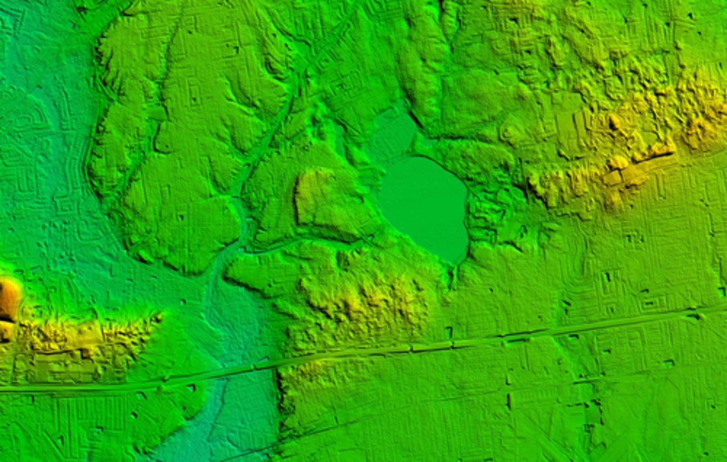
Glacial erosion landforms
- Corrie.
- Arete.
- Pyramidal peak.
- Glacial trough.
- Hanging valley.
- Truncated spurs.
- Roche mounonnee.
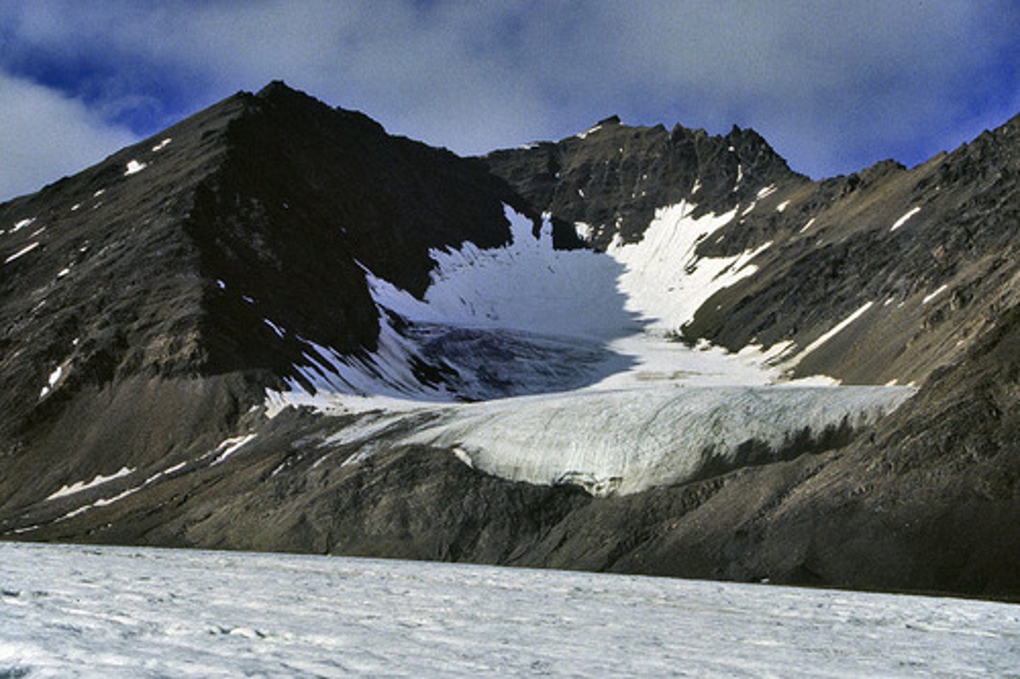
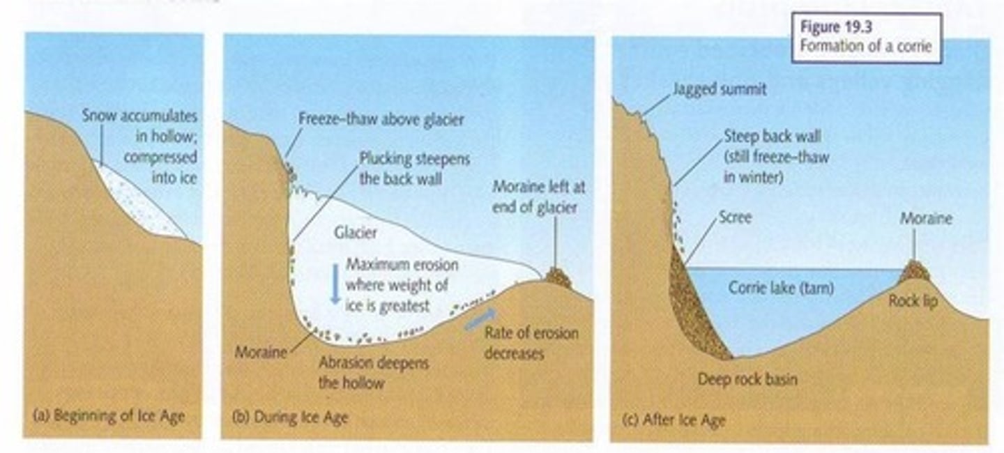
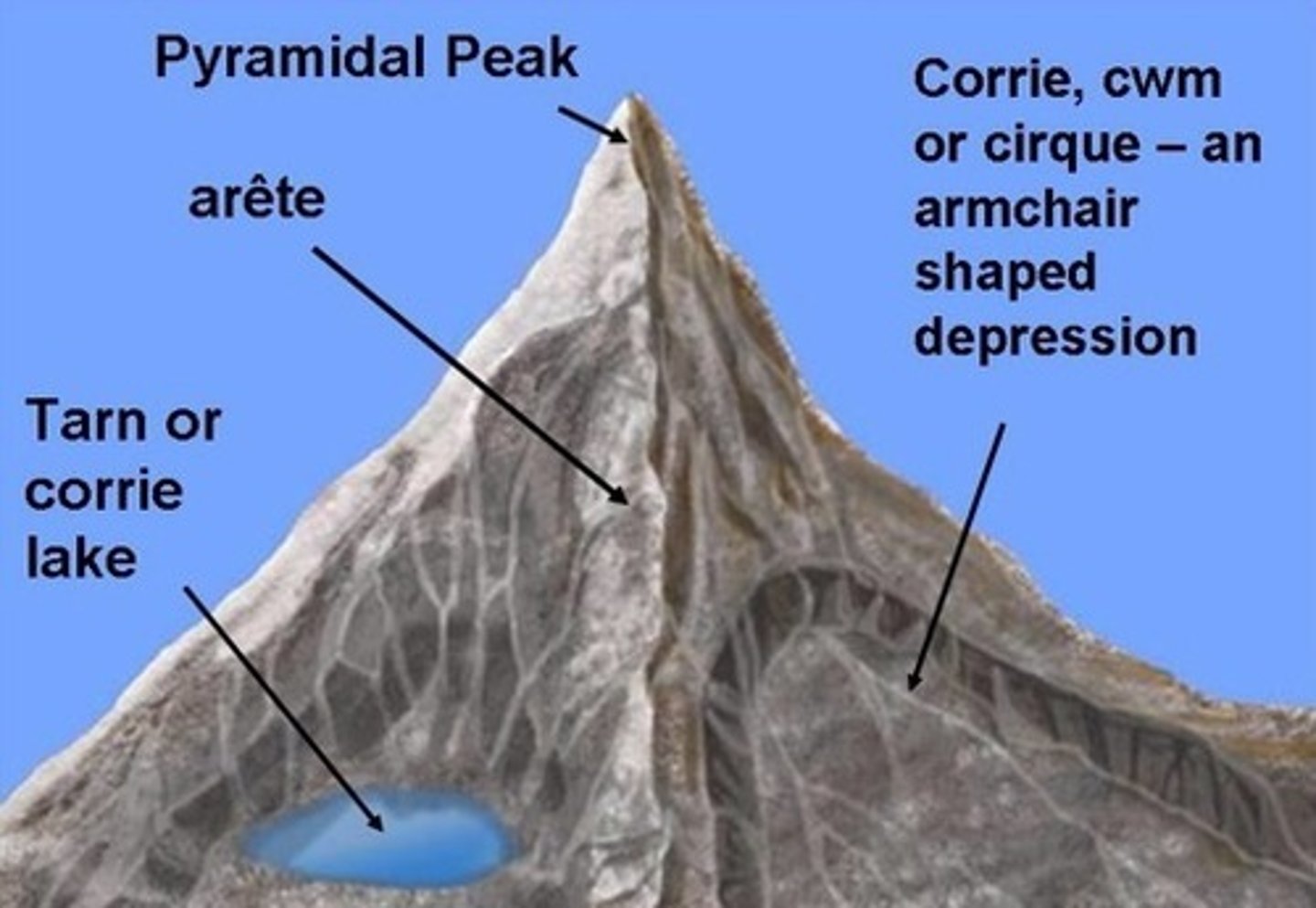
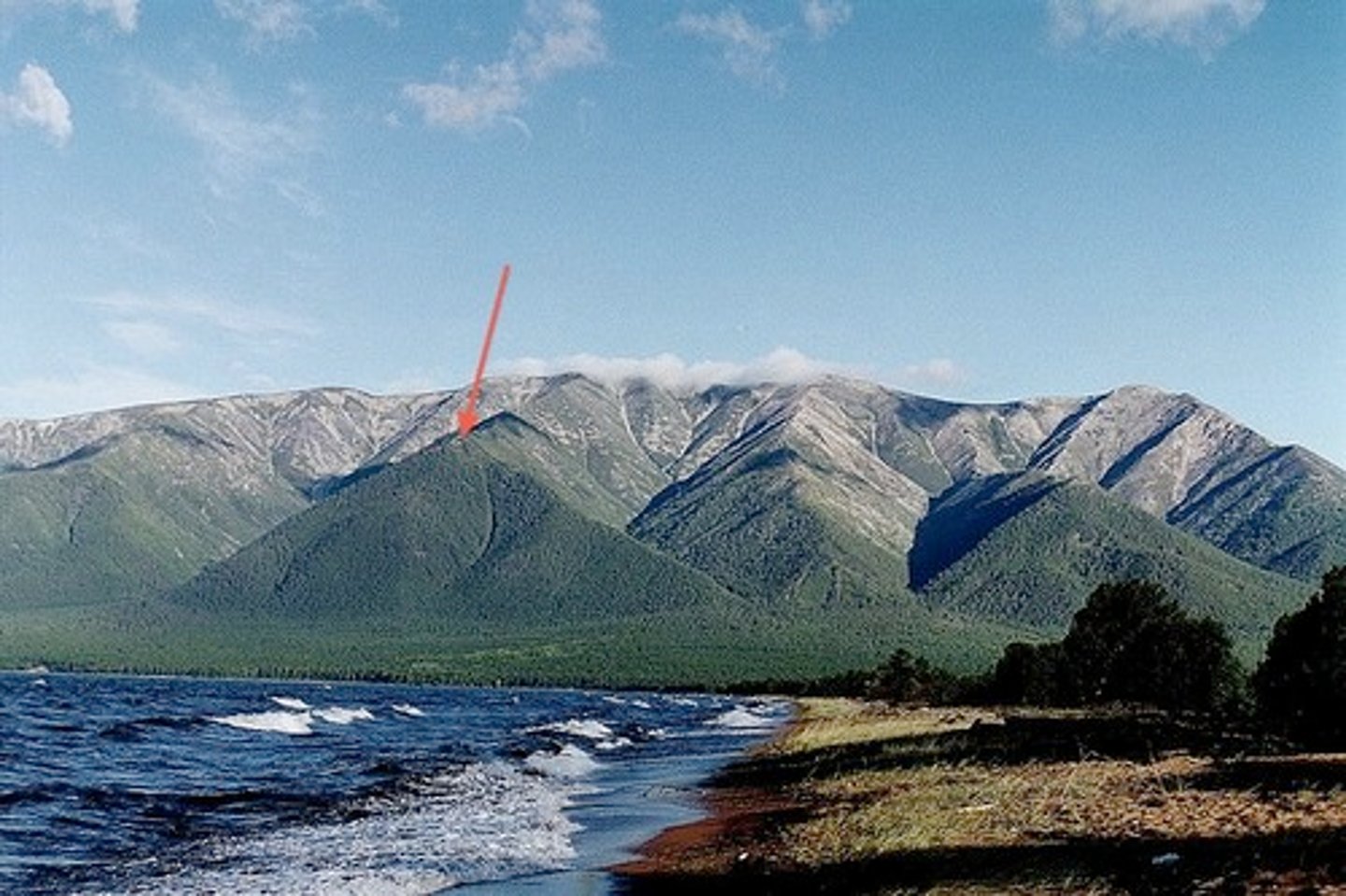
Corrie description
Armchair shaped hollow on side of a mountain, steep back wall, rock lip at front, tarns (lakes) form inside. Form on north/east facing slopes in UK, as these receive less insolation so most accumulation and least ablation.
Corrie formation
Snow collects in a hollow, nivation deepens it. As hollow enlarges snow becomes thicker and compressed into firn then ice. Frost shattering on back wall steepens it and provides debris. Basel sliding with abrasion and plucking deepen hollow. Ice flows over lip and downhill as glacier.
Arete description
Steep-sided ridge.
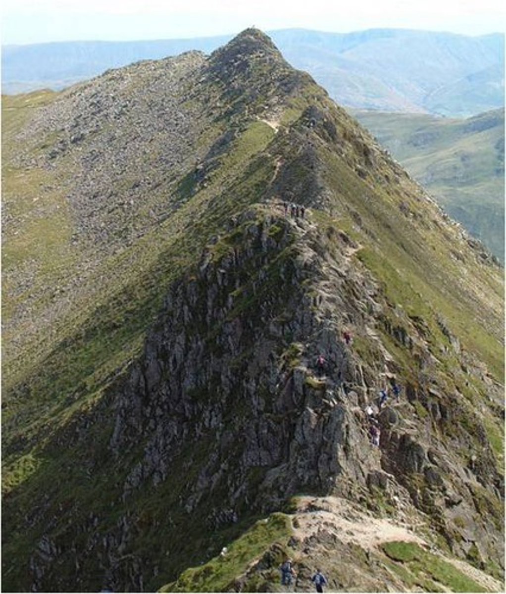
Arete formation
Form where two corries erode backwards into one another, sharpening the mountain ridge between them.
Pyramidal peak description
A pointed mountain peak with at least three sides.
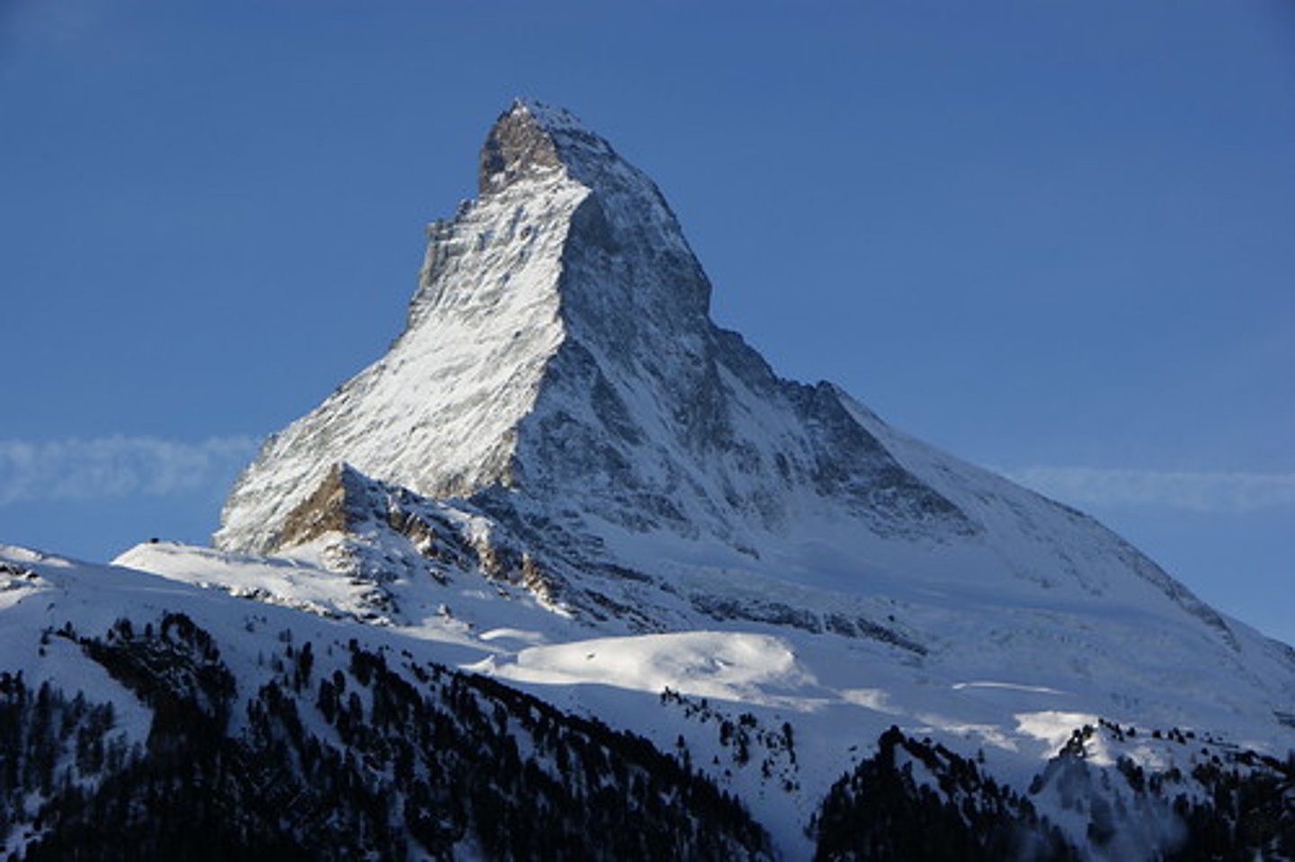
Pyramidal peak formation
Forms where three or more corries form back to back, their backwalls make the mountain peak.
Glacial trough description
Also known as U-shaped valleys. Steep sided valleys with flat bottom. Mis-fit streams run through the valley. Hanging valleys and truncated spurs are associated with them.
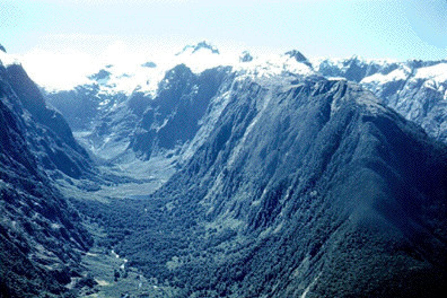
Glacial trough formation
Develop where glaciers flow into pre-existing river valleys, widening and deepening them. Glaciers straighten the valley and cut off spurs, forming truncated spurs.
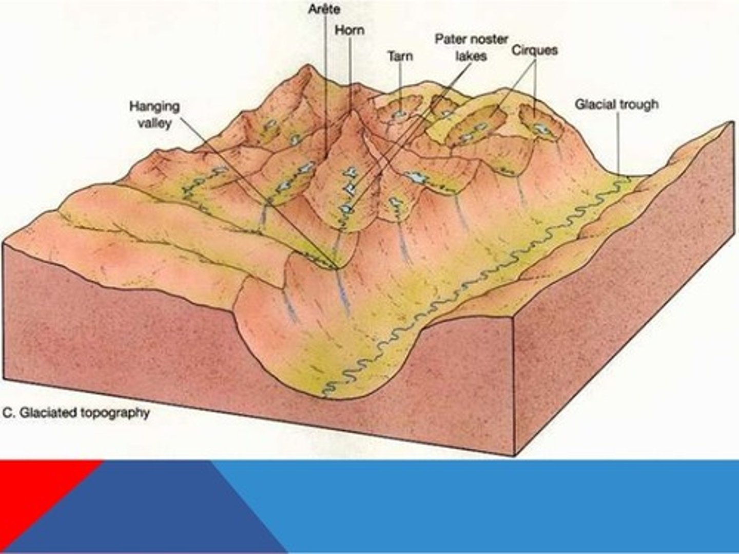
Hanging valley formation
Forms where ice in tributaries cannot erode effectively because its movement is blocked by ice in main valley or they are smaller than main glacier. Valley floor is eroded less deeply so valley remains higher and smaller than main glacial trough.
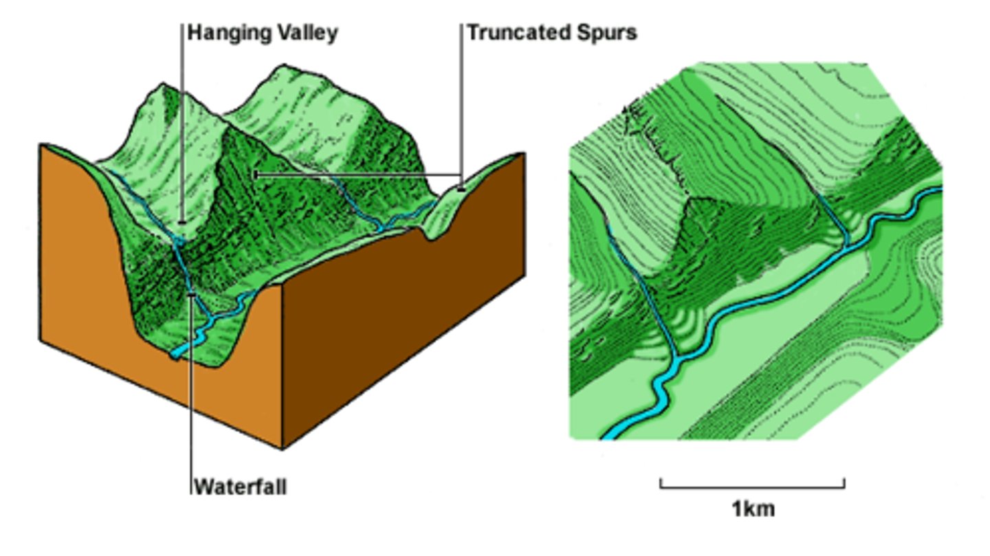
Truncated spurs formation
Formed when ridges of land that stick out into main valley (spurs) are chopped off (truncated) as main glacier moves past.
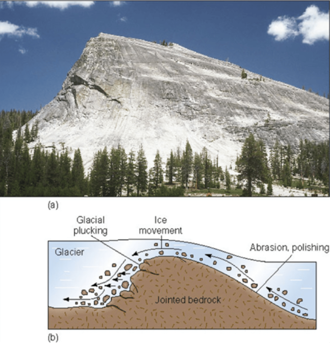
Roche mountonnee description
Asymmetrical resistant mass of rock on valley floor. Upstream (stoss) side is smooth. Downstream (lee) side is steep and rough. Around 1-10m in height and 3-30m in length
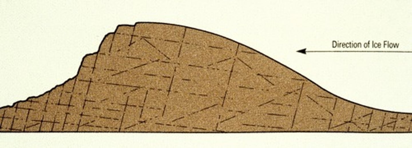
Roche mountonnee formation
Ice flows over the valley, eroding less resistant rock. Stoss side becomes smoothed by abrasion as glacier goes over it, lee side becomes rough and steep where plucking occurs.
Glacial deposition landforms
- Moraines.
- Drumlins.
- Erratics.
- Till plains.
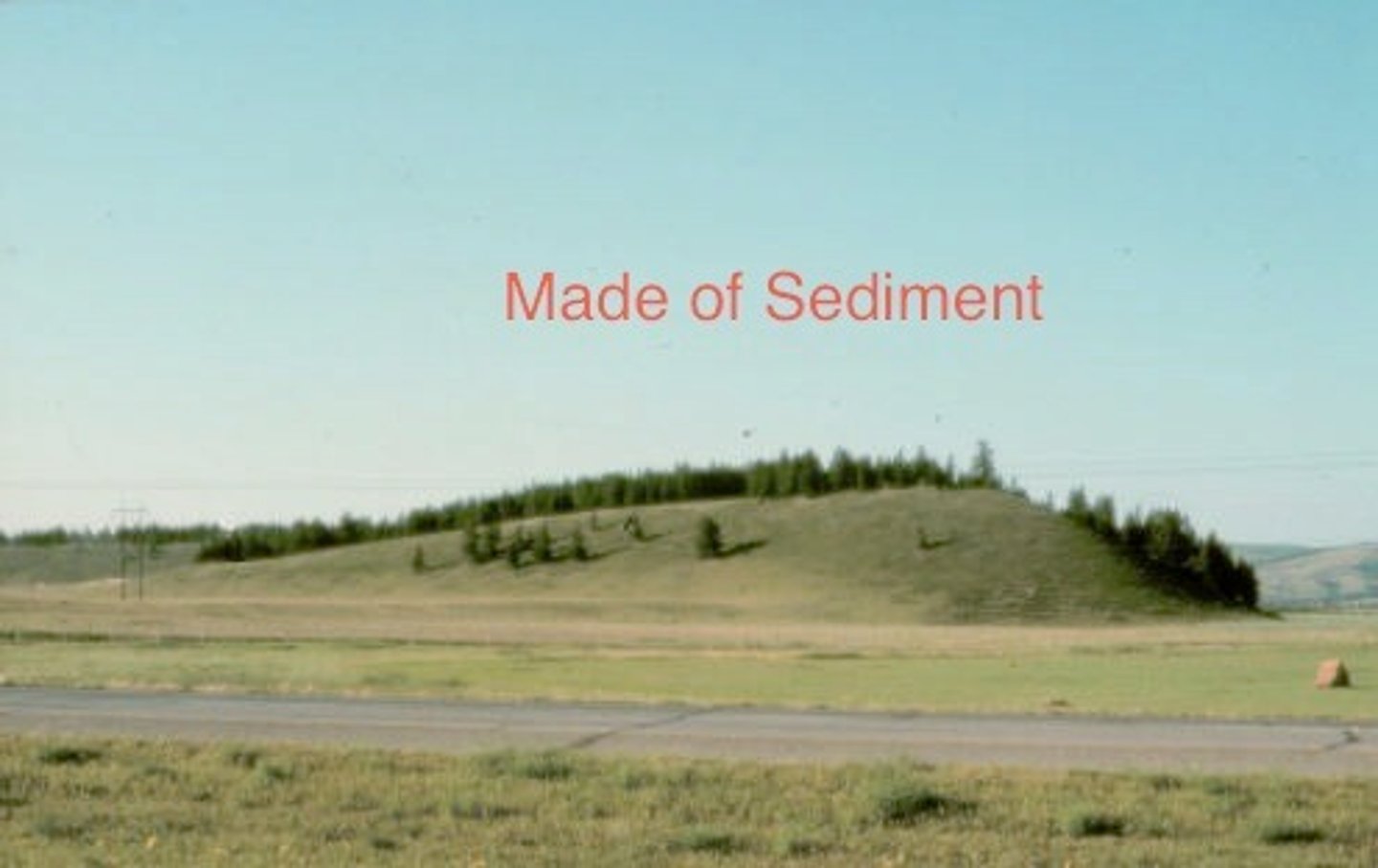
Moraine description
Ridges of deposited till. Unsorted. There are 6 types: lateral, terminal, medial, ground, recessional, push.
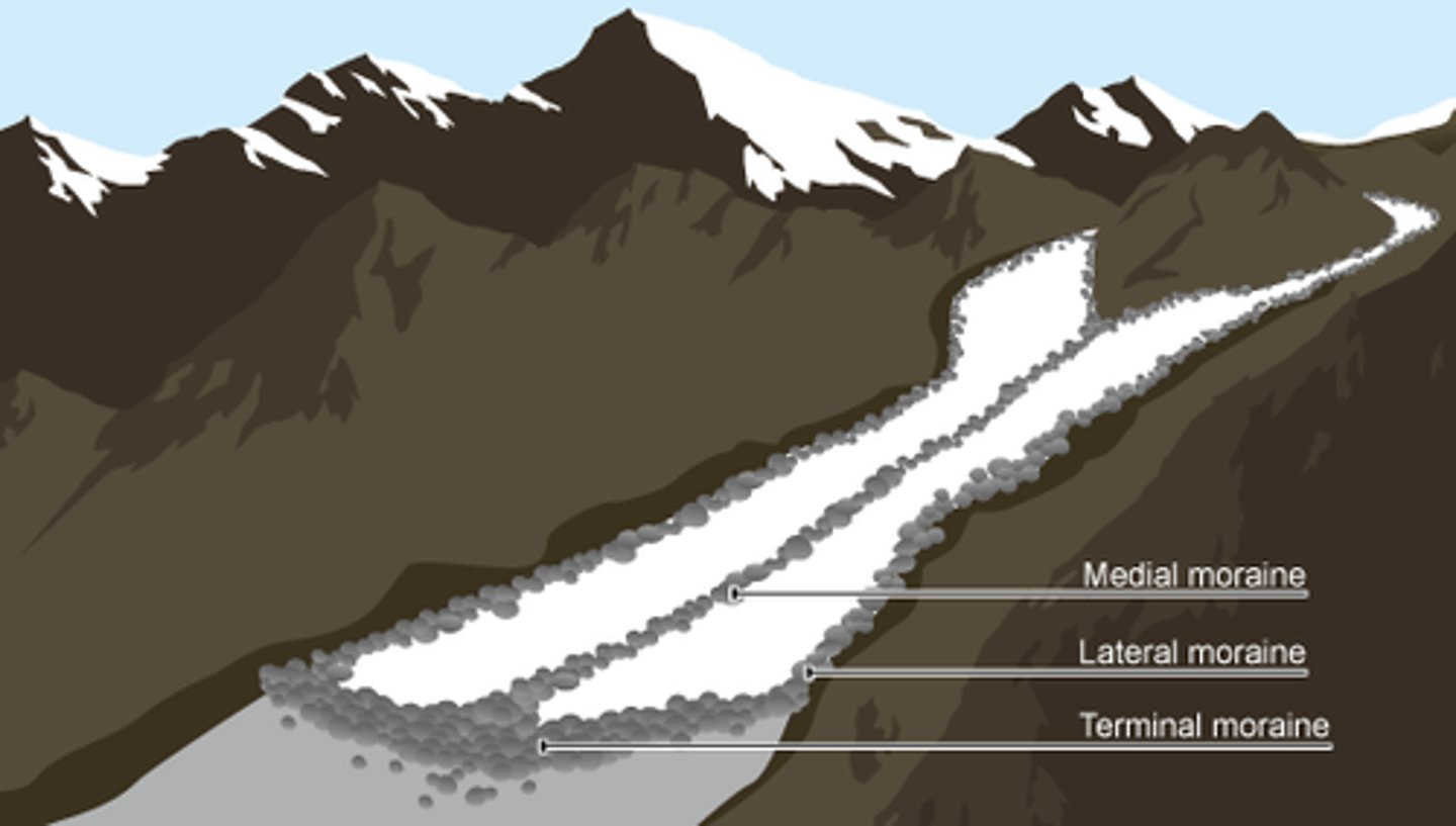
Lateral moraine
Moraine produced at the side of a glacial having rolled there after falling on top of the ice of from frost shattering of valley sides.
Terminal moraine
Marks the furthest point of a glacier, found where snout ended and deposited debris as semi-circular hillocks of till.
Medial moraine
Found at the confluence of two glaciers where two lateral moraines merged to form a deposit down the middle of the main glacier.
Ground moraine
Form as the ice margin rapidly retreats, not pausing long enough to form end moraines but still depositing till and other sediments. Consists of an irregular blanket of till deposited under a glacier.
Recessional moraine
Formed where ice has retreated further up the valley from terminal moraine and left a new pile of unsorted debris.
Push moraine
Formed where ice has readvanced down the valley and pushed materials ahead of it.
Moraine formation
Glaciers transport material (debris) as they move. When the glacier melts this material is left behind and a moraine is formed. The material is unsorted and unstratified.
3 ways glaciers can transport material
- Supraglacial.
- Englacial.
- Subglacial.
Supraglacial debris
Debris carried on the surface of a glacier that originates from rock falls, snow and rock avalanches.
Englacial debris
Debris dispersed in the interior of a glacier, originates as surface debris that is buried in accumulation, fallen into crevasses or as basal debris that is raised from the bed by thrusting or folding.
Subglacial debris
Debris which has been released from ice at the base of a glacier. Originates from plucking.
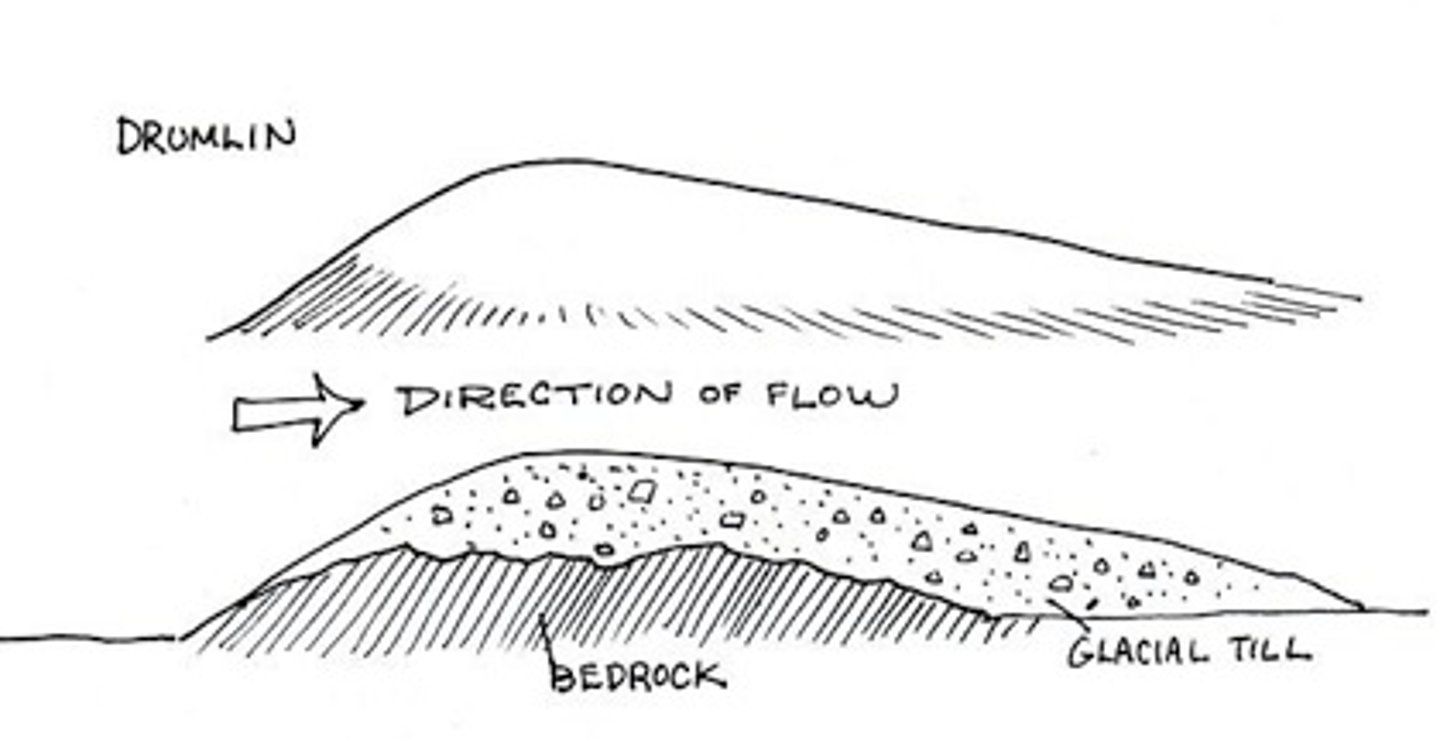
Drumlin description
An oval-shaped hill composed of glacial till of pre-existing sediments. Can be up to 50m in height and 1000m in length. A group of drumlins is called a swarm or a basket of eggs. Stoss (upstream) side is wide and tall, lee (downstream) side is narrow and low.
Drumlin formation
No one is 100% sure. May be that till got stuck around a rock to little hill sticking out into the glacier. May be that original mound of dropped till got streamlined when ice readvanced over it.
Erratic description
Rocks that have been picked up by a glacier, carried along and deposited in an area of different geology than its source.
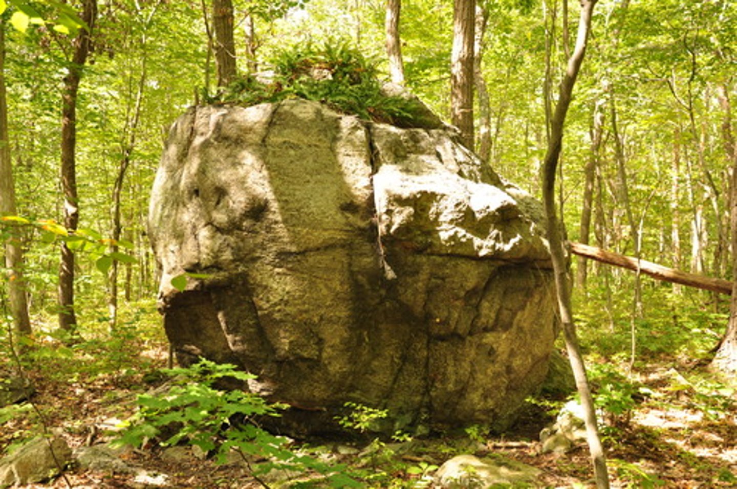
Erratic formation
Part of the valley is broken off as the glacier moves over it in the process of plucking. The rock is transported in the glacier. When the glacier retreats the rock is deposited.
Till plain description
A large expanse of gently rolling hills of till. Till is mixed/unstratified materials directly posited by ice. When deposited irregularly it forms moraines.
Till plain formation
An ice sheet becomes detached from the main body of a glacier. When it melts, the debris being transported in ice is deposited where it is, forming a large plain of unsorted till.
Fluvioglacial landforms
- Meltwater channels.
- Kames.
- Kame terraces.
- Eskers.
- Outwash plains.
Meltwater channel descriptions
Wide, deep channels in the landscape where a glacier was. Can have shallow streams running through them.