Geography - Tectonic hazards case studies
1/10
There's no tags or description
Looks like no tags are added yet.
Name | Mastery | Learn | Test | Matching | Spaced | Call with Kai |
|---|
No analytics yet
Send a link to your students to track their progress
11 Terms
Earthquakes
California - San Andres fault conservative plate boundary
Christchurch - New Zealand - liquefaction cause by 2010 earthquake. cars and houses sank, infrastructure was destroyed. Built on soft soil and sand.
China 1976 Tangshan - predication. Had where and when but no magnitude and had 200,000 deaths. or Loma Prieata in San Francisco, used seismic gap so had where and magnitude but did not know when, forecasted but didn’t predict.
Haiti earthquake - 7.0 magnitude, shallow focus, liquefaction, near the capital city, no preparation, corruption, no building control and lack of education. impacts were that already poor infrastructure was damaged, damage to airports and ports prevented aid,1/4 government were killed so they were low to respond, outbreak of cholera cause by poor sanitation. recovery - 5 years after they were still recovering foreign aid was not given to government because of corruption so TNCs were paid by charities to rebuild.
Tsunamis
2004 Indian Ocean Boxing Day tsunami - killed over 200,000 people, 3rd biggest earthquake measured, 9.1 on Richter scale, waves reached 10m, hit 14 countries.
2011 Tohuku earthquake Japan - killed 20,000 people, 4th biggest earthquake, 11 on mercalli scale, had a warning system so death toll wasn’t as high, had 20 minutes of warning before, $360 billion of damage, highest cost of any earthquake, had tsunami walls. DART system. Good preparedness, well developed disaster plans, education and emergency drills, fast response.
Volcanoes
1986, a large cloud of co2 was emitted and killed 1700 people.
Kilauea Hawaii - large eruption in 2018 was caused by an earthquake where the epicentre was the volcano. Lava covered 13.7 square miles of land over two months and destroyed 700 homes which meant over 200 people were displaced.
Amero tragedy - bad management, lahars killed 23,000 people and 3000 more are missing. took about an hour for Lamar to get there, a risk map was made before showing the danger but there was no evacuation. 1985.
Iceland volcano - Eyejafjallajockull was a mega disaster as it created a large ash cloud which grounded many flights and had a large economic impact.
Risk equation
R = HxV/C
Risk = hazard (especially magnitude) x Vulnerability / capacity to cope (management)
Vulnerability - factors that make a country prone to disasters. E.g. Building codes, quality of infrastructure, preparedness plans, level of corruption, access to education, high population density.
PAR mo
pressure and release model
root causes - debt, corruption, poverty, foreign aid
Dynamic pressures - lack of urban planning, preparedness, education, disaster management , rapid urbanisation, high population denisty, deforestation (landslides)
unsafe conditions - liquefaction, illegal housing on hillsides, low GDP, poor infrastructure, water and sewage.
Multiple hazard zones
A place that gets tectonic hazards and hydro-meteorological hazards exposed to two or more hazards. Philippines, California, Caribbean.
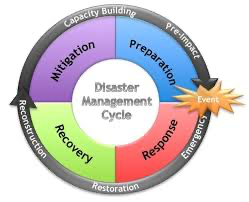
Hazard management cycle

mitigation - taking steps to reduce impact and loss of life and property.
Preparedness - minimising loss of life and property by facilitating response and recovery plans. e.g. warning systems, stockpiling, equipment and supplies and creating evacuation routes.
Response - coping with the disaster, main aim is saving lives and protect property e.g. restoring critical infrastructure.
recovery - short term recovery, focuses on people’s immediate needs so it overlaps with the response phase.
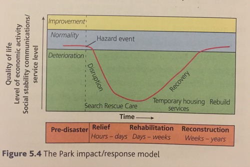
The Park Model

Hazard management - mitigation strategies
mitigation - avoid, delay or prevent hazard
land use zoning - local government regulate how land in an area is used. High risk areas are divided into zones based n likely type and level of damage
diverting lava flows - methods like building barriers and channels have been mostly ineffective because the path is hard to predict and terrain has to be suitable. has only worked once in Iceland on Heimaey Island, sprayed lava with water to protect harbour.
GIS mapping - can be used to identify where evacuation routes should be placed or help with rescue and recovery. This information can help local to identify areas most affected and then find nearest location where aircraft can land.
hazard resistant design and engineering defences - buildings can be built to resist shaking in earthquakes, roofs can be sloped to reduce ash build up from volcanoes. buildings can be anchored and elevated for tsunamis. existing buildings can be modified, called retrofitting.
Hazard management - adaptation strategies
Adaptation - change what people do to lessen impact
high tech monitoring - technology plays an important role in helping communities and individuals to become less vulnerable. monitoring systems allow scientists to learn more and predict hopefully more accurately.
crisis mapping - after Haiti earthquake in 2010 members created a live interactive Mao that people provided information via social media. These locations were put on the map and placed online. Rescue and aid workers began to use constantly updated maps. uses crowd sourced information to accurately map areas struck by disasters.
modelling hazard impact - computer models allow scientists to predict the impacts of hazard events on communities. Information is fed into computers which then models the effects of a disaster. can compare the effects on different scenarios. maps can then be used to develop plans and strategies to reduce impact.
public education - good education and public awareness helps to reduce vulnerability and prevent hazards from becoming disasters.
Modify, role of NGOs, Aid donors, insurance and communities in managing loss
modify the loss - aid, insurance
modify vulnerability - prediction, community awareness, education
modify the event - land use zoning, retrofit buildings, tsunami walls
modify the cause - spray lava, prevention, small hazards; stopped landslides
role of aid donors - emergency aid, short term aid, longer term aid
role of NGOs - can provide funds, search and rescue and help develop reconstruction plans if government is struggling.
role of insurance - coverage helps communities recover as it provides them with money to repair home but few people have protection for tectonic hazards, not available in developing countries.
role of communities - local people are first to respond an in remote or isolated communities it can take weeks for aid to arrive so locals have to set up shelters and clear debris.