Intro Msci Final Study Guide
0.0(0)
Card Sorting
1/184
There's no tags or description
Looks like no tags are added yet.
Last updated 2:31 AM on 5/10/23
Name | Mastery | Learn | Test | Matching | Spaced | Call with Kai |
|---|
No analytics yet
Send a link to your students to track their progress
185 Terms
1
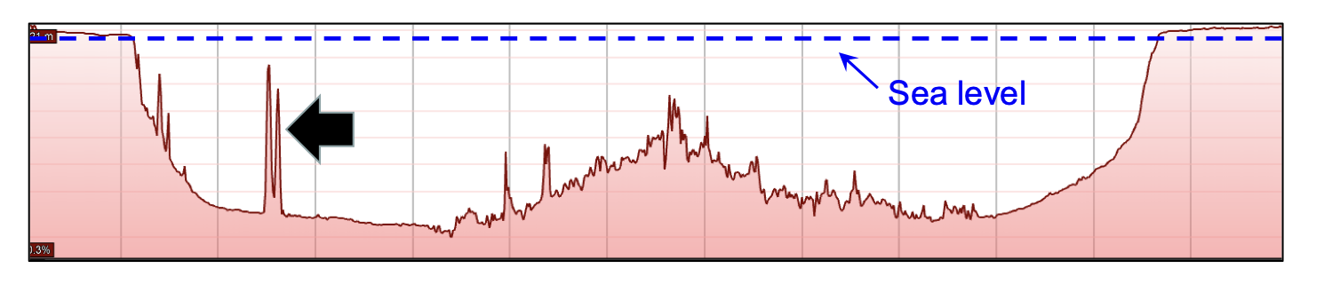
New cards
How/Why did early civilization use the oceans?
Food, Trade, Transportation
2
New cards
Why were the oceans explored in the Middle Ages/Age of Exploration?
Glory/God (colonization), Gold (trade)
3
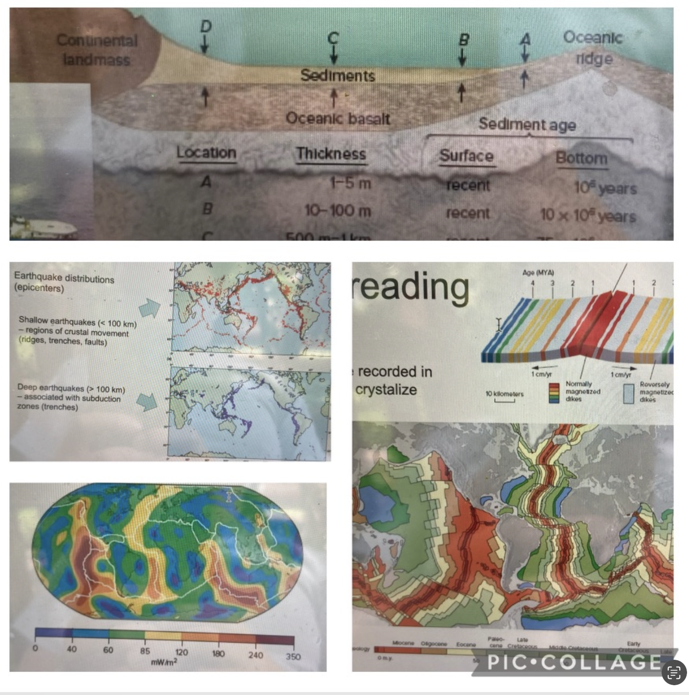
New cards
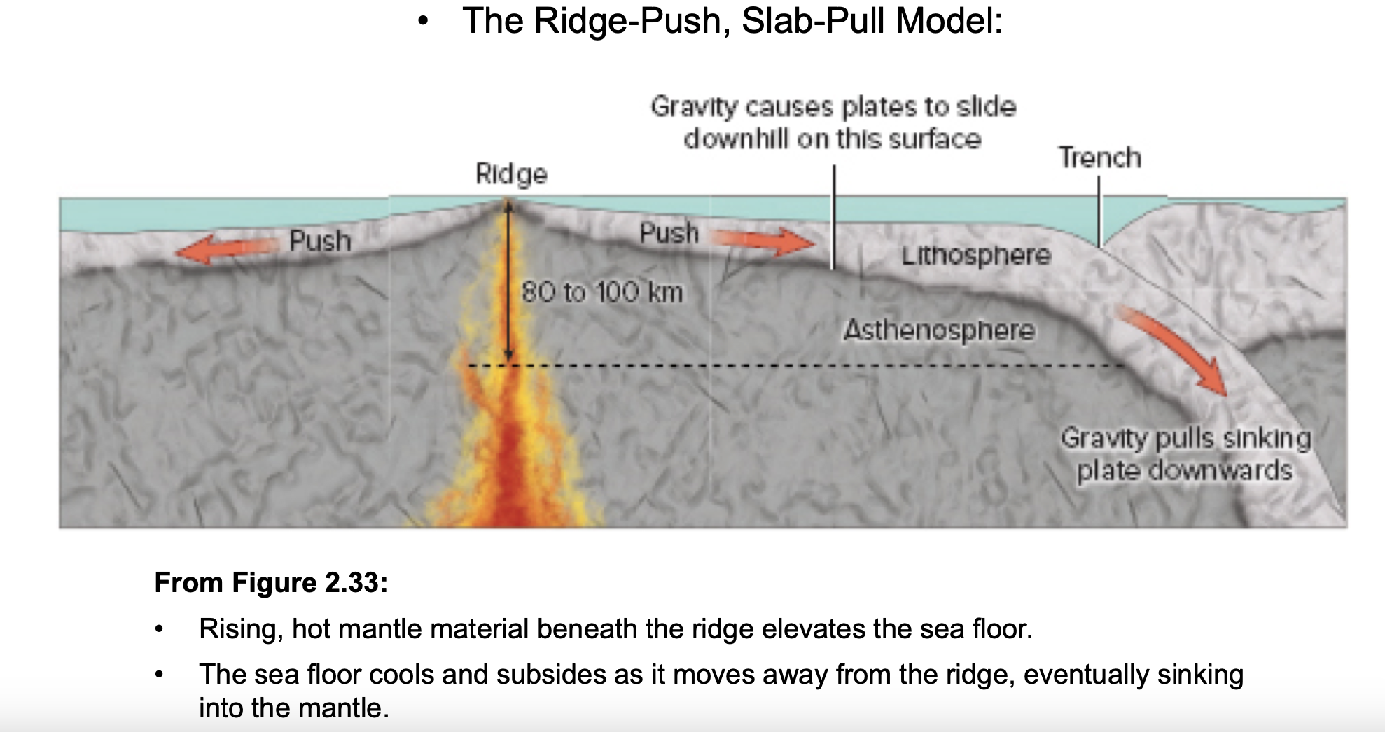
What was the focus of oceanography in the 19th/20th centuries?
Charting/Mapping, Bathymetry, Wind Patterns
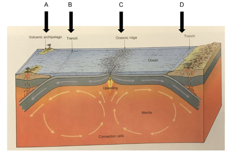
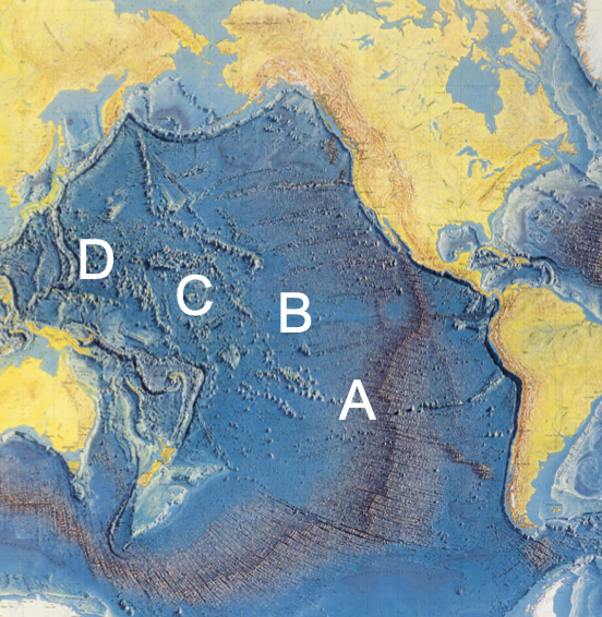
4
New cards
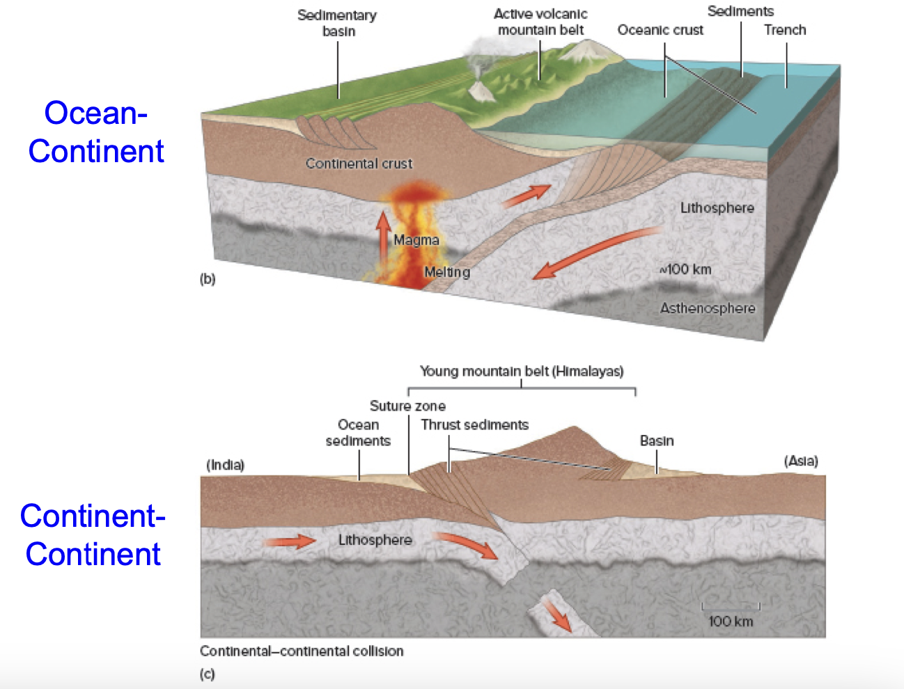
First Major Oceanographic Cruise
Challenger Expedition
5
New cards
What political event sparked a surge in marine science?
World War II
6
New cards
What’s the focus of modern oceanography?
Scientific Discovery
7
New cards
Approximate age of the Earth
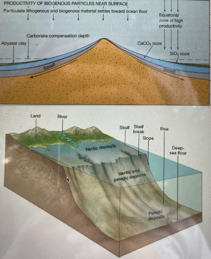
4\.5 billion years, based on radiometric dating
8
New cards
Water is hypothesized to have come from…
precipitates of volcanic activity, asteroids, and/or water already present on Earth’s core
9
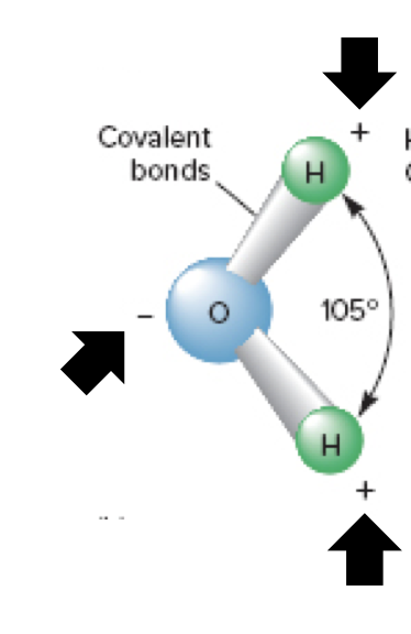
New cards
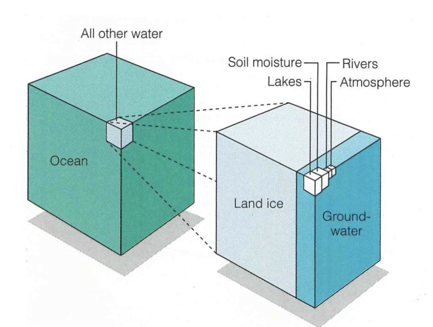
Earth’s water reservoirs, largest-smallest
oceans, ice caps/glaciers, groundwater, rivers/lakes, atmosphere
10
New cards
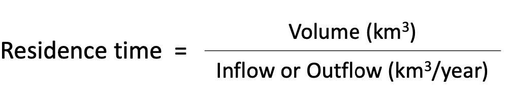
What is the residence time of a body of water with a volume of 1,000,000 km^3 and an inflow of 25,000 km^3/year
40 years
11
New cards
Approximate residence time of earth’s oceans
3,000 years
12
New cards
Which hemisphere contains most of the world’s oceans
Southern
13
New cards
Average depth of the oceans
3,800 mWhat
14
New cards
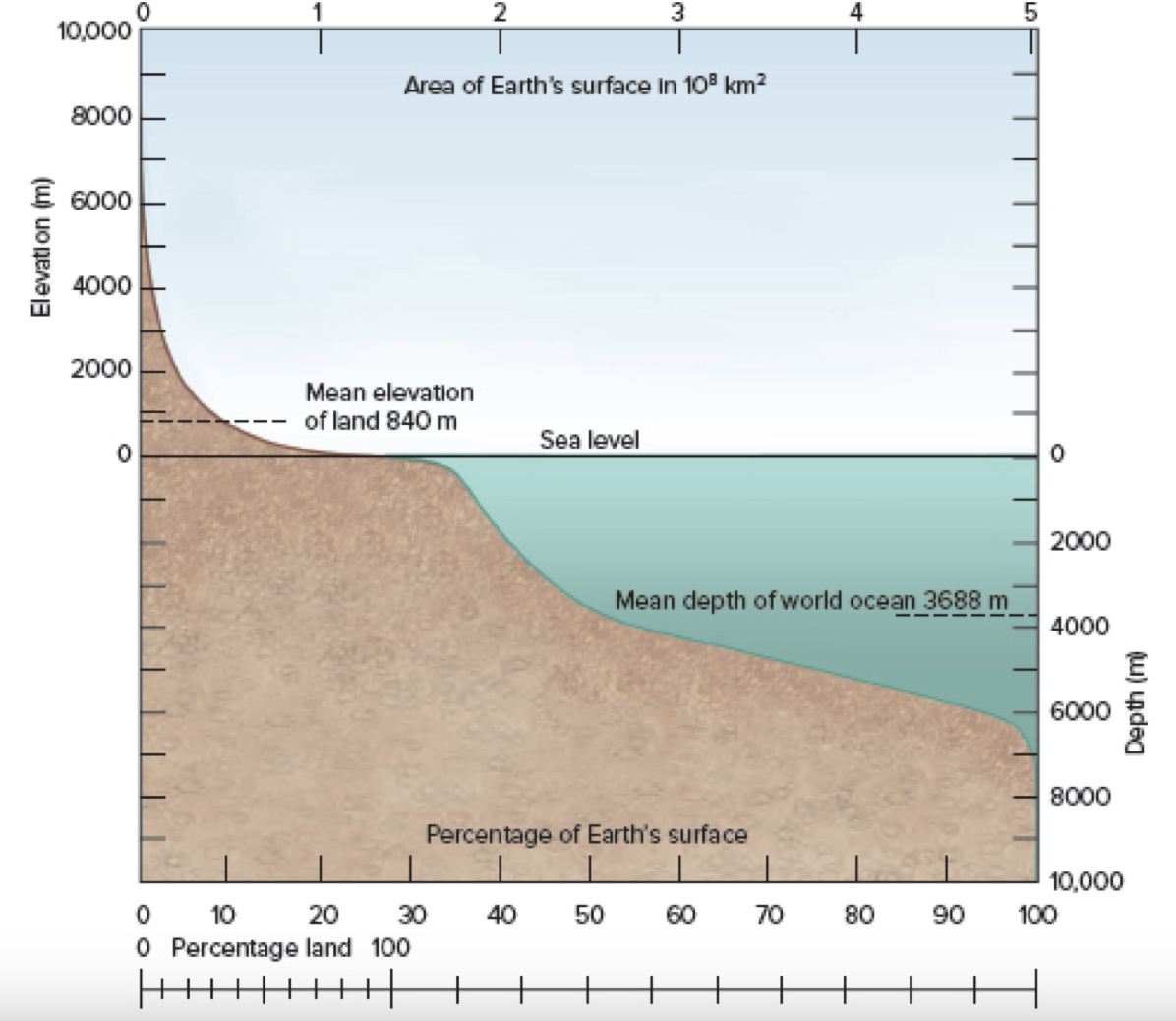
What percent of ocean area is shallower than 5,000 m?
65%
15
New cards
_____ increases as you move toward the center of the Earth
pressure, density, temperature
16
New cards
What is the sequence of Earth’s layers based on physical characteristics?
lithosphere, asthenosphere, mesosphere, outer core, inner core
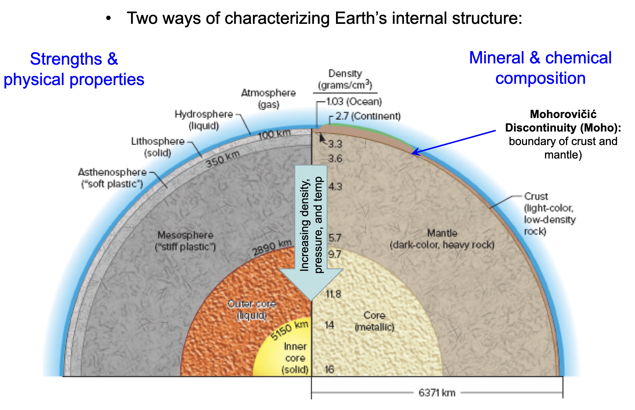
17
New cards
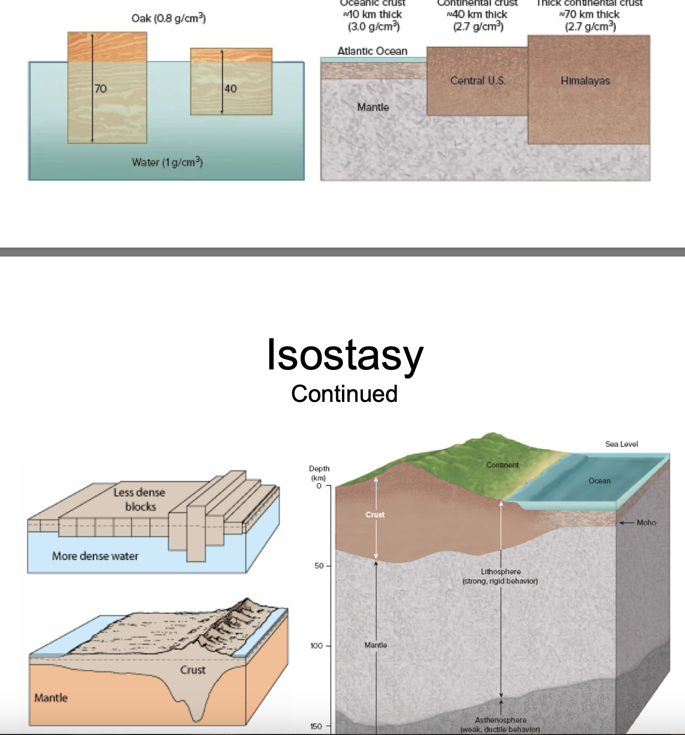
The ___ *layer of Earth is relatively ductile, meaning the layers above it can “float” on top of it via* __ equilibrium
Asthenosphere, Isostacy
18
New cards
How does oceanic crust differ from continental crust?
Oceanic crust is younger, thinner, and more dense
19
New cards
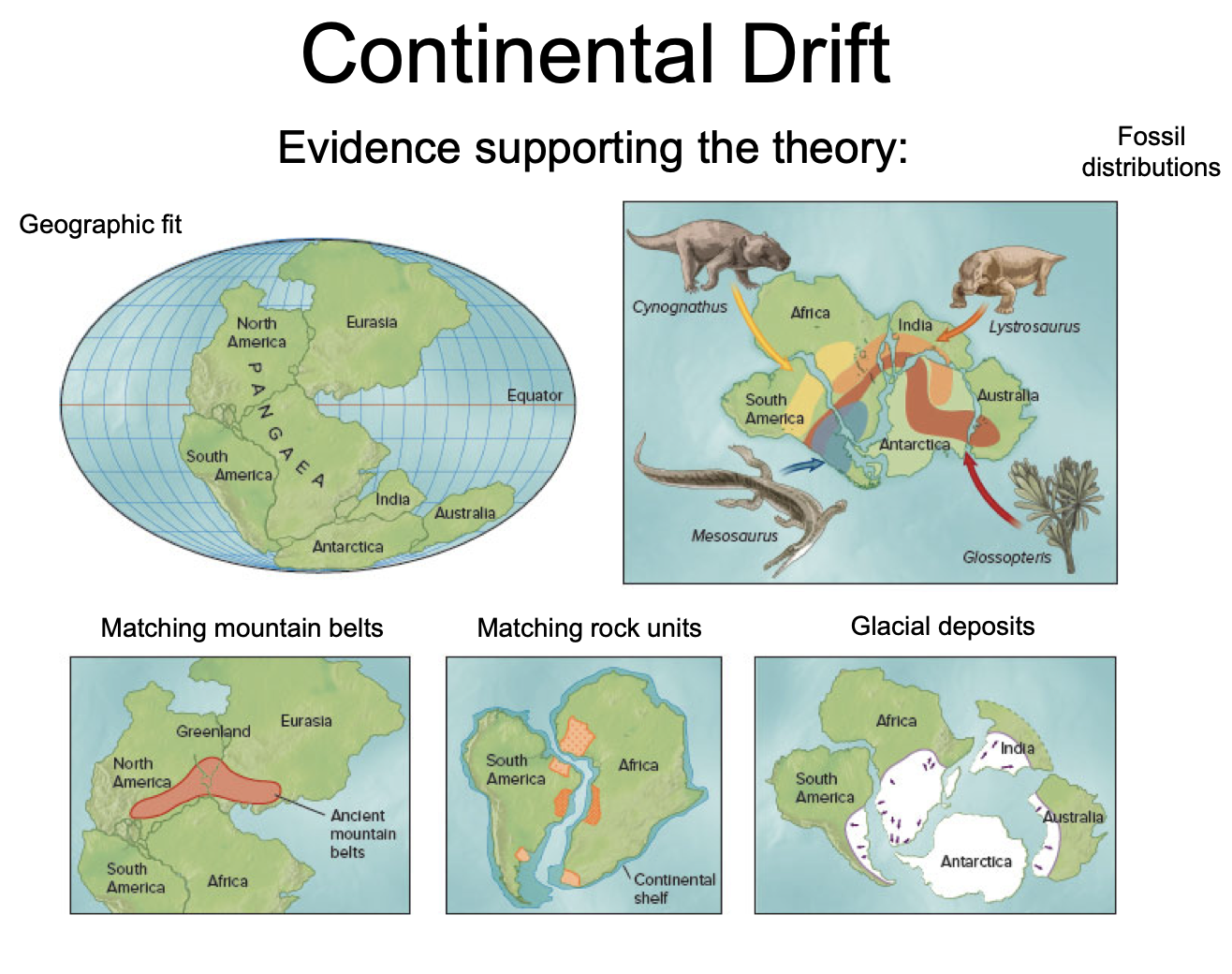
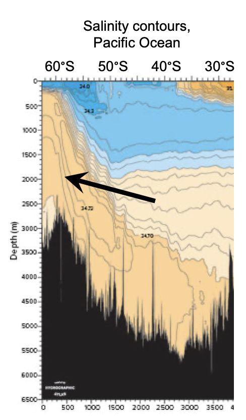
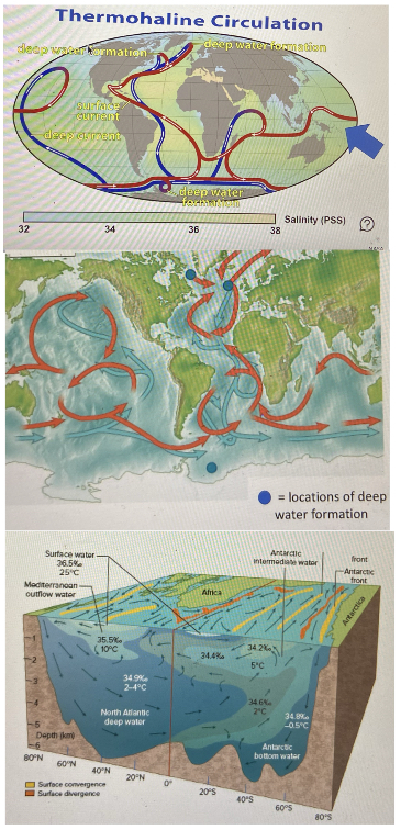
What evidence was there for continental drift?
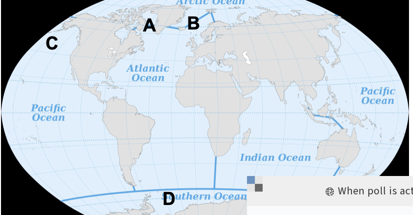
“Puzzle-Piece” fit of continents, their rocks/mountain ranges/glacial deposits, and their fossil records
20
New cards
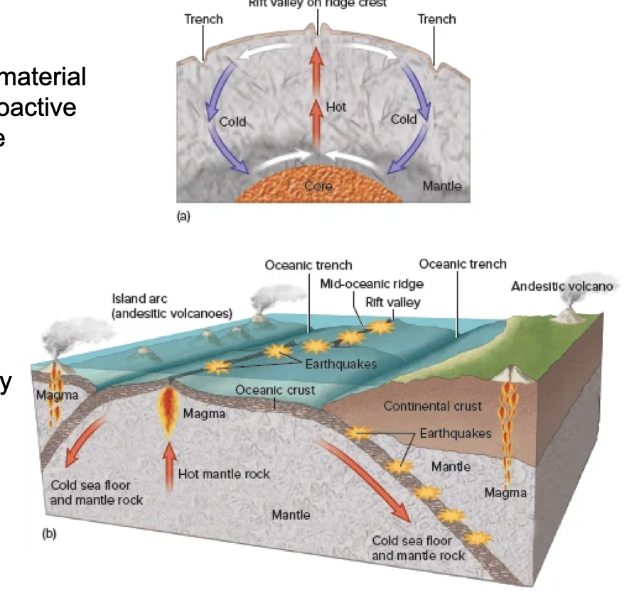
What process drives sea-floor spreading, and how?
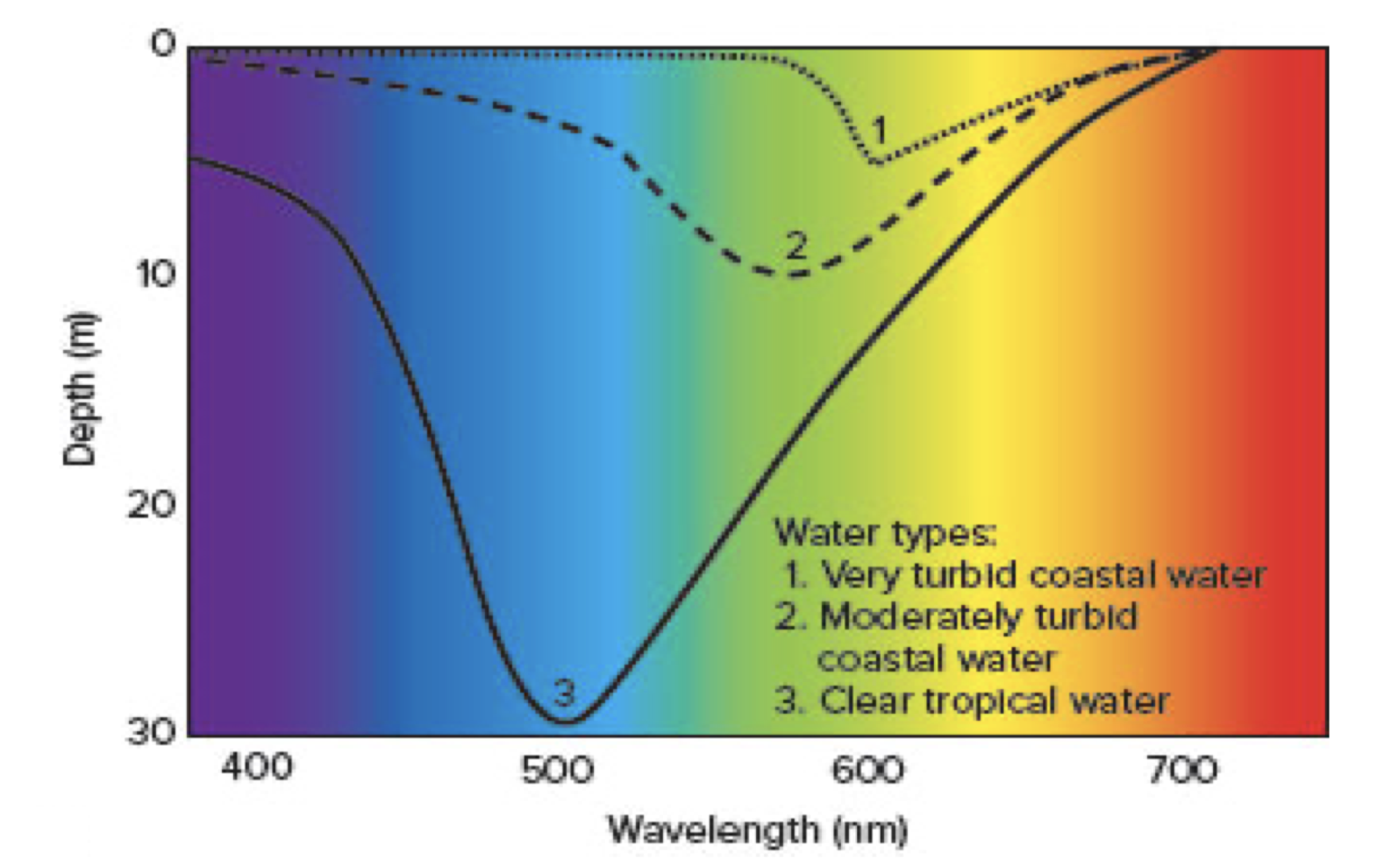
Convection currents in Earth’s mantle, bringing up new crust at mid-ocean ridges, and subducting/melting older crust in deep sea trenches
21
New cards
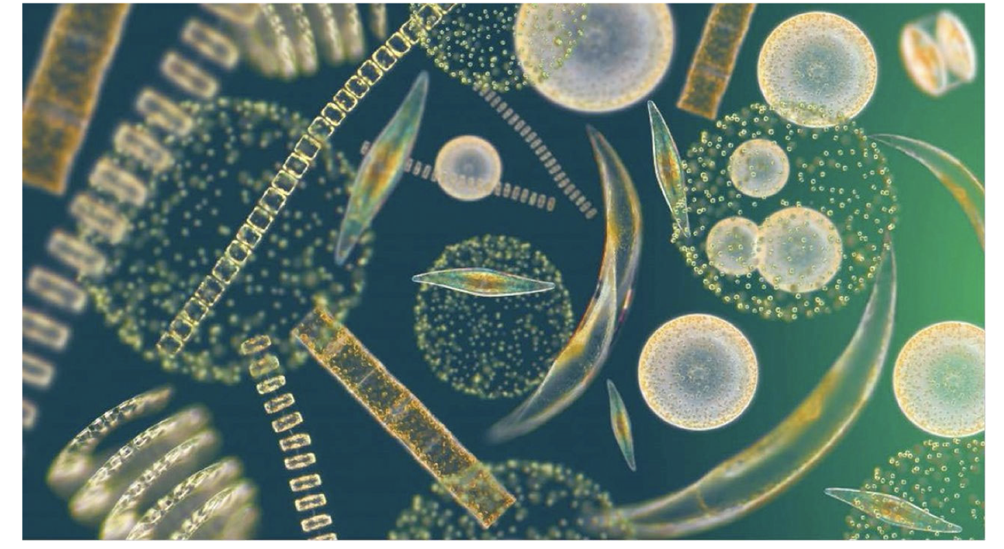
What evidence was there for sea-floor spreading?
Earthquake/heat distributions, carbon dating/thickness/ magnetic “fossil” bands of rocks,
22
New cards
Which model best describes the mechanisms behind plate tectonics?
Ridge-Push, Slab-Pull
23
New cards
What is the typical rate for sea-floor spreading?
cm/year
24
New cards

Which of these denotes a spreading center/divergent plate boundary?
C-the ocean ridge (and rift valleys)
25
New cards
Which of these denotes a convergent plate boundary?
B and D-the trenches
26
New cards
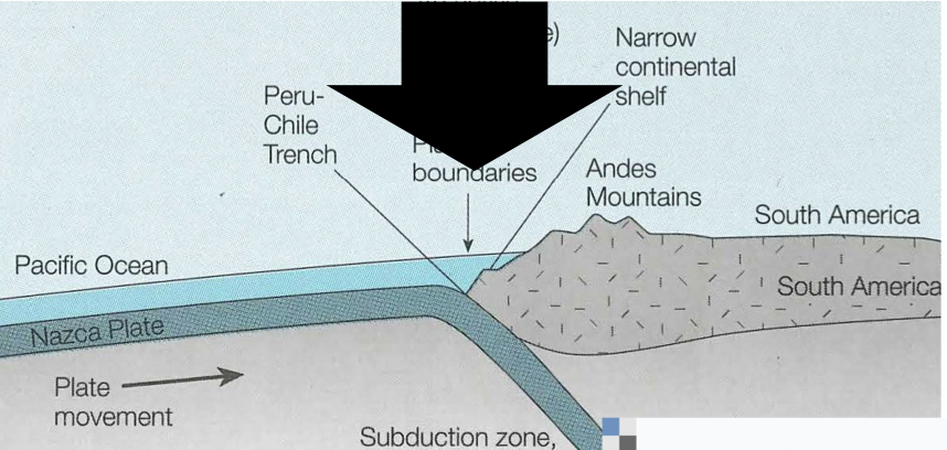
Which features characterize ocean-continent and continent-continent convergent boundaries?
Mountain ranges (ex. Volcanic Andes Mountains along Peru Trench, Himalayas along Asia/India boundary)
27
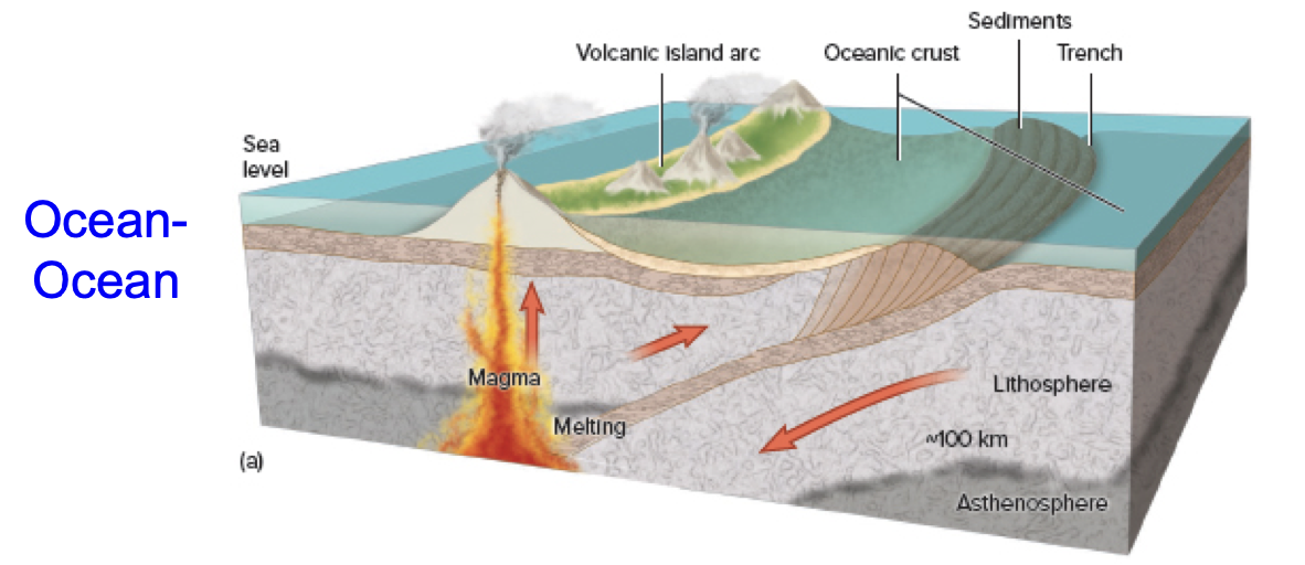
New cards
What features characterize an ocean-ocean convergent boundary?
Volcanic Island Arc (ex. Aleutian Islands)
28
New cards
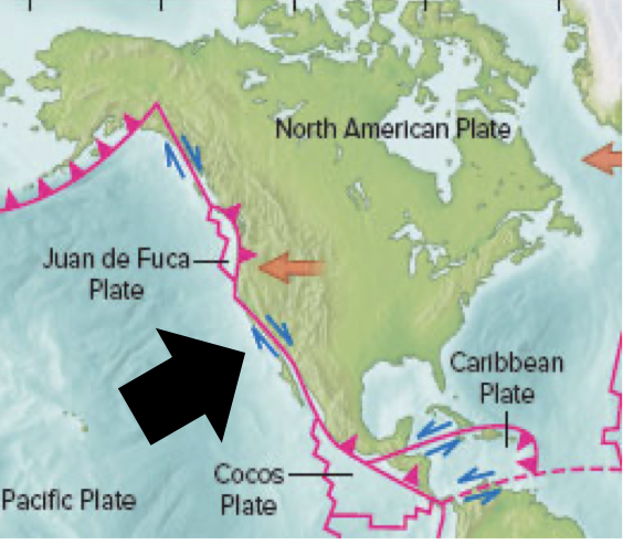
What kind of plate boundary is marked?
Transform Boundary-San Andreas Fault (North American and Pacific Plates sliding past one another)
29
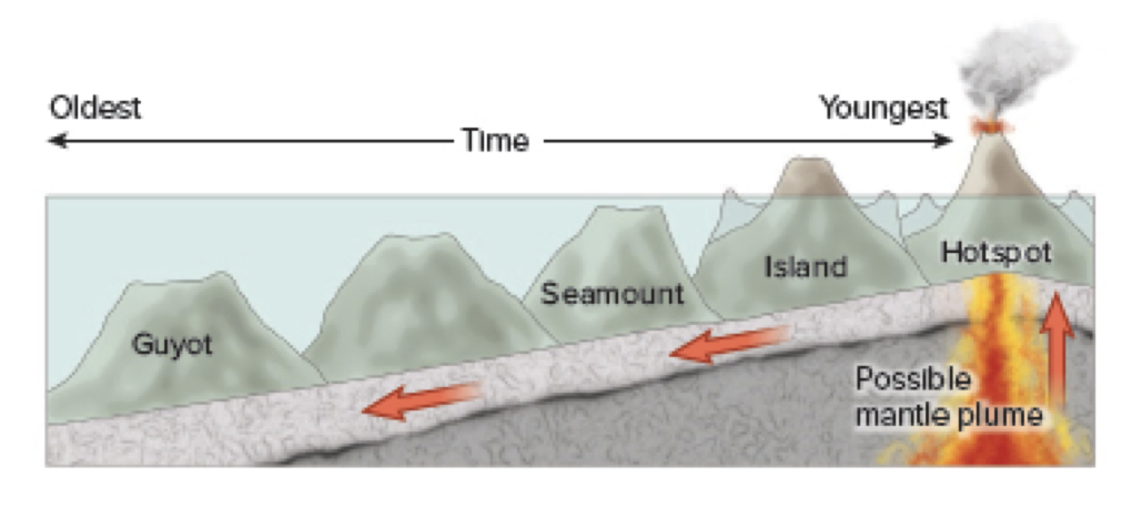
New cards
What forms over hot spots?
Volcanic Island/ Seamount Chains (ex. Hawaiian Islands over Pacific Hotspot)
30
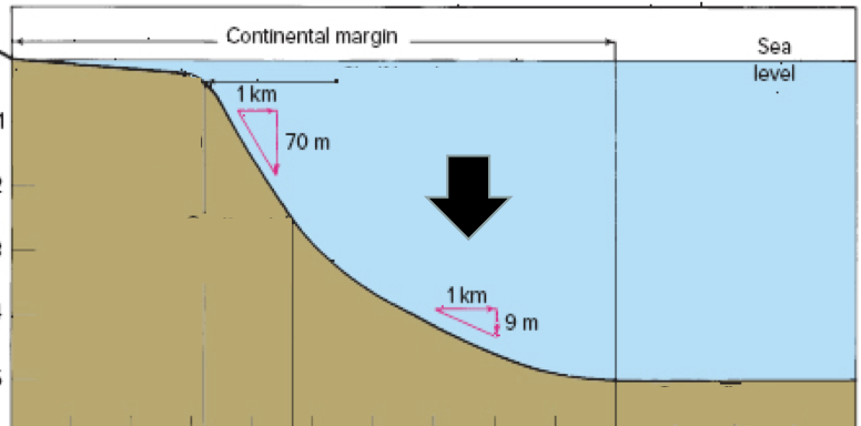
New cards
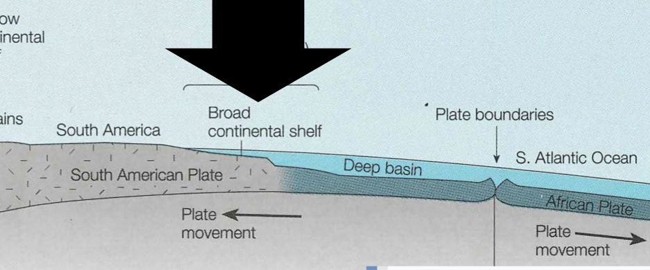
What kind of continental margin is pictured?
Passive
31
New cards
What kind of continental margin is pictured?
Active
32
New cards
Where would you expect to find a wider continental shelf?
Along a passive margin
33
New cards

Where would you expect the strongest earthquakes and volcanism?
D-the active margin/subduction zone
34
New cards
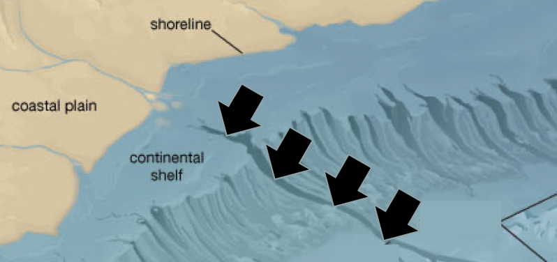
What is this feature?
Submarine canyons formed by turbidity currents along continental shelf
35
New cards
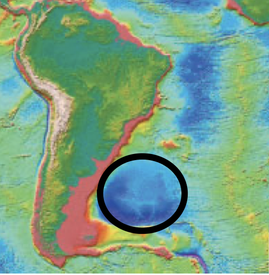
What is this seafloor province?
Continental rise
36
New cards
What is this seafloor province?
Abyssal Plain
37
New cards

What is this feature?
Atoll over a sinking seamount/guyot
38
New cards
What is this seafloor province?
Seamount
39
New cards
Where would you find the oldest and thickest sediments, and why?
D-continental margins, older crust far from the mid ocean ridge - the heavier, more abundant neritic (land) deposits immediately sink there and accumulate without being dissolved
40
New cards
As sediment grain size decreases…
…sinking rate decreases
41
New cards
Which sediment type is formed from chemical precipitation of sediments in sea water?
Hydrogenous (ex. manganese nodules, hydrothermal vents)
42
New cards
The depth at which calcareous ooze begins to dissolve is called…
…the lysocline
43
New cards
The depth at which ALL calcareous ooze is dissolved is called…
…the carbonate compensation depth. Deposition =/< absorption
44
New cards
Which sediments accumulate in the deepest regions of the abyssal plains?
Silicious
45
New cards
The uneven charges in this molecule indicate…
…polar hydrogen bonds
46
New cards
The specific heat of water is…
…comparatively high, allowing it to prevent extreme changes in global temperatures
47
New cards
The latest heat of water is…
…comparatively high-it takes large amounts of energy to change the chemical state of water, so it will absorb more heat and transport it around the globe to moderate climate
48
New cards
Why does ice float?
Hydrogen bonds expand past 4 degrees c and make the solid phase less dense than the liquid phase
49
New cards
As pressure, salinity, and depth increase, density of water…
…increases
50
New cards
What makes water such a good solvent?
Polar hydrogen bonds, which attract the polar bonds of NaCl and break it apart
51
New cards
Major constituents of seawater
Na^+, Cl^-, Ca^2+, K^+, SO4^2-
52
New cards
Average ocean salinity
35 \[ppt/psu\]
53
New cards
Salinity range of brackish water
0\.5-30 \[ppt/psu\]
54
New cards
variations in salinity are mainly caused by…
…regional variations in evaporation/precipitation
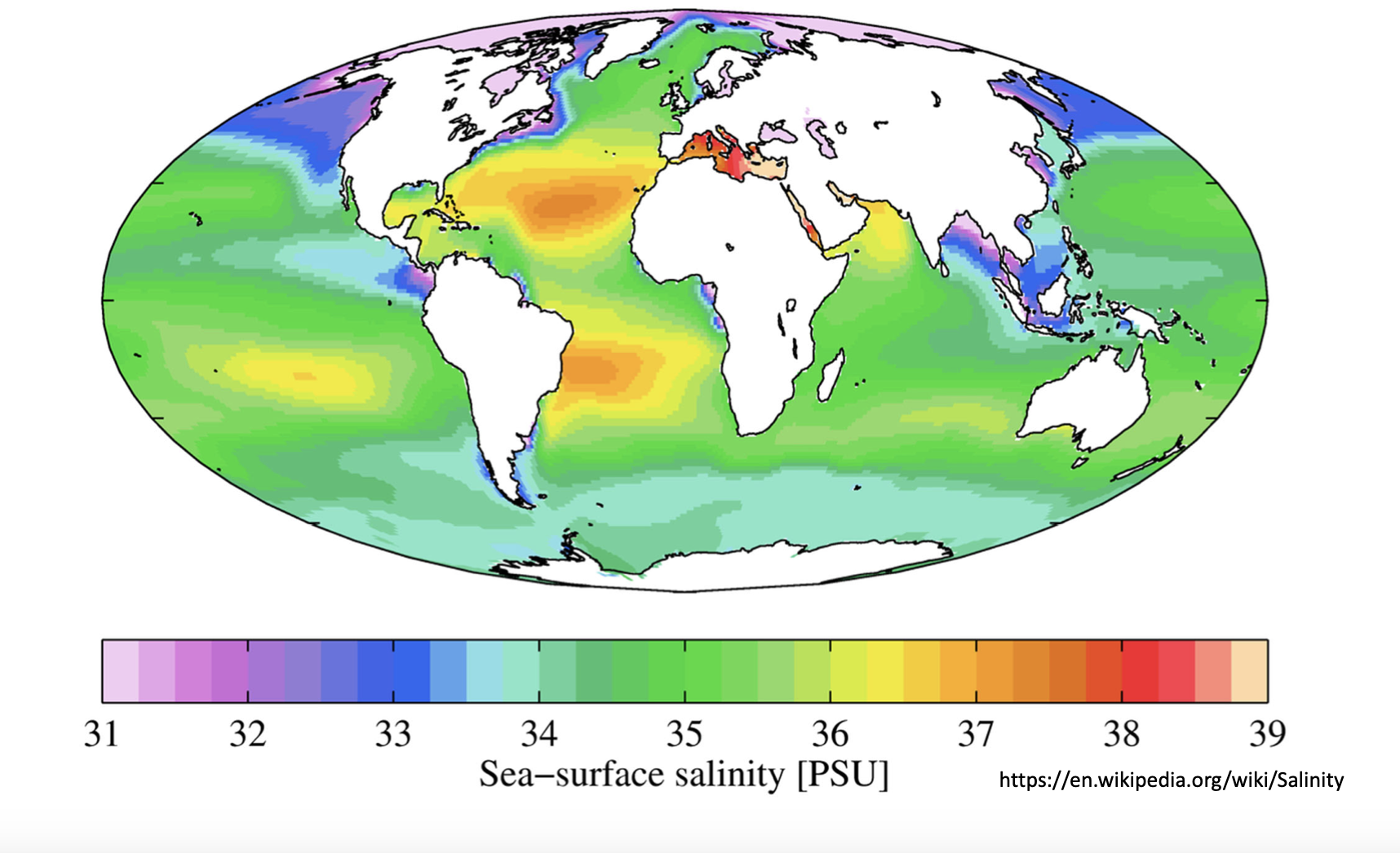
55
New cards
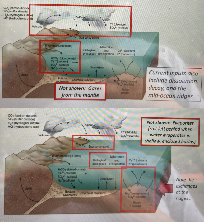
Salts in the ocean primarily cone from…
…volcanic gases/precipitates from earth’s mantle, and dissolution/decayof river sediment deposits and organic matter-constant input and output through these sources
56
New cards
Which of these best describes a hydrothermal vent?
Cool seawater enters fractures in the ocean’s crust near mid ocean ridges, is superheated, and propelled back into the ocean. Some elements from the Earth’s mantle are absorbed by seawater, while others precipitated out, through this process.
57
New cards
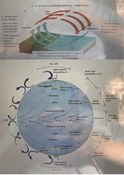
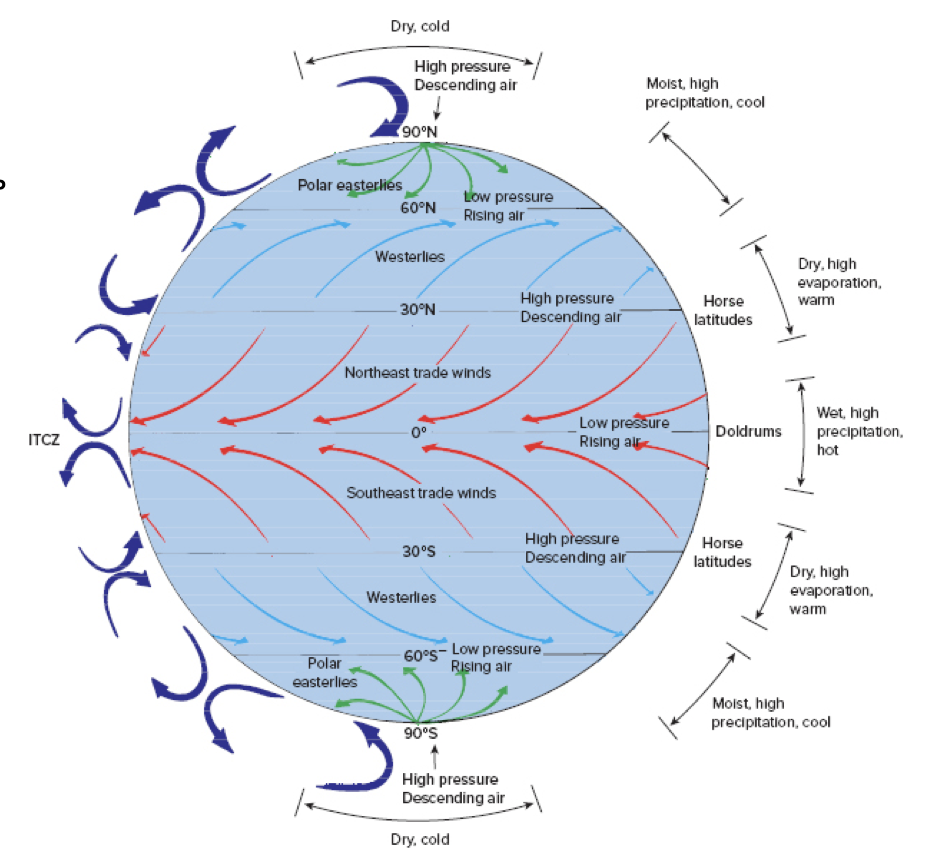
Atmospheric and ocean currents transport heat around the globe by…
…convection cells, characterized by elevated precipitation and warm (air/water) rising in one location, and dry climates and cold (air/water) sinking in another
58
New cards
Coriolis Effect
Moving fluids deflect to the right in the northern hemisphere and to the left in the southern hemisphere, due to earth’s rotation
59
New cards
Where does warm, moist air rise as part of the atmospheric convection cells?
Equator and 60 degrees latitude
60
New cards
Where does cool, dry air sink as part of atmospheric convection cells?
Poles and 30 degrees latitude

61
New cards
Where would you find the trade winds?
Between o and 30 degrees latitude

62
New cards
Where would you find the westerlies?
Between 30 and 60 degrees latitude
63
New cards
Where would you find the polar easterlies?
Between 60 and 90 degrees latitude

64
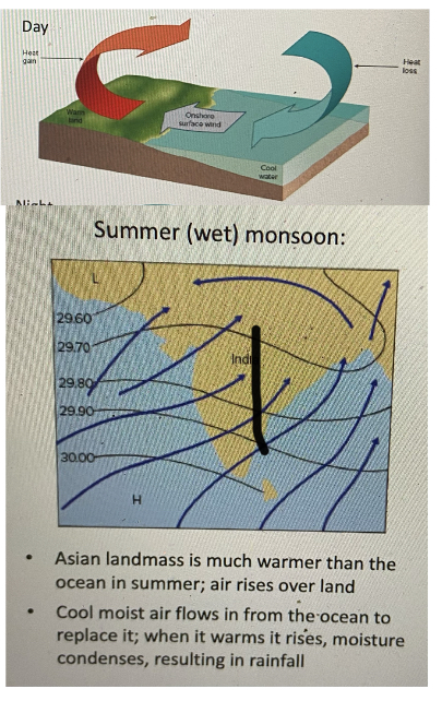
New cards
What direction are the winds moving during monsoon season?
From ocean to land
65
New cards
Cool sea breezes at the coast are due to…
…land heating faster than the ocean during the day

66
New cards
Hurricanes…
…are low-pressure systems that form over tropical waters and transport heat from equator-poles along the major atmospheric wind bands
67
New cards
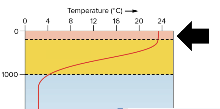
What is this layer of the surface ocean called?
Mixed Layer
68
New cards

The layer of rapidly changing temperature (in yellow) is called…
…the thermocline
69
New cards
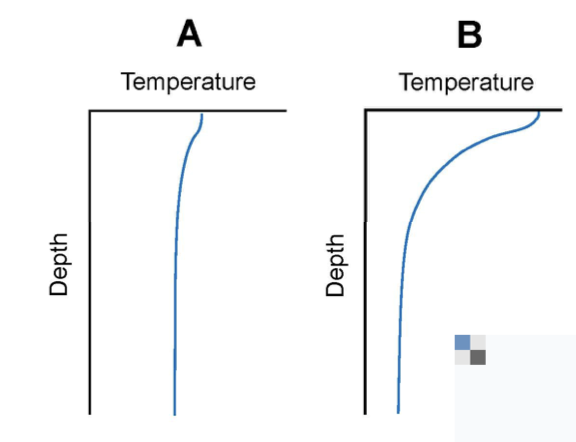
The difference between these two profiles is that…
…B is more strongly stratified than A and is typical of summer
70
New cards
What direction do surface ocean currents travel in the northern hemisphere?
45 degrees to the right of the wind
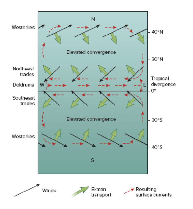
71
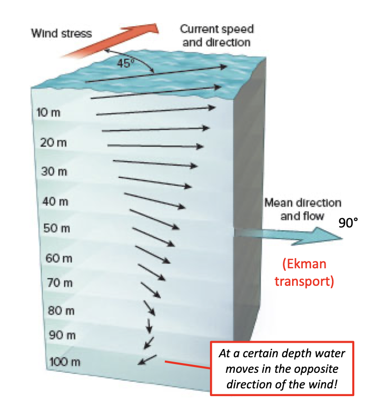
New cards
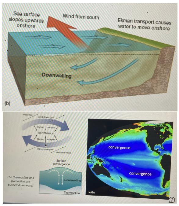
In the northern hemisphere, what is the direction of net Beckman transport?
90 degrees to the right of the wind
72
New cards
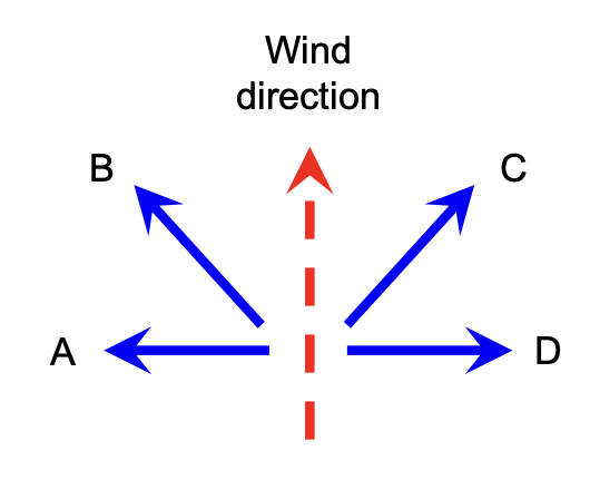
If you’re in the southern hemisphere and the dashed red line is the direction of the wind, which lines indicate the direction of surface currents and Beckman transport?
B is the direction of surface currents, A is the direction of net Eckman transport

73
New cards
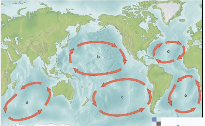
What two forces are balancing these large currents, what direction do they rotate, and what can the center be described as?
Geostrophic gyres-balanced by Coriolis effect and gravity, traveling clockwise in the northern hemisphere and counterclockwise in the southern hemisphere with a convergence zone “hill” in the center
74
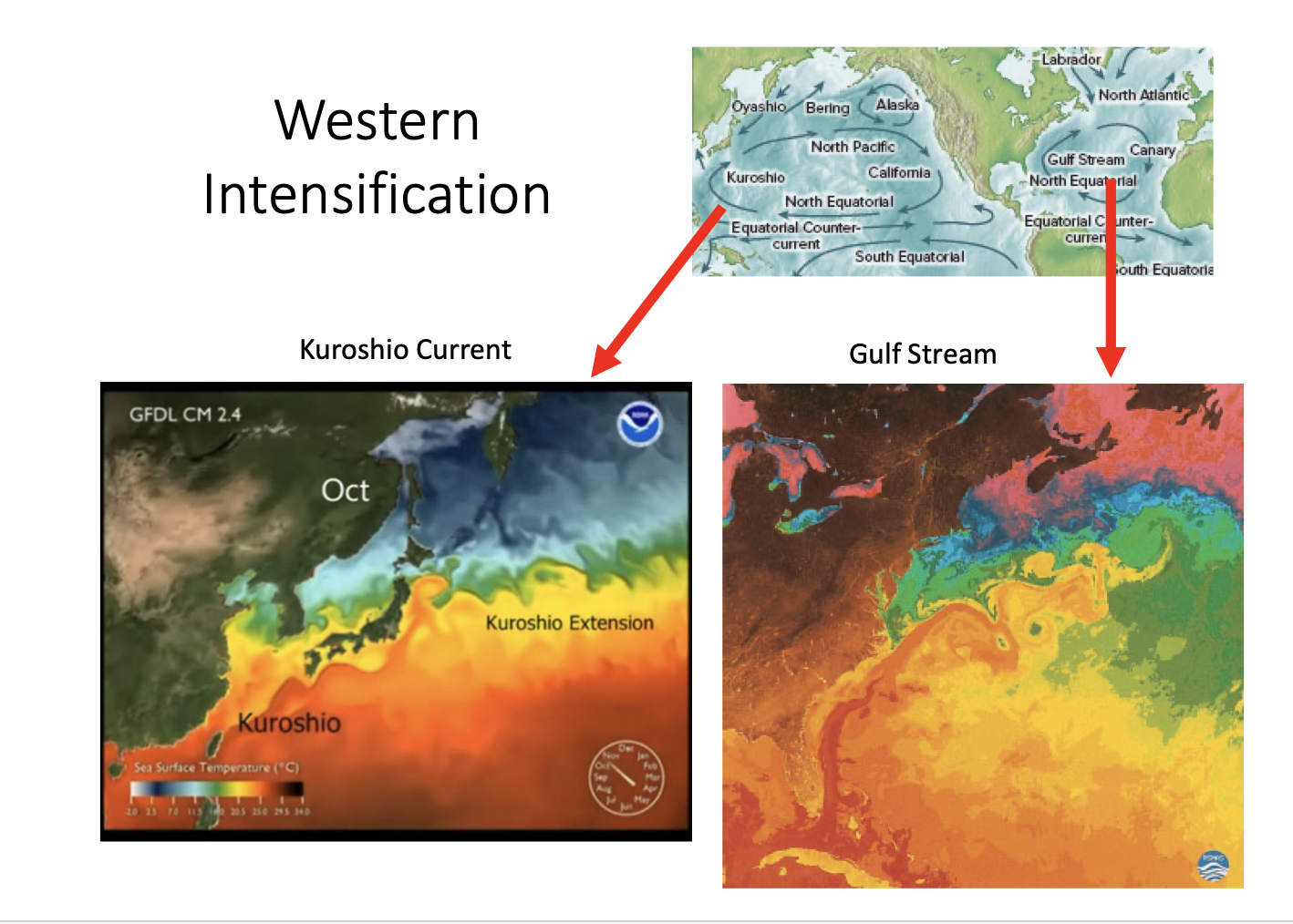
New cards
The Gulf Stream is an example of…
…western intensification
75
New cards
Western boundary currents are ___ __, , and__ _____ than eastern boundary currents
faster, narrower, and deeper
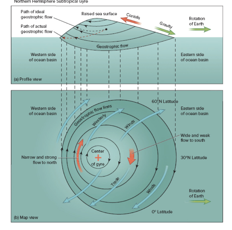
76
New cards

What are these breaks in the current?
A is a cold-core eddy and B is a warm-core eddy
77
New cards
Surface ocean convergence zones are characterized by…
a deepened thermocline and downwelling
78
New cards
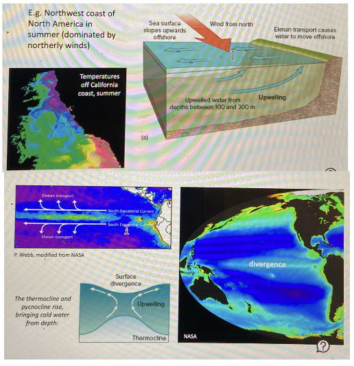
Surface ocean divergence zones are characterized by…
an elevated thermocline and downwelling
79
New cards

This northern hemisphere location along an Eastern Boundary Current is likely characterized by…
…coastal upwelling
80
New cards
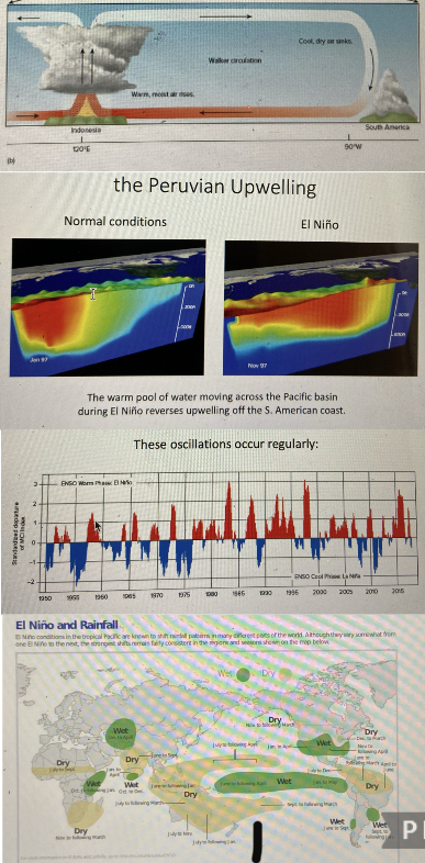
An El Niño is…
…A regularly occurring reversal of the Indonesian Low and South Pacific High, and the flow of warm water across the Pacific from west to east, which deepens the thermocline and enhances upwelling
81
New cards
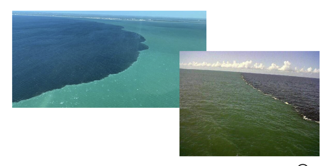
a large body of water that has similar values of temperature and salinity throughout, and the boundary between them, are called…
…a water mass, separated by a front
82
New cards
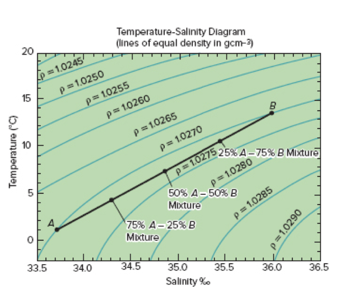
What is the density of water with T=10 and S=35.1?
1\.0270
83
New cards
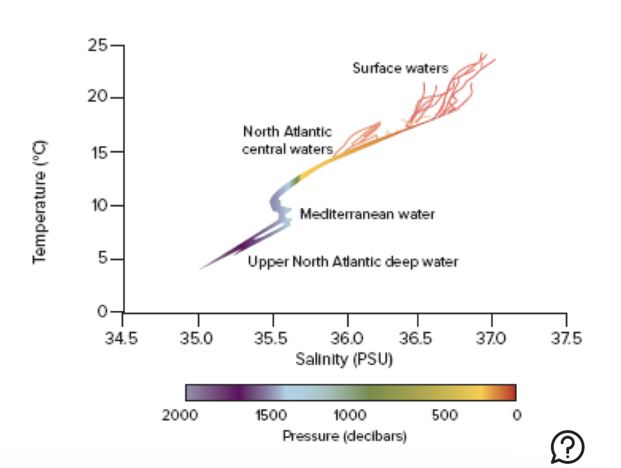
What are the typical values of Mediterranean water?
T=10, S=35.6, P is between 1000-1500
84
New cards
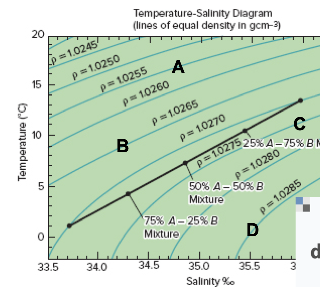
Which of these water masses will reside at the bottom of the water column?
D
85
New cards

Which profile depicts an unstable water column?
C-it will initiate a convection current
86
New cards
What is happening to the water column at this location?
Sinking of bottom water, as surface water gets cold and saltier as it moves towards the poles, and water from lower latitudes comes to replace it via convection currents
87
New cards
All of these are locations of deep water formation except…
…C-no bottom water formation in the pacific

88
New cards
Due to climate change, thermohaline circulation around the globe is….
…weakening
89
New cards
The region of the water column with enough light for photosynthesis is called the…
…photic zone
90
New cards
“benthic” refers to…
…the seafloor
91
New cards
As death increases, light…
…decreases
92
New cards
Which wavelength of light penetrates deepest in ocean water?
Blue
93
New cards
which group of marine organisms are unable to move against the currents?
Plankton
94
New cards
Which group of plankton are autotrophic?
Phytoplankton-conduct photosynthesis
95
New cards
As the size of marine organisms increases, their abundance typically *___ and their surface area:volume ratio* __
decreases,increases
96
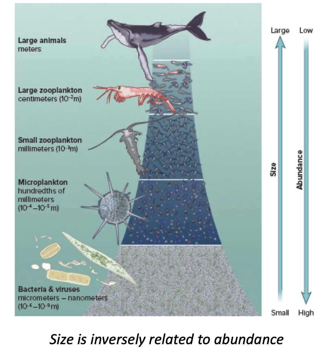
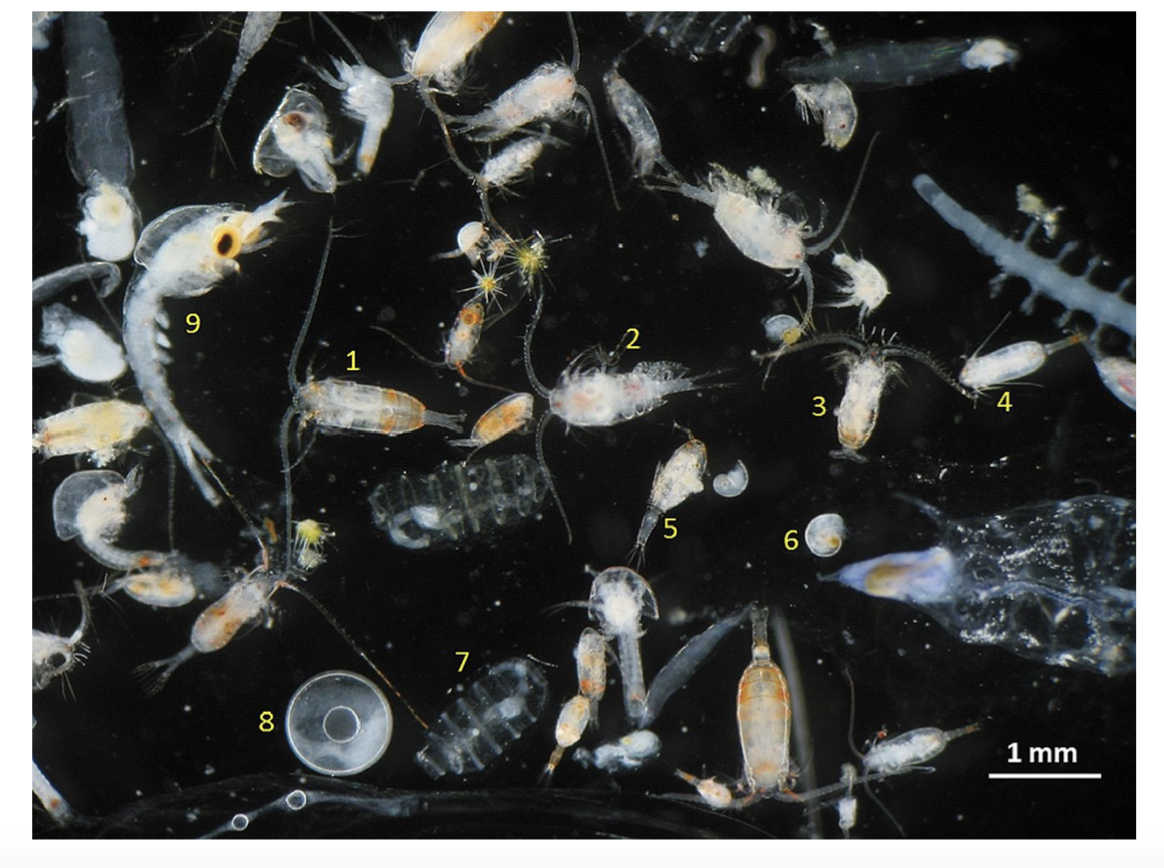
New cards
Which group of marine organisms are able to swim against the currents?
Nekton
97
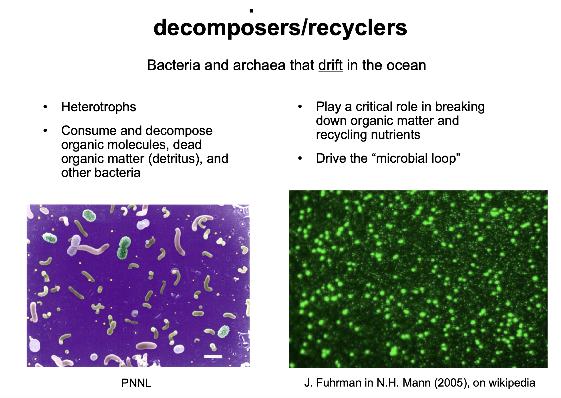
New cards
Which group(s) of plankton are heterotrophic?
Bacterioplankton, zooplankton
98
New cards
Which group are primary consumers in the oceanic food chain?
Zooplankton
99
New cards
Which group are primary decomposers in the oceanic food chain?
Bacterioplankton
100
New cards
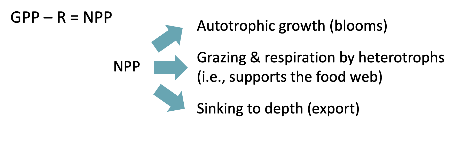
Net primary Production
overall gain/loss of biomass in producers (photosynthesis-respiration)