Unit 3: Topographical Maps
1/16
There's no tags or description
Looks like no tags are added yet.
Name | Mastery | Learn | Test | Matching | Spaced | Call with Kai |
|---|
No analytics yet
Send a link to your students to track their progress
17 Terms
Map Symbols
A symbol is a marking, sign or object that represents something.
Area Symbols
Spaces that are contained within boundaries and are used to represent things like dams and residential areas
Areas can be regular (Shapes like circles, triangles and rectangles) or they can be irregular (Like the shape of a lake)
Point Symbols
Used to represent buildings like shops or schools
Line Symbols
Used to represent structures like roads, rivers and railways
Natural Features
Not man-made
Part of the environment
Occurs naturally
Provides resources like paper, building materials and furniture
Typical Natural Features
The sea, Natural bays, Shores, Islands
Mountains
Rivers, Lakes, Natural dams
Bushes, Forests, Vegetation
Constructed Features
Man-made
Does not occur naturally
Caters to our needs
Eg. Roads help us travel from one place to another easier
Typical Constructed Features:
Roads, Railways, Lines, Airports
Settlements
Dams
Purification Plants
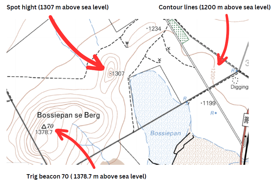
Height Clues
Indicators or marks of heights
Two symbols that represent height are:
Spot heights
Denote the exact height of the land
Shown by a small black dot with a height reading above sea level next to it
Trig beacons
Shown by a triangle
The number above the triangle is the number of the trig beacon while the actual height above sea level is given next to the tringle
Surveyors measure both
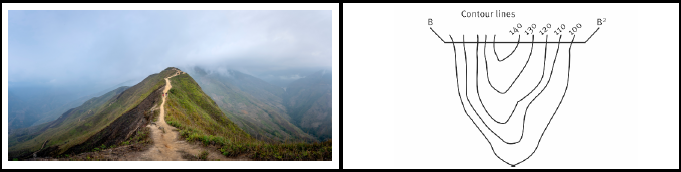
Main height clues are the contour lines
Close together = Steep
Far apart = Gradual
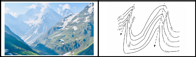
River Valley
A valley formed by flowing water.
It is usually V-shaped.
The exact shape will depend on the characteristics of the stream flowing through it.
Rivers with steep gradients, as in mountain ranges, produce steep walls and a bottom.
Shallower slopes may produce broader and gentler valleys.

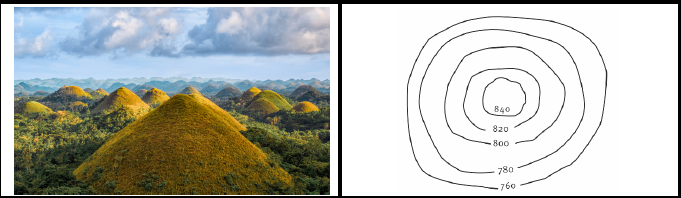
Hill
A hill is a landform that extends above the surrounding terrain.
Hills often have a distinct summit and are generally lower and less steep than mountains.
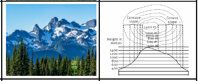
Mountains
A mountain is a large landform that rises up quite abruptly above the surrounding land in a limited area, usually in the form of a peak that can reach quite a high altitude.
A mountain is generally steeper than a hill.
(Mountain ranges can stretch for very long distances.)
Ridge
A ridge is a long, narrow raised land formation with sloping sides, usually formed by the meeting of two faces of a mountain.
Spur
A spur is a long, gently sloping strip of ground that runs down from a hill to lower ground.
Spurs often provide access to and from the high ground, for walkers and for roads.
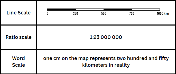
Types of Scales
Line Scales
A line scale on a map is a scale that shows you in specific, accurate-drawn units of measurement how many units of that measurement (e.g. cm) represent how many units of another measurement (e.g. km) on the ground
This means that if you would have taken your ruler and measure the first part of your line scale you would see that it is 1 cm on your ruler. This means that 1 cm on the map equals 250 km in reality.
Ratio Scale
A ratio scale tells us how many units of measurement (usually cm) on the Earth's surface are equal to one unit of the same measurement (cm) on a map.
Word Scale
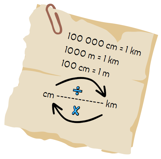
Converting Scales
In some cases, it is easier to use a specific scale and therefore you need to be able to convert scales.
All scales say the same thing but look different.
Eg.
1 : 1 500 000
1cm = 1 500 000cm
1 500 000cm / 100 000 = 15km
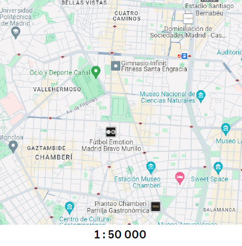
Large - Scale Maps
1 cm on a map represents less ground distance than on small-scale maps
Eg. 1:50 000
Features appear larger and are generally more detailed
Large-scale maps are commonly used to represent ground distances on local maps
Eg. Brits, as shown in the map
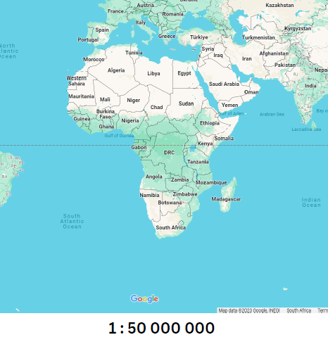
Small - Scale Maps
1 cm on a map represents more ground distance than on large-scale maps
Eg. 1:1 485 000
Features are usually less detailed
Small-scale maps are commonly used represent ground distances on world and regional maps
Eg. South Africa.
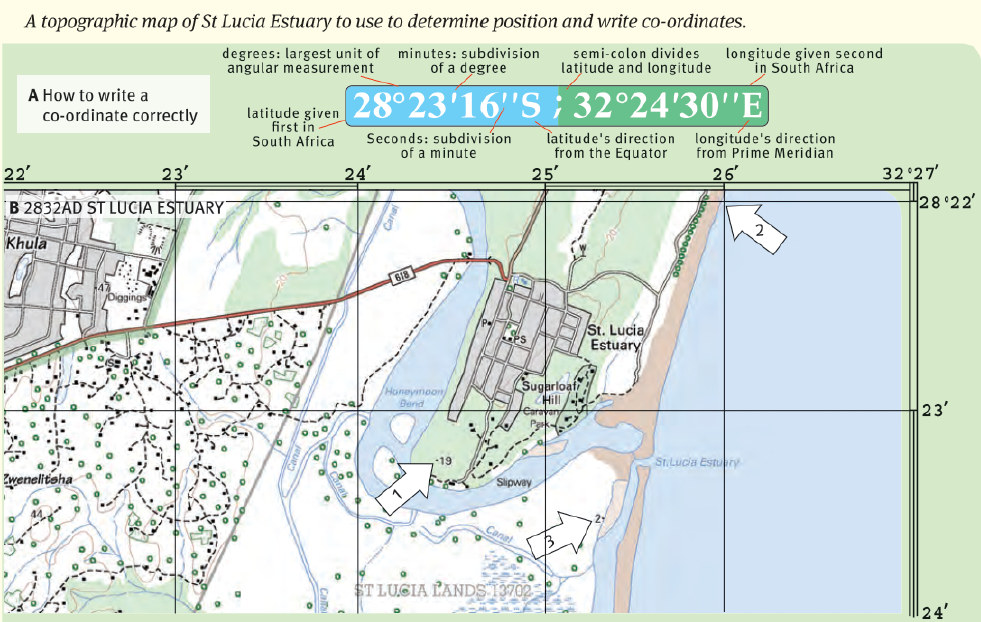
Coordinates
A geographic coordinate is the point at which a line of latitude (horizontal) intersects a line of longitude (Vertical).
The line of latitude is always written first, followed by the line of longitude.
There are 60 minutes in one degree and 60 seconds in one minute.
This detailed breakdown allows every point, place or feature on Earth to be given a position or geographic coordinate.
Degrees (°)
To show degrees, we use this symbol: º.
So, we can write 10 degrees as 10°.
Minutes (')
Each degree is divided into 60 minutes.
To show minutes, we use this symbol: '.
So, we can write 10 minutes as 10'.
Seconds (")
To be even more precise, each minute is divided into 60 seconds.
To show seconds, we use this symbol: ".
So, we can write 10 seconds as 10".