A-level Geography- Hazards
1/231
There's no tags or description
Looks like no tags are added yet.
Name | Mastery | Learn | Test | Matching | Spaced |
|---|
No study sessions yet.
232 Terms
Define natural hazard
Events which are perceived to be a threat to people, the built environment and the natural environment
Are hazards just about the people?
An event will only become a hazard when it is a threat to people. E.g. if a hurricane hit an uninhabited desert island it would not be classed as a hazard.
Is a disaster a hazard?
No,
A disaster will only occur when a vulnerable population (one that will be significantly disrupted and damaged) is exposed to a hazard.
When does the UN believe a hazard becomes a disaster? ( and potential problems)
-10+ people killed
-100+ people affected
-A state of emergency is stated
-International assistance is called for
(only one of these has be acted upon)
Negatives:
-outdated
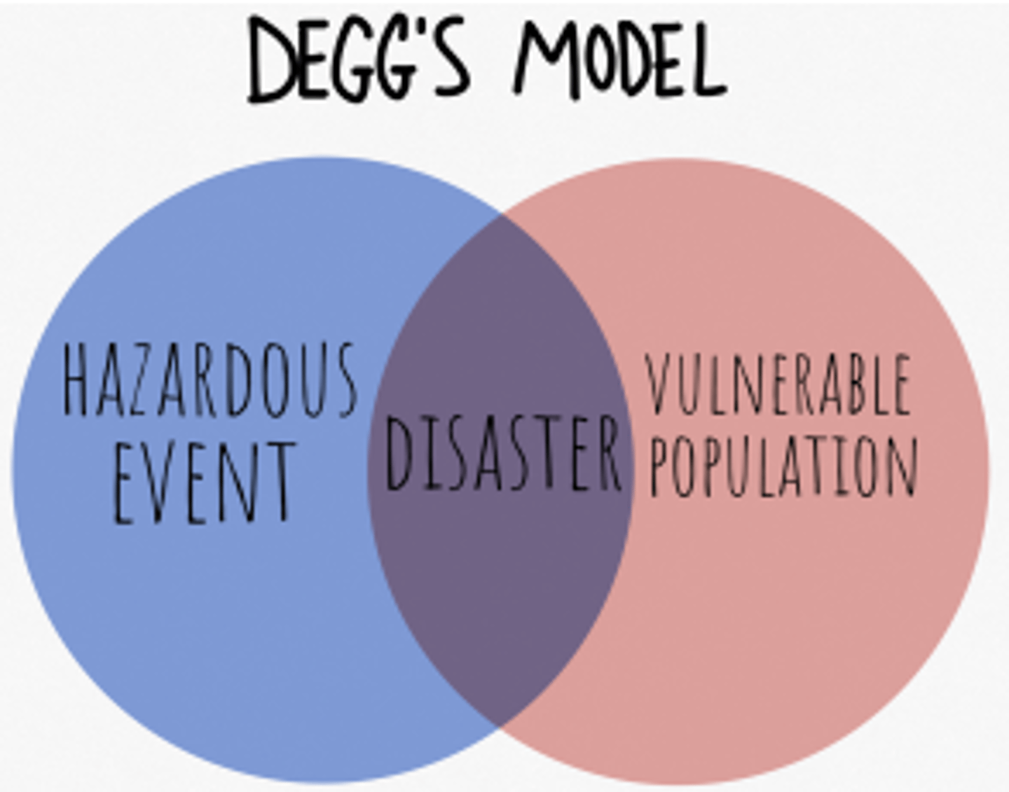
What is Degg's model?
If the population is not vulnerable, the hazard will not have a significant effect, thus the event will not be disastrous.
What are the three major types of geographical hazard?
-Geophysical
-Hydrological
-Atmospheric
Geophysical hazards (examples)
Hazards caused by land processes
-majorly tectonic plates (e.g. volcanoes)
-sometimes external processes of geomorphological origin involving mass movement (e.g. landslides, rockfalls)
Hydrological hazards (examples)
Hazards caused by the occurrence, movement, and distribution of surface and underground water (e.g. floods, mudflows)
Atmospheric hazards (examples)
Hazards caused by processes operating in the atmosphere resulting in extreme weather or atmospheric conditions (e.g. wildfires, storm surges, thunder)
Could these types of geographical hazard be mixed?
Yes, a tropical storm could be classed as an hydrological-atmospheric hazard
Why are some places more vulnerable to hazards? and why?
-rural or urban areas (emergency services are less accessible)
-wealth (health care, more advanced technology, faster early warning system,running water)
-preparedness
-emergency services
- demographic differences (older and younger ages are more vulnerable)
-knowledge of safety procedures
-poverty (limited access to power, resources and infrastructure)
-failing economic, political and social systems
How can people prepare for a hazard?
-Education programs
-Non-perishable foods
-A bunker (specifically for earthquakes)
Why do some people choose to live in a place that suffers from natural hazards?
-Cheaper
-Volcanoes have more fertile land
-Geothermal energy
-Tourism rates
-Low risk hazard
Case study- contrasting wealth countries who experienced a tropical storm
LIC-Typhoon Haiyan (2013)
HIC- Hurricane Sandy (2012)
What happened for hurricane
Sandy?
-Category 3
-High wind strength (129 km/h)
-Located south-east of North America
-Storm surges and landfalls are secondary hazards
Impacts of Hurricane Sandy?
-More than 150 people were killed
-No electricity for days
-Transport links closed due to severe disruption
-total property damaged estimated to be $71 billion
-Petrol was in short supply
-Sewage was released which led to water contamination
-70% of crops were destroyed
What was there response?
-Media raised funds for the victims
-Charities such as Red Cross provided through media events
What happened for Typhoon Haiyan
-Category 5
-Winds of 306 km/h
-Located in the Philippines
-Caused landfalls
Impacts of Typhoon Haiyan?
-weak buildings with loose tiles killed and injured many
-widespread flooding leaving many people were without safe drinking water
-uprooted trees releasing Co2 into the atmosphere and destroying habitats
-transport was cut off for days
-more than 7000 deaths
-power was cut off which made evacuations a longer process
-1.9 million homeless
-Approx $2 billion damaged
-mangroves were damaged
-116,000 received information on how to prepare for a disaster
What did people do in response to Typhoon Haiyan?
-rescues were slow as electricity went out so the rescue process was slower
What are the human responses to risk/hazards
-Fatalism
-Domination
-Adaptation
-Prediction
-mitigation
-management
-risk sharing
What is the fatalism viewpoint?
An optimistic or accepting approach that suggests that people cannot influence or shape the outcome.
-Religious people may believe it is an 'act of God'
What is the domination?
Suggests that hazards are predictable and they can be better understood by scientific research
What is the adaptation?
This perspective takes the view that hazards are influenced by natural and human events and so we can change our lives to reduce the impact.
How can someone predict a hazard?
-using scientific research and past events in order to know when a hazard will take place so warning can be delivered and impacts of the hazard can be reduced.
What is mitigation?
-strategies carried out to lessen the severity of a hazard (sandbags)
What is risk sharing? (example)
-A form of community preparedness, whereby the community shares the risk posed by a natural hazard and invests collectively to mitigate the impacts of future hazards.
-New Zealand is a multi-hazardous environment.
-The Canterbury Earthquake cost the country 20% if it's national GDP. There are attempts to share the risk by insurance investments.
-so strategies can be put in place before the disasters rather than investing more in a clean up.
What models show a countries response to a hazard?
-The park model
-Hazard management cycle
What is the park model?
-The Hazard Response Curve which shows a country or region may respond to a hazard route
-The steepness of the downwards curve depends on the disruption
-The length of the bottom of a curve shows how long they took to react and recover from a disaster
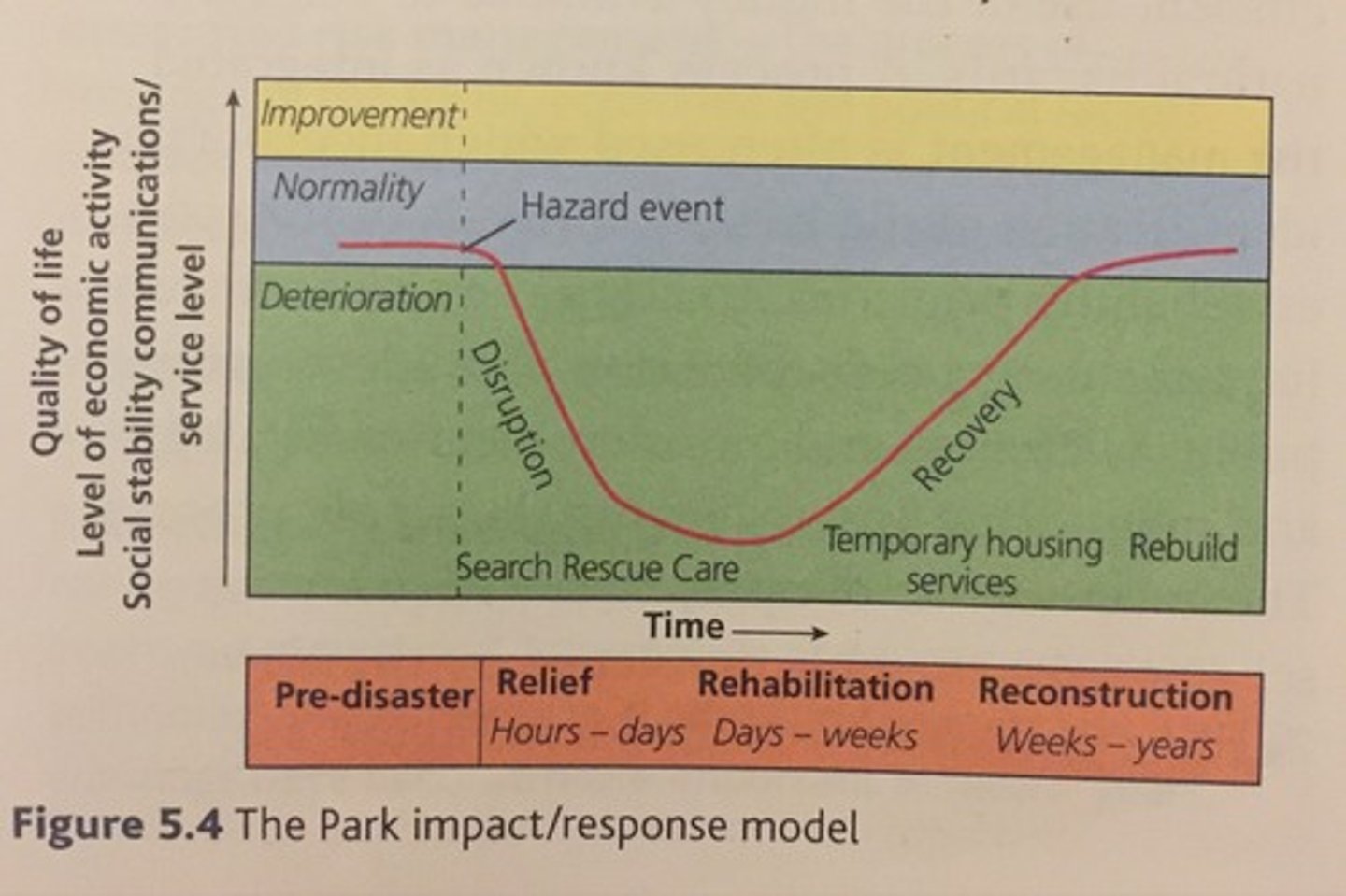
What is the relief phase in the park model?
-Hours-days
-usually a search, rescue and are operations are put into place
What is the rehabilitation phase in the park model?
-days-months
-usually to restore the physical and community infrastructures/services
What is the reconstruction phase in the park model?
-months-years
-where permanent stages are introduced, which is either the same or better quality of life of the original level
What is the hazard management cycle?
outlines the stages of responding to events, showing how the same stages take place after every hazard
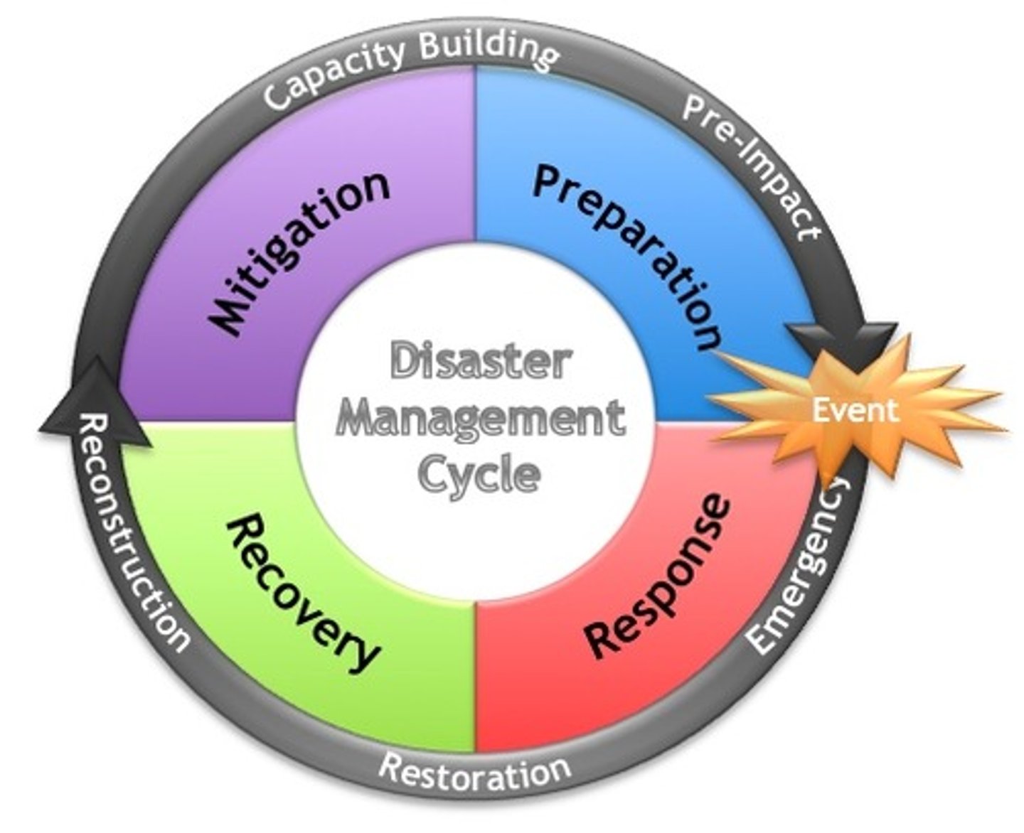
What are the stages?
-preparedness
-(disaster)
-response
-recovery
-mitigation
What are factors affecting trends of a disaster?
-magnitude and duration
-speed of onset (how quickly the hazard occurred)
-development level
-location
-response
-preparation
What are the four layers of the Earth?
-crust
-mantle
-inner core
-outer core
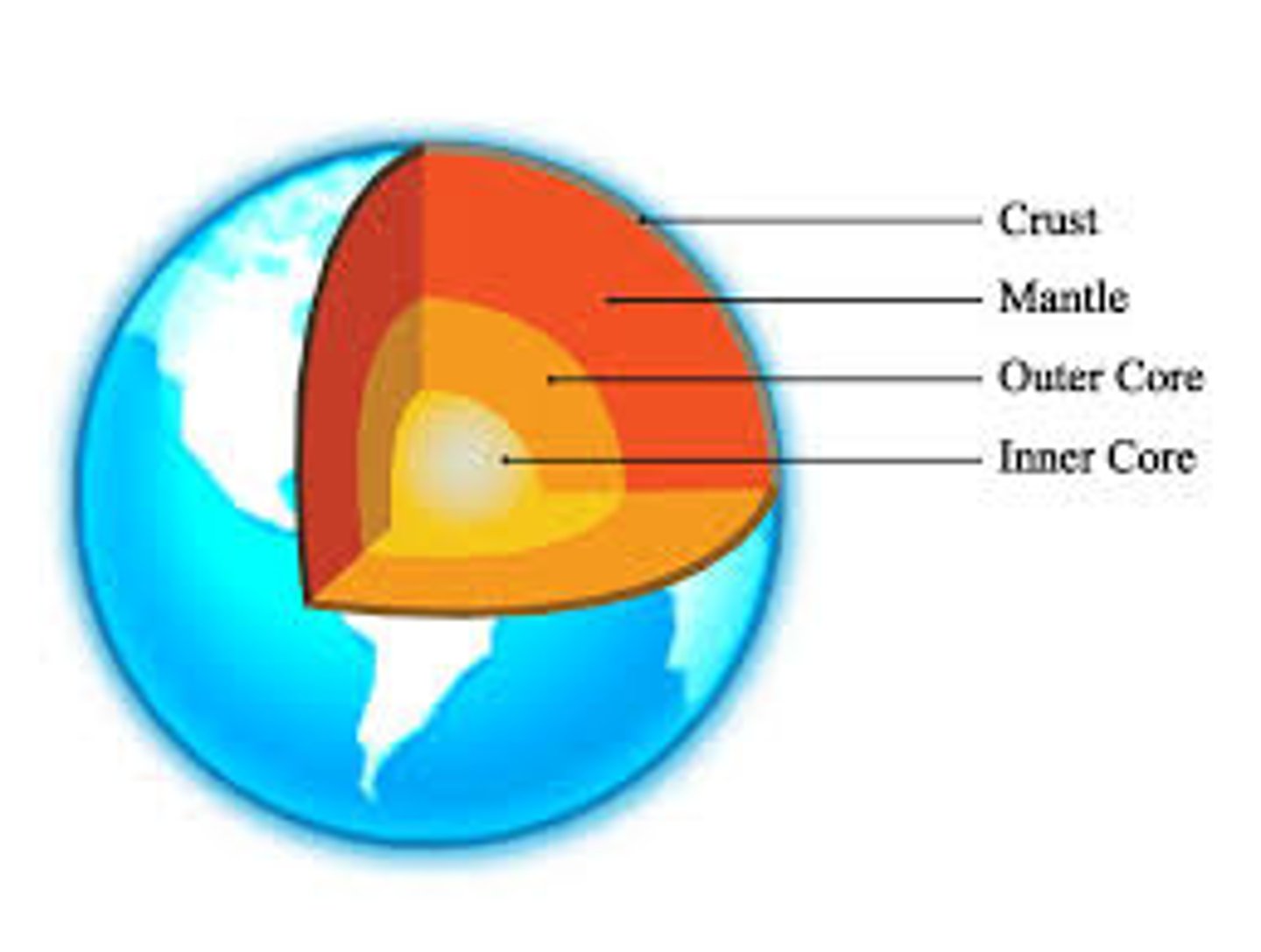
What is the inner core?
-solid ball of iron/nickel
-very hot due to pressure and radioactive decay
-750 miles
What is the outer core?
-semi-molten rock
What is the mantle ?
-mainly solid rock
-top layer is semi-molten magma (asthenosphere)
-18,000 miles
What is the asthenosphere?
-semi-molten layer constantly moving due to flows of heat, convection currents
-movement is powered by heat from the core
What is the lithosphere?
-broken up into plates
-majority is within the mantle and the top being in the crust
What is the crust?
-outer layer of the earth
-top layer of the lithosphere
-includes the oceanic crust and continental crust
Continental crust
-30-70km thick
-over 1,500 million years old
-lighter than oceanic crust
-mainly composed of granite;silicon, aluminium, oxygen (SIAL)
Oceanic crusts
-6-10km thick
-less than 200 million years old
-heavier than continental crust due to pressure from water
-mainly composed of basalt;silicon, magnesium, oxygen (SIMA)
what are the margins for tectonic plates?
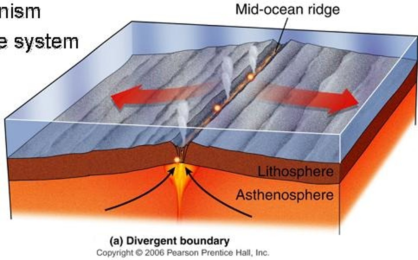
What is a divergent/ constructive plate boundary?
-When the plates move apart then a new crust is formed.
-Can cause small scale earthquakes +underwater volcanoes
-Nazca and Pacific plate
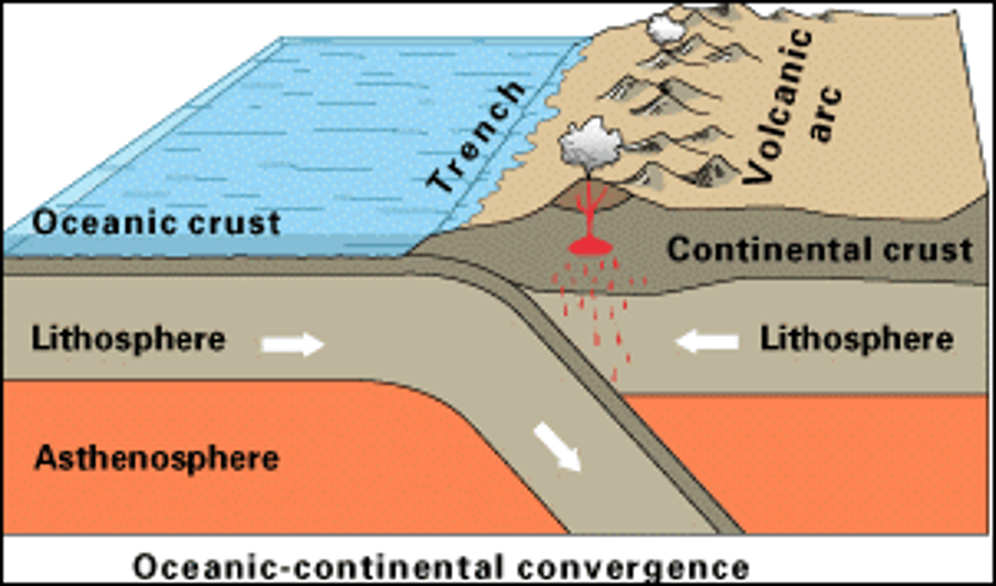
What is a destructive/ convergent plate boundary?
-When the plates move together
-Makes a subduction zone and causes deep earthquakes and volcanoes
-Nazca and South American plate
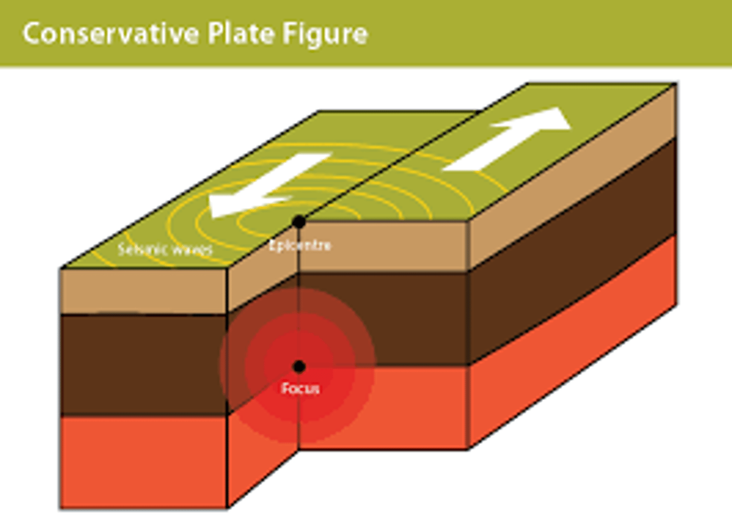
What are conservative/ transform plate boundaries?
-Plates that slide past each other or when one is moving faster than the other
-Lithosphere is neither created or destroyed
-frequent earthquakes, no volcanoes
-Pacific and North America plate
What are landforms associated with plate boundaries?
-young fold mountains
-rift valleys
-ocean ridges
-deep sea trenches
-island arcs
-volcanoes
Young fold mountains
-destructive/ convergent
-Two continental plates collide and neither subduct because both are buoyant so land folds and uplifts
-eg the Himalayas - Indian plate boundary colliding with the Eurasian plate
Rift valley
-constructive/divergent
-two plates pulling apart causing the crust to fall and drop down between faults
-East African Rift Valley- African plate splitting into Nubian and Somali plates
Ocean ridges
-constructive/divergent
-2 OP allowing magma to rise up from inside the earth. This forms new rock once it solidifies
-Mid-Atlantic ridge, Eurasian and North American Plates moving apart
Deep-sea trench
-convergent/destructive
- OP vs OP or CP
-The denser plate subducts below leaving a deep ocean trench
-Mariana trench- pacific plate subducting under the philippine plate (deepest ocean trench)
Island arc
-convergent/destructive
-OP vs OP
-The same process that forms volcanoes on land. But it happens repeatedly until the volcanoes breaks the surface of the water, creating a chain of islands along the subduction zone.
-An island arc is a curved chain of volcanic islands that forms along a destructive (convergent) plate boundary, specifically where two oceanic plates collide.
-Mariana islands
Volcanoes
-both constructive and destructive and hotspots (Hawaiin islands )
-OP vs CP
-The denser oceanic plate subducts under the continental plate and is driven down into the hot asthenosphere/mantel. Subducted plates melt due to heat, which causes them to rise through the crust where it reaches the surface
and cools
How old is the earth?
4.6 billion years old
What is the plate tectonic theory?
-In the 17th century Francis Bacon noticed that the contentment's fit together very well
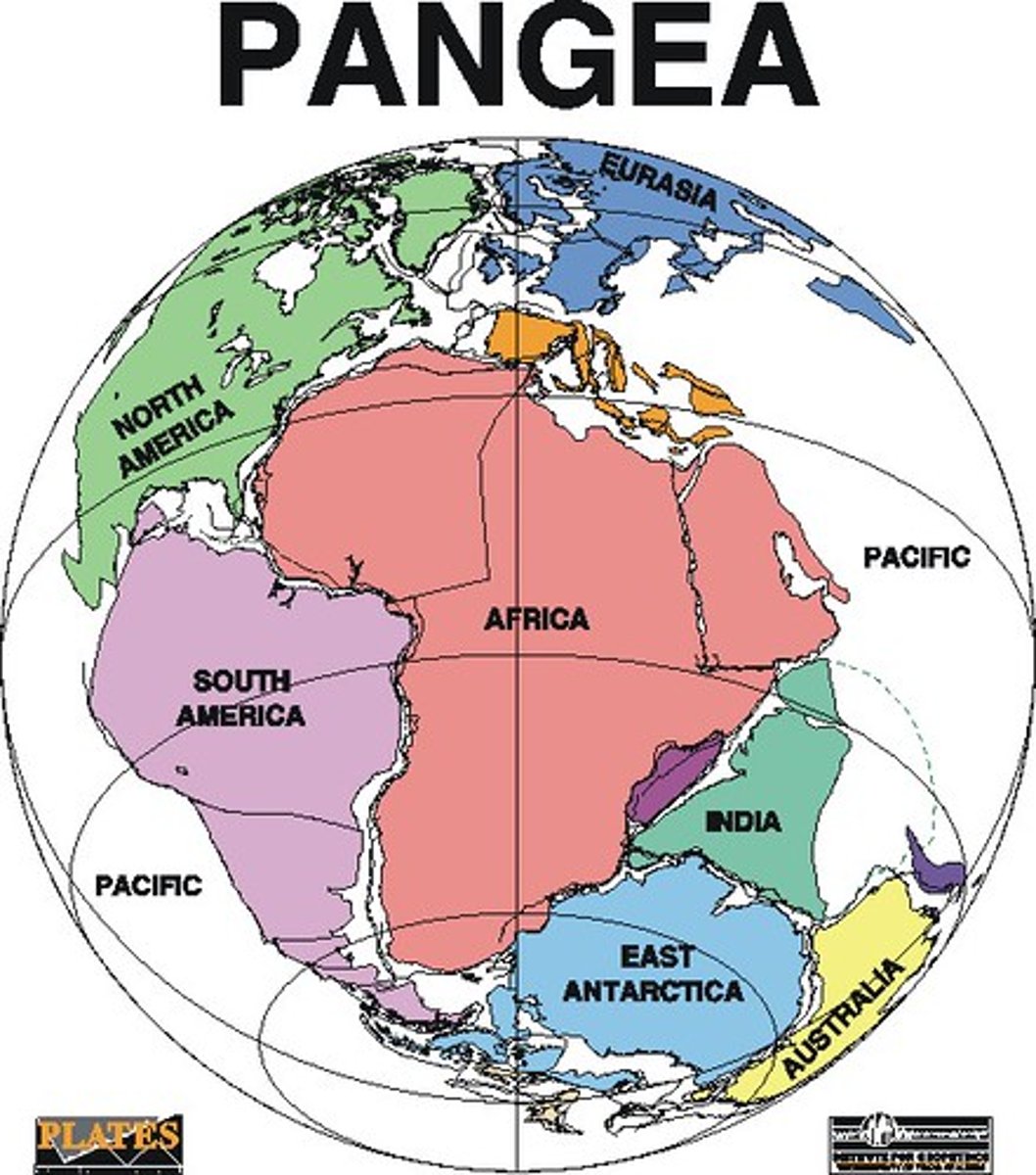
-In 1912, Alfred Wegner published his theory that a single continent exited about 300 million years ago. He named this Pangea.
What are the theories supporting continental drift?
-Glacial deposits
-Geological fit
-Fossil evidence
-tectonic fit
-jigsaw fit
-Frederick Vine and Drummond Matthews theory
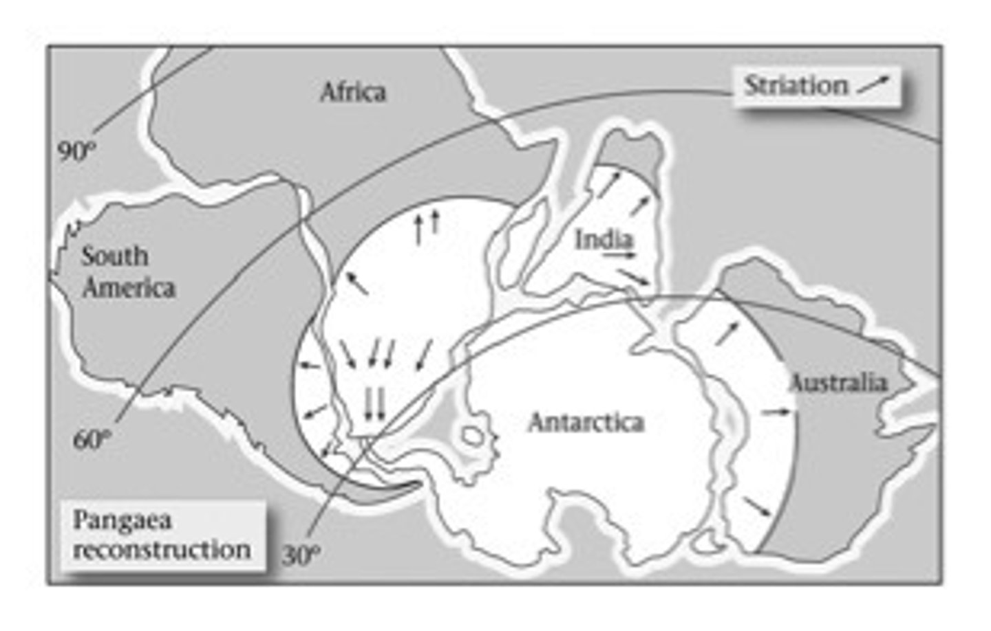
Glacial deposits
-Today glacial deposits (the settling of sediments left behind by a moving glacier) formed during the Permo-Carboniferous period ( an ice age that occured about 250 million years ago) are found on Antarctica, AFrica, South America, India and Australia
-If continents haven't moved this would suggest sheets extending from the south pole to the equator, which is unlikely as the Uk would have been at the equator at this time yet has coala nd limestone deposits.
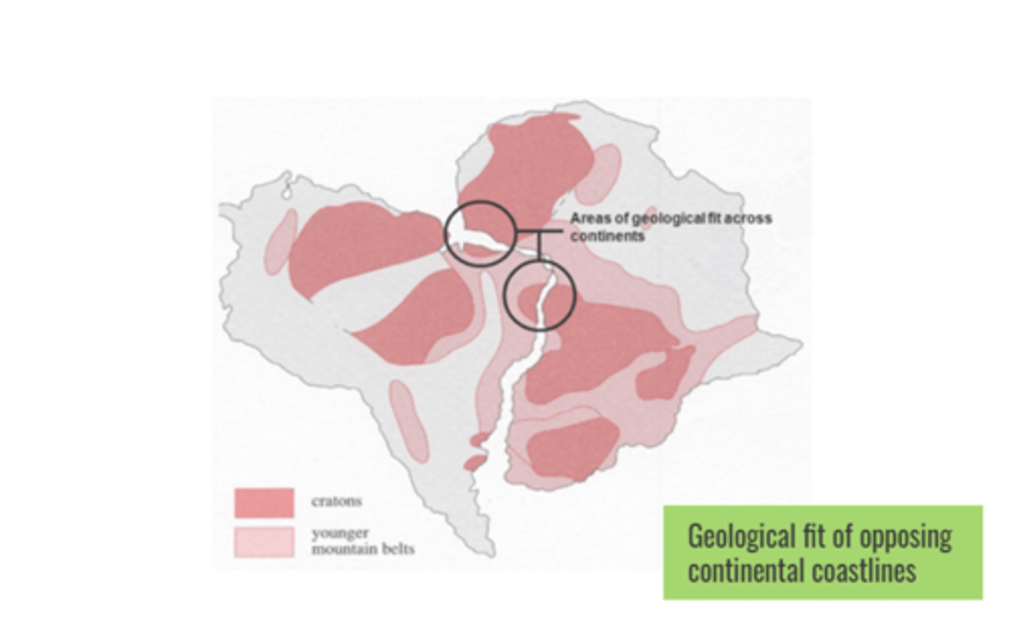
Geological fit
-The geology of South America and West Africa was mapped from over 2,000 million years ago which revealed that the ancient rock were continuous from one continent to another
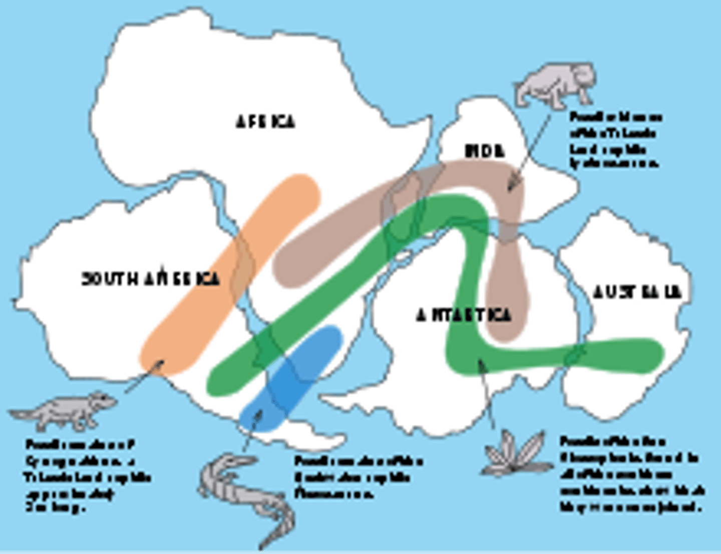
Fossil Evidence
-Fossils have been found on separate continents, suggesting the continents were once joined.
-If continental drift has not occurred alternative explanations would be:
1. the species evolved individually on separate continents, contradicting Darwin's theory of evolution
2. They swam to the other continents in breeding pairs to establish a second population (what about plants?)
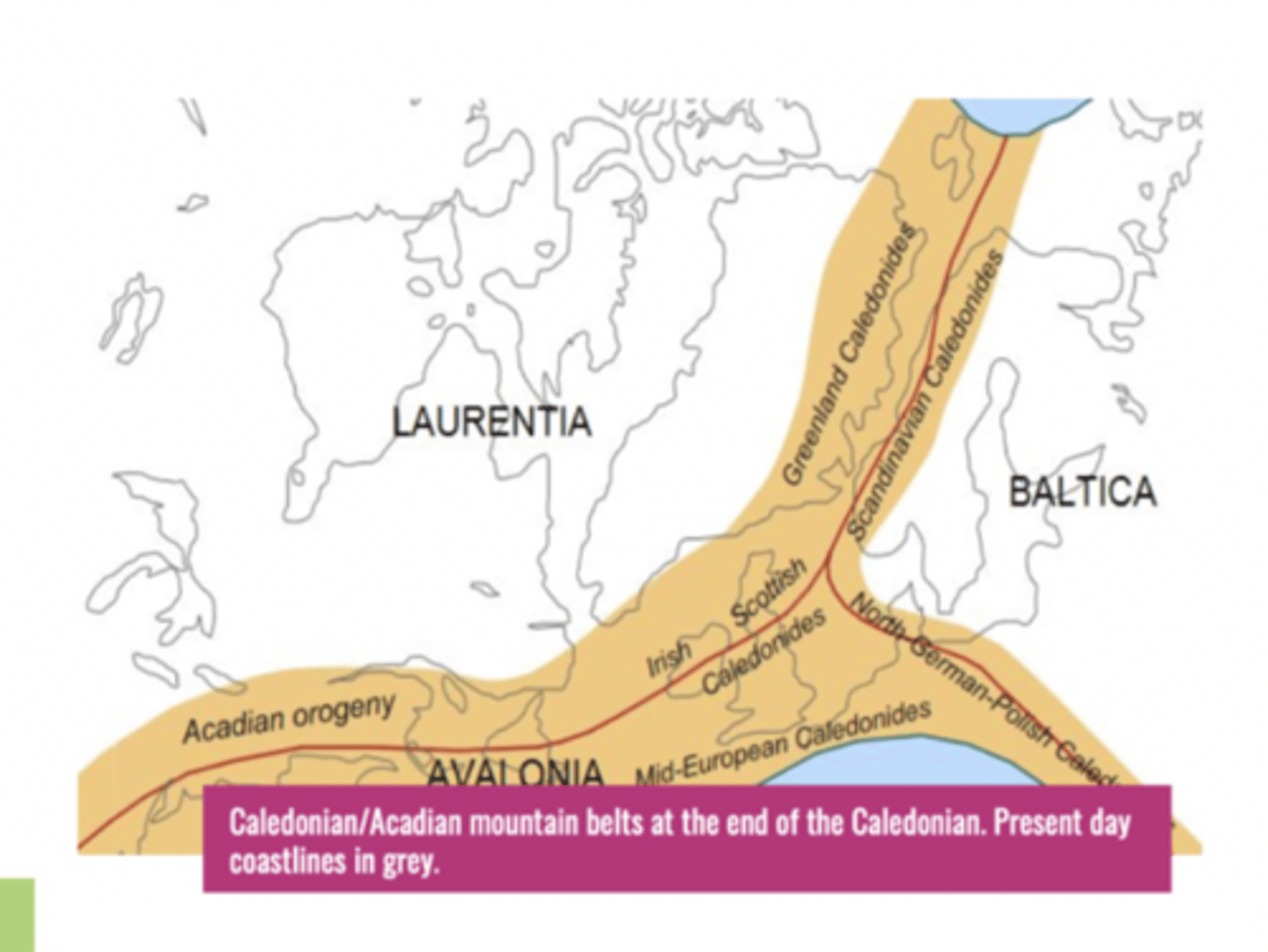
Tectonic fit
Fragments of an old fold mountain belt between 400 and 450 million years ago were found on separated continents today.
-The caledonian fold mountain belt are found in Greenland, Canada, Ireland, England, Scotland and Scandinavia. When reassembled they form as continuous landscape of fold mountains
Jigsaw fit
-The similarity in outline of the coastlines of eastern South America and West Africa has been noted for some time.
-This is matched at a depth of 1,000 meters below current sea level.
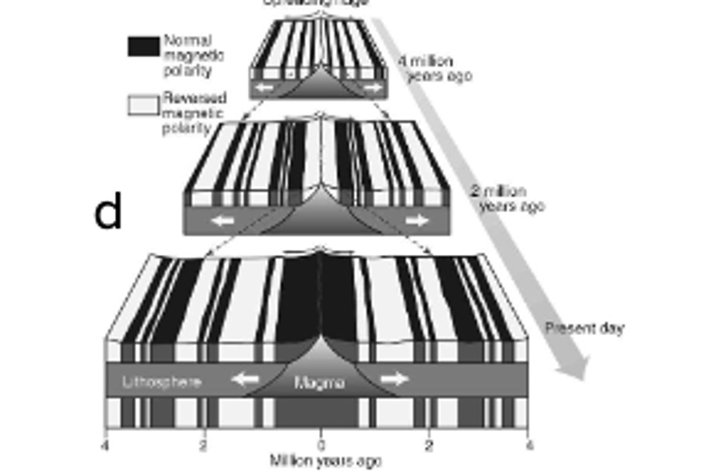
Frederick Vine and Drummond Matthews theory
-Their work looks at the patterns of magnetic stripes on the ocean floor. There is a symmetrical pattern of stripes indicating that the Earth's magnetic field is switching direction over time
-Vines and Matthews noticed there was a symmetrical pattern of magnetic striped, this proves mid-ocean ridges are created
What theories explain the movement of plate tectonics?
-ridge-push (gravitational sliding)
-slab-pull
-convection
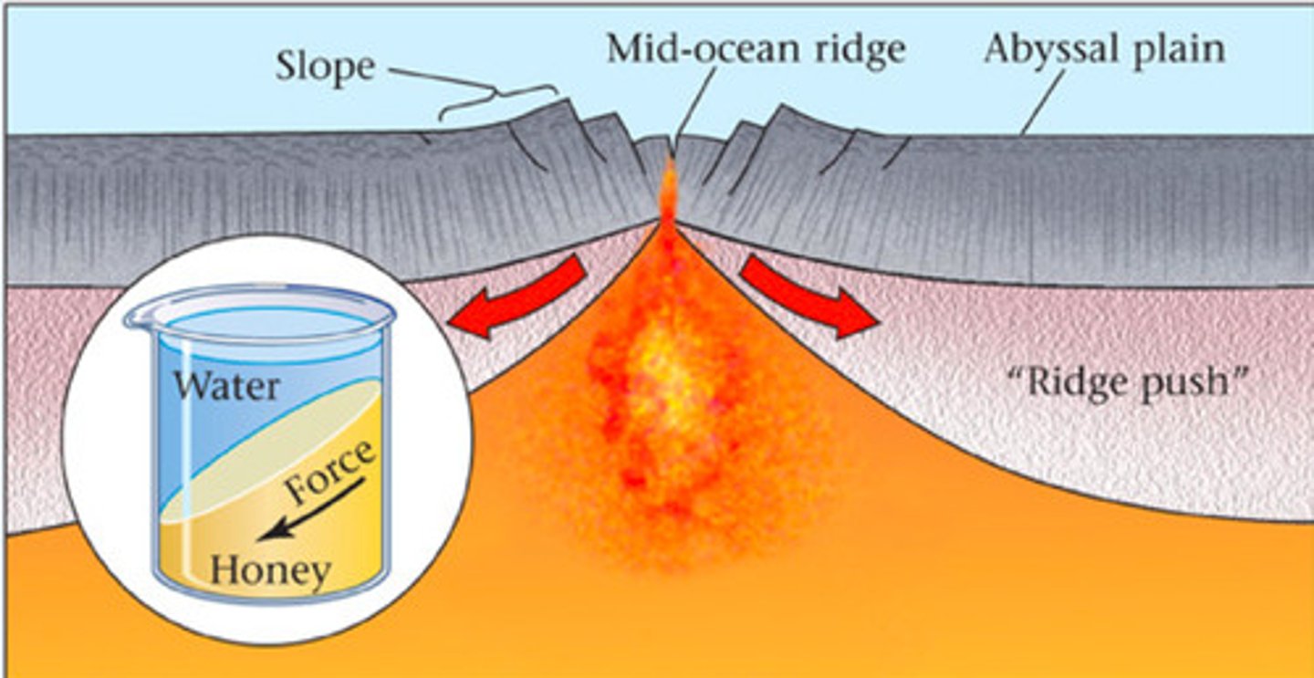
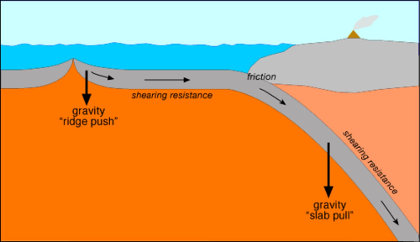
Ridge-pull evidence
-Two tectonic plates separating which is filled in by mantle and then cooled separating the area.
-The mid-Atlantic ridge
-The crust either side suggested the sea floor was spreading
Slab-pull evidence
-When a plate subducts, the plate sinking into the mantle pulls the rest of the plate (slab) with it, causing further subduction.
-The huge oceanic trenches, where large areas of ocean floor were being pulled down in a process known as
Convection currents
-The tectonic plates move due to convection currents in the asthenosphere which push and pull the plates in different directions
-Convection currents are caused when less dense magma rises, cools then sinks
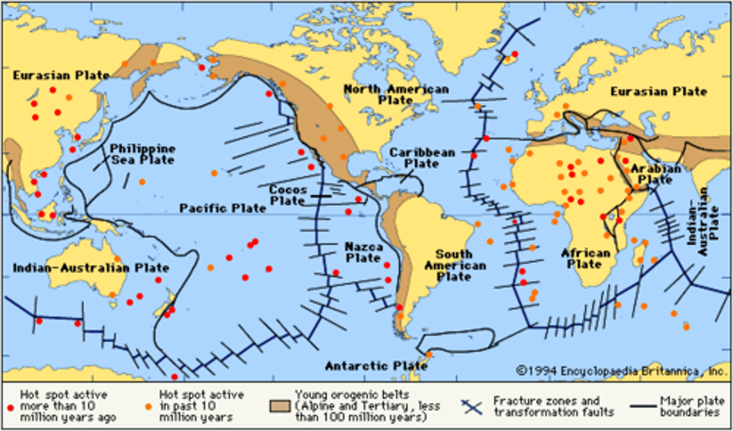
What are magma plumes?
-When the mantle rise and burn through weaker parts of the crust.
-This can create volcanoes and islands .
-The plume stays in the same place but the plates continue to move , which sometimes causes a chain of islands
-For example, Hawaii
What are volcanoes?
-Volcanoes occur on plate boundaries where plates melt and magma erupts through a plate. Alternatively, they may occur on hotspots too.
-Volcanoes are vents in the earth's crust through which lava, tephra (ash, dust and fragments of material produced in a volcanic eruption) and gases erupt
How can we measure the size of a volcano?
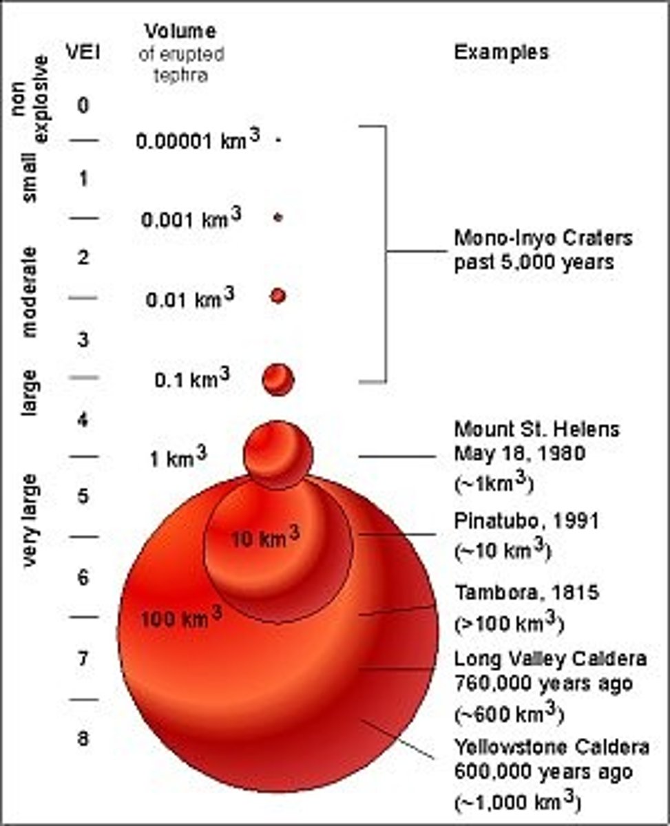
-VEI
What is the VEI?
-Volcanic Explosivity Index
-The relative measure of the explosiveness of volcanic eruptions by measuring the volume of erupted material
What factor changes the reflection of the material that is erupted?
The shape of the volcano, type of cone
What are the different shapes of volcanoes?
-Shield volcano
-Composite volcano
-Fissure volcano
-Dome volcano
-Ash-cinder volcano
-Caldera volcano
What is a shield volcano?
-gentle slope and very wide
-thin, runny lava which moves longer distances before it cools.
-All the lava escapes through one large vent which means lots of lava reaches the surface
-divergent/constructive
-more common
What is a composite/stratovolcano volcano?
-Steep sides with a narrower base
-thick/slower lava
-Lava escapes through a number of vents and the parasitic cones
-Violent eruptions, which force volcanic bombs out of the vent causing lahars
-destructive plates/convergent
What is lahars mudflow?
-where ash/lava mixes with water/snow flow like wet concrete
What is an active volcano?
Erupted in recent history/memory
What is a dormant volcano?
Volcanoes that have erupted in history and are expected to erupt again in the future
What is an extinct volcano?
-Will not erupt again
Are these reliable?
-It is not unknown for dormant or extinct volcanoes to erupt
-AD 79 the Vesuvius erupted
What type of volcanoes often become extinct?
-Ones created from hot spots as the lithosphere moves over the plume
What are the different types of lava?
-Basaltic lava
-Andesitic (intermediate) lava
-Rhyoliti (acid) lava
Basaltic lava/ basic lava
-hot (1200'), runny, low viscosity
-low silica content
-flows as rivers of molten rock as takes longer to cool
-keeps its gas content so is more mobile
-produces extensive, gently sloping land forms
-realitivly gentle but frequent eruptions
Where is basaltic lava/ basic lava found?
-found at constructive plate margins
-hot spots- hawaii
-fissures along Mid-Atlantic Ridge
Andesitic acid lava
-cooler (800'), flows slower
-Viscous
-higher silica content
-flows shorter distances as soon as cools
-looses gas quickly so becomes more viscous
-steep-sided
-less frequent eruptions but are violent because of gas build up
-Pyroclastics :ash,rock, gases, steam and lava ejected
Where is Andesitic acid lava found?
-found at destructive margins where oceanic crust is destroyed, melts and rises
-subduction zones
-island arcs
How do composite volcanoes change overtime?
-Taller due to slower moving lava
-Frequent eruption
How do shield volcanoes change overtime?
-Wider and flatter due to faster moving lava
How scale measures volcanoes?
-VEI scale (volcanic explosive Index)
-This measures the volume of erupted material
-8 characteristic marks on the scale that x10 each stage.
-Hawaiian and Icelandic eruptions are commonly scale 1
-Yellowstone would be classed as scale 8
Case study 1- Volcanic hazard
-Soufriere Hills, Montserrat
-Located in the Caribbean
-1997
-19 deaths
-Airport was 5.5km away and was in the direct path of the main pyroclastic flow and was completely destroyed
-Predicted as repetitive earthquakes and dome deformation
Case study 2 -volcanic hazard
-Popocatepetl
-Located in the Mexico City in the center of the Mexican central volcano belt
-In one of the most densely populated populated areas in the world. AT the time 20 million people lived within a 80 km radius of the volcano
-Evacuate 75,000 people
What is the plate tectonic theory?
-Builds on Alfred Wegener's observations of continental drift
-In 1960, we obtained sufficient data to establish the truth of the Earth's movement
-Now it is widely accepted that oceanic crust and continental crust cover a mass of molten rock ( upper mantle) and convection currents are the main force for the movement of tectonic plates
-Besides this scientist question why hot spots occur in the middle of a tectonic plate
Who explained these theories?
-Tuzo Wilson
-Foulger
Tuzo Wilson's theory
-1963
-Static radioactive elements in the mantle create plumes of magma
-The plumes pushes upwards; pressure drops and then it become molten , melting and pushing through the crust above.
-This lies at a fixed position below the plate
-As the plate moves over this hot spot it creates a succession of volcanoes that migrate along the plate
Foulger's theory
-2003
-Faults in the crust allow plumes of magma through the crust
-Weaknesses in tectonic plates create hot spots.
-She claims tectonic plates have scars from divergence
General beliefs now
-Radioactive decay creates high temperatures which heat the upper mantle/lithosphere
-Plumes of magma rises and burns through the Earth's lithosphere
-The hotspot remains stationary while the overlaying plate remains stationary
Oceanic vs continental hot spot activity
C-explosive, higher viscosity
O-less explosive, less viscosity
Case Study - hotspots
-The Hawaii Islands
-As the Pacific Plate drifted towards the northwest the islands were located above the hotpot creating volcanoes
-A sharp bend in the motion of the pacific plate occurred around 43 million years ago, possibly related to the collision of India and Asian continent which began about the same time
-The plate is continuing to move north west, meaning new volcanoes will be produced
How do volcanic eruptions cause hazards?
-Tephra and ash clouds
-Lava flows
-Lahars
-Volcanic Gases
-Acid Rain and climate change
-Pyroclastic flows
-Landslides
-nuées ardentes