12-13 Soil characteristics and classification
1/36
There's no tags or description
Looks like no tags are added yet.
Name | Mastery | Learn | Test | Matching | Spaced | Call with Kai |
|---|
No analytics yet
Send a link to your students to track their progress
37 Terms
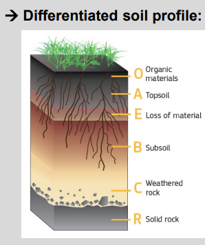
Differentiated soil profile
Soil production vs soil formation
Soil production = creation of soil material from bedrock
→ driven by chemical weathering + bioturbation
→ produces regolith / saprolite (weathered rock)Soil formation = development of soil horizons
→ driven by translocation, transformation, OM accumulation, structure formation
→ can act on bedrock-derived material or sedimentsKey distinction
Soil ≠ just decomposed rock
Soil can form on pre-existing sediments (age & provenance matter)
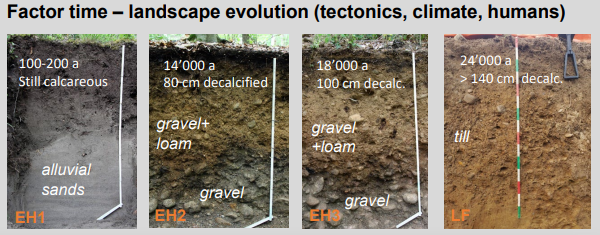
Rates matter
Typical production rates: ~10–100 mm/ka
Balance between:
Erosion > formation → soil loss
Erosion = formation → steady state
Erosion < formation → soil thickening
Controls
Climate
Biota (bioturbation, roots)
Parent material
Time
Human activity (e.g. agriculture increases erosion)
Core idea:
Soil thickness and persistence depend on the balance between soil production and erosion, while soil properties depend on formation processes over time, not just rock weathering.
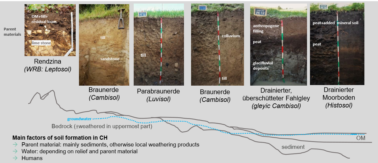
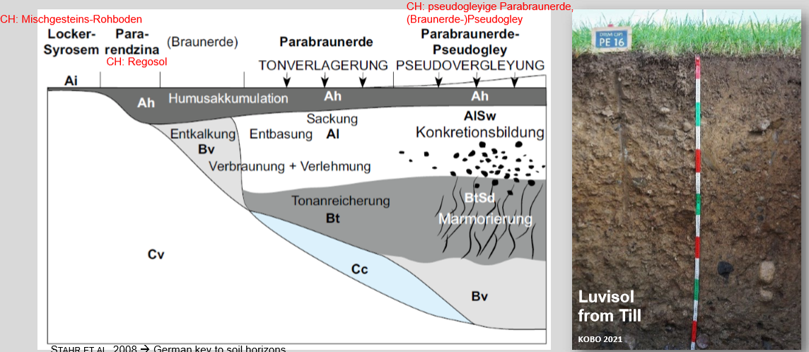
Typical CH soils
In Switzerland, soil types mainly reflect parent material + water regime (relief & groundwater), with strong human influence.
Parent material dominates (mostly sediments: till, colluvium, fluvio-glacial, peat)
Relief & groundwater control drainage → gleyic vs well-drained soils
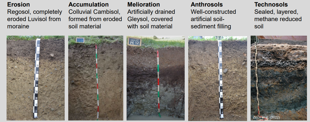
Human activity (drainage, filling, peat addition) strongly modifies soils
Result: strong soil variability over short distances (Leptosol → Cambisol → Luvisol → Gleysol → Histosol)
Core idea: soil pattern follows landscape + sediments, not just bedrock
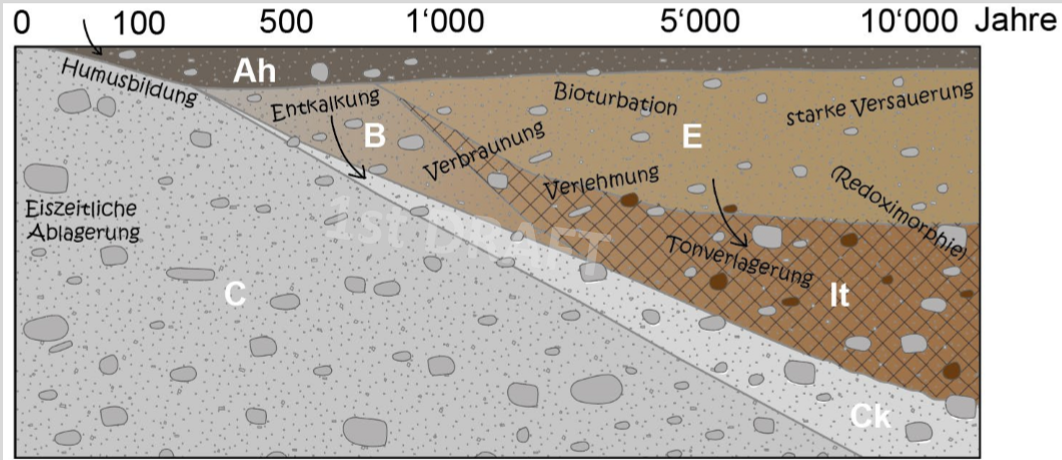
Luvisol Engelhalbinsel
1) Horizon vs. layer (core concept)
Soil horizons = formed by pedogenesis (Ah, E, Bt/It, Ck)
Geological layers = depositional history (fluvial/aeolian loam, gravels)
→ Soil properties ≠ original sediment only
2) Dominant process: clay translocation
E horizon: clay eluviation (loss)
Bt / It horizon: clay illuviation (accumulation)
→ Diagnostic feature of Luvisols
3) Carbonates control soil evolution
Ck horizon: carbonate-rich gravels/sands
Early stage: decalcification from top downward
pH increases with depth due to carbonates
4) Vertical differentiation with depth
Ah: humus accumulation, bioturbation
E: bleaching, loss of clay and Fe
Bt / It: clay enrichment, stronger structure
Ck: parent material with secondary carbonate
5) Time dimension
Soil developed over ~10–15 ka (post-glacial)
Progressive sequence:
Humus formation
Decalcification
Clay translocation
Redox features locally
6) Why this example matters
Shows how:
Pedogenesis overprints geology
Same parent material → different horizons
Luvisols record both transport (sediment) and in-situ soil processes
Major horizons (International WRB, German Ka5, Swiss KLABS)
International → has soil worldwide
KA5 (Deutschland) used in most textbooks
CH more used by practitioners, people who work in the field, agriculture
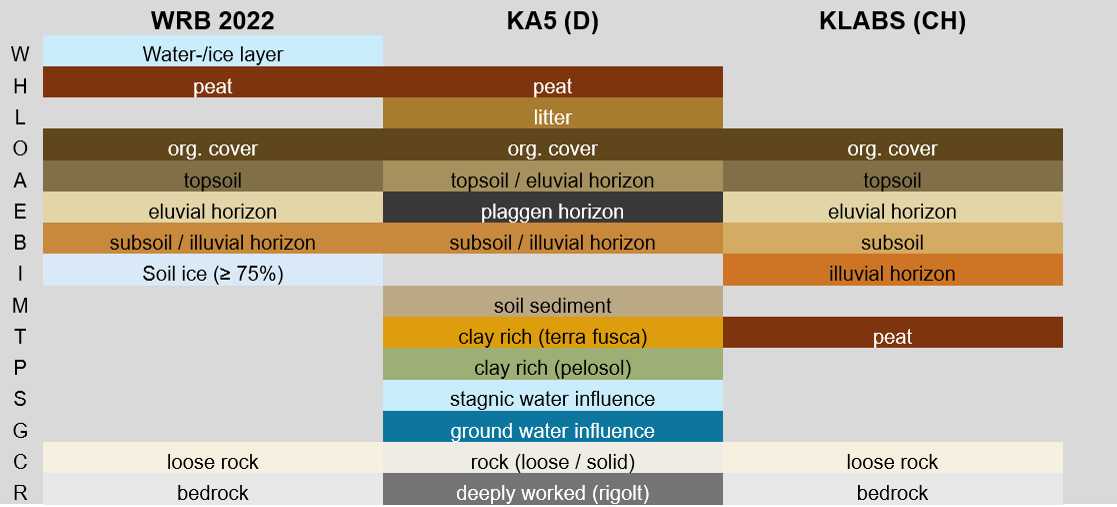
Major horizons to know
| WRB 2020 (int) | KA5 (D) | KLABS (CH) |
H | peat | Peat |
|
O | Organic cover | Organic cover | Organic cover |
A | Topsoil | Topsoil/eluvial hor | Topsoil |
E | Eluvial horizons | Plaggen | Eluvial horizons |
B | Subsoil/illuvial | Subsoil/illuvial | Subsoil |
I | Soil ice (>70%) |
| Illuvial |
T |
| Clay rich (terra fusca) | Peat |
C | Loose rock | Rock (loose and solid) | Loose rock |
R | Bedrock | Deeply worked (rigolt) | Bedrock |
Subordinate horizons to know
| WRB 2020 | KA5 | KLABS |
f | permafrost | Moder zone | Moder zone |
g | Stagnic conditions | Stagnic conditions | Moderately redoximorph |
h | Humic (insitu/illuvial OM) | Humic (insitu/illuvial OM) | Humic (Oh, Ah, Ih) |
l | Capillary redoximorphism | Eluviation clay | Litter |
r | reduced | reduced | Reduced |
s | Illuvial sesquioxides | Illuvial sesquioxides |
|
t | Clay illuviation | Clay illuviation B /shrinked H | Clay enriched |
w | weathered | Conducting stagnant water | weathered |
Parents material in pedology (german approach)
Parent materials are grouped by physicochemical properties, not only by rock name
Silica-rich parent materials
(granite, gneiss, sandstone)
Texture: light, sandy to sandy loam
Drainage: well-drained
Chemistry: acidic
→ Favors leaching, weaker buffering, podzolisation possible
Carbonatic parent materials
(limestone, dolomite, marble)
Soil depth: often shallow
Texture: fine-grained
Chemistry: neutral to alkaline, strong buffering
Organic matter: humus-rich
→ Slower acidification, carbonate control dominates pedogenesis
Claystones
(claystone, shale, schist)
Texture: heavy (clay loam)
Drainage: poor
Chemistry: often acidic
→ Waterlogging, redox processes, strong structure effects
Marls (clay + carbonate mix)
(marlstone, lime mica schist)
Drainage: moderate
Texture: well-structured, balanced
Chemistry: neutral → slightly acidic
→ Transitional behavior between clayey and calcareous systems
→ Includes calcareous sediments (moraine, loess, glaciofluvial)
Silica series
Granit/Gneiss rich in silica, soils form by humus accumulation, bases washed out
Soil acid, bleaching and organic matter goes down
Lime series
Limestone mainly calcium-carbonate
Karst, Limestone is dissolved, some dirt in there
Brown clay takes lot of time
Residual loam is what remains when limestone dissolves, mainly formed by clay
Clay series
Claystone
Surface goes up because of swelling of clay
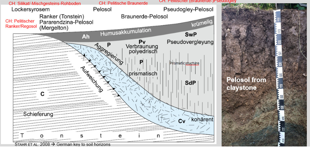
Marl (mergel) series
Not on Mergel but on loose material → Moraine, Löss… → contains a bit of carbonate (20-40%), has carbonate, silica and clay
No redox, pure luvisol
Important to understand the three main parent material and the mix
Initial signs of pedogenesis
Interaction between lichen and granite in glacier forefield
Weathering rind of granite
Not a soil but some signs that a soil could start to form
Humification and bioturbation
Main soils → Regosol and Chernozem
Key processes:
Humification: accumulation and stabilization of organic matter
Bioturbation: mixing of soil by roots and soil fauna
Main effects:
Dark, humus-rich topsoil
Strong aggregation, good structure
Weak horizon differentiation due to mixing
Controls:
Vegetation → OM input
Climate → decomposition vs. accumulation
Parent material is secondary for morphology
Core idea:
The intensity and duration of humification and bioturbation control topsoil development: weak → simple soils; strong and long-lasting → thick, fertile, well-mixed soils
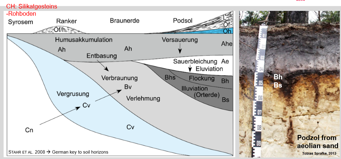
Brunification/Loamification → Cambisol/Braunerde
Key pedogenetic processes:
Brunification: oxidation of Fe²⁺ to Fe³⁺ → formation of brown Fe-oxides/hydroxides (e.g. goethite), coating mineral grains
Loamification (Verlehmung): chemical weathering of silicates → production of fine earth (silt + clay), weak clay formation but little translocation
Soil development:
Moderate chemical weathering, often after decalcification (if carbonates were present)
No strong eluviation/illuviation → processes mainly in situ
Environmental setting:
Temperate climates, good drainage
Common on weakly weathered sediments or weathered rock
Core idea:
Cambisols represent an intermediate soil stage formed by brunification and loamification, showing clear weathering but little vertical material translocation.
Cambiso/Braunerde horizons
Ah horizon
Topsoil with humus accumulation
Darker color, high biological activity
Rooting zone, mixing by bioturbation
Bw horizon (diagnostic horizon)
Weathered B horizon
Brown color due to Fe-oxide formation (brunification)
Slight increase in clay and fine material, but no strong clay accumulation
Structure more developed than in C, but no clear eluviation/illuviation
C horizon
Parent material (sediment or weathered rock)
Little pedogenic alteration
Source of minerals for soil formation
Cambisols/Braunerden are among the most widely used and reliable agricultural soils in Central Europe, especially when well managed.
Podzolisation
Strong acidification (low pH, often < 4.5)
Organic acids mobilise Fe, Al and humus
Intense leaching (eluviation) from upper horizons
Illuviation of organic–metal complexes deeper (Fe–Al–humus)
Typical under humid climate + sandy, siliceous parent material
Often associated with coniferous / heath vegetation
Main characteristics:
Very bleached E horizon
Strong chemical differentiation
Low base saturation, low nutrient availability
Often coarse-textured (sand), low buffering capacity
Plant growth & agriculture:
Generally poor agricultural soil
Limitations: Very acidic, Nutrient-poor, Sometimes impermeable spodic horizon (root restriction)
Suitable mainly for:
Forest (conifers)
Natural vegetation
Podzol horizon
Typical horizon sequence:
O → EA / AE → E → Bhs / Bs → C
O horizon
Organic layer (litter, humus)
→ Source of organic acidsEA / AE horizon
Transition zone
→ Beginning of leaching and acidificationE horizon (key diagnostic horizon)
Strong eluviation
→ Loss of clay, Fe, Al, organic matter
→ Ash-grey / bleached appearance
Bhs horizon (spodic horizon)
Illuviation of humus + Fe/Al
→ Dark brown to black
→ Often dense, may limit roots and waterBs horizon
More oxide-dominated (Fe, Al)
→ Reddish-brownC horizon
Parent material (usually sandy, siliceous)
Humification (aerobic) and humus
Process (humification under aerobic conditions):
Plant litter accumulates at surface
Microbial + soil fauna decomposition in presence of O₂
Degree of biological activity controls:
Speed of decomposition
Mixing of organic matter with mineral soil
Controlled mainly by:
Vegetation type
pH
Climate (temperature, moisture)
Humus forms (aerobic):
1. Mull
Fast decomposition, very high biological activity (earthworms)
Organic matter well mixed into Ah horizon
Thin or absent organic layer
pH: weakly acidic to neutral
Low C/N (≈ 9–18)
Typical ecosystems: deciduous forest, meadow
→ Most fertile humus form
2. Moder
Intermediate decomposition
Partial mixing; organic layer still visible
Moderate biological activity
pH: acidic
Intermediate C/N (≈ 17–25)
Typical ecosystems: mixed forests
3. Mor (Rohhumus)
Slow decomposition
Thick organic layer (O horizon), little mixing
Low biological activity
Strongly acidic conditions
High C/N (≈ 20–33)
Typical ecosystems: coniferous forest, cold/wet sites
→ Low nutrient availability
Key gradient:
Mor → Moder → Mull
⬆ biological activity
⬇ organic layer thickness
⬇ C/N ratio
⬆ soil fertility
Redoximorphism
Core process
Periodic or permanent oxygen shortage in soil → redox cycles of Fe and Mn
Alternation of reduction (Fe³⁺ → Fe²⁺) when wet and oxidation when re-aerated
Key drivers
Water saturation (stagnant water or groundwater)
Slow drainage / impermeable layers
Limited O₂ diffusion
Main mechanisms
Wet phase:
O₂ depleted → Fe/Mn oxides reduced and mobilised
Dry / aerated phase:
O₂ returns → Fe/Mn oxidise and precipitate
Repeated cycles → spatial separation of redox conditions
Visible effects (redoximorphic features)
Grey–bluish colours → reduced zones
Orange–brown mottles, coatings, nodules → oxidised Fe/Mn
Strong colour contrasts in horizons
Pedogenic significance
Controls Fe/Mn distribution
Affects nutrient availability, root aeration, and soil structure
Gley horizons
Key process
Permanent or long-lasting water saturation
→ Low O₂ → reduction of Fe³⁺ to Fe²⁺
→ Grey/blue colors + rusty mottles (redoximorphism)
Typical horizons
Ah
Dark, humus-rich topsoil
Often periodically waterlogged
Bl / Bg
Mottled horizon
Oxidized Fe (rusty spots) on aggregate surfaces
Reduced (grey) interiors
Cr / Gr
Permanently reduced zone
Grey–bluish colors, Fe²⁺ rich
Often influenced by groundwater
Is it good for plants?
Generally: problematic
Poor aeration → root stress
Low microbial activity (anaerobic)
Risk of Fe/Mn toxicity
Can be usable if: Artificial drainage, Shallow-rooted, water-tolerant plants (grass, reeds), Meadow or pasture use > arable crops
Best suited for: Wet grasslands, Natural wetlands, Forestry with tolerant species (e.g. alder)
Short: Gley horizons form under waterlogging, show redox features, and limit plant growth unless drained or used with tolerant vegetation.
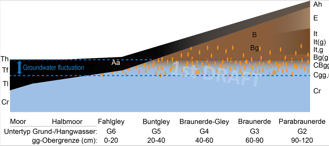
CH Groundwater classification
Key idea: Soil type depends on depth & fluctuation of groundwater
Shallow GW → strong gleying
Deeper GW → weaker redox influence
Gradient (GW depth ↓):
Moor / Halfmoor → permanent saturation (G6)
Fahlgley / Buntgley → fluctuating GW, strong redox (G5)
Braunerde–Gley → moderate gleying (G4)
Braunerde → weak/no gleying (G3)
Parabraunerde → no GW influence (G2)
We watch at current water system (could be influenced from man and not natural)
Anaerobic OM accumulation
Process: Permanent waterlogging → O₂ deficit → very slow OM decomposition
Result: Peat accumulation (organic matter dominates soil volume)
Key conditions: High groundwater, low redox, cold or wet climate
Horizons: Thick H horizons (H1–H3), mineral C often deep or absent
Chemistry: Very high Corg, high C/N, low bulk density
Plant growth / agriculture:
❌ Poor naturally (anoxia, low nutrients)
✔ Productive only after drainage → but high CO₂ loss & subsidence risk
Human influences
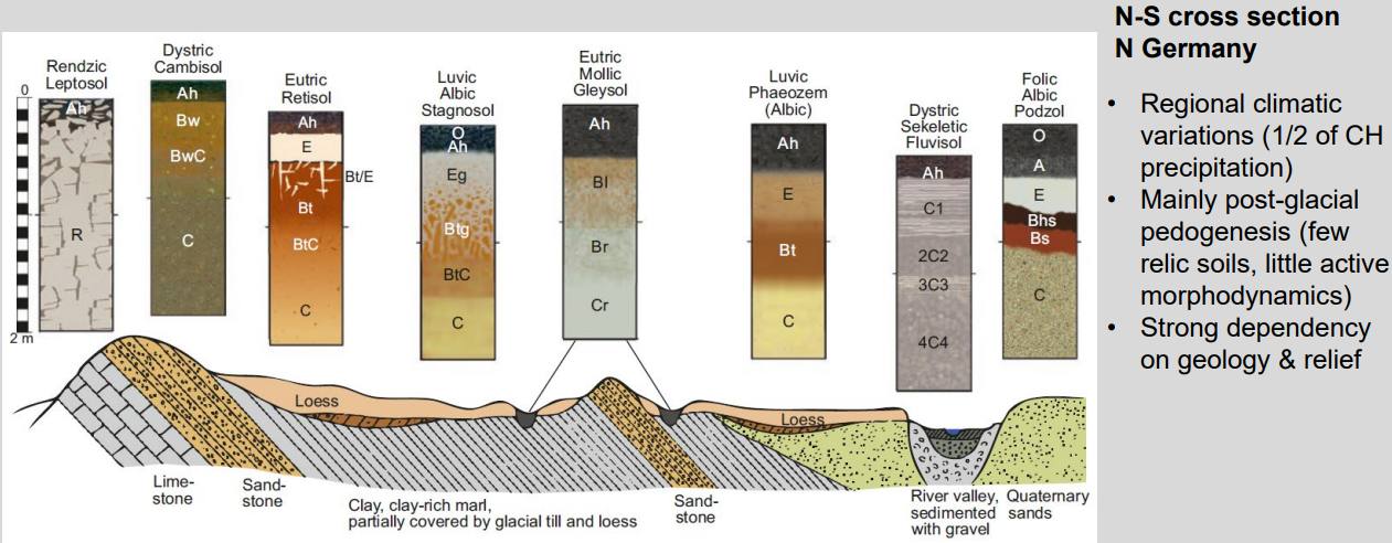
Temperate humid transect (N Germany)
Water regime: dry → periodically wet → permanently wet
Redox conditions: oxic → alternating → reducing (gley features)
Soil depth: shallow → deeper → often young/alluvial
Pedogenesis: weak weathering → clay translocation → redoximorphism
Fertility: often increases in loess positions, decreases in wet depressions
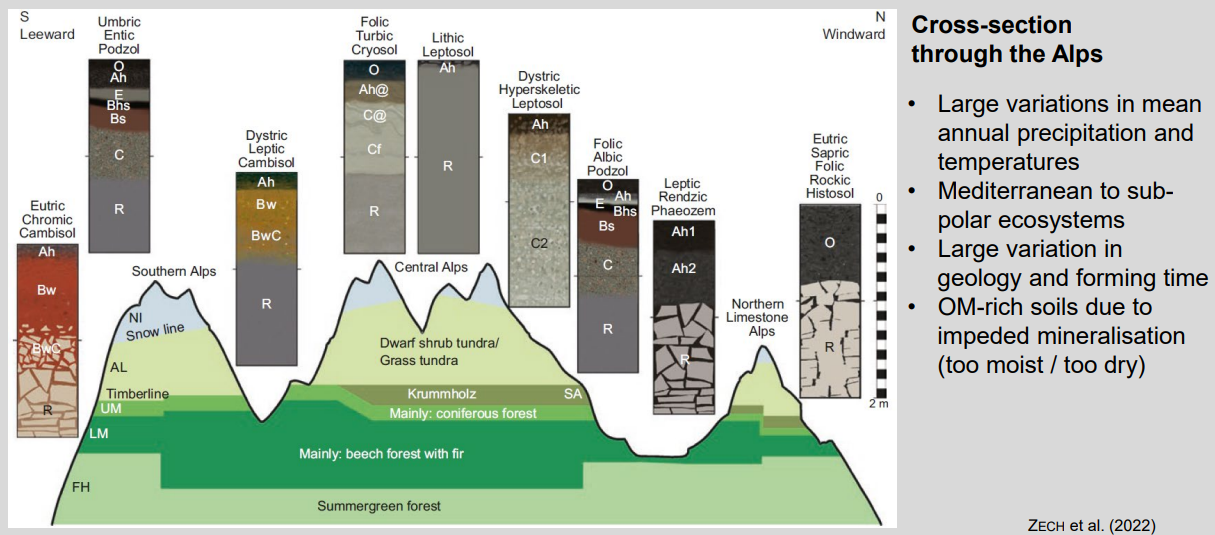
Temperate mountains transect
Climate: warm/dry → cold/wet with altitude
Vegetation: deciduous → conifer → tundra
Processes: brunification → podzolization → cryoturbation / gleying
Soils: deeper & developed → shallow, skeletal
OM: low → accumulates in cold/wet zones
Core idea: altitude and climate drive rapid soil changes along the Alps.
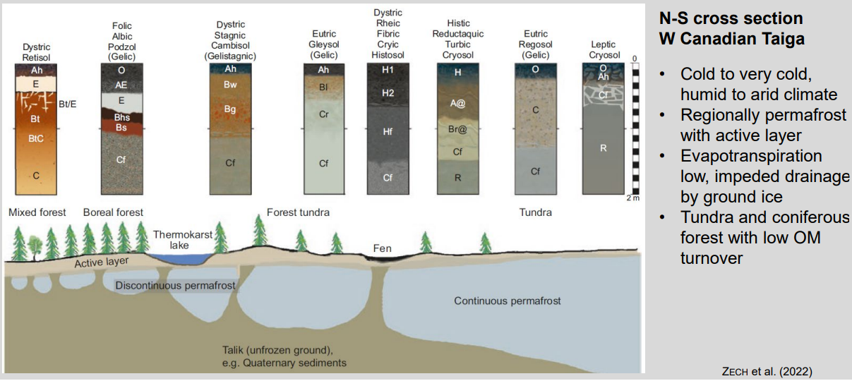
Boreal to polar region transect
Climate: cold → very cold; moisture often high, ET very low
Permafrost: absent → discontinuous → continuous (controls everything)
Hydrology: impeded drainage, waterlogging above frozen ground
Processes: podzolization → gleying → cryoturbation / peat accumulation
Soils: forest Podzols & Gleys → Histosols → Cryosols
OM: strong accumulation, very slow decomposition
Core idea: permafrost + cold climate dominate soil development along the catena.
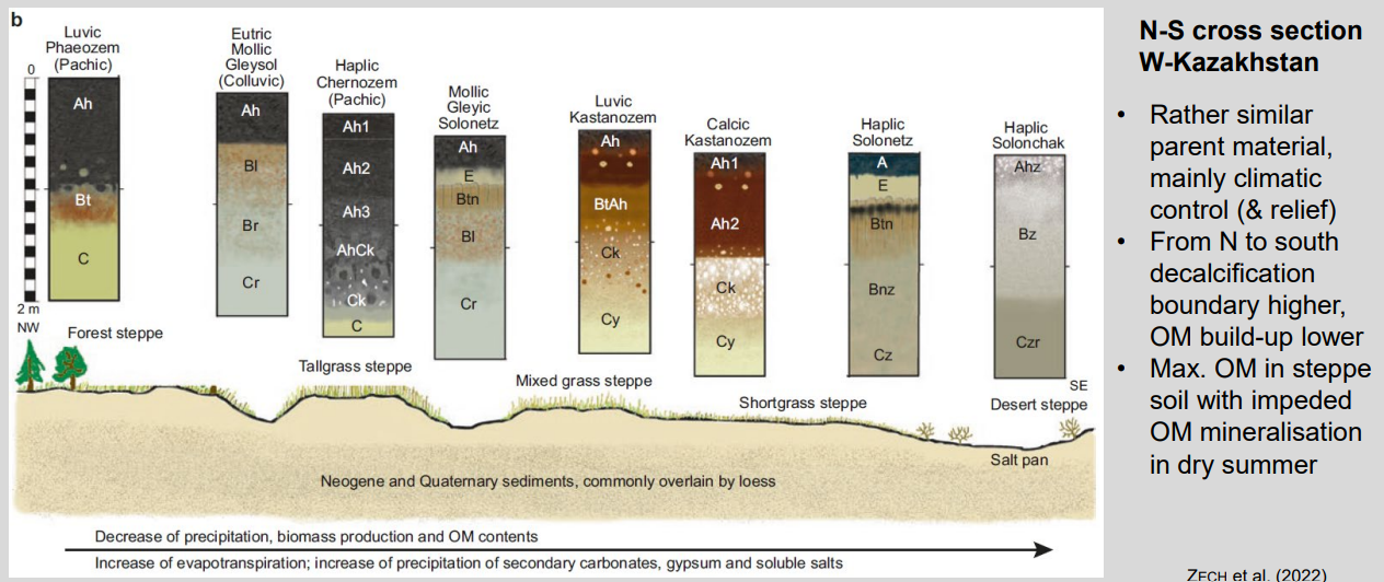
Temperate semi-humid to dry transect
Main driver: climate gradient (parent material mostly uniform)
N → S: forest-steppe → steppe → desert
Water balance: precipitation ↓, evapotranspiration ↑
Soil processes: decalcification → carbonate accumulation → salinization/sodification
OM: highest in steppe, decreases toward desert
Key idea: increasing aridity controls soil properties and horizons along the catena.
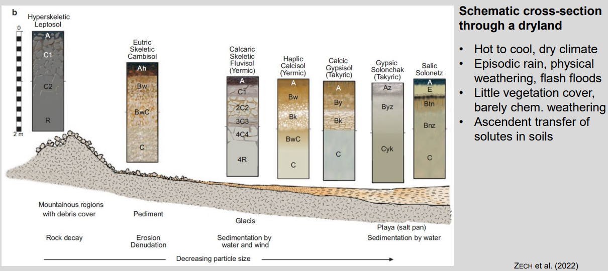
Arid region transect
Main driver: aridity + episodic rainfall
Upslope → downslope: rock weathering → erosion → sedimentation (pediment → glacis → playa)
Processes: weak chemical weathering, strong physical weathering
Water movement: upward capillary rise dominates
Soil trend: skeletal soils → calcic/gypsic soils → saline soils
Key idea: decreasing moisture and increasing evaporation control soil development and salt accumulation along the catena.
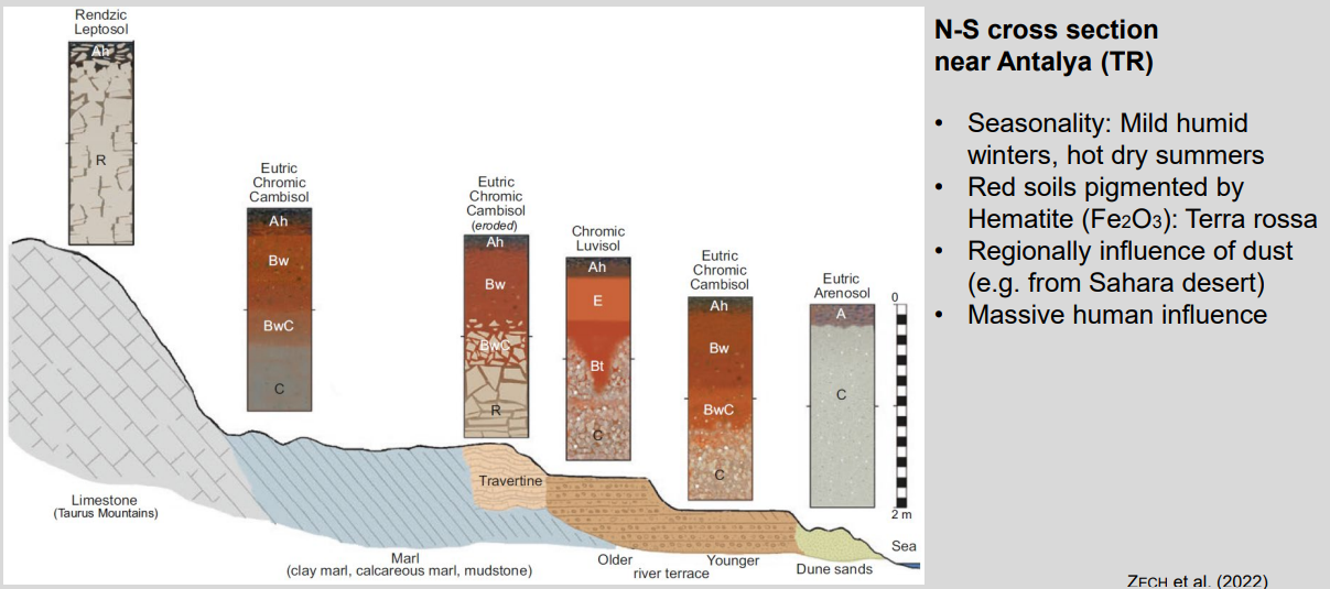
Mediterranean transect
Climate control: mild, humid winters → leaching; hot, dry summers → oxidation
Processes: decalcification + rubefaction (Fe oxidation → red colors)
Upslope → downslope: shallow calcareous soils → deeper red soils → young sandy soils
External inputs: Saharan dust contributes fine material and Fe
Human impact: strong erosion, truncation, reworking of soils
Key idea: seasonal climate + carbonate parent material produce red Mediterranean soils along the catena.
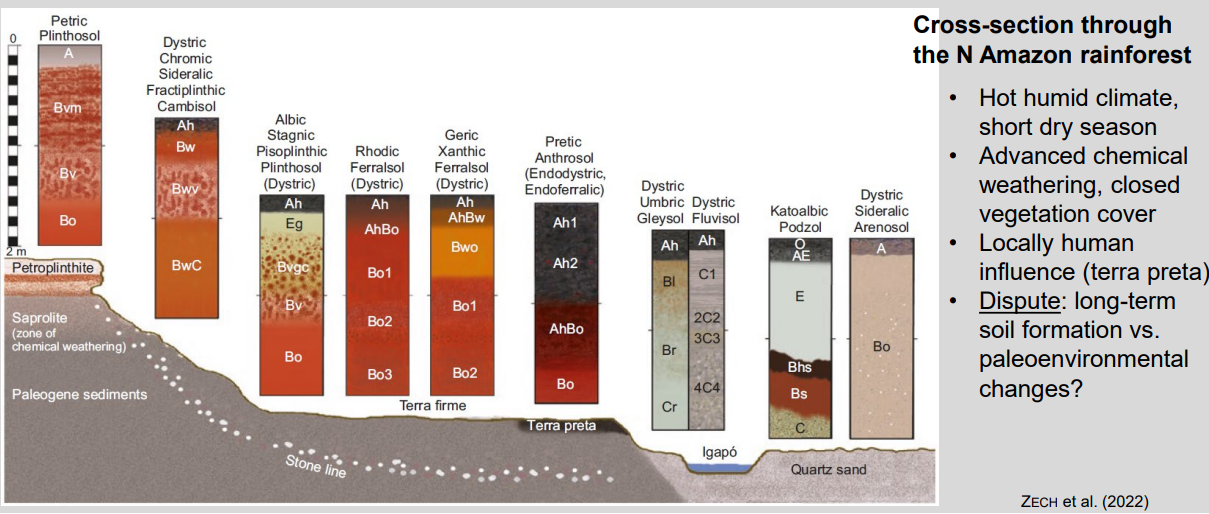
Humid tropic transect
Climate: hot, humid → extremely intense chemical weathering
Processes: strong leaching, Fe/Al oxide accumulation, deep weathering profiles
Soil trend: highly weathered upland soils (Ferralsols/Plinthosols) → hydromorphic soils in valleys
Biology: closed forest → rapid nutrient cycling, low nutrient storage in soil
Human signal: local enrichment by humans (terra preta)
Key idea: climate-driven extreme weathering dominates; nutrients are in biomass, not in the soil.
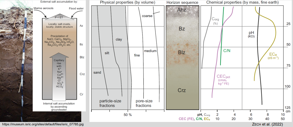
Arid regions properties and processes
Climate: low precipitation, high evapotranspiration (P < ET)
Main processes: upward water movement → capillary rise and salt accumulation
Chemistry: alkaline pH, high salinity (Na, Ca, Mg salts), weak leaching
Organic matter: very low (sparse vegetation, slow inputs)
Typical features: salt/gypsum/carbonate horizons, surface crusts
Key limitation: salinity + water stress strongly limit plant growth and agriculture
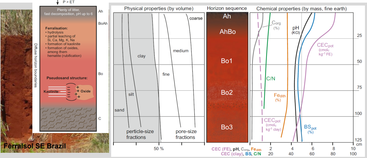
Humid tropical soils properties and processes
Climate: hot, humid, high rainfall (P > ET)
Main processes: intense chemical weathering (ferralisation), strong leaching
Mineralogy: loss of bases & silica → kaolinite + Fe/Al oxides (hematite → red color)
Chemistry: low pH, very low base saturation, low nutrient reserves
Organic matter: rapid decomposition → thin, fast-cycling OM
Agriculture: naturally low fertility, productive only with strong management (fertilization, OM inputs)
Soil classification strategies
Factor-oriented
Pedogenetic (Germany [+ geogenetic])
Morphological (USA, WRB, France) linked to genesis and/or functioning
Numerical (e.g. Hughes et al. 2014)
User-oriented (non-pedological)
From different classification types there is no direct translation, most of the time you have to rewatch all the soil data and classify again
Soil mapping philosophy
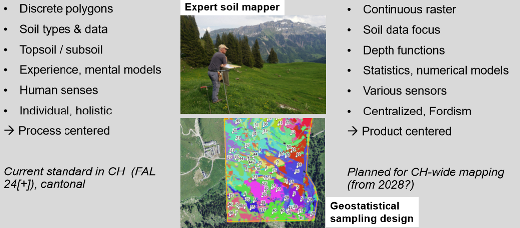
Summary
Differences between classifications
Swiss (KLABS / CH):
Process- and use-oriented
Strong focus on water regime (groundwater, stagnation), soil functions and agricultural relevance
Detailed horizon suffixes for redox, gleying, human influence
Very site-specific, well adapted to Swiss landscapes
German (KA5):
Morphogenetic approach
Emphasis on soil-forming processes (e.g. lessivation, podzolisation, gleying)
Very detailed horizon diagnostics and field morphology
Less focused on land use, more on genesis
International (WRB):
Globally comparable system
Based on diagnostic horizons, properties and materials
Strong climate signal indirectly (e.g. Podzols, Ferralsols, Cryosols)
Less local detail, not designed for land-use planning
➡ In short:
KLABS = practical & hydrology-focused
KA5 = process & morphology-focused
WRB = global & climate-sensitive comparability