APHG all vocabulary terms & examples
1/328
There's no tags or description
Looks like no tags are added yet.
Name | Mastery | Learn | Test | Matching | Spaced | Call with Kai |
|---|
No analytics yet
Send a link to your students to track their progress
329 Terms
Longitude
A numbering system using north and south parallels measuring east to west (ex: 39E, 14W)
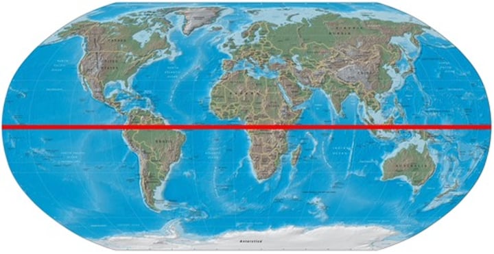
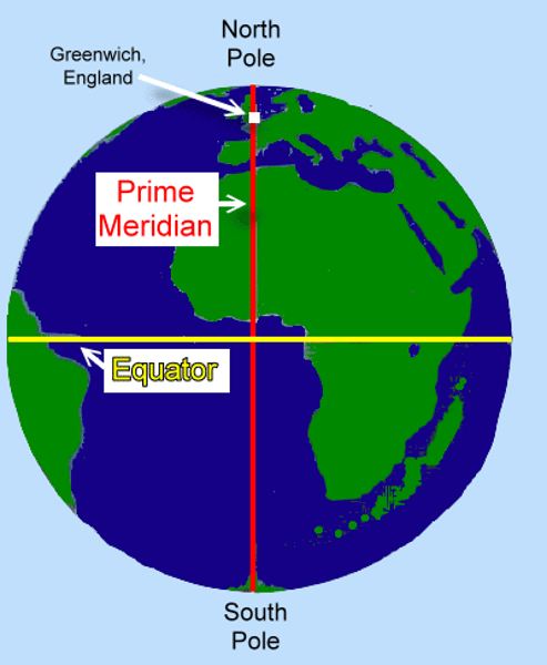
Equator
The imaginary line that goes around the center of the earth, marking 0 latitude
Arithmetic density
Total population divided by total land area (ex: 2M people/10sqmi= 200K people/sqmi)
Township & range
A rectangular land division scheme to disperse settlers evenly across farmland (ex: Land ordinance of 1785)
Relocation diffusion
The spread of ideas via the physical movement of people (ex: Spread of culture through immigration)
Absolute location
The position of a place in a way that never changes (ex: 35N, 28E)
Environmental determinism
The impact certain aspects of a place have on the population that live there (ex: chinese culture v. brazilian culture)
Time-space compression
The reduction of time it takes for something to spread, resulting from better communications and transport systems (ex: reduction of tie needed to communicate with people from distant lands)
Relative location
The location of something relative to another location (ex: FHS is 0.6 miles from Kroger)
Situation
A location relative to other locations of human activity (ex: two houses to the left)
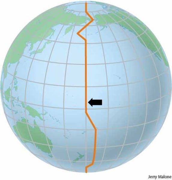
International date line
The line at 180 longitude marking the changing of the dates
Possibilism
The theory that the physical environment may set limits on human actions, but people can adjust to their environment and do an alternative action (ex: Ice rink in Saudi Arabia)
Geographic information system (GIS)
A computer system that stores, organizes, analyzes, and displays geographic data (ex: data comes from photos taken by photogrammery)
Global positioning system (GPS)
A system that determines the precise position of something on Earthś surface (ex: GPS is installed on many electronic devices and can help with geotagging)
Time zones
Areas that observe a standard time altogether (ex: EST, BST)
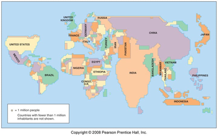
Cartogram
A map in which some factors are distorted to a ertain extent based off a certain variable
Prime meridian
0 longitude, the invisible line representing the middle of longitude
Site
The physical characteristic of a location (ex: Two shrubs, a blue door, arched window)
Density
The frequency of something in a certain area (ex: Population of US, number of trees in a redwood forest)
Linear Pattern
The arrangement of objects following a line (ex: Houses on a street)
DIstance decay
A phenomenon in which the father away two people are, the less likely they are to interact (ex immigration)
Mental map
A representation of a portion of earth's surface based off what someone knows (ex: Recalling grocery store layouts)
Random Pattern
a pattern with no specific order or logic behind its arrangement (ex: distribution of baseball teams in the US)
Statistical map
a type of map in which variation in a factor's quantity is indicated & shows a difference in values of geographical regions (ex: choropleth, dot-distribution)
Topography
The elevation and changes in elevation of a region (ex: isoline maps)
Mets & bunds system
A survey of land based off what people can see (ex: Knox county, Maine, Kentucky)
Choropleth map
A map in which different recognized areas are darker/lighter based off a certain variable
Latitude
A measuring system used to represent north and south parallels (ex: 35N, 48S)
Phsyiological density
A form of measuring population density in which total population is divided by farm land (ex: 10,000 people/4,000sqK arable land= 2.5 people/km)
Location
The position of something on earth's surface (ex: 12.345N, 67.891E)
Place
A specific point on earth distinguished by a particular characteristic (ex: new york city)
Hierarchical diffusion
Ideas that spread from authority figures to other people/places (ex: Regional offices for Honda are headed by headquarters in tokyo)
Human environment interaction
The impact humans have on their environment & how their environment affects them (ex: Global warming, diets of people in different areas)
Relative distance
the measurement of space between two places (ex: 10 minutes from school)
Natural landscape
The physical landscape or environment that has not been affected by human activities (ex: Amazon rainforest)
Isoline map
A map that connects points of equal value & shades them according to value
Thematic maps
Any map depicting a specific phenomenon of abstract objects (ex: cartogram, graduate circle map, choropleth map)
Absolute distance
A measure of distance using quantitative standard measurement such as miles or kilometers (ex: 5 miles away)
Sequent occupancy
The imprints successful populations leave on a place (ex: Influences from the inca and colonial spanish on bolivia)
Stimulus diffusion
The spread of a n underlying principle even though a characteristic fails to diffuse (ex: features on iphone, ipad, etc)
Functional/nodal region
An area focused around a node or focal point (ex: designated market areas)
Contagious diffusion
The rapid spread of a characteristic throughout the population (ex: COVID-19, memes)
Map projection
A scientific method of transferring locations on Earth's surface to a flat map (ex: Mercator, equal area)
Centralized pattern
The cluster of objects around another object (ex: Islamic circles formed around a mosque)
Map scale
A feature on a map portraying the size of the earth compared to the area displayed on a map (ex: 1/24000, 1:24000, 1 in=1 mi)
Spatial interaction
A realized flow of passengers/freight moving from the same origin to destination (ex: Migration, shopping trips)
Perceptual region
An area/location that people associate with their cultural identity (ex: The south, queens)
Formal region
An area in which one of more characteristics are shared throughout the entire region (ex: Montana)
Distribution
The arrangement of a feature in space (ex: location of towns, seating arrangements)
Remote sensing
Data about the earth's surface from a satellite from earth (ex: data on the ocean floor found using remote sensing)
Sustainability
The use of earth's resources that ensures it will be available in the future (ex: permanent grocery bags)
Scale of analysis
The area chosen for analyzing a phenomenon on a map (ex: Local analysis, regional analysis)
Gross domestic product (GDP)
The total value of goods and services produced within the borders of a country during a specific time period (ex: 1 $5 bananas + 5 $6 backrubs= $35)
Dependency theory
LDCs are depended on employment from the factories and technologies of MDCs (ex: 1650-1900 European colonization)
Consumer goods
A resource that can be bought/bartered for (ex: groceries, clothes)
Calorie consumption
The total number of calories eaten (ex: 2,000 calories/day)
Foreign direct investment
Investment made by a foreign company in the economy of another country (ex: A japanese car company plant in mexico)
Primary economic activity
An economic activity concerning mining/harvesting raw materials (ex: fishing, farming)
Tertiary economic activity
An economic activity concerning the sale/exchange of goods (ex: retail)
Secondary economic activity
An economic activity concerning the refinement of raw resources (ex: textiles, electronics)
Microloan (microfinance)
Small loans made to small businesses/individuals in developing countries with no access to commercial bank loans (ex: A farmer making loans from a rurally-based credit union)
A form of tourism, based on the enjoyment of scenic areas or natural wonders, that aims to provide an experience of nature or culture in an environmentally sustainable way (ex: Grand canyon)
Structural adjustment
A program that contains economic "reforms" or "adjustments" (ex: reducing government spending, controlled inflation)
Purchasing power parity (PPP)
An adjustment made to the GNI to account for differences among countries in the cost of goods (ex: New jersey house price= / Lesotho house price=$)
International division of labor
The transfer of jobs from MDCs to LDCs (ex: textile copanies in Bangladesh due to cheap labor)
Gross national product/income (GNP/GNI)
The total value of goods & services, including income from abroad, produced by the residents of a country within a specific time frame (ex: food, cars, healthcare, financial services)
Gender inequality index (GII)
A composite metric of gender inequality based on reproductive health, empowerment, and the labor market. The higher the number, the higher the inequality (ex: Afghanistan= 0.748/ Sweden= 0.013)
Human development index (HDI)
A system that measures the status of life based off of life expectancy, education, and income per capita. The higher the number, the higher the status of life (ex: US= 0.921; Malawi=0.51)
Quaternary economic activity
An economic activity concerning the manipulation od knowledge/information (ex: internet, programmers)
Gender development index (GDI)
A system that measures gender inequality based off health, education, and command over economic resources. The higher the difference, the higher the inequality (ex: male 0.533- female 0.273= 0.263)
Fair trade
Trade that provides equity to workers in small businesses in LDCs via reducing restrictions (ex: cocoa businesses, banana businesses)
Austerity
When a government cuts unessential spendings in order to give money to citizens (ex: reducing healthcare)
Productivity
The value of a particular product compared to the amount of labor needed to produce it (ex: a worker making $3/hr)
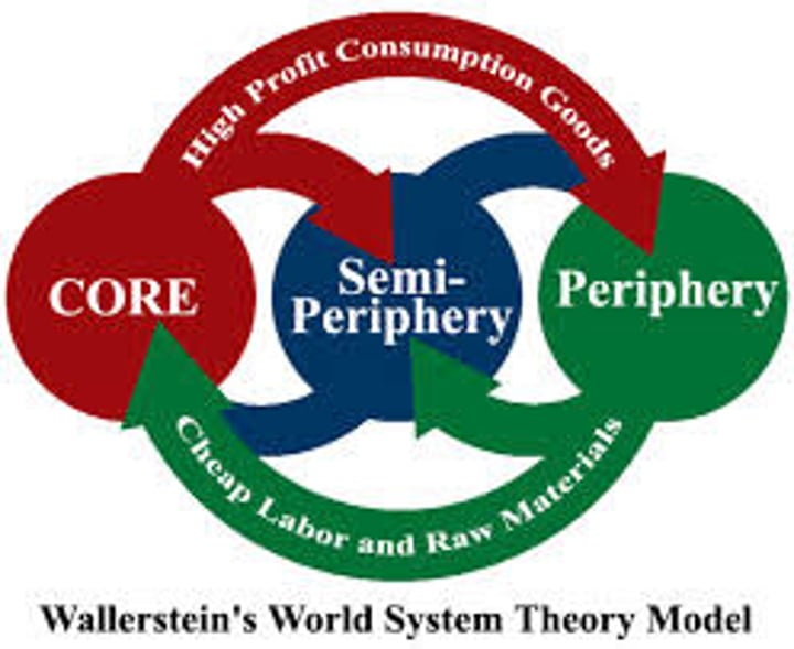
Wallerstein's world systems theory
Rich core capitalist countries succeed by exploiting poorer peripheral countries
Stimulus
The government gives people money and jobs to purchase goods (ex: the usual approach to structural adjustments today)
Rostow's stages of growth model
A hierarchical model of economic growth involving in chronological order: traditional society, preconditions to take off, take off, drive to maturity, and age of high-mass consumption (ex: brazil & mexico)
International mirgration
Migration between two countries (ex: south korea -> united states)
Activity space
The space/locations in which you pursue daily activities (ex: work, home)
Natural increase rate (NIR)
The rate in which the population grows omitting migration; calculated through CBR-CDR (ex: 80-45=35 NIR)
Sex ratio
The number of men in a population compared to the amount of women in a population (ex: 1,000 men/ 998 women)
Pandemic
The mass outbreak of a disease globally (ex: COVID)
Intraregional migration
Movement across a single region (ex: Sudan -> Chad)
One-way migration
Migrants hear of opportunity in a big city, sell everything to reach the big city, then move to find the opportunity is not available anymore & end up living in slums (ex: Kiberia)
Under population
When the population density is less than normal so it can't always support the economy (ex: Australia)
Zero population growth
When the crude birth rate is very near/ equal to the crude death rate, resulting in an NIR of 0 (ex: Germany)
Brain drain
Large-scale emigration of talented citizens of a country who leave to seek better opportunities for their talents (ex: workers from Thailand coming to US for better pay & conditions)
Voluntary migration
Migration in which the migrant chooses to move for economic reasons (ex: step migration)
Interregional migration
Migration across multiple regions (ex: Tennessee -> Minnesota)
Forced migration
Migration movement that cannot be explained by choice & is caused by a negative external force (ex: African slave trade)
Refugees
Migrants forced to migrate away from home & fears coming back due to war, famine, etc (ex: refugees of Syria during war)
Total fertility rate (TFR)
The average number of children a woman will have throughout her childbearing years (ex: USA= 2.5)
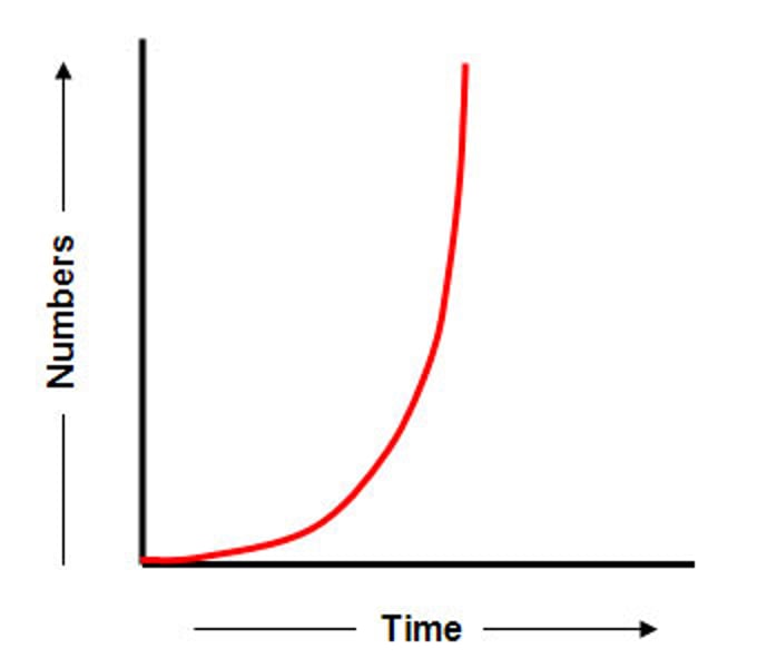
J-curve
An exponential curve that shows non-stop growth in population
Crude death rate (CDR)
The total number of deaths in a year out of every 1,000 people (ex: 386/1,000)
Crude birth rate (CBR)
The total number of live births in a year for every 1,000 people alive in the society (ex: 989/1,000)
Doubling time
The amount of 10-year increments it will take for a country to double its population (ex: s. korea doubling time= 110 years)
Natural increase rate (NIR/NRI)
The percentage in which a population grows in a year (ex: s. korea NIR= 0.068)
Population density
The number of people occupying an area of land (ex: Knoxville population= 190,740)
Infant mortality rate (IMR)
The number of babies out of 1,000 that die (ex: 212/1,1000)
Census
A complete enumeration of a population (ex: US census 2020)
Demographic region
A defined area/surface of earth you can analyze spatially (ex: Tennessee)