Paper 1 Section C: Physical landscapes in the UK
1/110
Earn XP
Description and Tags
Name | Mastery | Learn | Test | Matching | Spaced | Call with Kai |
|---|
No analytics yet
Send a link to your students to track their progress
111 Terms
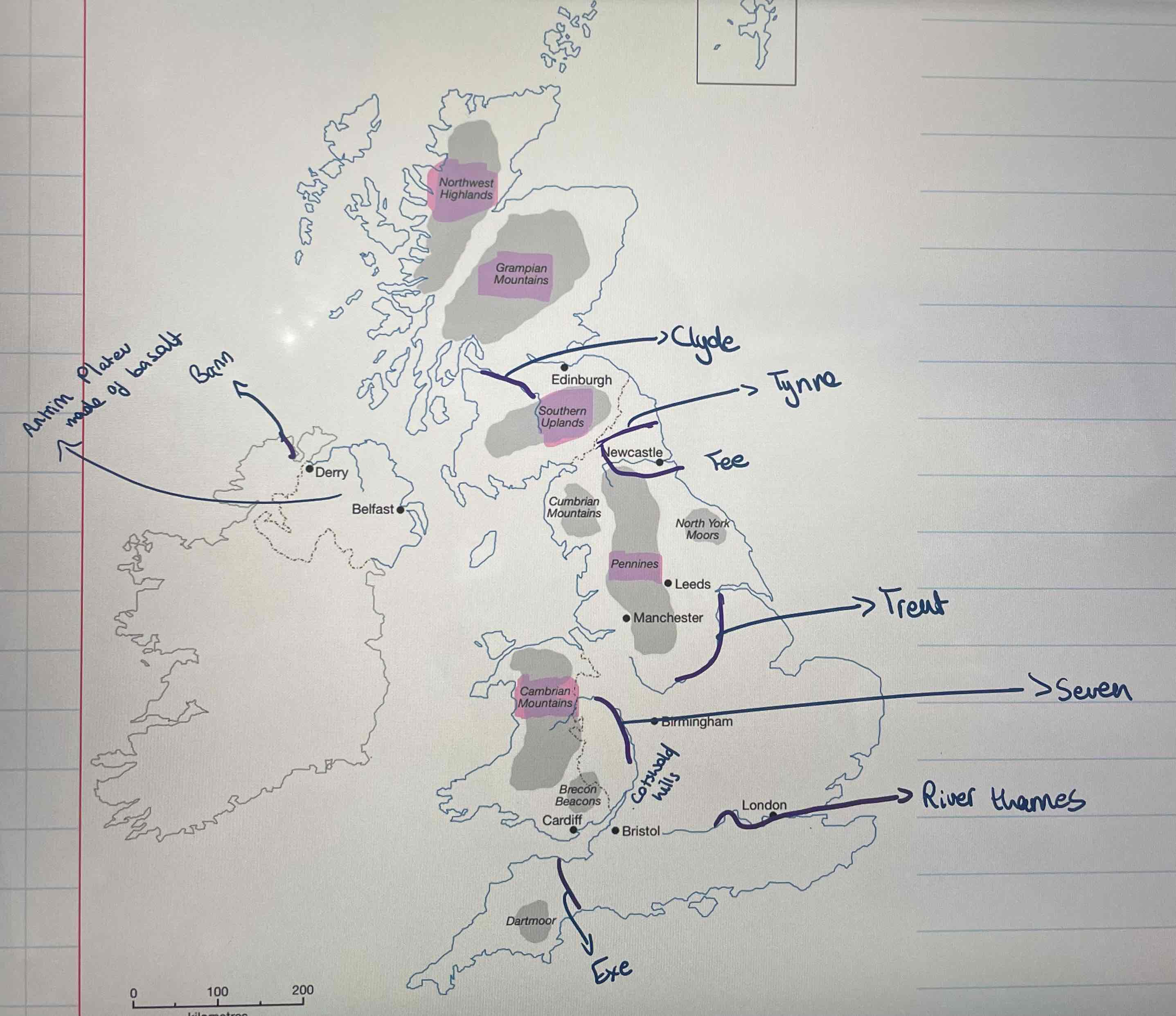
3.1 Where are the UK’s Uplands mainly located?
Mostly in the north west of the UK
3.1 Where are most of the lowland areas located in the UK?
In the south west
3.1 Give 5 main characteristics of Upland areas?
-sparsely populated
-over 600m above sea lev
-rocky
-cooler
-mountainous
3.1 Give 6 characteristics of lowland areas
-warmer
-flat
-drier
-highly populated
-less than 200m below sea level
-wider plains
3.1 Give some examples of low land areas in the uk
-Berkshire Downs
-Glen More
-The Fens
-East Anglia
3.1 Give some examples of upland areas in the uk
-Grampian Mountains
-Cambrian Mountains
-The Pennies
3.1 Give 5 facts about Upland areas?
-upland areas form about 40% of the UK land area
-they are used for farming, forestry and recreation.
-They supply much of our water and have unique plant and animal life
-they are formed from older and harder rocks (which are more resistant to erosion - mostly metamorphic or igneous rocks)
3.1 Give 4 facts about lowland areas
-about 60% of the uk’s land is lowland
-they are formed from younger, softer less resistant rocks (mostly sedimentary rocks)
-they are used for arable farming and settlements because the land is flat
-they house about 80% of the UK’s population and most major towns and cities are found here
3.1 here is a map, displaying rivers and mountains in the UK
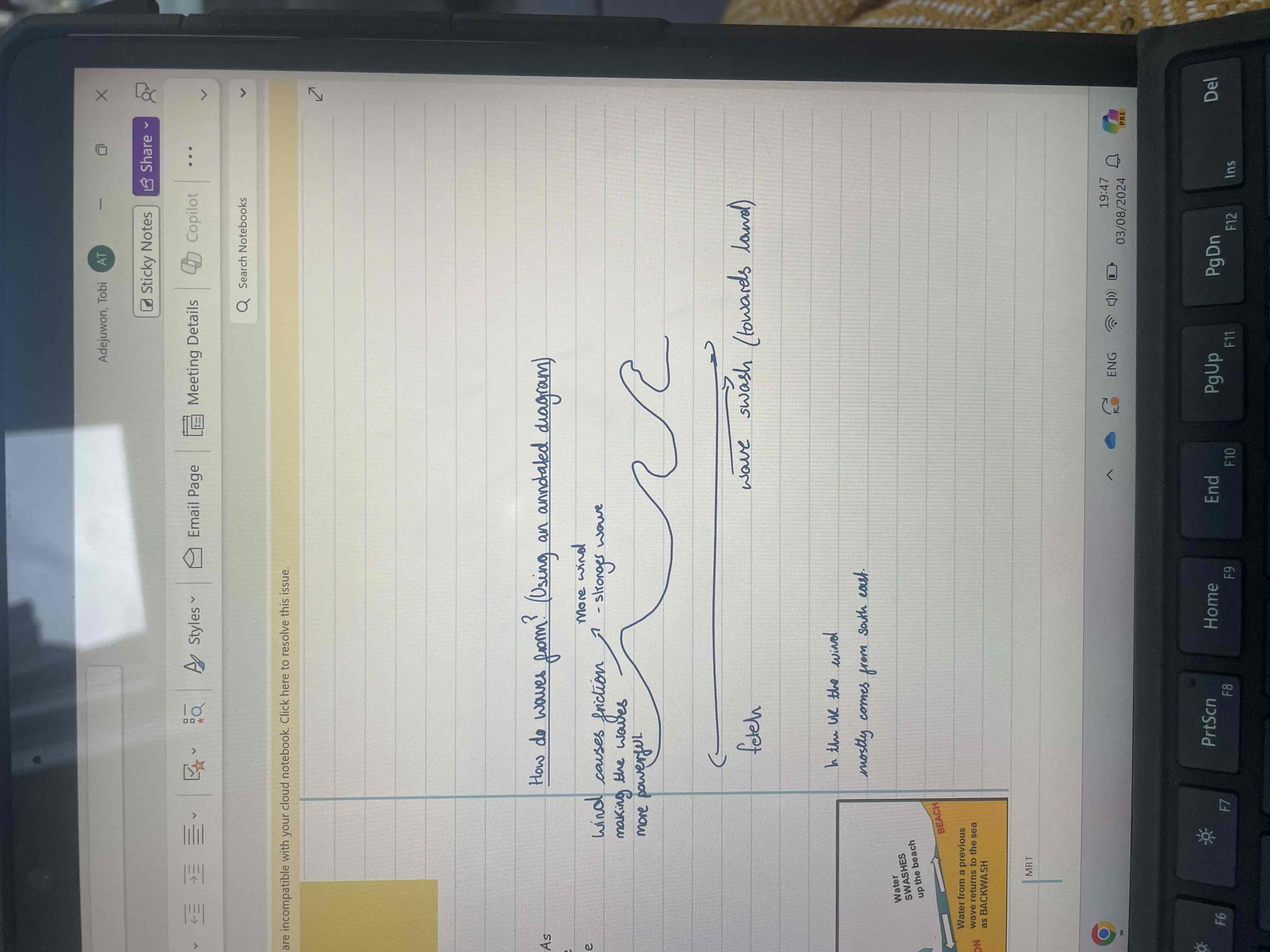
3.2 How do waves form?
Waves a created by wind blowing over the surface of the sea.
As the wind blows over the sea, friction is created - producing a swell in the water.
The energy of the wind causes water particles to rotate inside the swell and this moves the wave forward.
Waves can also be formed more dramatically when an earthquake or volcanic eruption shakes the seabed. (Tsunami)
3.2 What is the size and energy of a wave is influenced by?
-how long wind had been blowing
-the strength of the wind
-how far the wave has travelled (the fetch)
3.2 draw a diagram showing how waves form (with labels)
3.2 Give 5 Coastal processes
-weathering processes (mechanism and chemical)
-mass movement (sliding, slumping and rock falls)
-erosion (hydraulic power, abrasion and attrition)
-transportation (longshore drift)
-deposition (when sediment is deposed in coast areas)
3.2 what is the coastline?
Where land meets the sea
3.2 what is the wavelength?
The distance between crests

3.2 what is the wave period ?
The time between crests
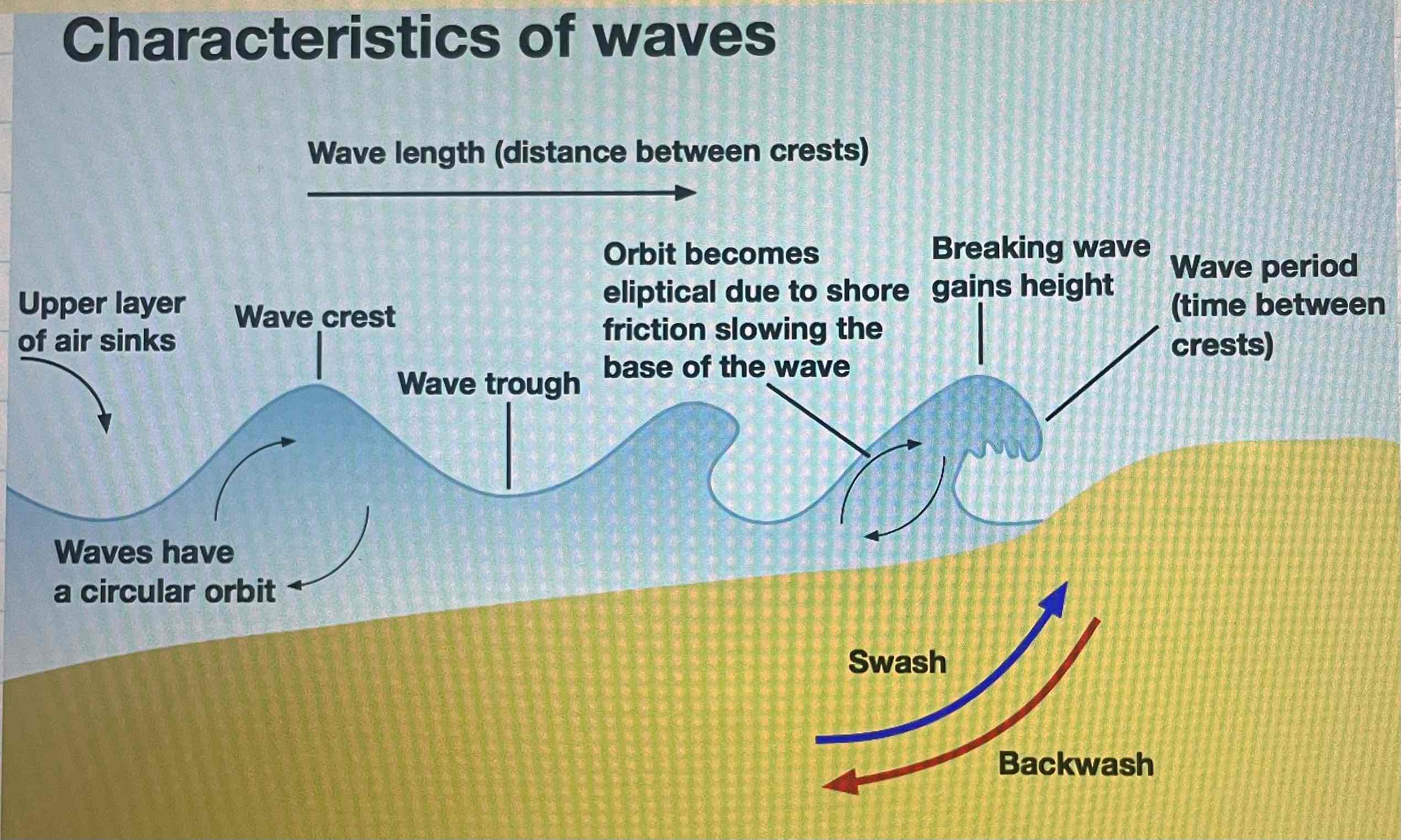
3.2 what is the prevailing wind?
The most common direction of the win
3.2 what are destructive waves?
Waves which have a strong backwash (they destroy the beach)
3.2 How can you determine the amount of erosion that can take place?
By knowing the amount of energy the wave has
3,2 Describe the features of destructive wave
-they are high energy
-more frequent than constructive waves
-they are short, steep waves that crash into the beach with force
-their backwash is stronger than their swash, so they destroy the beach
3.2 What are constructive waves?
-Waves with a strong swash and weak backwash (constructs the sea)
-These waves are formed by distant storms (often hundreds of kilometres away)
3.2 What are the characterises of constructive waves?
-they help to build up the beach
-they are long and low waves
-waves spill onto the beach with a strong swash and weak backwash
-erosion by constructive waves is limited
-they carry and deposit large amounts of sand and pebbles (build the beach)
3.2 What is weathering?
Weathering is the break down of rock in situ (where it is).
It is caused by day to day changes in the atmosphere (the weather), such as extremes of temperature and precipitation
3.2 Name the 3 types of weathering techniques
Chemical Biological, and mechanical
3.2 Explain chemical weathering
-rainwater absorbs CO2 from the air and becomes slightly acidic
-contact with alkaline rocks such as chalk and limestone which produces a chemical reaction causing rocks to slowly dissolve
3.2 Explain biological weathering
-due to action of flora and fauna, plant roots grow in rocks of rocks
-animals such as rabbits burrow into weak rocks such as sands.
3.2 Explain salt weathering
-seawater contains salt, so when water evaporates it leaves behind salt crystals
-in cracks and wholes these salt crystals grow
-putting pressure on the rocks and causing flacks to break off
3.2 What is mechanical weathering?
This is where rocks are disintegrated rather than decomposed and is usually associated with extremes of temperature
An example is freeze thraw weathering
3.2 Name the 1 method of mechanical weathering
Freeze-thaw weathering
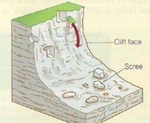
3.2 Explain freeze-thaw weathering
-water collects in rocks or holes (pores) in the rocks
-at night this water freezes and expands, making cracks in the rocks bigger
-after repeated freezing fragments of rocks may break off and fall to the feet of the cliff (scree)
3.2 Exfoliation is a type of weathering. Explain what it is
When layers of rock peel off from the surface
3.2 Which type of wave is responsible for erosion? And what are the 4 types of erosion?
-destructive waves are responsible for majority of erosion that takes place
-there are 4 types of erosion: attrition, hydraulic action, abrasion and corrosion
3.2 What are the 4 types of erosion?
-hydraulic action
-attrition
-corrosion
-abrasion
3.2 Describe abrasion
-rocks against rocks
-act like sand paper and chip rocks
-rocks get smaller and smoother
when waves pick up rocks and other material and the throw it against the coastline, causing further erosion.
3.2 Describe hydraulic action
-when waves smash against the coastline and the force of the water causes the coastline to be eroded.
3.2 Describe attrition
this is when rocks that the sea is carrying knock against each other. They break apart to become smaller and more rounded.
3.2 Describe corrosion
When acids in the sea water react with and erode rocks such as chalk or limestone.
3.2 Describe how the sea erodes the coast (3 marks)
-as the waves crash into the coat line, the force of the water causes rocks to gradually break down and break away
-the force of the water crashing against the rocks causing gabs in mountains/ cliffs, this is called hydraulic action.
-abrasion also takes place because small rocks (which have been chipped away by hydraulic action) scrap against each other (acting as sand paper), and eventually become smaller and and smoother
3.2 What is longshore drift?
the transportation of sand and pebbles along the coast
3.2 What is the prevailing wind?
the prevailing wind is the direction the wind usually blows in
3.2 Describe the process of longshore drift
1) The prevailing wind causes waves to approach the coastline at an angle.
2) The swash carries the sand and pebbles up the beach at the same angle (usually 45º).
3) The backwash carries the material back down the beach at right angles (90°).
4) The actions of the swash and backwash create a zig-zag motion along the beach.
5) Slowly the sediment moves along the beach by longshore drift and creates landforms such as spits and beaches
3.2 Using your knowledge from longshore drift, describe what would happen to a pebble that is placed in the sea?
if a pebble was placed in the water it would be carried along the coastline in a zig-zag motions (due to the swash at 45 degrees and backwash at 90 degrees) and would eventually be deposited when the waves lose energy.
3.2 What does the general direction of longshore drift depend on?
the prevailing wind.
3.2 What are the 4 costal processes of transportation?
suspension, solution, traction, saltation
3.2 Describe what suspension is
when fine and light material is carried along the river
3.2 Describe what solution is
dissolved chemicals are carried along the river in soluble rocks
3.2 Describe what traction is
when larger boulders and rocks are rolled along the river bed
3.2 Describe what saltation is
when small pebbles and stones are bounced along the river bed
3.2 Why does transportation lead to more erosion?
As the sediment is carried along the beach (through transportation) it gets smaller as attrition (a process of erosion) occurs
3.2 What is coastal deposition?
When the sea loses energy it drops the sand, rock particles and pebbles it has been carrying. This is called deposition.
Deposition happens when the swash is stronger than the backwash and is associated with constructive waves.
3.2 What conditions encourage deposition?
-when waves enter an area of shallow water
-when water enters a sheltered area (e.g a cove or bay)
-when there is little wind
-when there is a good supply of material
3.2 What is mass movement?
the downward movement or sliding of material under the influence of gravity.
3.2 What triggers mass movement?
Mostly heavy rainfall
3.2 What determines the scale of mass movement:?
the extent of weathering on that slope
3.2 What is rockfall?
When fragments of rock break away from the cliff often due to freeze thaw weathering
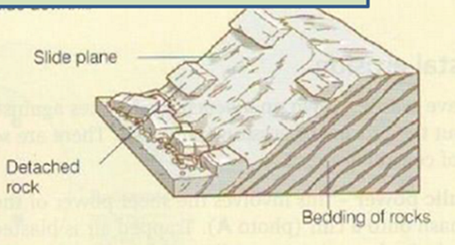
3.2 What is a landslide?
When blocks of rocks slide downhill
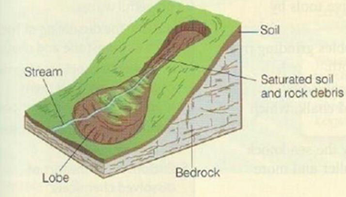
3.2 What is a mudslide?
When saturated soil and weak rock flows downslope
3.2 What is a rotational slip?
a slump of saturated soil and weak rock along a curved surface
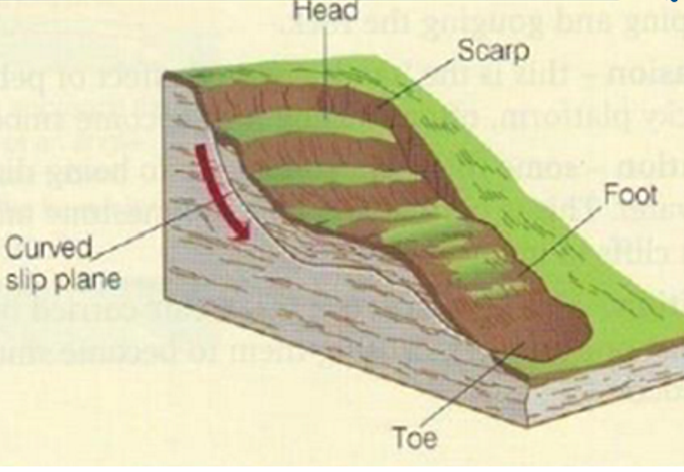
3.2 Define the term slump
A slump is a type of mass movement where a large area of land moves down a slope in one piece, leaving a curved, indented surface behind. It is also known as rotational slip.
3.2 What are falls caused by?
Slopes are steep and movement of water is rapid
Caused by a number of reasons:
Extreme weathering: Freeze-thaw action can loosen rocks that become unstable and collapse
Rainfall: Too much rain will soften the surface leading to the collapse of the slope
Earthquakes can dislodge unstable rocks
Hot weather can dry out soil causing it to shrink and allowing rocks to fall
3.2 Describe the term slide
A movement of material 'en masse' which remains together until hitting the bottom of a slope
3.2 What is geology and how does it affect the coat line?
Geology shapes the coastline vertically through the height and profile of a cliff and horizontally with bays and headlands.
3.2 What factors impact the shape and characteristics of the coast?
-a coastline made up of softer rock such as sands and clays will be easily eroded by destructive waves to form low flat landscapes such as bays and beaches
-coastlines of more resistant and hard rock will take longer to erode and produce rugged landscapes such as headlands
-so the difference between hard and soft rock will also impact the shape and characteristics of the coast.
3.2 What affect does hard rock have on a cliff at the coastline?
-Will make the shape of the cliff high and steep
-Cliff face will be bare rock and rugged
-Foot of the cliff will have boulders and rocks
3.2 What affect does soft rock have on a cliff at the coastline?
-Cliff shape: generally lower and less steep
-Cliff face: smoother; evidence of slumping
-At the foot of the cliff there will be fewer rocks; some sand and mud
3.2 Where are headlands and bays formed (mostly)?
In areas where there are alternative bands of soft and hard rock which meet at right-angles to the coast (discordant).
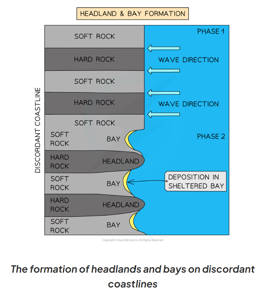
3.2 How are bays formed?
The softer rock (for examples clay) will erode more quickly forming a bay which makes sandy beaches. The erosion occurs due to a number of different processes caused by the sea; hydraulic action, abrasion, attrition and corrosion
3.2 How are headlands formed?
The harder rock (for example chalk) will erode more slowly forming headlands which jut into the sea. The erosion occurs due to a number of different processes caused by the sea: hydraulic action, abrasion, attrition and corrosion
3.2 What is a wave-cut platform?
It is a wide gentle sloped surface found at the root of the cliff
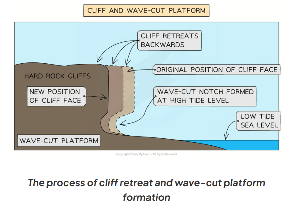
3.2 How are wave-cut platforms are formed?
-As the sea attacks the base of the cliff between the high and low water mark, a wave-cut notch is formed.
-Erosion (abrasion, hydraulic action, attrition and corrosion) extend the notch back into the cliff
-The undercutting of the cliff leads to instability and collapse of the cliff
-The backwash of the wavs, carries away the eroded material , leaving behind a wave cut platform.
-This process repeats and the coast continues to retreat, leading to a coastal retreat

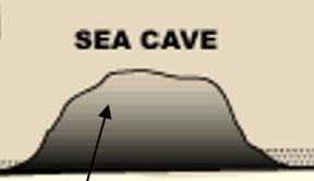
3.2 Where do caves, arches and stacks form?
They form in a headland because of wave action and sub-aerial weathering (weathering by rain, frost, rivers etc)
3.2 How do caves, arches, stacks and stumps initially form?
Due to cracks in the cliff as a result of constant erosion by waves through the processes of hydraulic action, abrasion, attrition and corrasion.
Vertical lines of weakness form a cave. Overtime the joints and faults become eroded and cracks appear.
3.2 How do caves form?
As the cracks in the cliff are eroded further, a cave is formed
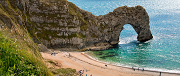
3.2 How do arches form?
If the cave is eroded right through the headland, an arch is formed
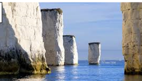
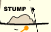
3.2 How are stacks formed?
The arch will eventually collapse as it is widened by the sea and worn by the weather leaving a stack
3.2 How is a slump formed?
The weather and sea attack to stack until ta stump is formed, often covered by water at high tide
3.2 What conditions are needed for depositional landforms to form?
Low levels of kinetic energy
3.2 What is longshore drift?
The movement of sediment along the beach.
-swashes at 45 degrees (which build up the beach)and backwashes at 90 degrees (which destroy the beach)
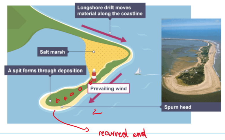
3.2 What is a spit?
A pit is an extended stretch of beach material that projects out of the sea and is joined to the mainland at one end.

3.2 how are spits formed?
-longshore drift moves material along the coastline in the direction of the prevailing wind. The angled swash brings material onshore, while the backwash moves the material down the beach under gravity.
-this continues in a zig-zag motion along the coast
-if the coast changes direction the material will continue to be deposited in the same direction in a shallow sea.
-this build up of material is called a spit
-overtime the spit grows and develops a recurved end if the wind direction changes further out.
-salt marches are formed from behind the spit where energy levels are low and it is sheltered.
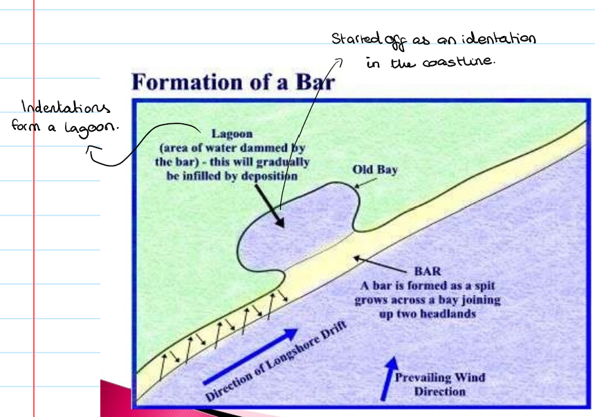
3.2 What is bar?
A bar is a narrow strip of sediment in the coastline
-bars occur when a spirt growths across a bay, and joins two headlands together
3.2 How are bars formed?
-longshore drift move material along the coastline in the direction of the prevailing wind. The angled swash bring the material onshore, while the backwash move the material back down the beach under gravity
-This continues in a zig-zag motion along the coast.
-Where there is an indentation in the coastline, material will continue to be deposited in the original direction across the indentation
-This build up of material is called a bar
-Overtime, a lagoon is formed behind the bar as it fills with freshwater
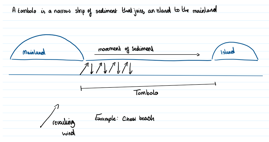
3.2 What is a tombolo?
A narrow strip of sediment that joins an island to the mainland
3.2 How are tombolos formed?
-longshore drift moves material along the coastline in the direction of the prevailing wind. The angled swash brings material onshore, while the backwash moves the material down the beach under gravity.
-This continues in a zig-zag motion along the coast
-Where there is an island lying off the mainland, material will continue to be deposited in the original direction in a shallow sea
-This build up of material that joins the mainland to the island is called a tombolo.
3.2 What is a beach?
A beach is a deposit of sand and shingle (pebbles) at the coast.
3.2 Where do beaches form?
In sheltered areas such as bays through deposition via constructive waves; When the swash is stronger than the backwash deposition occurs. Constructive waves pick up and carry sediment to form beaches.
3.2 what are sand dunes?
Sand dunes are common features of low-lying stretches of coastline.
3.2 Where do sand dunes often form?
They form in places where there is plentiful supply of sand, a broad beach that dries out in low tide and a dominant onshore wind direction.
-they provide a variety of unique habitats for living organisms
3.2 How do embryo dunes form?
Embryo dunes form around deposited obstacles such as pieces of rock or wood.
3.2 How are fore dunes formed?
Embryo dunes develop and become stabilised by vegetation to form fore dunes and tall yellow dunes.
3.2 What is marram grass?
Marram grass are adapted to windy conditions and have long roots to find water.
These roots help bind sand together and establish the dunes.
3.2 Describe the location of the Jurassic Coast
The Dorset coast is located on the South Coast of England. It stretches from Exmouth in the West to Bournemouth in the East
3.2 What is a concordant coastline?
alternative layers of hard and soft rock running parallel to the coast
3.2 What is a discordant coastline?
alternative layer of hard and soft rock running at right angles to the shore (from headlands and bays)
3.2 What are the coastal landforms at Jurassic coast?
Durdle Door: an arch - erosion by waves opened a crack in limestone headland, which became a cave and then developed into an arch
Lulworth Cave: a small bay which formed after a gap was eroded in a band of limestone