ASA PPL Test Prep Ch 7: Enroute Flight and Navigation
1/64
There's no tags or description
Looks like no tags are added yet.
Name | Mastery | Learn | Test | Matching | Spaced | Call with Kai |
|---|
No analytics yet
Send a link to your students to track their progress
65 Terms
On a cross-country flight, point A is crossed at 1500 hours and the plan is to reach point B at 1530 hours. Use the following information to determine the indicated airspeed required to reach point B on schedule.
Distance between A and B 70 NM
Forecast wind 310° at 15 kts
Pressure altitude 8,000 ft
Ambient temperature -10 °C
True course 270°
The required indicated airspeed would be approximately
137 knots.
2 multiple choice options
Why should you file a VFR flight plan with the FAA?
To provide search and rescue in the event of an emergency.
2 multiple choice options
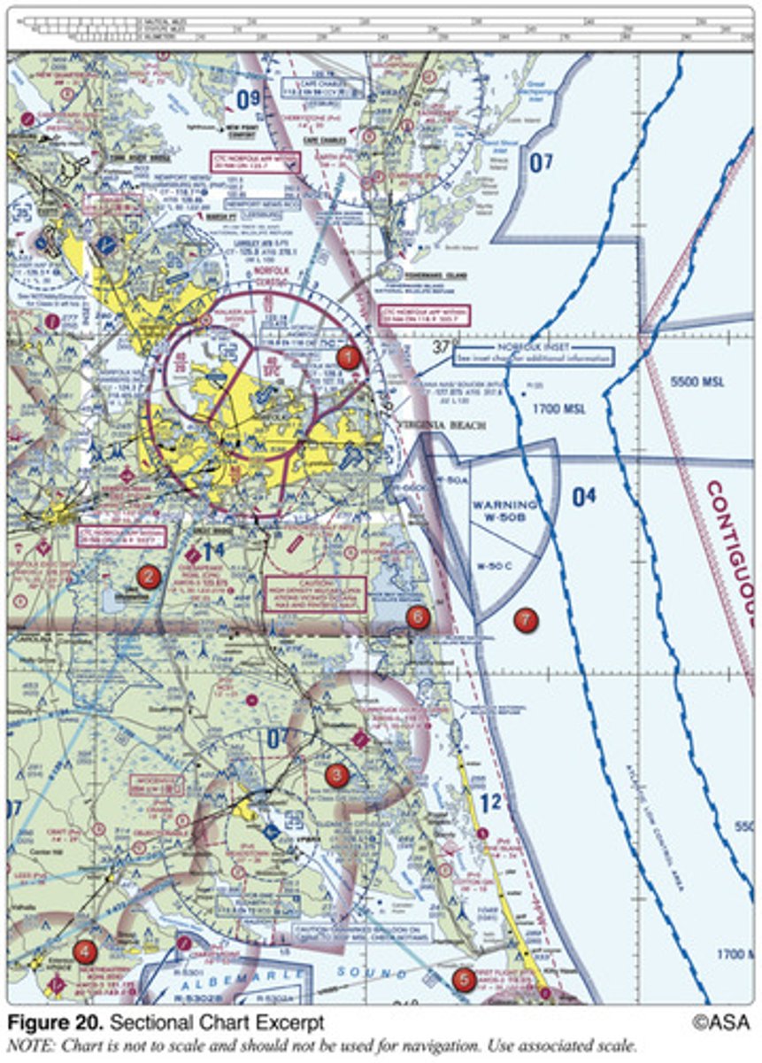
(Refer to Figure 20, area 2.) The flag symbol at Lake Drummond represents a
visual checkpoint used to identify position for initial callup to Norfolk Approach Control.
2 multiple choice options

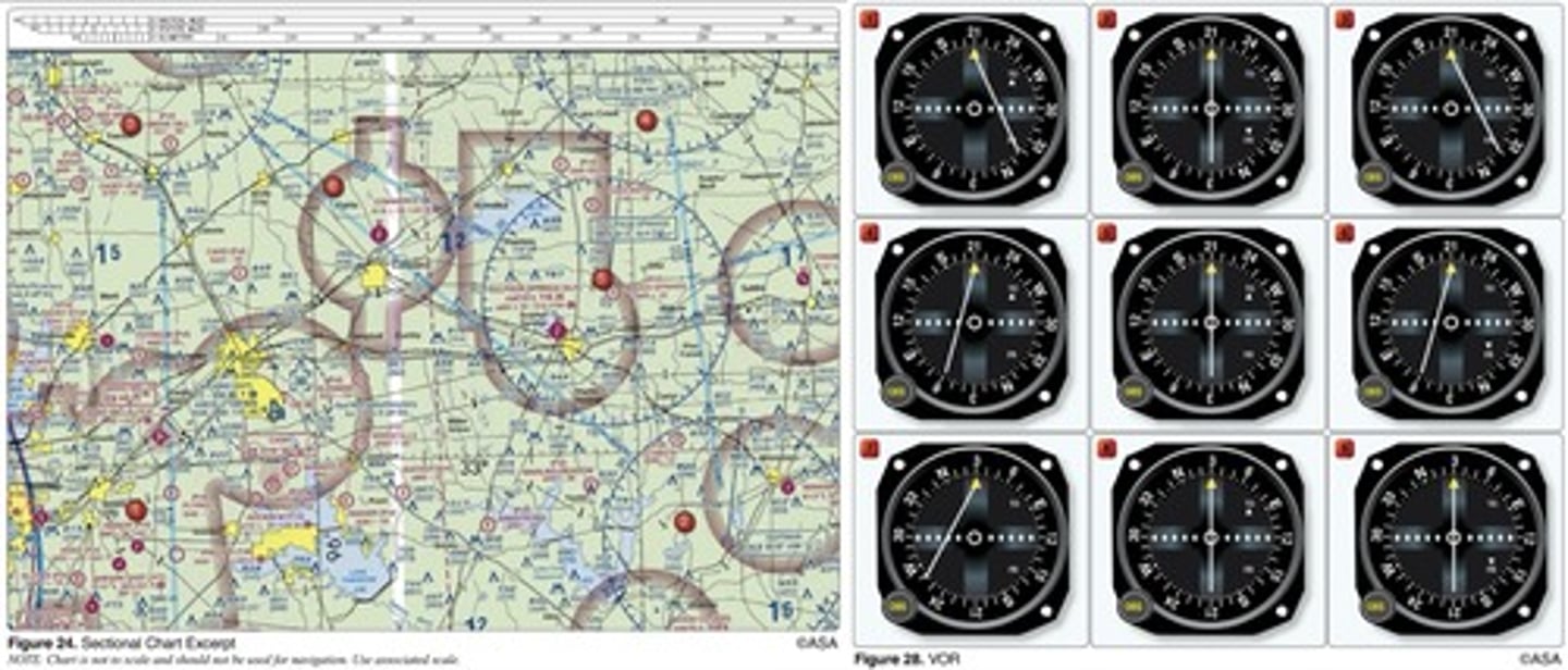
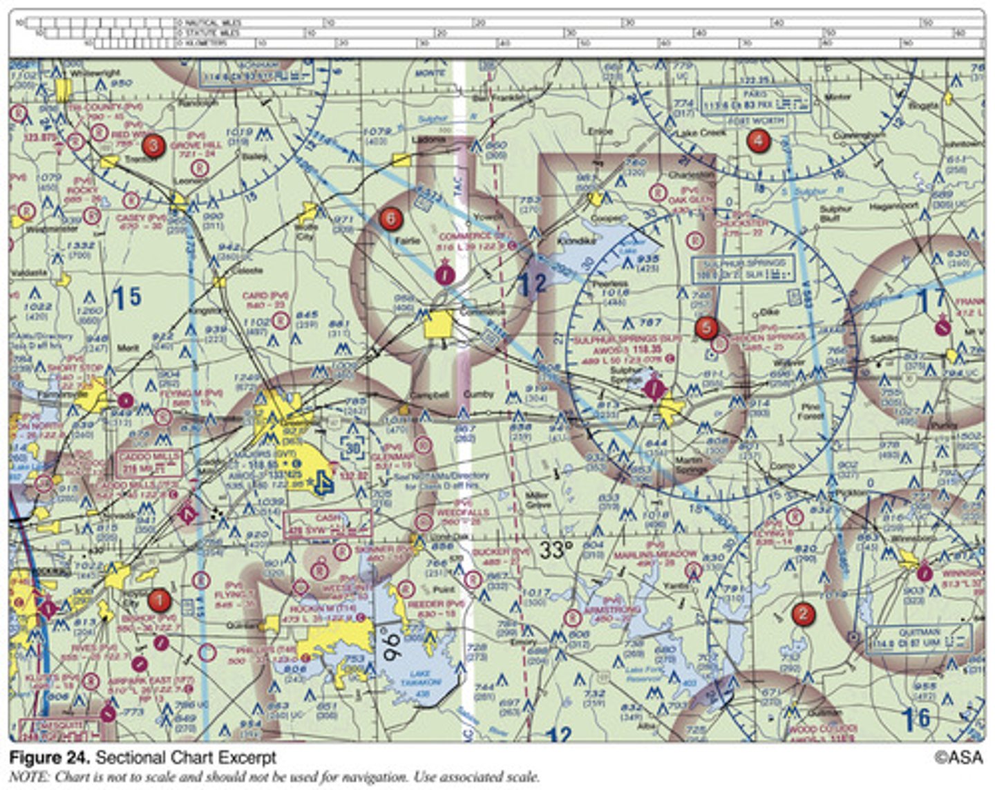
(Refer to Figure 24, area 1.) What minimum altitude is necessary to vertically clear the obstacle on the northeast side of Airpark East Airport by 500 feet?
1,273 feet MSL.
2 multiple choice options

(Refer to Figure 22.) Determine the magnetic heading for a flight from Sandpoint Airport (area 1) to St. Maries Airport (area 4). The wind is from 215° at 25 knots and the true airspeed is 125 knots.
172°.
2 multiple choice options

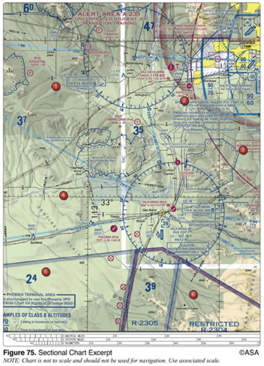
(Refer to Figure 75.) What is the time en route from the Gila Bend VORTAC to Buckeye VOR along V461 at a TAS of 125 knots and forecasted winds from 180 at 17 knots?
Approximately 13 minutes.
2 multiple choice options
If a true heading of 135° results in a ground track of 130° and a true airspeed of 135 knots results in a groundspeed of 140 knots, the wind would be from
246° and 13 knots.
2 multiple choice options
(Refer to Figure 21.) What course should be selected on the omnibearing selector (OBS) to make a direct flight from Mercer County Regional Airport (area 3) to the Minot VORTAC (area 1) with a TO indication?
359°.
2 multiple choice options

(Refer to Figure 22.) What is the magnetic heading for a flight from Priest River Airport (area 1) to Shoshone County Airport (area 3)?
The wind is from 030° at 12 knots and the true airspeed is 95 knots.
121°.
2 multiple choice options

If receiver autonomous integrity monitoring (RAIM) capability is lost in flight,
the pilot has no assurance of the accuracy of the GPS position.
2 multiple choice options
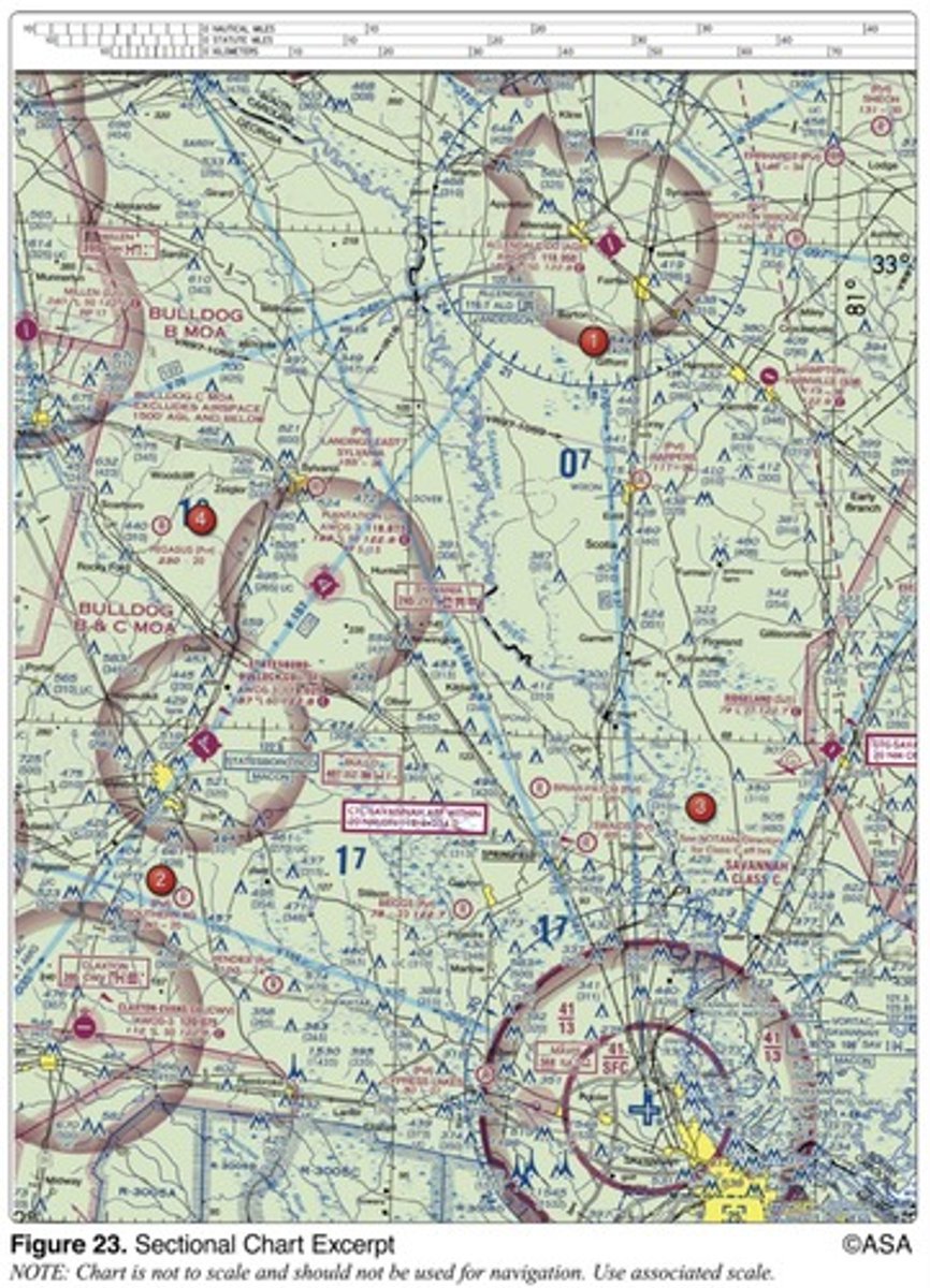
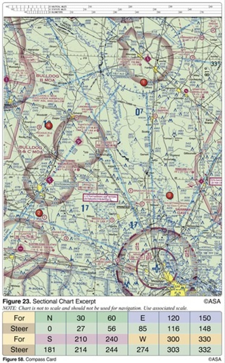
(Refer to Figure 23.) Determine the magnetic heading for a flight from Allendale County Airport (area 1) to Claxton-Evans County Airport (area 2). The wind is from 090° at 16 knots, the true airspeed is 90 knots, and the magnetic variation is 6 degrees West.
209°.
2 multiple choice options
How far will an aircraft travel in 7.5 minutes with a ground speed of 114 knots?
14.25 NM.
2 multiple choice options
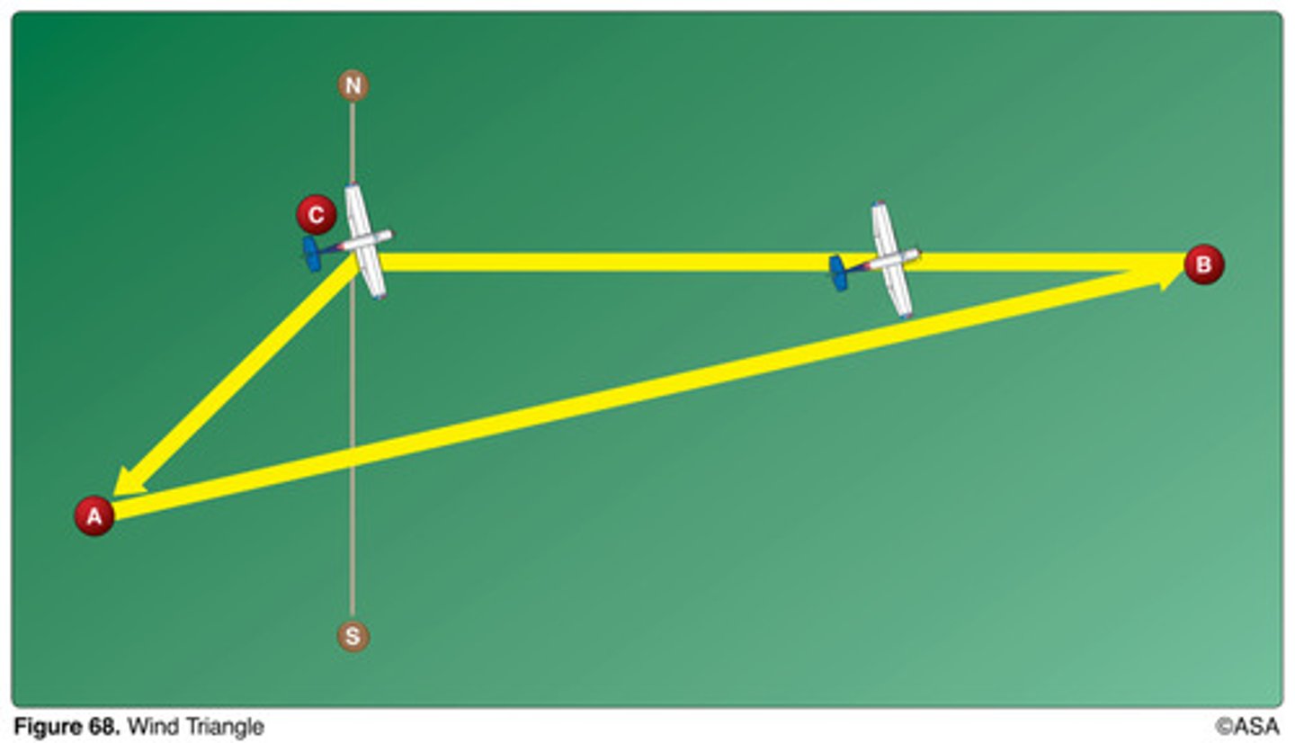
(Refer to Figure 68.) The line from point C to point A of the wind triangle represents
wind direction and velocity.
2 multiple choice options

(Refer to Figure 20, area 3.) Determine the approximate latitude and longitude of Currituck County Airport.
36°24'N - 76°01'W.
2 multiple choice options

(Refer to Figure 21.) The terrain elevation of the light tan area between Minot (area 1) and Audubon Lake (area 2) varies from
2,000 feet to 2,500 feet MSL.
2 multiple choice options

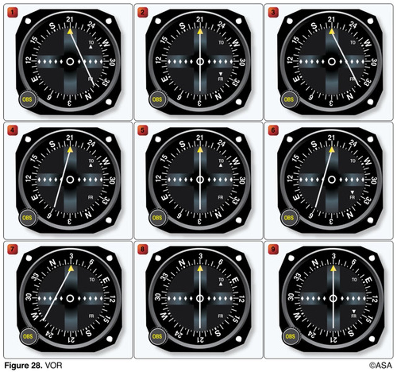
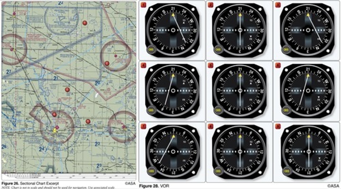
(Refer to Figure 28, illustration 5.) The VOR receiver has the indications shown. What radial is the aircraft crossing?
030°.
2 multiple choice options
(Refer to Figure 27.) An aircraft departs an airport in the central standard time zone at 0930 CST for a 2-hour flight to an airport located in the mountain standard time zone. The landing should be at what time?
1030 MST.
2 multiple choice options

(Refer to Figure 24, and Figure 28.) The VOR is tuned to Bonham VORTAC (area 3), and the aircraft is positioned over the town of Sulphur Springs (area 5). Which VOR indication is correct?
7.
2 multiple choice options
(Refer to Figure 20, area 5.) The CAUTION box denotes what hazard to aircraft?
Unmarked balloon on cable to 3,008 feet MSL.
2 multiple choice options

(Refer to Figures 23 and 58.) Determine the compass heading for a flight from Claxton-Evans County Airport (area 2) to Hampton Varnville Airport (area 1). The wind is from 280° at 08 knots, the true airspeed is 85 knots, and the magnetic variation is 5 degrees West.
042°.
2 multiple choice options
How far will an aircraft travel in 2-1/2 minutes with a groundspeed of 98 knots?
4.08 NM.
2 multiple choice options
(Refer to Figure 23, area 3.) What is the height of the lighted obstacle approximately 6 nautical miles southwest of Savannah International?
1,548 feet MSL.
2 multiple choice options

(Refer to Figure 24, area 2.) What minimum altitude is necessary to vertically clear the obstacle on the southeast side of Winnsboro Airport by 500 feet?
1,403 feet MSL.
2 multiple choice options

(Refer to Figure 27.) An aircraft departs an airport in the central standard time zone at 0845 CST for a 2-hour flight to an airport located in the mountain standard time zone. The landing should be at what coordinated universal time?
1645Z.
2 multiple choice options

(Refer to Figure 27.) An aircraft departs an airport in the Pacific standard time zone at 1030 PST for a 4-hour flight to an airport located in the central standard time zone. The landing should be at what coordinated universal time?
2230Z.
2 multiple choice options

(Refer to Figure 24.) What is the approximate position of the aircraft if the VOR receivers indicate the 245? radial of Sulphur Springs VOR/DME (area 5) and the 140? radial of Bonham VORTAC (area 3)?
Glenmar Airport.
2 multiple choice options
(Refer to Figure 68.) The line from point C to point B of the wind triangle represents
groundspeed and true course.
2 multiple choice options
(Refer to Figure 27.) An aircraft departs an airport in the mountain standard time zone at 1515 MST for a 2-hour 30-minute flight to an airport located in the Pacific standard time zone. What is the estimated time of arrival at the destination airport?
1645 PST.
2 multiple choice options

(Refer to Figure 23.) What is the approximate position of the aircraft if the VOR receivers indicate the 320° radial of Savannah VORTAC (area 3) and the 184° radial of Allendale VOR (area 1)?
Southeast of Guyton.
2 multiple choice options
Which is true concerning the blue and magenta colors used to depict airports on Sectional Aeronautical Charts?
Airports with control towers underlying Class B, C, D, and E airspace are shown in blue.
2 multiple choice options
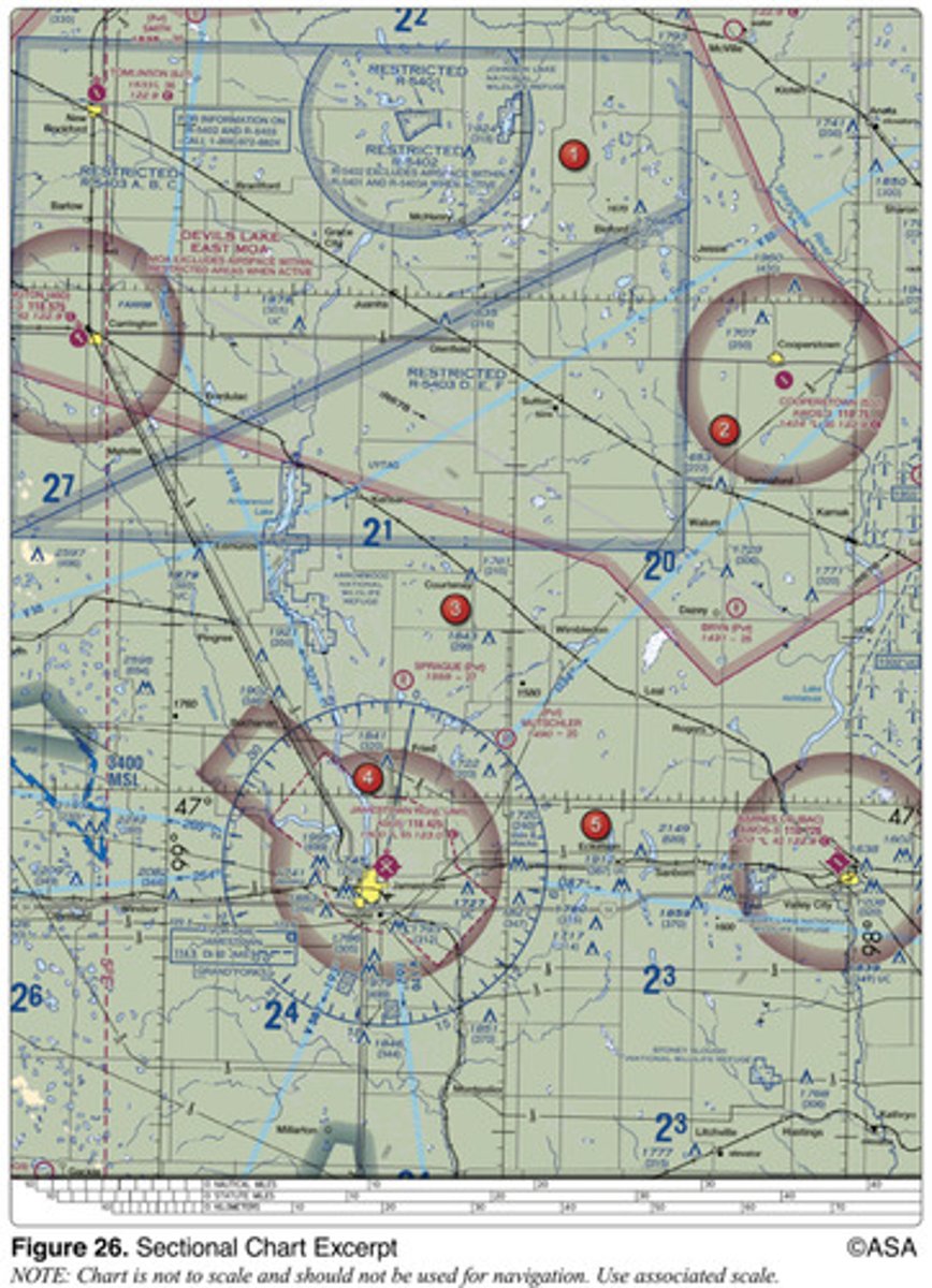
(Refer to Figure 26, areas 4 and 2; and Figure 28.) The VOR is tuned to Jamestown VOR, and the aircraft is positioned over Cooperstown Airport. Which VOR indication is correct?
5.
2 multiple choice options
(Refer to Figure 27.) An aircraft departs an airport in the eastern daylight time zone at 0945 EDT for a 2-hour flight to an airport located in the central daylight time zone. The landing should be at what coordinated universal time?
1545Z.
2 multiple choice options

(Refer to Figure 21, area 2.) Which airport is located at approximately 47°35'30"N latitude and 100°43'00"W longitude?
MAKEEFF.
2 multiple choice options

(Refer to Figure 28, illustration 4.) The VOR receiver has the indications shown. What is the aircraft's position relative to the station?
North.
2 multiple choice options

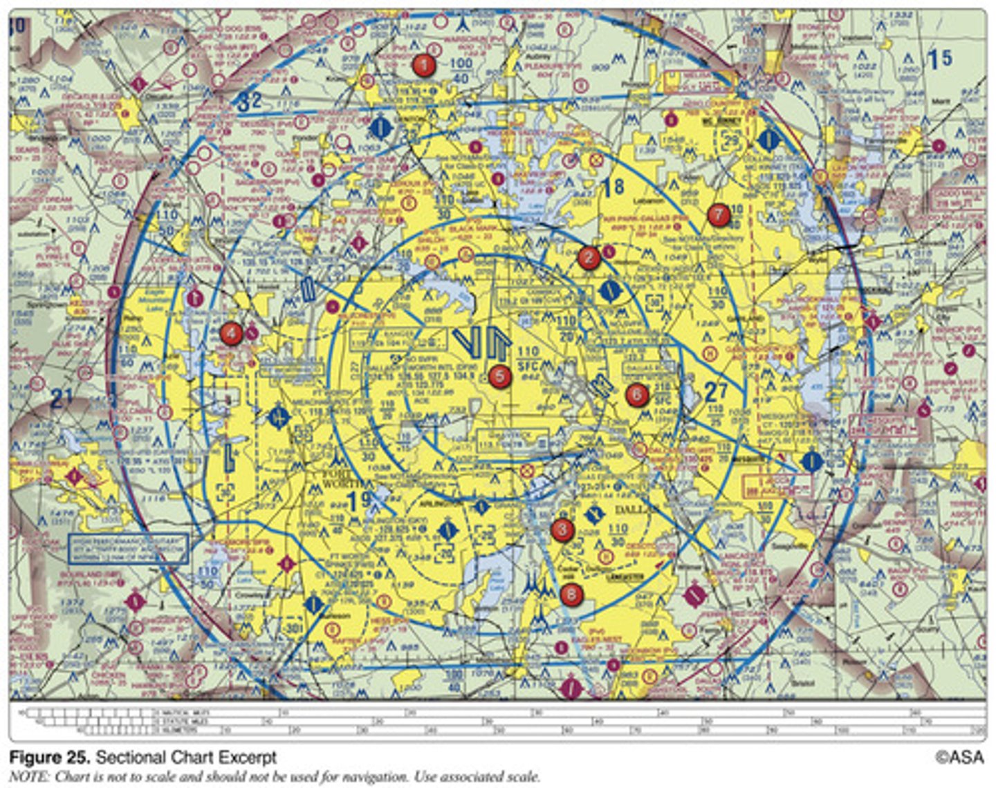
(Refer to Figure 25, area 5.) The navigation facility at Dallas-Ft. Worth International (DFW) is a
VOR/DME.
2 multiple choice options

(Refer to Figure 25.) Determine the magnetic heading for a flight from Dallas Executive (area 3) to Fort Worth Meacham (area 4). The wind is from 030° at 10 knots, the true airspeed is 135 knots, and the magnetic variation is 7° east.
286°.
2 multiple choice options
(Refer to Figure 20, area 2.) The elevation of the Chesapeake Regional Airport is
19 feet.
2 multiple choice options
How many Global Positioning System (GPS) satellites are required to yield a three dimensional position (latitude, longitude, and altitude) and time solution?
4.
2 multiple choice options
(Refer to Figure 20, area 3; and Figure 28.) The VOR is tuned to Elizabeth City VOR/DME, and the aircraft is positioned over Shawboro, a small town 3 NM west of Currituck County Regional (ONX). Which VOR indication is correct?
5.
2 multiple choice options

(Refer to Figure 25, area 8.) What minimum altitude is required to fly over the Cedar Hill TV towers in the congested area south of Dallas Executive (RBD)?
3,549 feet MSL.
2 multiple choice options

What procedure is recommended when climbing or descending VFR on an airway?
Execute gentle banks, left and right for continuous visual scanning of the airspace.
2 multiple choice options
(Refer to Figure 23, area 3.) The top of the group obstruction approximately 11 nautical miles from the Savannah VORTAC on the 009° radial is
454 feet MSL.
2 multiple choice options

(Refer to Figure 23.) On what course should the VOR receiver (OBS) be set to navigate direct from Hampton Varnville Airport (area 1) to Savannah VORTAC (area 3)?
195°.
2 multiple choice options

(Refer to Figure 27.) An aircraft departs an airport in the mountain standard time zone at 1615 MST for a 2-hour 15-minute flight to an airport located in the Pacific standard time zone. The estimated time of arrival at the destination airport should be
1730 PST.
2 multiple choice options

Which statement about longitude and latitude is true?
Lines of longitude cross the equator at right angles.
2 multiple choice options
(Refer to Figure 21.) Which public use airports depicted are indicated as having fuel?
Minot Intl. (area 1).
2 multiple choice options

(Refer to Figure 21, area 3.) Which airport is located at approximately 47°21'N latitude and 101°01'W longitude?
Washburn.
2 multiple choice options

When converting from true course to magnetic heading, a pilot should
add westerly variation and subtract left wind correction angle.
2 multiple choice options
(Refer to Figure 25, area 5.) The VOR is tuned to the VOR-DME at the Dallas-Fort Worth airport. The omnibearing selector (OBS) is set on 253°, with a TO indication, and a right course deviation indicator (CDI) deflection. What is the aircraft's position from the VOR-DME?
East-northeast.
2 multiple choice options

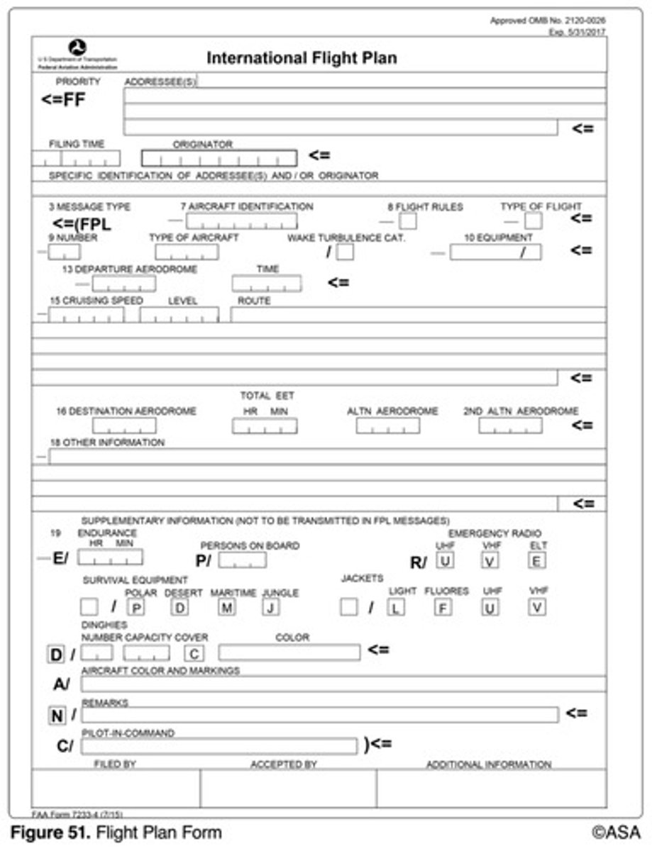
(Refer to Figure 51.) What information should be entered for Item 15, level, on the flight plan form?
VFR cruising altitude.
2 multiple choice options
How should a VFR flight plan be closed at the completion of the flight at a controlled airport?
The pilot must close the flight plan with the FAA upon landing.
2 multiple choice options
(Refer to Figure 25.) Determine the magnetic heading for a flight from Fort Worth Meacham (area 4) to Denton Muni (area 1). The wind is from 330° at 25 knots, the true airspeed is 110 knots, and the magnetic variation is 7° east.
004°.
2 multiple choice options

(Refer to Figure 68.) The line from point A to point B of the wind triangle represents
true airspeed and heading.
2 multiple choice options

(Refer to Figure 26, area 2.) What is the approximate latitude and longitude of Cooperstown Airport?
47°25'N - 98°06'W.
2 multiple choice options

When the course deviation indicator (CDI) needle is centered during an omnireceiver check using a VOR test signal (VOT), the omnibearing selector (OBS) and the TO/FROM indicator should read
0° FROM or 180° TO, regardless of the pilot's position from the VOT.
2 multiple choice options
(Refer to Figure 26.) Determine the magnetic course from Tomlinson Airport (area 1) to Jamestown Airport (area 4).
153°.
2 multiple choice options
(Refer to figure 22.) Determine the magnetic heading for a flight from St. Maries Airport (area 4) to Priest River Airport (area 1). The wind is from 340° at 10 knots, and the true airspeed is 90 knots.
329°.
2 multiple choice options
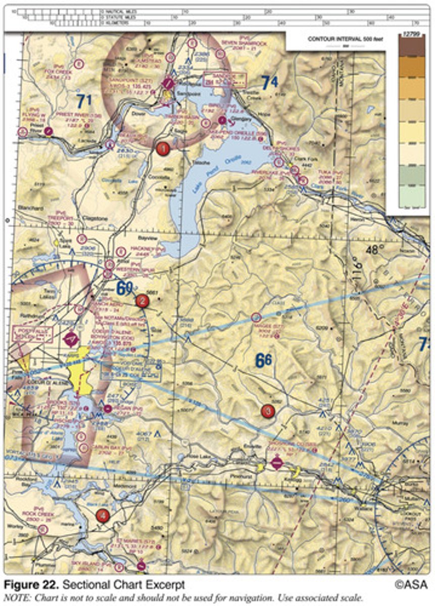
(Refer to Figure 22, area 3.) Determine the approximate latitude and longitude of Shoshone County Airport.
47°33'N - 116°11'W.
2 multiple choice options

(Refer to Figure 28, illustration 7.) The VOR receiver has the indications shown. What is the aircraft's position relative to the station?
Southeast.
2 multiple choice options

(Refer to Figure 23.) The flag symbols at Statesboro Bullock County Airport, Claxton-Evans County Airport, and Ridgeland Airport are
visual checkpoints to identify position for initial callup prior to entering Savannah Class C airspace.
2 multiple choice options

(Refer to Figure 21.) Determine the magnetic heading for a flight from Mercer County Regional Airport (area 3) to Minot International (area 1). The wind is from 330° at 25 knots, the true airspeed is 100 knots, and the magnetic variation is 10° east.
352°.
2 multiple choice options
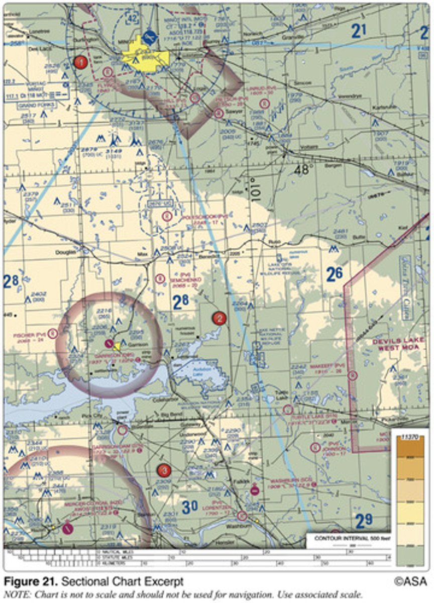
(Refer to Figure 21.) What is the estimated time en route from Mercer County Regional Airport (area 3) to Minot International (area 1)? The wind is from 330° at 25 knots and the true airspeed is 100 knots. Add 3-1/2 minutes for departure and climb-out.
47 minutes.
2 multiple choice options

(Refer to Figure 20.) Determine the magnetic course from First Flight Airport (area 5) to Hampton Roads Airport (area 2).
332°.
2 multiple choice options

(Refer to Figure 24.) On what course should the VOR receiver (OBS) be set in order to navigate direct from Majors Airport (area 1) to Quitman VOR/DME (area 2)?
101°.
2 multiple choice options

(Refer to Figure 24.) Determine the magnetic course from Airpark East Airport (area 1) to Winnsboro Airport (area 2). Magnetic variation is 6°30'E.
075°.
2 multiple choice options
