Urban Studies Images

0.0(0)
Studied by 0 people
call kaiCall Kai
learnLearn
examPractice Test
spaced repetitionSpaced Repetition
heart puzzleMatch
flashcardsFlashcards
GameKnowt Play
Card Sorting

1/22

encourage image

There's no tags or description

Looks like no tags are added yet.

Last updated 1:27 AM on 3/17/26
Name
Mastery
Learn
Test
Matching
Spaced
Call with Kai

No analytics yet

Send a link to your students to track their progress

23 Terms

1
New cards

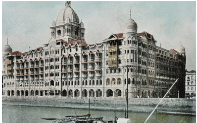
Taj Mahal Hotel, Bombay, Postcard: c. 1900-1930

  • Beautiful building. 

  • Shows British colonization of India, specifically Bombay

  • Contrast: British privilege and development. Have the wealth to colonize. But Indians are the ones building the palace
getting money out of it and extra capital for the nation. Jokes on them jajaja.

<ul><li><p><span style="background-color: transparent;">Beautiful building.&nbsp;</span></p></li><li><p><span style="background-color: transparent;">Shows British colonization of India, specifically Bombay</span></p></li><li><p><span style="background-color: transparent;">Contrast: British privilege and development. Have the wealth to colonize. But Indians are the ones building the palace
getting money out of it and extra capital for the nation. Jokes on them jajaja.</span></p></li></ul><p></p>
2
New cards

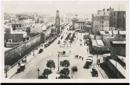
Casablanca, Morocco, Place de France, Postcard:

  • One with ocean in the back. 

  • From an urban studies perspective, postcards of Casablanca from the early 20th century communicated the idea of the city as a modern colonial port and planned urban center within the French imperial system.

  • Example of aerial view images. Used to show the function of a city and how good it is.

<ul><li><p><span style="background-color: transparent;">One with ocean in the back.&nbsp;</span></p></li><li><p><span style="background-color: transparent;">From an urban studies perspective, postcards of Casablanca from the early 20th century communicated the idea of the city as a modern colonial port and planned urban center within the French imperial system.</span></p></li><li><p><span style="background-color: transparent;">Example of aerial view images. Used to show the function of a city and how good it is.</span></p></li></ul><p></p>
3
New cards

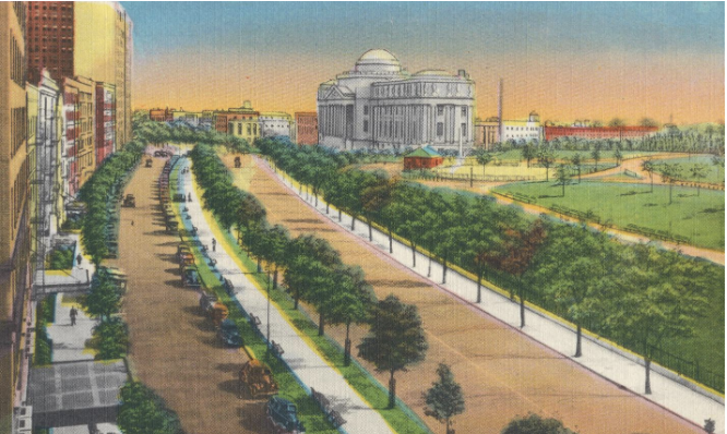
Eastern Parkway, Prospect Heights, Brooklyn, New York City, Postcard:

  • one of the first parkways in the United States, reflecting progressive urban design that integrated transportation, greenery, and leisure.

  • Civic pride and middle-class urban life: The wide streets, elegant apartments, and pedestrians conveyed stability and prosperity. HIGH RISE APARTMENTS. 

  • New York as a global metropolis: By circulating this image, postcards helped frame New York City as a modern, planned, and livable world city, comparable to European capitals.

<ul><li><p><span style="background-color: transparent;">one of the first parkways in the United States, reflecting progressive urban design that integrated transportation, greenery, and leisure.</span></p></li><li><p><span style="background-color: transparent;">Civic pride and middle-class urban life: The wide streets, elegant apartments, and pedestrians conveyed stability and prosperity. HIGH RISE APARTMENTS.&nbsp;</span></p></li><li><p><span style="background-color: transparent;">New York as a global metropolis: By circulating this image, postcards helped frame New York City as a modern, planned, and livable world city, comparable to European capitals.</span></p></li></ul><p></p>
4
New cards

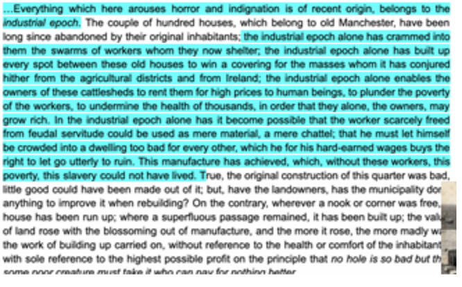
Frederich Engels, The Condition of the Working Class in England (1844)

The Condition of the Working Class in England by Friedrich Engels describes the living conditions of industrial workers in rapidly expanding cities such as Manchester during the Industrial Revolution. Engels details overcrowded housing, pollution, disease, and the spatial segregation between wealthy and working-class neighborhoods. From an urban studies perspective, the text reveals how early industrial urbanization produced extreme social inequality and unhealthy urban environments. It also helped inspire later urban reform movements focused on sanitation, housing, and labor conditions.

<p><span style="background-color: transparent;">The Condition of the Working Class in England by Friedrich Engels describes the living conditions of industrial workers in rapidly expanding cities such as Manchester during the Industrial Revolution. Engels details overcrowded housing, pollution, disease, and the spatial segregation between wealthy and working-class neighborhoods. From an urban studies perspective, the text reveals how early industrial urbanization produced extreme social inequality and unhealthy urban environments. It also helped inspire later urban reform movements focused on sanitation, housing, and labor conditions.</span></p>
5
New cards

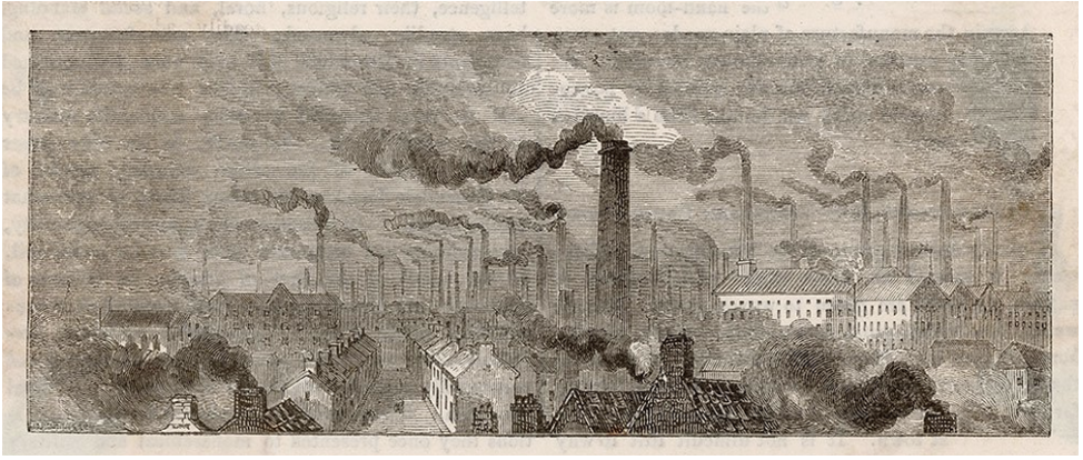
“Manchester, from the Entrance to the London and North-Western Railway” (c. 1840s)

Manchester became one of the first major industrial cities, and this illustration shows the dramatic impact of railroads on the urban landscape. The arrival of the London and North Western Railway symbolized new transportation networks linking industrial cities to national and global markets. Urban space is dominated by factories, smoke, and dense infrastructure, highlighting the transformation of cities into industrial production centers. The image reflects how rail infrastructure reshaped city growth, mobility, and economic geography.

<p><span style="background-color: transparent;">Manchester became one of the first major industrial cities, and this illustration shows the dramatic impact of railroads on the urban landscape. The arrival of the London and North Western Railway symbolized new transportation networks linking industrial cities to national and global markets. Urban space is dominated by factories, smoke, and dense infrastructure, highlighting the transformation of cities into industrial production centers. The image reflects how rail infrastructure reshaped city growth, mobility, and economic geography.</span></p>
6
New cards

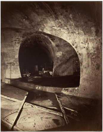
Felix Nadar, “Subterranean Paris (Pont au Change)” (1864–1865)

FĂ©lix Nadar photographed the underground infrastructure of Paris during the modernization of the city. The photograph documents sewer tunnels built during the massive urban renovations under Georges‑EugĂšne Haussmann. From an urban studies perspective, it highlights the importance of invisible infrastructure—sanitation, drainage, and engineering—in creating a modern, healthy city. The image reflects how nineteenth-century urban planning increasingly focused on public health and technological control of the urban environment.

<p><span style="background-color: transparent;">FĂ©lix Nadar photographed the underground infrastructure of Paris during the modernization of the city. The photograph documents sewer tunnels built during the massive urban renovations under Georges‑EugĂšne Haussmann. From an urban studies perspective, it highlights the importance of invisible infrastructure—sanitation, drainage, and engineering—in creating a modern, healthy city. The image reflects how nineteenth-century urban planning increasingly focused on public health and technological control of the urban environment.</span></p>
7
New cards

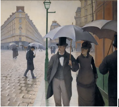
Gustave Caillebotte, Paris Street; Rainy Day (1877)

Paris Street; Rainy Day depicts the wide boulevards and orderly urban space created by Haussmann’s redesign of Paris. The painting emphasizes modern features such as broad streets, uniform buildings, and regulated pedestrian movement. Urban studies scholars view it as a representation of the new bourgeois urban lifestyle produced by modernization. At the same time, Haussmann’s planning displaced working-class communities and created more controlled, surveillable urban spaces. ALSO shows how sewers allowed for non-flooded streets. 

<p><span style="background-color: transparent;">Paris Street; Rainy Day depicts the wide boulevards and orderly urban space created by Haussmann’s redesign of Paris. The painting emphasizes modern features such as broad streets, uniform buildings, and regulated pedestrian movement. Urban studies scholars view it as a representation of the new bourgeois urban lifestyle produced by modernization. At the same time, Haussmann’s planning displaced working-class communities and created more controlled, surveillable urban spaces. ALSO shows how sewers allowed for non-flooded streets.&nbsp;</span></p>
8
New cards

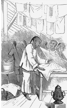
“Loathsome Practice of Mouth Spray in the Chinese Laundries” (1880 illustration)

This illustration reflects anti-Chinese racism in cities like San Francisco during the late nineteenth century. Chinese laundries were common small businesses run by immigrants, but public health rhetoric was often used to portray them as unsanitary and dangerous. From an urban studies perspective, the image shows how ideas about hygiene and disease were used to justify segregation, discrimination, and restrictive policies against immigrant communities. It demonstrates how urban public health debates were intertwined with race and social control.

<p><span style="background-color: transparent;">This illustration reflects anti-Chinese racism in cities like San Francisco during the late nineteenth century. Chinese laundries were common small businesses run by immigrants, but public health rhetoric was often used to portray them as unsanitary and dangerous. From an urban studies perspective, the image shows how ideas about hygiene and disease were used to justify segregation, discrimination, and restrictive policies against immigrant communities. It demonstrates how urban public health debates were intertwined with race and social control.</span></p>
9
New cards

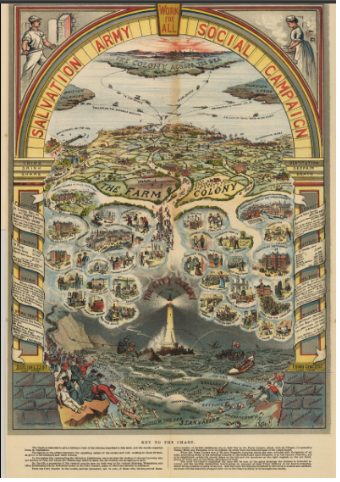
William Booth, In Darkest England, and the Way Out (1890)

William Booth compared urban poverty in London to the “darkest” parts of colonial Africa. His work highlighted homelessness, unemployment, and slum conditions in the rapidly growing industrial city. From an urban studies perspective, Booth framed poverty as a structural urban problem requiring social reform. His proposals contributed to debates about welfare, charity, and urban social policy. It also emphasized the fact that these social reforms would require government control of a cities working and poor class. 

<p><span style="background-color: transparent;">William Booth compared urban poverty in London to the “darkest” parts of colonial Africa. His work highlighted homelessness, unemployment, and slum conditions in the rapidly growing industrial city. From an urban studies perspective, Booth framed poverty as a structural urban problem requiring social reform. His proposals contributed to debates about welfare, charity, and urban social policy. It also emphasized the fact that these social reforms would require government control of a cities working and poor class.&nbsp;</span></p>
10
New cards

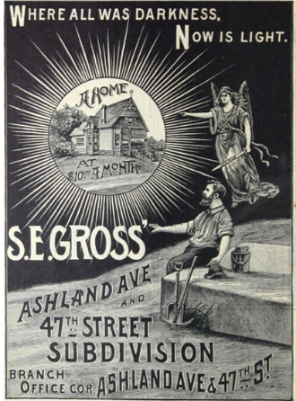
“The Working Man’s Reward,” Chicago Advertisement (1891)

This advertisement reflects the consumer culture emerging in industrial cities such as Chicago. It suggests that wage laborers could achieve comfort, status, and domestic stability through consumption. Urban studies scholars interpret such advertisements as part of the creation of a new working- and middle-class urban identity tied to mass production and consumer markets. The ad also shows how industrial capitalism reshaped everyday urban life and aspirations.

<p><span style="background-color: transparent;">This advertisement reflects the consumer culture emerging in industrial cities such as Chicago. It suggests that wage laborers could achieve comfort, status, and domestic stability through consumption. Urban studies scholars interpret such advertisements as part of the creation of a new working- and middle-class urban identity tied to mass production and consumer markets. The ad also shows how industrial capitalism reshaped everyday urban life and aspirations.</span></p>
11
New cards

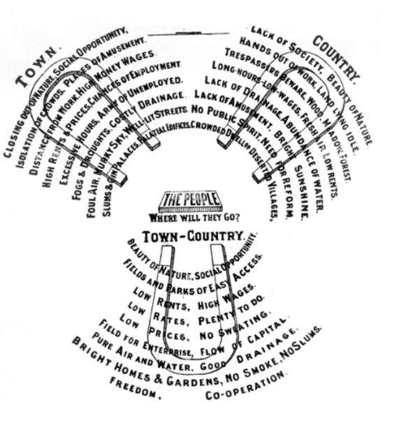
Ebenezer Howard, “The Three Magnets” (1898)

Ebenezer Howard created the “Three Magnets” diagram to explain why people choose to live in either the city or the countryside. His solution was the “Garden City,” combining urban opportunities with rural health and green space. From an urban studies perspective, this diagram represents one of the earliest modern planning theories addressing overcrowded industrial cities. It influenced suburban planning and twentieth-century urban design worldwide.

<p><span style="background-color: transparent;">Ebenezer Howard created the “Three Magnets” diagram to explain why people choose to live in either the city or the countryside. His solution was the “Garden City,” combining urban opportunities with rural health and green space. From an urban studies perspective, this diagram represents one of the earliest modern planning theories addressing overcrowded industrial cities. It influenced suburban planning and twentieth-century urban design worldwide.</span></p>
12
New cards

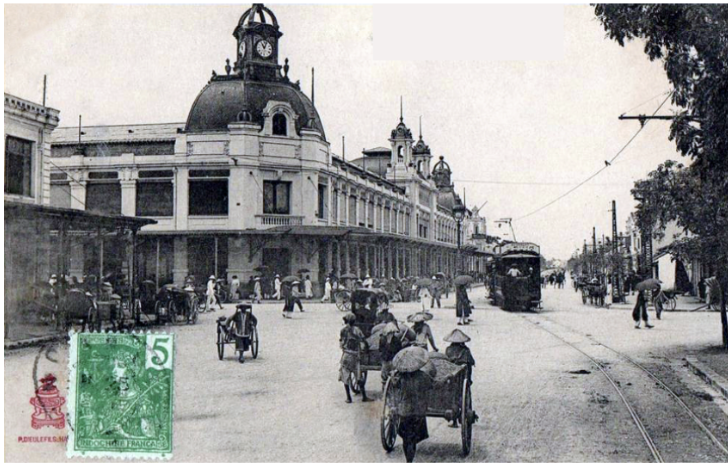
Hanoi, Boulevard Dong-Khanh Postcard (c. 1900)

This postcard shows the colonial urban landscape of Hanoi under French rule in French Indochina. The boulevard represents European-style urban planning imposed on a Southeast Asian city. Colonial authorities redesigned parts of the city with wide streets, administrative buildings, and segregated districts. The image highlights how colonialism reshaped urban space to serve imperial power through exhibition, and economic extraction.

<p><span style="background-color: transparent;">This postcard shows the colonial urban landscape of Hanoi under French rule in French Indochina. The boulevard represents European-style urban planning imposed on a Southeast Asian city. Colonial authorities redesigned parts of the city with wide streets, administrative buildings, and segregated districts. The image highlights how colonialism reshaped urban space to serve imperial power through exhibition, and economic extraction.</span></p>
13
New cards

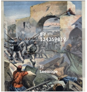
Le Petit Parisien, Casablanca Illustration (1907)

This cover from the French newspaper Le Petit Parisien portrays violence in Casablanca in a way that justified French colonial intervention. Such imagery helped portray colonial conquest as a necessary act of restoring order and civilization. Urban studies perspectives emphasize how media representations framed colonial cities as chaotic or dangerous. These narratives helped legitimize imperial control and urban restructuring.

<p><span style="background-color: transparent;">This cover from the French newspaper Le Petit Parisien portrays violence in Casablanca in a way that justified French colonial intervention. Such imagery helped portray colonial conquest as a necessary act of restoring order and civilization. Urban studies perspectives emphasize how media representations framed colonial cities as chaotic or dangerous. These narratives helped legitimize imperial control and urban restructuring.</span></p>
14
New cards

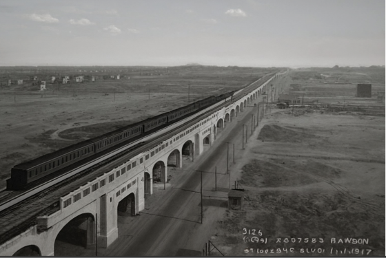
Interborough Rapid Transit Corona Line, Queens Photograph (1917)

The expansion of the Interborough Rapid Transit Company subway into Queens shows how mass transit reshaped metropolitan growth. Subway lines made it possible for people to live farther from city centers while commuting to work. From an urban studies perspective, this infrastructure enabled suburbanization and the expansion of metropolitan regions. Transit systems became key drivers of urban spatial organization.

<p><span style="background-color: transparent;">The expansion of the Interborough Rapid Transit Company subway into Queens shows how mass transit reshaped metropolitan growth. Subway lines made it possible for people to live farther from city centers while commuting to work. From an urban studies perspective, this infrastructure enabled suburbanization and the expansion of metropolitan regions. Transit systems became key drivers of urban spatial organization.</span></p>
15
New cards

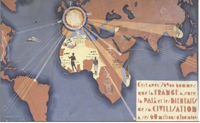
Mission Civilisatrice Illustration (1938)

This propaganda image promotes the French colonial idea of the “civilizing mission.” It portrays France as bringing order, infrastructure, and modernization to colonized regions. Urban studies scholars interpret such imagery as justification for colonial urban planning and economic exploitation. Colonial cities were often redesigned to serve imperial administrative and commercial needs.

<p><span style="background-color: transparent;">This propaganda image promotes the French colonial idea of the “civilizing mission.” It portrays France as bringing order, infrastructure, and modernization to colonized regions. Urban studies scholars interpret such imagery as justification for colonial urban planning and economic exploitation. Colonial cities were often redesigned to serve imperial administrative and commercial needs.</span></p>
16
New cards

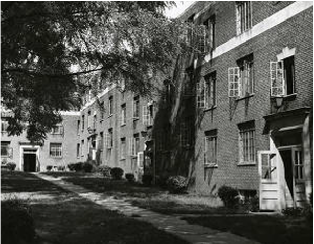
Techwood Homes, Atlanta (c. 1940)

Techwood Homes was one of the first federally funded public housing projects in the United States. Built in Atlanta during the New Deal, it aimed to replace slums with modern housing. From an urban studies perspective, it reflects early government efforts to address urban poverty and housing shortages. However, public housing policies also reinforced racial segregation and displacement.

<p><span style="background-color: transparent;">Techwood Homes was one of the first federally funded public housing projects in the United States. Built in Atlanta during the New Deal, it aimed to replace slums with modern housing. From an urban studies perspective, it reflects early government efforts to address urban poverty and housing shortages. However, public housing policies also reinforced racial segregation and displacement.</span></p>
17
New cards

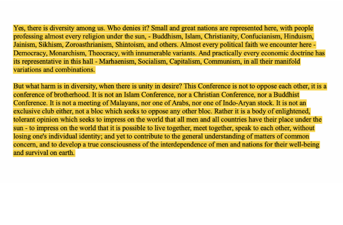
Sukarno, Bandung Afro-Asia Conference Address (1955)

Sukarno delivered this speech at the Bandung Conference in Bandung. The conference brought together leaders of newly independent nations seeking alternatives to colonial domination and Cold War alliances. From an urban studies perspective, the speech reflects the growing political importance of cities in postcolonial international networks. It highlights how urban centers became hubs of diplomacy, nationalism, and global South solidarity.

<p><span style="background-color: transparent;">Sukarno delivered this speech at the Bandung Conference in Bandung. The conference brought together leaders of newly independent nations seeking alternatives to colonial domination and Cold War alliances. From an urban studies perspective, the speech reflects the growing political importance of cities in postcolonial international networks. It highlights how urban centers became hubs of diplomacy, nationalism, and global South solidarity.</span></p>
18
New cards

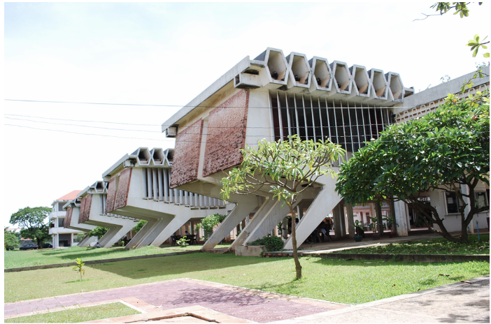
Royal University of Phnom Penh Teaching Rooms (1950s)

Royal University of Phnom Penh represents educational modernization in Phnom Penh during the postcolonial period. Universities symbolized national development, modernization, and the training of new professional elites. Urban studies perspectives emphasize how educational institutions shape intellectual and political life in cities. They also anchor cultural and administrative networks in national capitals.

<p><span style="background-color: transparent;">Royal University of Phnom Penh represents educational modernization in Phnom Penh during the postcolonial period. Universities symbolized national development, modernization, and the training of new professional elites. Urban studies perspectives emphasize how educational institutions shape intellectual and political life in cities. They also anchor cultural and administrative networks in national capitals.</span></p>
19
New cards

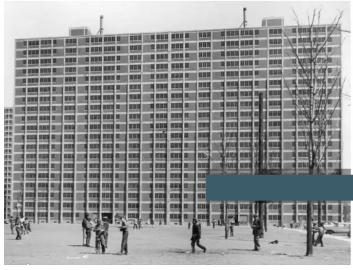
Cabrini-Green Housing Project, Chicago (1960s)


Cabrini-Green Homes in Chicago became one of the most famous public housing developments in the United States. Built to address housing shortages, it eventually became associated with concentrated poverty and urban neglect. From an urban studies perspective, Cabrini-Green illustrates the limits of mid-twentieth-century public housing policy. It highlights how design, segregation, and economic inequality shaped urban life.

<p><br></p><p><span style="background-color: transparent;">Cabrini-Green Homes in Chicago became one of the most famous public housing developments in the United States. Built to address housing shortages, it eventually became associated with concentrated poverty and urban neglect. From an urban studies perspective, Cabrini-Green illustrates the limits of mid-twentieth-century public housing policy. It highlights how design, segregation, and economic inequality shaped urban life.</span></p>
20
New cards

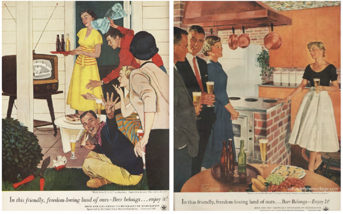
United States Brewers Foundation Advertisement (1960s)

United States Brewers Foundation created advertisements linking beer consumption with American identity and leisure. These ads reflected suburban lifestyles and postwar prosperity in the United States. Urban studies scholars view such imagery as part of the broader culture of consumerism shaping metropolitan life. It also illustrates how advertising helped construct a national urban middle-class identity.

<p><span style="background-color: transparent;">United States Brewers Foundation created advertisements linking beer consumption with American identity and leisure. These ads reflected suburban lifestyles and postwar prosperity in the United States. Urban studies scholars view such imagery as part of the broader culture of consumerism shaping metropolitan life. It also illustrates how advertising helped construct a national urban middle-class identity.</span></p>
21
New cards

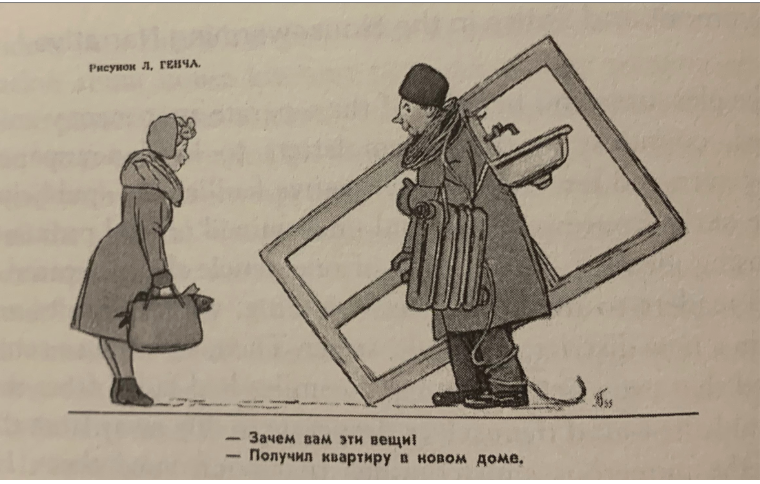
Soviet Satirical Cartoon: “I received an apartment in a new building!” (1960–1980)

This cartoon critiques housing shortages in the Soviet Union. Although the government built large apartment blocks to house urban populations, residents often lacked furniture or consumer goods. From an urban studies perspective, it reflects the gap between state promises of modern housing and everyday realities. It also highlights the challenges of mass urbanization under centralized planning.

<p><span style="background-color: transparent;">This cartoon critiques housing shortages in the Soviet Union. Although the government built large apartment blocks to house urban populations, residents often lacked furniture or consumer goods. From an urban studies perspective, it reflects the gap between state promises of modern housing and everyday realities. It also highlights the challenges of mass urbanization under centralized planning.</span></p>
22
New cards

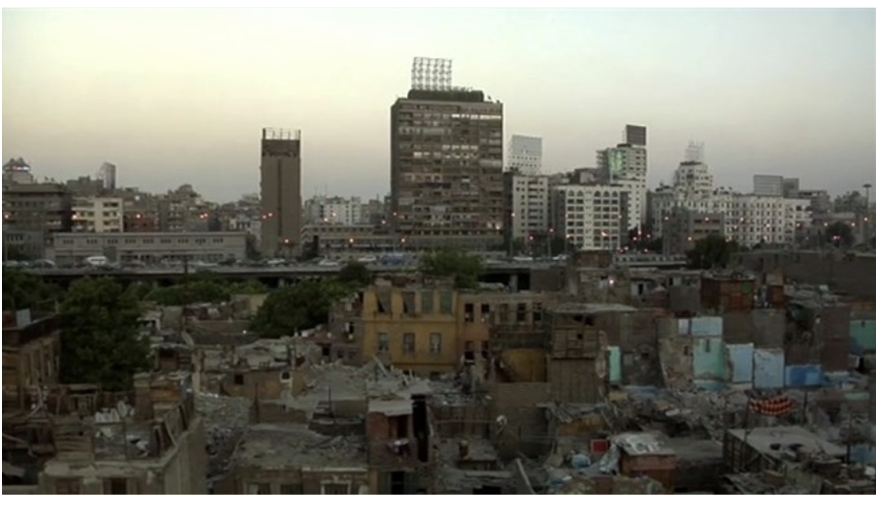
Bulaq, Cairo Photograph (post-2011

Bulaq is a dense, working-class district in Cairo. The image reflects informal urban life and the social tensions that intensified after the Egyptian Revolution of 2011. Urban studies scholars often examine neighborhoods like Bulaq to understand inequality, informal housing, and political activism in global megacities. It highlights how contemporary urban spaces are shaped by economic pressures and grassroots resistance.

<p><span style="background-color: transparent;">Bulaq is a dense, working-class district in Cairo. The image reflects informal urban life and the social tensions that intensified after the Egyptian Revolution of 2011. Urban studies scholars often examine neighborhoods like Bulaq to understand inequality, informal housing, and political activism in global megacities. It highlights how contemporary urban spaces are shaped by economic pressures and grassroots resistance.</span></p>
23
New cards

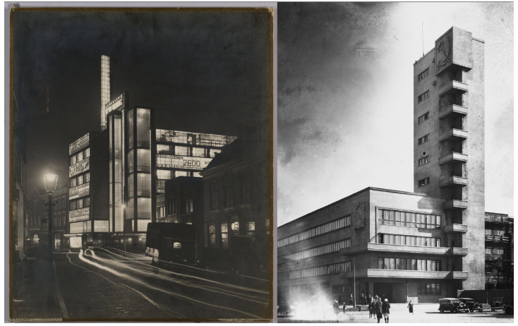
Soviet Urban Architecture and Street Scenes (c. 1925–1940)

These photographs show cities in the Soviet Union during a period of rapid industrialization and socialist planning. Urban architecture emphasized monumental buildings, collective housing, and wide public spaces. From an urban studies perspective, Soviet cities were designed to reflect socialist ideals of collective life and state control over production and housing. The built environment served both ideological and practical purposes.

<p><span style="background-color: transparent;">These photographs show cities in the Soviet Union during a period of rapid industrialization and socialist planning. Urban architecture emphasized monumental buildings, collective housing, and wide public spaces. From an urban studies perspective, Soviet cities were designed to reflect socialist ideals of collective life and state control over production and housing. The built environment served both ideological and practical purposes.</span></p>

Explore top flashcards

flashcards
VPAR 132 Final Lab Exam
268
Updated 112d ago
0.0(0)
flashcards
Aboriginal Spirituality
40
Updated 864d ago
0.0(0)
flashcards
Spanish Vocab 1.1
30
Updated 910d ago
0.0(0)
flashcards
Battle of the Books 2024-2025
28
Updated 517d ago
0.0(0)
flashcards
Allusions Research
181
Updated 841d ago
0.0(0)
flashcards
Review: Science Exam
58
Updated 1197d ago
0.0(0)
flashcards
World Lit.
40
Updated 1134d ago
0.0(0)
flashcards
VPAR 132 Final Lab Exam
268
Updated 112d ago
0.0(0)
flashcards
Aboriginal Spirituality
40
Updated 864d ago
0.0(0)
flashcards
Spanish Vocab 1.1
30
Updated 910d ago
0.0(0)
flashcards
Battle of the Books 2024-2025
28
Updated 517d ago
0.0(0)
flashcards
Allusions Research
181
Updated 841d ago
0.0(0)
flashcards
Review: Science Exam
58
Updated 1197d ago
0.0(0)
flashcards
World Lit.
40
Updated 1134d ago
0.0(0)