10) Regional Groundwater flow
1/58
There's no tags or description
Looks like no tags are added yet.
Name | Mastery | Learn | Test | Matching | Spaced | Call with Kai |
|---|
No analytics yet
Send a link to your students to track their progress
59 Terms
what is a recharge area
flow directed downward at the water table
occurs under topographic highs (hills)
generally larger than discharge areas
what is a discharge area
flow directed upward at the water table
smaller than recharge areas (usually 5-30% of watershed area)
generally higher flux than recharge areas
occur under topographic lows (valleys)
what is a hinge line
separates recharge areas from discharge areas
is precipitation counted on stream? why?
no, because its such a small area of the watershed, its insignificant, but on recharge area its much larger, so it matters
what are the 3 major influences on regional groundwater flow patterns?
topographic driving forces (water table configuration)
basin geometry (ratio of depth to lateral extent)
basin geology (variations in K from heterogeneity and anisotropy due to layering)
how does topography influence groundwater flow
water table mimics surface water boundary
undulating water table results in complex flow patterns having multiple recharge and discharge areas
local flow systems are superimposed on top of intermediate and regional flow systems
short range flow system (shaded region) is superimposed on top of a longer-range flow system
more local pathways
what are the types of flow systems and details on them
intermediate: at least one local flow system between their recharge and discharge
regional: recharge area in the basin divide and the discharge area in the valley bottom, traverse entire system
local: recharge and discharge are not interrupted by any other flow system
what is a stagnation point
where three flow systems intersect
magnitudes of the vectors in the flow field are equal but opposite in direction and cancel each other out
can also be near impermeable boundaries
how does basin geometry influence groundwater flow
ratio of groundwater basin depth to lateral extend
shallow long basin or deep sedimentary basin
in a deep basin, water moves slowly and circulates deeply
how does heterogeneity influence groundwater flow systems
groundwater flow systems typically comprised of horizontal or slightly sloping layers. different layer shave varying K values
groundwater preferentially flows along high K layers and across low K layers
shapes and patterns, layers and characteristics
how does flow in low K over high K with an increasing difference between the K values
as the difference increases, the low K zone adopts more vertical flow because more flow is carried in the lower unit
how is flow influenced with a high K layer over a low K layer
potential field is similar to isotropic aquifer, most flow is carried in upper, more conductive layer
how is flow influenced with a low K layer over a high K layer
depending on the difference in orders of magnitude, flow will flow towards the high K layer, varying degrees of vertical-ness, and then flow horizontally in the high K layer
details about low K over high K situation
represents confined aquifer
hydraulic gradient is greater in the confining bed
frictional resistance to flow is greater in confining layer, most of available energy is dissipated there
what is the prairie profile? why does saline soil occur in discharge areas there?
higher K layers at depth, where clay-rich glacial til is underlain by inter-till aquifers
due to evaporation
what are flow reversals? what causes them?
where flow is not in the same direction as the majority of the flow in the area
undulating water table
how does anisotropy influence groundwater flow
when horizontal conductivity is greater than vertical, flow paths tend to be shallower
explain this
a) homogeneous, isotropic: more evenly distributes groundwater to multiple areas
b) overlying low K: more vertical movement, the higher topographic streams will dry up, all water flows straight down and away, then converges in lower stream
c) overlying high K: may see seepage face, water table intersecting with ground
what are groundwater functions in relation to streams?
maintain baseflow during dry periods
regulate temperature of water around springs
bring nutrients into the stream
support stream-side (riparian) vegetation
higher topographic system is usually __?
recharge area
types of groundwater interactions with streams
gaining streams
losing streams
bank storage
flow through
parallel flow
coastline exchange
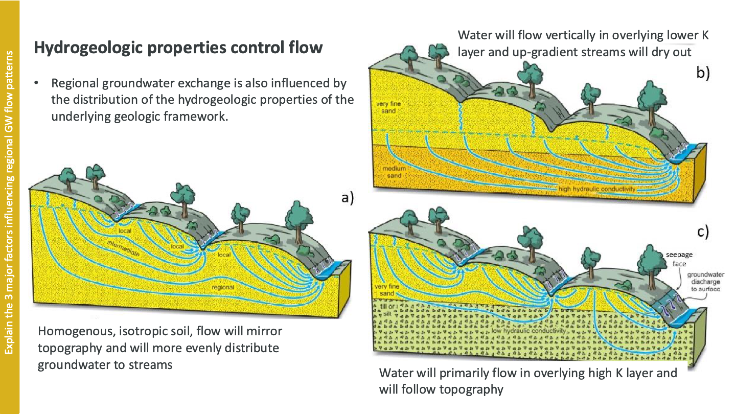
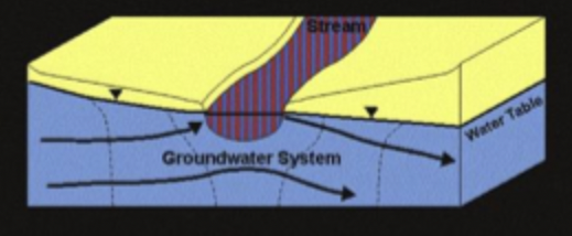
details on gaining streams
water table at the stream is lower than surrounding groundwater
groundwater gradients are upward
maintains baseflow
GW flow converges and equip lines point upstream
in map view, what does a V pointing upstream indicate?
gaining stream
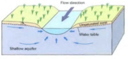
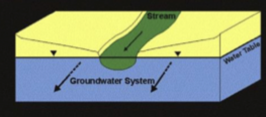
details on losing streams
can be connected or disconnected from stream
when connected, water flows directly from stream channel into adjacent groundwater
when disconnected, WT mound below stream
GW flow diverges and equip lines point downstream
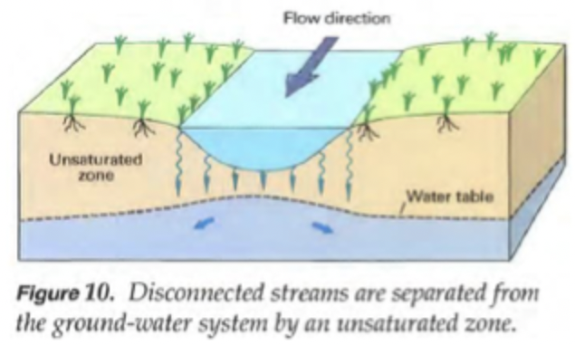
details on bank storage
as stream level rises during rainfall, gradients can be reversed causing water to flow from stream into subsurface along banks
can cause significant flooding
details on flow-through streams
WT adjacent to the stream is higher on one side of the channel where GW enters and lower on the opposite side where GW exits
equip lines are parallel to stream channel
details on zero-exchange streams
parallel flow
local water table elevation mirrors the stream stage
zero exchange
no gradient, WT contours the stream at right angles and flow is parallel to the channel
details on coastal-exchange streams
presence of brackish and seawter
GW discharges when the shoreline WT is higher than the ocean stage
ocean levels rise higher than the groundwater levels, seawater infiltrates into shallow groundwater system
flow through conditions not applicable, but zero-exchange occurs
what do location and magnitude of GW-SW exchange depend on?
natural distribution of heads, hydraulic conductivity, anisotropy distributions, boundary conditions
what does presence of anisotropic conditions cause?
directs flow preferentially to zones of higher hydraulic conductivity
what does low permeability cause in heterogeneous settings?
limited movement of exchange waters in the subsurface
details on perennial streams
permanent streams defined by water flowing all year
common with abundant rainfall, groundwater discharge, low rates of evaporation
details on ephemeral streams
don’t flow all year, only in response to precipitation
common with low annual rainfall, low water table, high rates of evaporation
which type of flow is the largest component during a storm? what is it?
overland flow
when precipitation rate exceeds infiltration capacity of the soil, occurs only during intense storms or when soil is saturated or frozen
more common in urban areas
old water vs new water
old water: been in the watershed for a while (could be soil water, groundwater, etc)
new water: water added to watershed during precipitation event
what is celerity? how is it different from velocity?
rate at which hydraulic head “wave” propagates from one pond to another
vastly greater than velocity which is how fast water moves through the aquifer
true or false: a stream can be gaining and losing at the same time
true, at different locations along the stream conditions can be different
what is depression focused recharge
hummocky (moundy), terrain creates closed drainage basins where rainfall collects in topographical depressions
is it more saline in discharge or recharge areas
discharge, and may have more salt tolerant vegetation
recharge has more flushing of water, less saline
when is depression focused recharge most likely?
in spring due to snowmelt
K in surficial sediments often ___ with depth, why?
decreases
compaction and reduced porosity
cementation and diagenesis
decrease in bioturbation and root activity
lower fracture density
how can vegetation affect seepage patterns?
transpiration causes surface water to move into GW during day and GW to move into surface water at night
what does rate of water flowing into stream depend on?
hydraulic gradient
hydraulic conductivity of stream bed and aquifer
what is hyporheic exchange? associated with? results in?
localized recharge and discharge
associated with changes in streambed topography or meandering streams
results in zone of increased chemical and microbiological activity near streams and rivers
mixing in anaerobic and aerobic
what are hyporheic zones
hotspots for biological and chemical activity that alter stream chemistry and biology
types of springs
depression, contact, joint/fracture, fault, shear/fault zone, karst
what are ways to estimate GW-SW interaction
mini-piezometer
seepage meter
water balance
hydrograph separation and tracers
models
temperature tracers
what is a seepage meter
seepage from bottom sediment collected in plastic bag to estimate q from q=Q/A
show highly variable flow from point to point
how can we use water balance to estimate GW flux?
input flux - output flux
precipitation + surface inflow + GW inflow - evaporation/transpiration - surface outflow - GW outflow
example of two groundwater flow regimes
later in summer, more stable, deeper GW flow paths
earlier in summer, responsive to fluctuations in precip and snowmelt, shallower flow paths
how can tracers be used for GW estimates
determine source areas of water and dissolved chemicals in basins
calculate hydrologic and chemical fluxes between GW and SW
calculate water ages
determine average rates of chemical reactions during transport
how do we use isotopes to determine GW-SW interactions
assume significantly different sources, the event maintains constant isotopic content
have to see vastly different isotope content for method to work

how do we use temperature methods to estimate GW interactions
fluxes into or out of a stream can be measured indirectly using subsurface temperatures
quantified based on the shift in amplitude and phase of surface T fluctuations (usually diurnal)
lakes vs streams in groundwater interactions
lakes: less rapid water level change
less surface area
bank storage less important
less shading = more evaporation
more organic deposits in sediments
groundwater discharge to lakes is generally greatest ___?
near shore
where do wetlands form? how?
areas of groundwater discharge
due to complex local and regional flow systems or along groundwater springs that form near topographical breaks
resiliency of fen vs bog
fen: recharging, more resilient to water loss
bog: not recharging, sever water table drop if that happened
types of overland flow
hortonian: rainfall exceeds infiltration capacity of soils, rainfall collected on surface moves as a thin sheet of water. controlled by infiltration rate
partial area: infiltration capacity may only be exceeded in riparian areas
saturation overland: direct water input to saturated area plus return flow contributed by groundwater coming out of land
subsurface storm flow: movement of water through unsaturated zone in downslope to stream
macropore flow: when water surrounding soil is not saturated, bypass flow
saturated wedge throughflow: impermeable layers and/or significant soil textural contrasts exist at depth, can rapidly reach stream, bypassing deeper permeable layers
groundwater ridging: small increases in soil moisture results in bump in water table (it’s the capillary fringe)
transmissivity feedback: more porous soils tend to be near surface, water table rises and rapid delivery of lateral flow
saturated areas are ___ later in the year
smaller