BIOL 3450 Oceans Final Stuff
1/100
There's no tags or description
Looks like no tags are added yet.
Name | Mastery | Learn | Test | Matching | Spaced | Call with Kai |
|---|
No analytics yet
Send a link to your students to track their progress
101 Terms
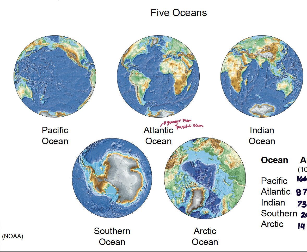
what are the five oceans? how big are they?
Pacific Ocean: area = 166 million km2; depth (average) = 4282 m
Atlantic Ocean: area = 87 million km2; depth = 3926 m
Indian Ocean: area = 73 million km2; depth = 3963 m
Southern Ocean: area = 20 million km2; depth = 4000 m
Ocean: area = 14 million km2; depth = 1205 m
what is the difference in area, proportion (of the globe), and elevation vs. depth between the ocean and the land?
area
land = 149 million km2
ocean = 361 million km2
proportion
land = 29.2%
ocean = 70.8%
elevation vs. depth
land elevation: min = -418 m; max = 8,848 m; mean = 840 m
ocean depth: min = 0 m; max = 10,935 m; mean = 3,688 m
what percentage of the ocean’s area is made up of ridges, rises, and plateaus?
around 30%
what is the difference in the oceanic and continental lithosphere?
the oceanic lithosphere is made up of mainly salat material, which is less dense than granite, what makes up the continental lithosphere
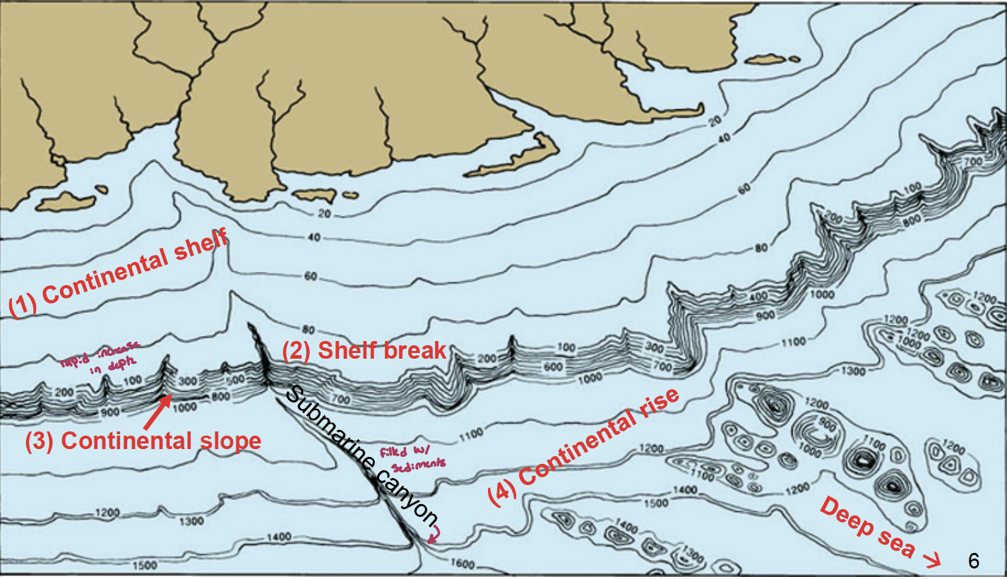
what are the main features of the continental margin from closest the furthest from the land?
continental shelf: shallow, around 130-140 m in depth; submerged margins of the actual continent at the edge of the continent; covers around 18% of the land surface with a width on average of about 65 km (due to tectonics this varies a lot, with larger withs being associated with being further from divergent zones of plates and increase in the northern hemisphere); sea level fluctuation changes the continental shelf, when glaciers melted, the water level dropped
the continental shelf houses some of the most productive areas in the world due to phytoplankton needing light and nutrients and the continental shelf is an area that can be mixed by storms
shelf break: around 140 meters
can have a submarine canyon associated with it filled with sediments
continental slope: rapid increase in depth
continental rise: has a layer of sediments with varying thickness (may be a trench)
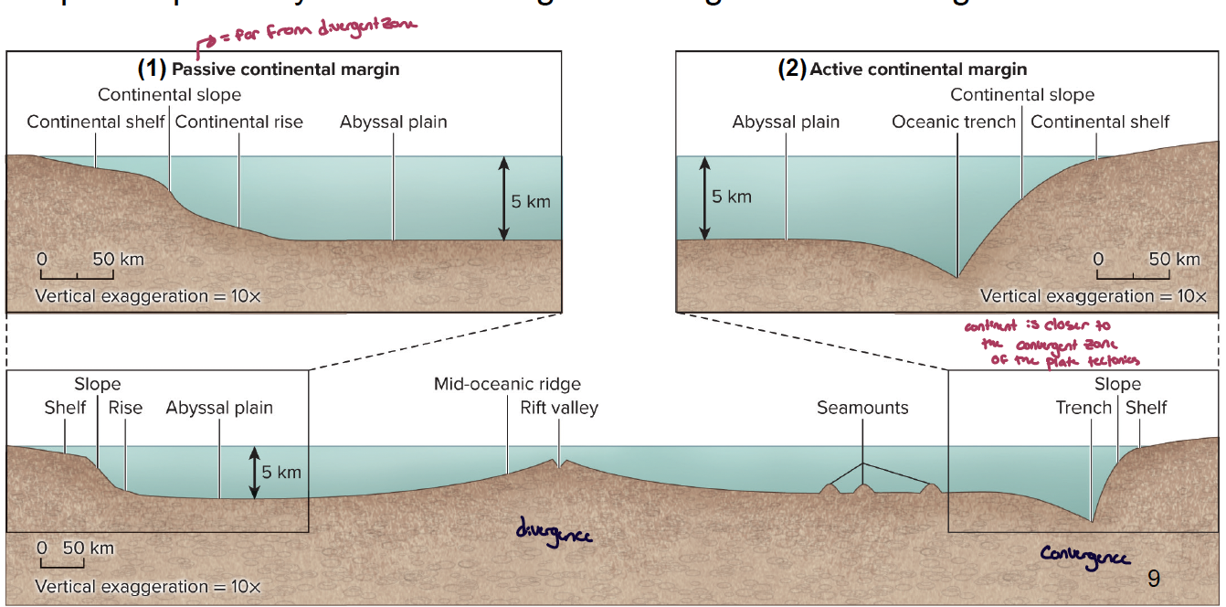
what influences continental margins?
they are strongly influenced by plate tectonics, especially with respect to proximity of coastal margin to divergence or convergence zones
you can have two duties of continental margins:
passive continental margin: far from a divergent zone - has a less steep continental slope and longer continental shelf
active continental margin: the continent is closer to the convergent zone of the plate tectonics - has an oceanic trench instead of a continental rise
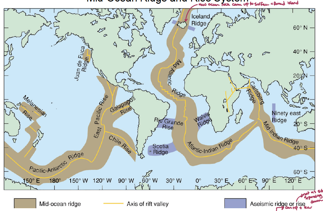
what is the difference between the mid ocean ridge and rise system?
it is a 65,000 km mountainous chain (recent basalt, 2 km high) at spreading (can rip and tear) center, can (1) be displaced by transform faults (fracture zones) & (2) form islands
rise is less steep due to it separating faster leading to the rock cooling down quicker
what are oceanic trenches?
arc-shaped depression in the deep ocean floor where a converging plant is subducted (the deepest one is the Mariana Trench (~11 km deep))
what are the characteristics of the abyssal plains (what can be there) (4)?
abyssal plains: flat, featureless sediment (<1 km thick); represents over 30% of the surface of earth surface (3700 – 5500 m); Isolated, occur between continental margin & ridge system
abyssal hills: extinct volcanoes that can stick out less than 200 m out of the sediment
sea mounts: extinct volcanoes that are 1-4 km high but do not extend to the sea surface
guyot: once above sea surface, now flat from erosion
volcanic islands: when volcanoes reach the surface (ie. Hawaii)
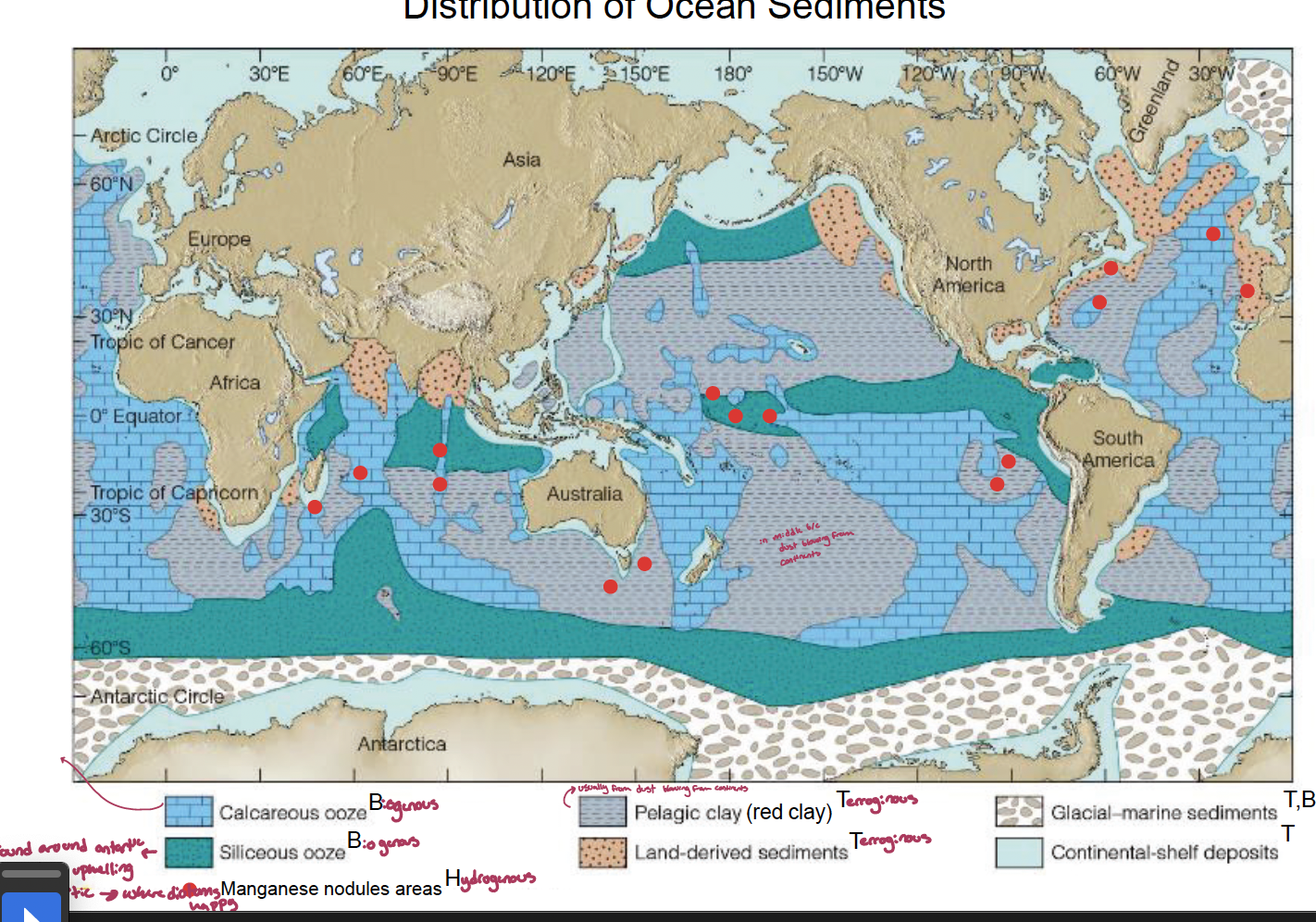
what are the major types of ocean sediments (4)? what are they from and where do they settle? examples?
lithogenous (terrigenous): form from eroded rock, volcanoes, and airborne dust. mainly settle in neritic areas and some pelagic areas of low productivity
ie.coarse beach and shelf deposits, turbidites, red clay.
Yukon delta, AK
biogenous: from living organisms (exoskeletons/cell walls). mainly settle in pelagic zones, regions of high surface productivity, areas of upwelling, some beaches, and shallow warm water. there are two types:
siliceous: silicate (diatoms and radiolarians) over 30% make up siliceous ooze
calcareous: calcium carbonate (coccolithophore, foraminifera (protozoa ameobas that live in cells), and pteropod (zooplankton with a shell inside the body, swimming snails/angels))
hydrogenous: came out of solutions, chemical precipitation from sea water. mainly found at mid-ocean ridges, areas starved of other sediment types, can be neritic or pelagic
metal sulfides, manganese nodules, phosphates, come carbonates
cosmogenous: sediments from outer space. found everywhere but in very low concentrations.
meteorites, space dust, tektite-like glass?
why is there a calcium carbonate compensation depth? what are the two compensation depths of calcium carbonate? what about silicious oozes?
because below the compensation depth (around 4,500 meters), water holds more carbon dioxide, which results in more carbonic acids what dissolves CaCO3 faster.
forms
aragonite compenationd depth (3000m) - usually the stuff in coral reefs
calcite (carbonate) compensation depth (4500m)
silicious oozes are found both above and below the carbonate compensation depth, however below the CCD it is the only one found
what is the difference in the origin of sediments between neritic and pelagic deposits?
neritic: sediments from nearby continents, but only above the continental shelf
pelagic: sediments that cam from the oven water of the ocean (pelagic zone)
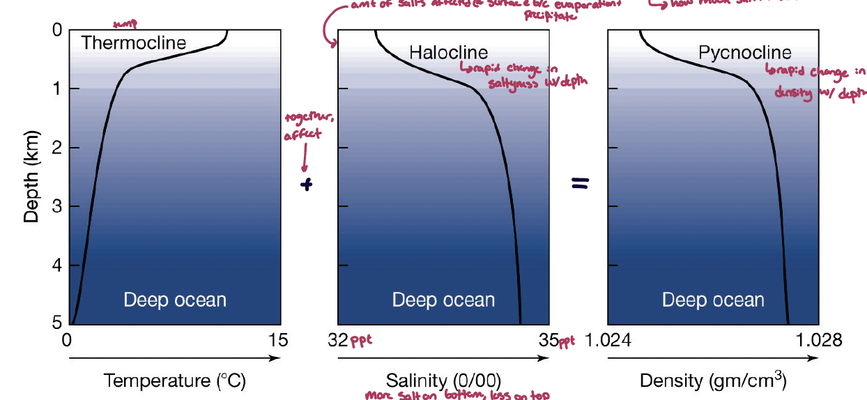
what is the veritable structure of the ocean?
the ocean has stratification due t temperature. it is stratisfied into three leaves despite repeated missing by winds and surface currents
mixed (surface) layer: from surface to about 200 meters deep. this warm layer stays well mixed (isothermal) most of the year
intermediate layer: between 200-1000 meters down. within the sharp tnereatature change (thermocline). less rising occurs in this layer
bottom layer: over 1000 meters deep. this later is normally uniform and cold that has lower levels of mixing
what are the three stratification structures in the ocean? what are the three factors that affect them?
stratification is due to temperature and salinity
thermocline: temperature based
halocline: salinity based. rapid change in saltiness with depth. the amount of autos affected at the surface because of evaporation and precipitate. more slat on the bottom, less on top (inverse)
together, the thermocline and halocline affect the pycnocline.
pycnocline: rapid change in density with depth
effectors
surface currents: from the surface to around 100 meters down driven by winds and cooling and deeper by precipitation vs evaporation (if the water evaporates faster than the water is more salty on the surface)
intermediate currents: from 500-1000 meters down. colder and more saline (saltier) waters occur within the sharp density change (pycnocline)
deep ocean currents/thermohaline circulation: pretty constant. occurs below the pycnocline (~1000 m). relatively cold dens water, motion due to temperature and salinity
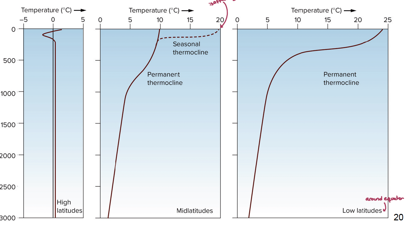
what are the differences in seasonal vs. permanent thermocline? where does each tend to happen?
seasonal: there are latitudinal differences in the seasonal thermocline due to seasonal heating. there is a permanent thermocline where the top 100-200 meters of water can fluctuate in temperature due to the atmosphere affecting it
occurs around midlatitudes
permanent: where the thermocline does not change with the time of the year. occurs at low latitudes (the equator) as well as high latitudes (cold as balls)
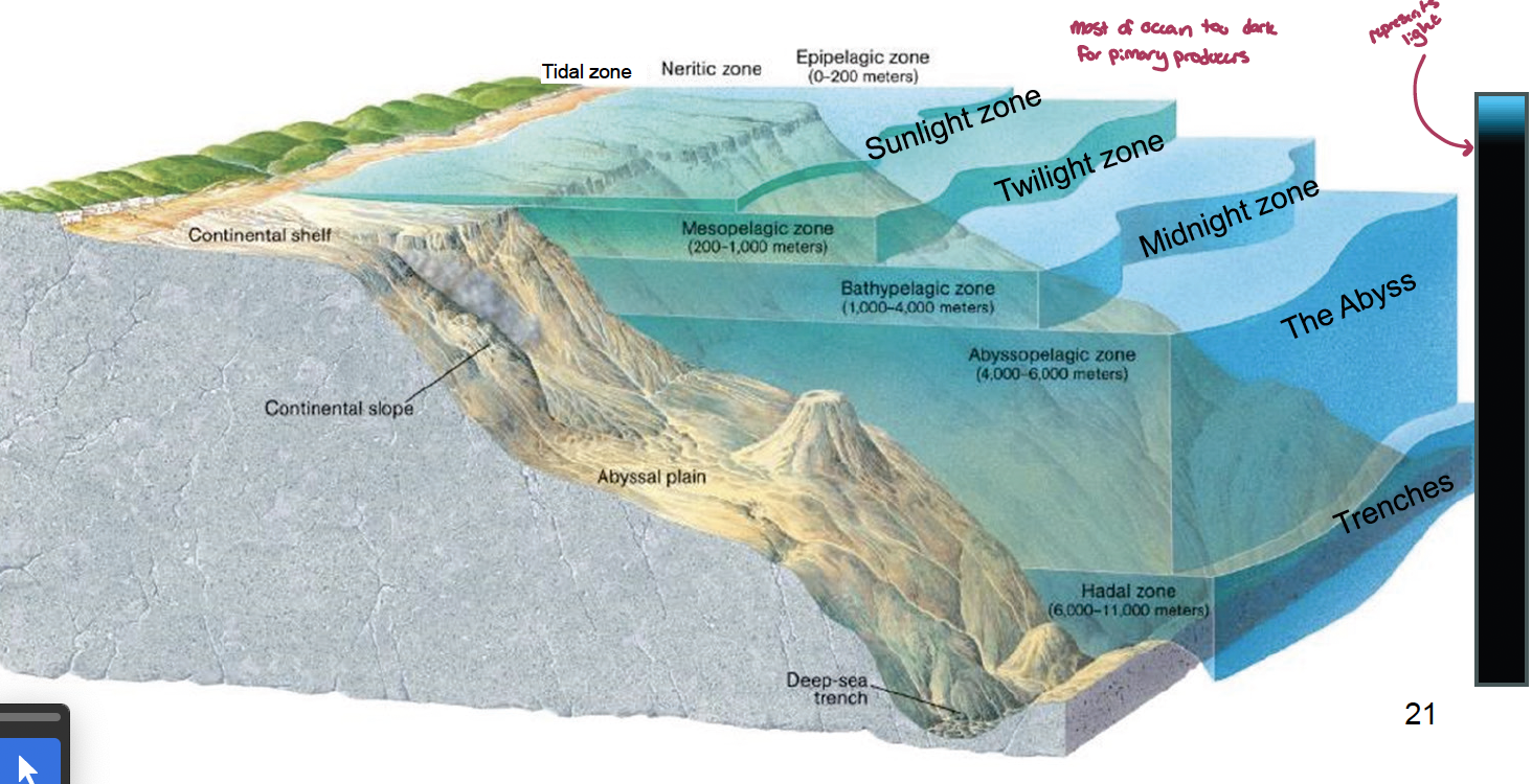
what determines vertical zonation in the ocean? what re the zones()?
zonation is determined by two factors:
depth of pycnocline: affects mixing, temperatures, salinity, dissolved oxygen
depth of light penetration: affects how much oxygen verses carbon dioxide is in the water
zones of the ocean
sunlight zone (tidal zone + neritic zone = epipelagic zone; 0-200 m)
twilight zones (mesopelagic zone; 200-1000 m)
midnight zone (bathypelagic zone; 1000-4000 m)
the abyss (abyssopelagic zone; 4000-6000 m)
trenches (hadal zone; 6000 - 11,000 m)
what are the main physical and chemical interacts that happen in the ocean (2)?
wind stress: 10 hours of wind stress leads to surface currents downwind, with current speed being around 3% of wind speeds
salt fingering layers: evaporation increases salt concentrations of some fluid
lecture 14
what are the main atmosphere-ocean interactions (2+3)?
there is a wide range of interaction of difffering scale, which are all ultimately linked to solar radiation (weather) that occurs in the troposphere (within 10 km of the earth’s surface)
warm air is less dense and holds more water and rises (warm wet air can still rise because the molecular weight of water (18) is lighter than O2 and N2(35)) while cold air is denser and sinks (it doesn’t hold as much water so when warm moist air gets cold, it expels the water, leading to rain/snow)
there is a balance of energy input (its nor uniform everywhere on the planet) vs. output. this depends on:
dust and vapor/gases (lots of this can retain water, leading to the greenhouse effect), reflectivity, angel of the sun
significant regional differences exist due to differences in energy between the equator and the poles
significant seasonal differences exist due to the obliquity of the earth relative to the sun
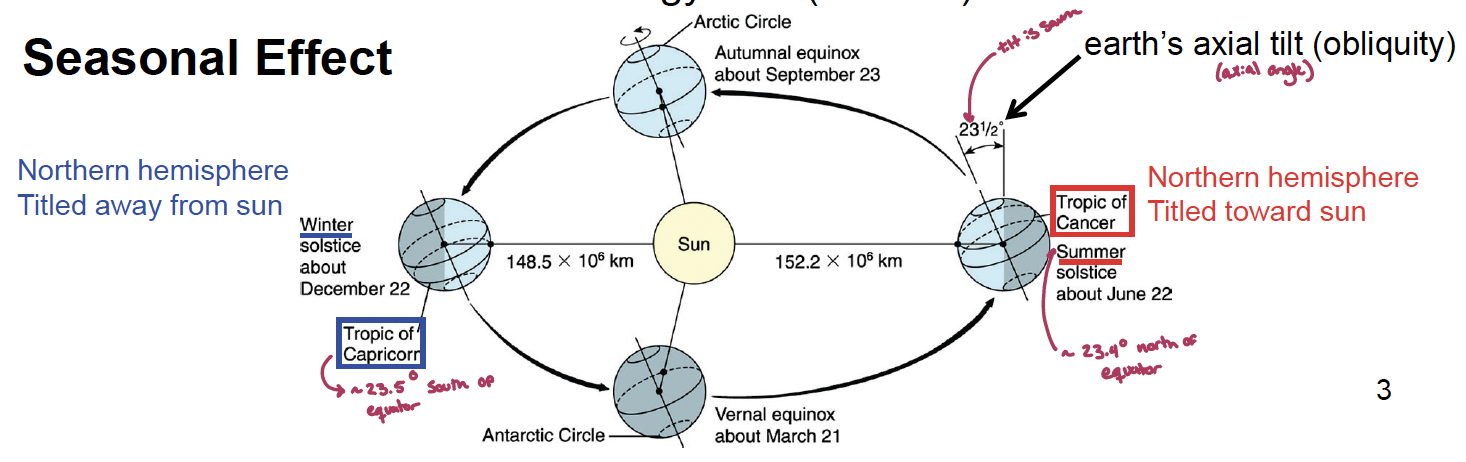
what is the seasonal effect on oceans solar energy flux?
earths axial tilt. (obliquity):
the northern hemisphere is tilted towards the sun towards the tropic of cancer in the summer (~23.4° north of the equator)
it is tiled to the tropic of Capricorn in the winter (~23.5° south of the equator)
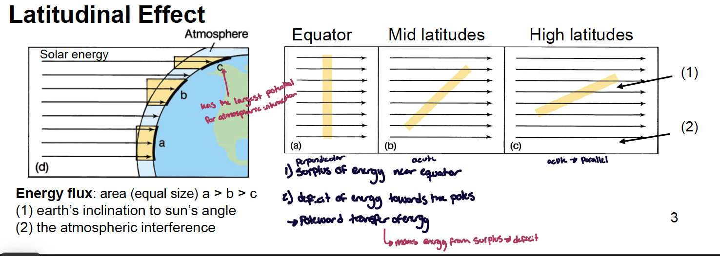
what is the latitudinal effect on oceans solar energy?
the energy flux depends on two things:
the earths inclination to the sun’s angle
the atmospheric interference
the poles have the largest potential for atmospheric interactions
there is a surplus of energy near the equator and e deficit tears the poles. due to this there is poleward trader of energy (energy moves from surplus → deficit)
what is a convection current? what does it mean for energy transfer on earth?
convection current: forms when air flows from a hot area to a cold area and back completing the loop.
hot air in the tropics expands, rises, and converges at the cold poles where it cools, sinks to the surface, and flows back to the tropics, completing the loop. however, each is spinning, effecting fluids that go in the convection cell (coriolis effect)
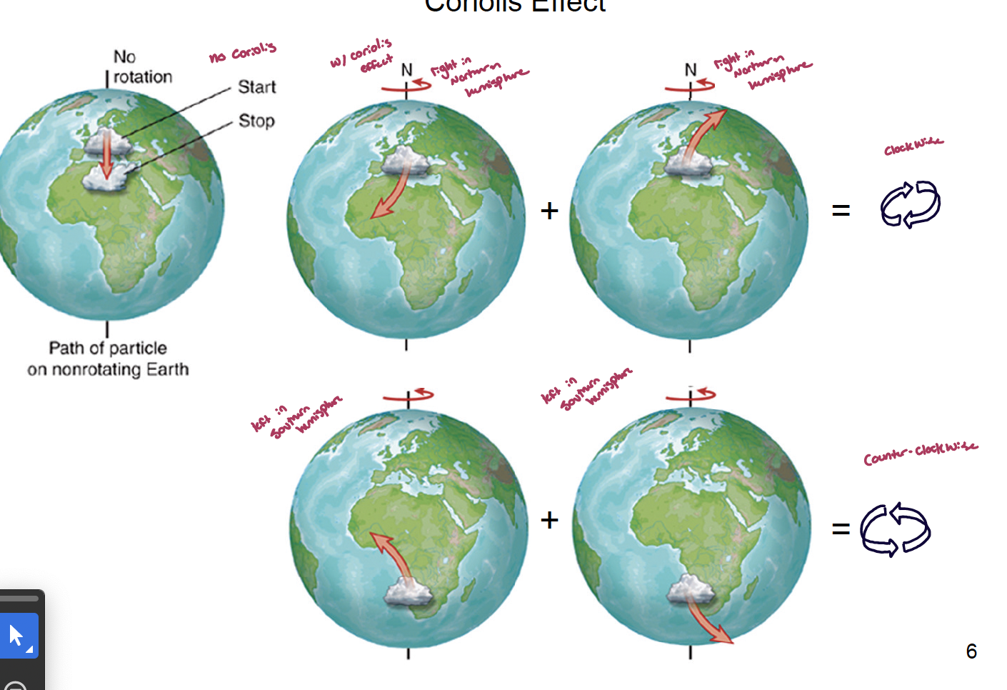
what is the Coriolis effect and what influences it?
the coriolis effect is an artificial force needed to compensate for motions on a rotating sphere as vied from a. fused pint of reference (the further you are from the equator the greater the coriolis effect)
there is no coriolis effect at the poles or at the equator
it is influenced by angular and linear velocity
angular: the earth spins 360° in 24 hours, meaning that every hour it is moving 15° (Slow)
linear: dependent on the latitude. it is slow at the poles (0km/hr) but fastest at the equator (1674 km/hr) and at 60° north/south it is 873km/hr
the initial north or south with velocity of poleward moving air (travel vector) and the initial eastward velocity minus the eastward velocity of the earth at a higher latitude (spinning vector) together result in the true velocity of the wind
what direction the the coriolis move in the north and south hemispheres?
northern hemisphere: always moves a fluid to the right of the direction of travel (position yourself as the thing moving)
in the northern hemisphere, the globe rotates to the right, leading to clockwise rotation
southern hemisphere: always moves a fluid to the left of the direction of travel
in the southern hemisphere, the globe rotates to the left, leading to counterclockwise rotation
what does the coriolis effect do to convection cells? what are the cells that are produced?
the coriolis effect makes one convection cell become three convection cells in each hemisphere. the three cells are called:
Hadley cells: closest to the equator. where the two Hadley cells cove together is the doldrums
doldrums: area at the equator where there are no winds (wind only goes up, a low pressure area). warm air rises, cools up top, and gets pushed to the north/south
ferrel cell: as the Hadley cells push down. ferrel cells also push down, leading to the formation of the horse latitudes
horse latitudes: air from the Hadley cells cools and sinks to earth, wind is coming down from above, no winds, sailor cannot catch winds and had to eat their horses (you would too!!). an area of high pressure, where many deserts are (~30° lat)
polar cell: meets the ferrel cells and creases another low pressure area where the wind is going up. between the two polar cells there is a high pressure area
wind moves from high pressure to low pressure
doldrums: up - low pressure
horse latitudes: down - high pressure
other: up - low pressure
other 2: down - high pressure
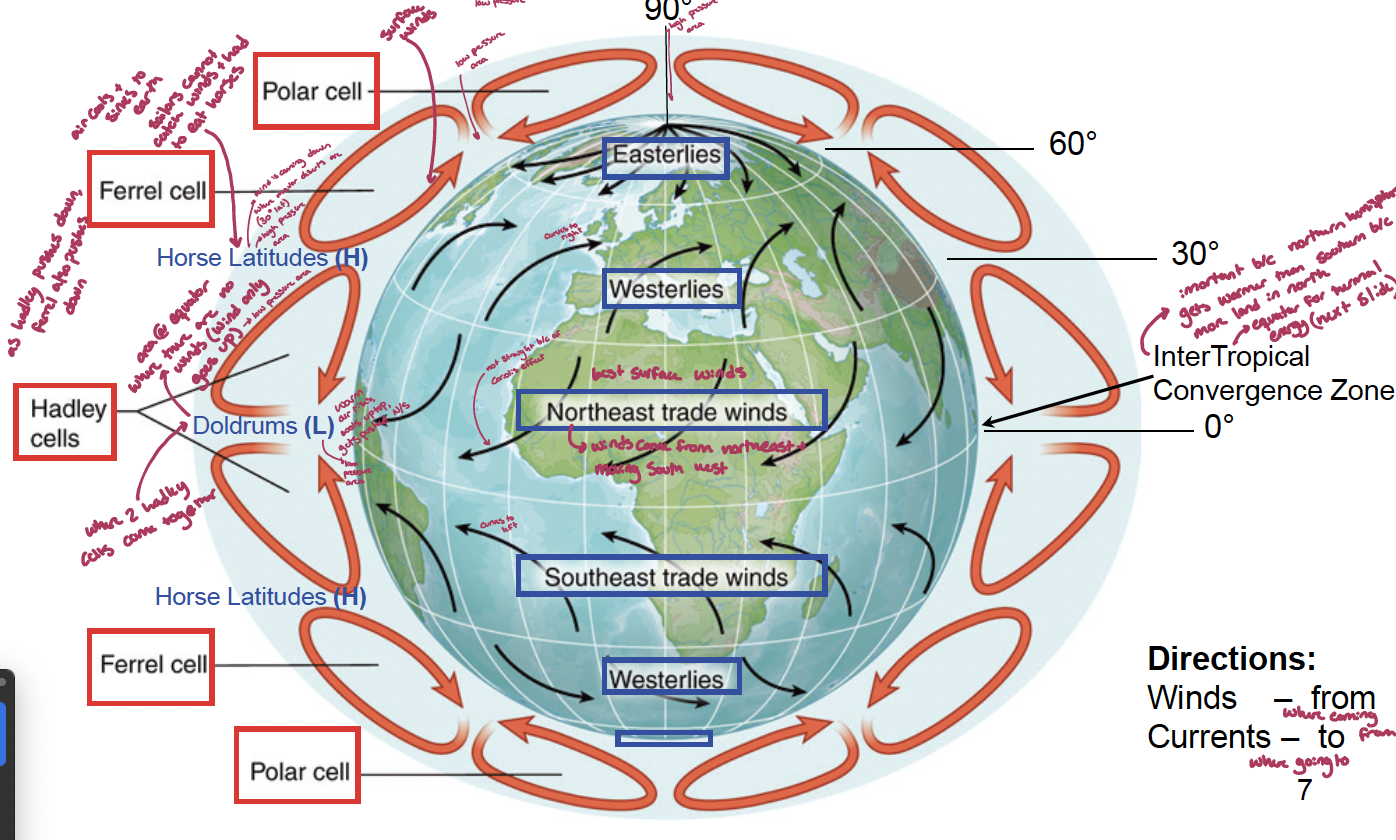
what winds are the best surface winds?
the northeast trade winds
winds coming from the northeast moving southwest. they are the strongest because there are closest to the intertropical convergence zone and the northern hemisphere which gets warmer than the southern hemisphere because there is more land north of the eater for thermal energy
what is the difference in the meteorological (thermal) equator and the geographic equator?
The intertropical convergence zone changes seasonally with the thermal equator. this ships the thermal equator around 5° north in the Sumer and stays around 0° in the winder. surface winds, atmospheric pressures, rains, and monsoons also shift seasonally
changes in low pressure areas leads to changes in wind direction which can lead to monsoons
what is ekman transport?
caused by the coriolis effect, as winds push against the surface of a large body of water, shear force causes each layer of water to drag the layer below, leading to a spiral called ekman transport.
although theoretically the mean direction and flow of the water would be 90°, at the surface it is only 45° due to friction of the water
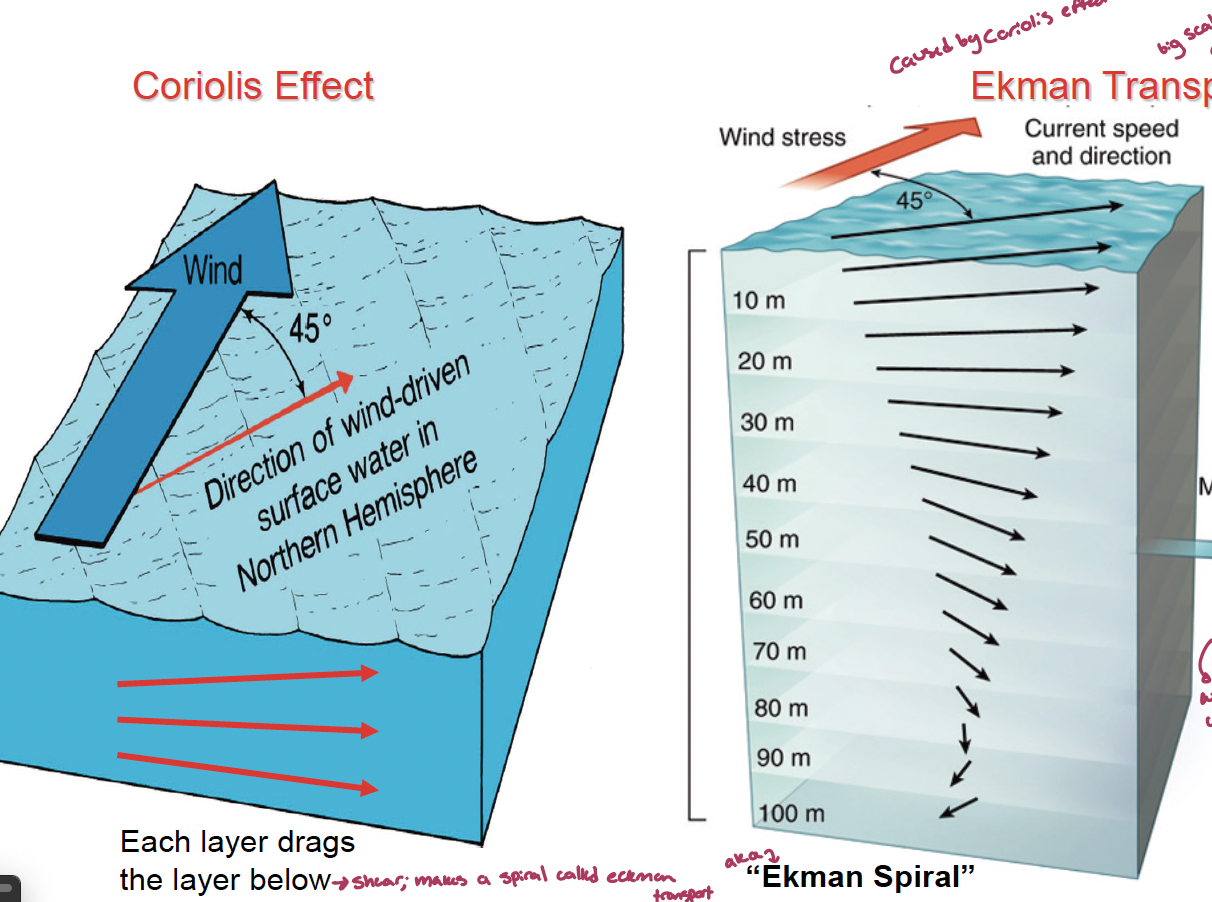
what causes surface currents? what does it make?
surface currents are driven by winds that blow around the periphery of ocean basins (ekman transport, 45°) leading to gyres that distribute heat from the equator to the poles
waver moves away from the equator as the energy moves from surplus to deficit, making a current that moves to the right in the northern hemisphere and left in the southern hemisphere
what are the major geostrophic gyres (5)? the circumpolar one? what are the currents of the North Atlantic gyre (4)?
geostrophic
north Atlantic gyre
Gulf Stream: moves away from the equator; major current that brings warm water from the equator up)
north atlantic current: moves across the ocean basin; moves warm water towards europe
canary current: moves across the coast of Africa; cooler water
north equitorial current: runs along the equator; powerful current where most hurricanes and tropical storms form
North Pacific gyre
South Pacific gyre
South Atlantic gure
South Indian gyre
circumpolar
west wind drift (antarctic circumpolar) gyre: blows all he way around the antarctic - very different from the others
what forces work to form a gyre?
gyres in the ocean have two forces working on them
coriolis effect: causes water to form a hill in the center of a gyre
gravity (pressure gradient): acts against the hill pushing water down (downwelling) under it.
what are the major oceanic current that each gyre has?
western boundary: brings warm water away from the equator (Gulf Stream)
eastern boundary: brings cool water back to the equator (canary current)
transverse: traverses the ocean (Does not run along a landmass), equitorial currents. there is a west and east transverse
countercurrents and undercurrents: current goes against another current (one equitorial current against another)
what is the difference in the flow of the Gulf Stream and the canary currents? what does this tell you about western and eastern currents?
Gulf Stream: velocity is 2-2.5 m/s, around 450 m deep and 70 km wide, leading to a discharge values of around 55,000,000 m3/s (55 Svedrup)
canary current: velocity is 0.35-0.5 m/s, around 1000 km wide and shallow, leading to less flows (16sv)
western boundary currents are all stronger than easter boundary currents
what is different about the wast wind drift?
it is only an east transverse current because it is not a geostrophic gyre (affected by gravity and coriolis) but a trransverse gyre caused by wind only, it is the biggest eastern current with a high flow of around 100sv
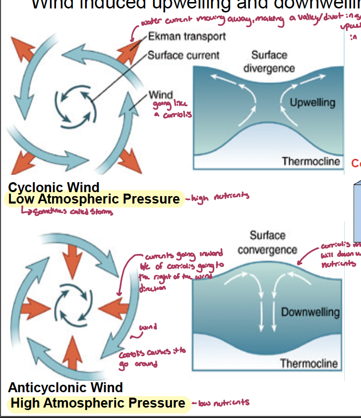
water moves away from the continent because of wind blowing north east is south, to stop a valley from being formed, water fills the “hole” though upwelling of water (bringing nutrients up, photosythetic things love it and thrive)
what is upwelling and down welling? what does it mean for nutrients? what is each of the following associated with:
surface divergence
surface convergence
winds → coast
wind ← coast
north winds in the northern hemisphere
south winds in the northern hemisphere
offshore currents
onshore currents
upwelling: caused by cyclotomic wind and low atmospheric pressure. water current moves way from the wind, making a valley/divot in the surface, upwelling fills that in and is an area of high nutrients
associated with surface divergence which makes a divot
when winds blow straight away from the coast it leads to upwelling
north winds (going south) blow parallel to the coast, coriolis makes the currents move to the right, causing a divot and leading to upwelling
offshore currents
downwelling: caused by anticyclonic winds and high atmospheric pressure, currents go inward because of the coriolis effect going to the right of the wind direction. coriolis makes a hill, water will downhill, leading to low nutrient areas
associated with surface convergence which makes a hill
when wind blow straight toward the coast it leads to downwelling
south winds (going north) blow parallel to the coast, coriolis makes currents move to the right, creating a hill, leading to downwelling
onshore currents
what is thermohaline circulation?
it is driven by differences in density caused by water masses or different density created by combination of themerature and slainity
Dense (cold/saline) surface water enters the bottom water from the poles; warm water upwells near the equator (~ 1 cm/s → stronger thermocline) over 1000s of years
Thermohaline circulation below the pycnocline represents 90% of the water movement in the ocean.
this is the atlantic meridonal (crossing latitude) overturning circulation (makes a surface) (AMOC)
what are the five waters in the ocean from top to bottom? the other one?
surface waters: above 200 m
central waters: 200 m - thermocline
—abyssal waters— (in bathopelagic zone)
intermediate waters: 700-1500 m
deep waters: 1500-4000 m
bottom waters: contact with the sea floor
mode waters: tick, breeding direibutedm lear surface layer; homogenous vertical and horizontal
lecture 15
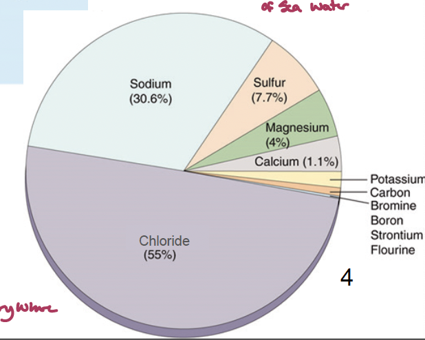
what is the ocean comprised of?
96% water, 4% salty. it is composed of many ions with sodium and chloride being the biggest ones that come from both the crust and the mantle (through volcanoes and stuff)
what is the distribution of salinity in the ocean? how does salinity affect the physical properties of water (4)?
salinity can vary because water varies due to precipitation and evaporation.
increased salinity leads to:
a lower heat capacity (how much range occurs with heat - water is very high, salt reduces it),
lower freezing point
lower evaporation
higher osmotic pressure
what kinds of elements are the constituents of seawater (2)? what are the two properties they can be
14 major elements (over 0.001%)
40 trace elements (less than 0.001%)
some are conservative, do not change much with respect to where they are found, have a long tres
some are non-conservative, biologically active, not similar everywhere, have a short tres
what is the principal of constant properties?
the properties of sea water is constant even with changes in salinity (dynamic equilibrium)
what is the redfeild ratio in the ocean? what is most limiting?
C:N:P = 106:16:1
nitrogen is more limiting in the surface ocean that phosphorus
where are oxygen minimus zones?
anoxic zones in (west) coastal upwelling areas. below the oxygen compensation depth (oxygen = carbon dioxide). this is due to being below the picnocline there is no mixing. as you go down further oxygen gets greater because there is not as many microbes and not as much detritus to use it
how does ocean acidification happen? What are the biogeochemical consequences of these changes
uptake of CO2 from the atmosphere. the ocean is responsible for 30-40% of anthropogenic CO2 uptake as it enters oceans and other aquatic systems. increased CO2 levels has led to a decrease of 0.12 pH, equivalent to a 30% increase in concentrations of hydrogen ions in the ocean.
pH is proportional to calcium carbonate saturation. a Lower pH leads to dissolving of calcium carbonate shells
what is the biological pump? what does that mean for the distribution of productivity?
the conversion of CO2 & inorganic nutrients in the euphotic zone (epipelagic) into POM transferred to the deep ocean (goes into the silicate carbonate cycle)
the distribution of productivity reflects the nutrient availability (physics) in different ocean regions. this is controlled by PAR, temperature, mixing (of nutrients), and grazing
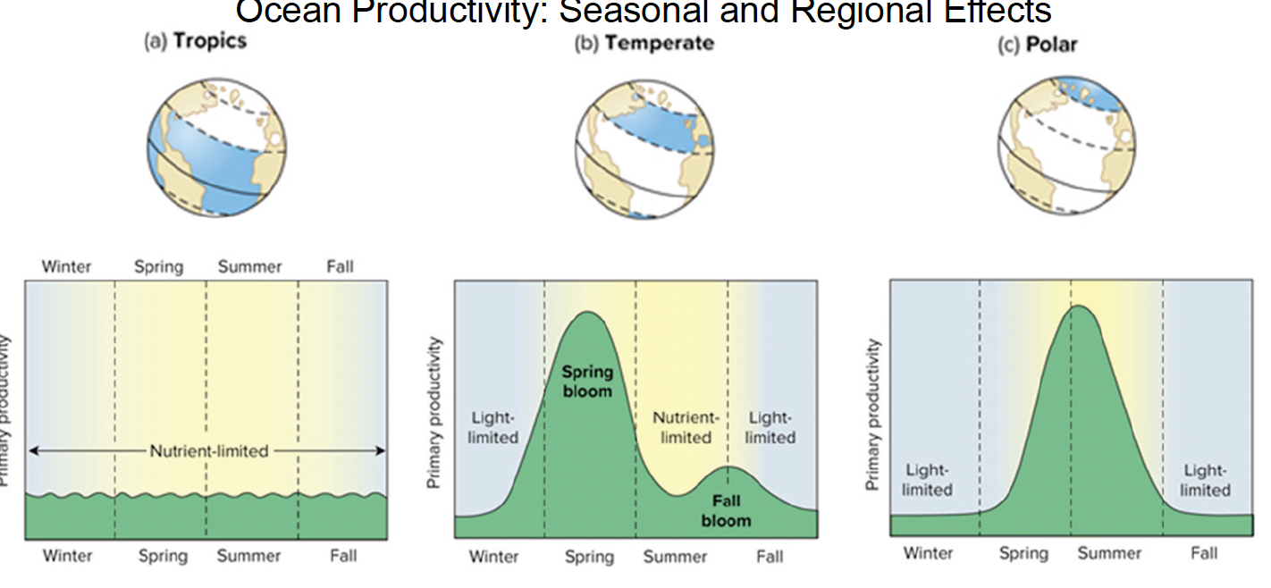
what are the seasonal and regional effects on ocean productivity?
tropics: relativley similar levels throughout seasons, all being nutrient limiting
Picoplankton: Unicellular cyanobacteri (Prochlorococcus, Synechococcus)
Nanoplankton: Coccolithophorids
Net Plankton: Colonial cyanobacteria (Trichodesmium Dinoflagellates)
temperate: the winter and fall are light-limiting whereas the spring has a spring bloom and the summer is nutrient limiting
Picoplankton: Unicellular cyanobacteria (Prochlorococcus, Synechococcus)
Nanoplankton: Cryptophytes
Net Plankton: Diatoms
polar: winter and fall are light limited while a large bloom is seen in the spring and summer
Picoplankton: Unicellular cyanobacteria (Prochlorococcus, Synechococcus)
Nanoplankton: Cryptophytes
Net Plankton: Diatoms
what is the phytoplankton diversity and distribution in the ocean (5)?
cyanobacteria: small unicellular cyanobacteria are abundant in the pelagic surface waters while larger and colonial cyanobacteria are abundant in coral reefs
coccolithophorids: small size, have calcium carbonate plants; they are found in nutrient poor waters
diatoms: very important primary produces (efficient), they are found solo and in colonies. they are common in all waters but tend to be more important in cold waters
dinoflagellates: unique shapes with 2 flagella and cellulose plates. some are bioluminescent, other form HABS (ie. red tides)
silicoflagellate: star shaped with two unequal flagella
what is the zooplankton diversity (8)?
plankton - two major types; they have patchy distribution and use dial vertical migration
meroplankton: live part of their lives as plankton then become free swimming or bottom dwelling
holoplankton: live their whole lives as free floating plankton
Foraminifera: CaCO3 shelled ‘amoeba’; they have filaments to trap food.
Copepods (small crustaceans): dominant taxon ~70% of zooplankton. they are both Grazers & zooplanktivores.
Krill (Euphasiids; large crustaceans): important grazers especially in the Antarctic (6 cm, 5-year life span); largest = nekton.
Salps & larvaceans (pelagic tunicates): use mucous house or nets to capture food particles; salps can be colonial.
Pteropods (pelagic gastropods): grazers of phytoplankton and zooplanktivores (most abundant in upper 200 m).
Chaetognaths (arrow worm): fish-like zooplanktivores.
Jellyfish & Comb Jellies: carnivores, can be large but slow. Some may float to feed on neuston.
what is the Nekton diversity (6)?
Some characteristics: fast swimming (streamlined), protective coloration (countershading, camouflage, transparency), a variety of sense organs (eyes, lateral lines), bioluminescence at depth
Cephalopoda: jet propulsion
Fishes: ~ 30,000 marine species
Chondrichthyes: sharks/rays
Osteichthyes: bony fish
Chelonioidea: 7 extant species
Aves: Albatross, Petrels, Puffins, Penguins,
Carnivora: eared seals
Cetaceans:
Odontoceti: toothed
Mysticeti: baleen
what does the pelagic food web look like?
the Open Ocean is oligotrophic with DOM and picoplankton (e.g., Synechococcus), grazed by microzooplankton (e.g., ciliates), consumed by mesozooplankton, and then by small zooplankton (e.g., copepods), and then by large zooplankton. These are eaten by fish, which are eaten by larger fish, birds, and/or whales, and perhaps a top carnivore.
Polar & upwelling areas are mesotrophic and have nutrients that support larger algae (e.g., diatoms) with fast growing large herbivores (e.g., Clupleids, krill), that are consumed by high abundance and variety of predators (e.g., fish, seals, birds, whales).
what does the epipelagic food web look like?
Phytoplankton are the base of the food web.
Herbivorous mollusc and barnacle larvae, small and large herbivorous copepods, krill, and larvaceans feed on phytoplankton. Jellyfish, comb jellies, arrow worms, sand eels, amphipods, and adult herring feed on the herbivores.
Young herring (7 - 42 mm) feed on jellyfish, comb jelly, and arrow worm larvae.
what are the oceanic food web predators?
the Pelagic food web involves small and smaller scale grazing and predatory interactions in the epipelagic zone.
Larger aerial and aquatic predators (e.g., mola mola, sharks, porpoise) cruise in the region. Some of these predators continue down to the mesopelagic zone (1000 m).
Surface water predators are replaced by specialized deep-sea predators (e.g., anglerfish, lanternfish, sabretooth fish) in the bathypelagic (4000 m) & abyssopelagic (6000 m), and are more limited
lecture 16: waves and tides
what is the equilibrium (newton) theory of tides? what is the barycenter?
forces cause tides
the source of gravity from the moon and the sun (pulling together)
inertia force from the earth rotating around the sun and the moon rotating around the earth (pushing apart)
the bulges in line with the moon causes 2 high tides while depressions at right angles to the moon causes low tides. tides are 50 minutes later each day
barycenter: the center of rotation between the earth and the moon. it is nor in the center of the earth because the earth is larger than the moon
what is the difference in solar and lunar tides?
when the moon and sun are aligned, they are either pulling in the exact same direction or exact opposite direction, leading to the largest tidal differences (lowest low tides, highest high tides). these are called spring tides and occur at full (low tides) and new (high tide) moons
when the moon and sun are at a right angle to one another, there is the smallest tidal differences (smallest high tides, largest low tides). these are called neap tides and occur at ¼ and ¾ moons
the sun is much larger than the moon in mass but it is also much smaller away, leading to the moon tides being 54% stronger than the sun tides (the sun only has 46% of the effect that the moon has)
why are tides 50 minutes later each day? what are the other two factors that influence the movement of the tides?
because the rotation of the earth (24 hr cycle) is not equal to the moons orbit (24hr 50 min cycle)
moon decimation varies +- 28.8° north/south during lunar month (bulge moves n/s depending on the moons position
Tides are shallow-water waves (feel and are affected by the bottom of the basin), which means that they are affect by the shape and depth of the ocean basins and are refracted (bends as it moves), reflected, and altered by the Coriolis effect. there are three kinds of tides. there is no geographic pattern to these tides:
semidiurnal: two tides a day
mixed semidiurnal: two tides a day but with different heights
diurnal: one tide a day
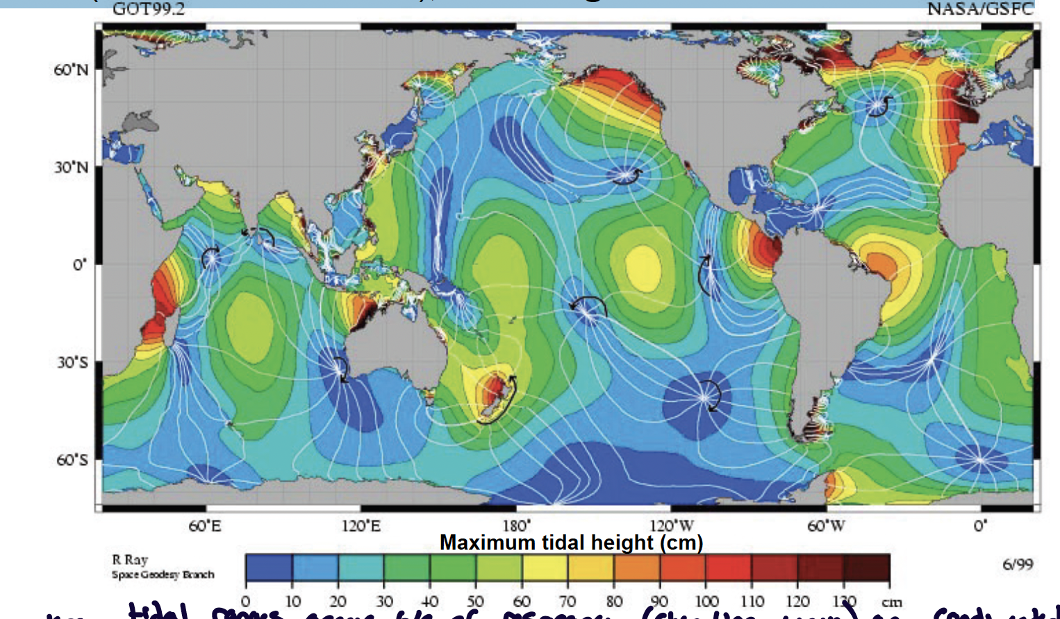
what are amphidromic points?
places where there are no tides, nodes (no tide) out of which radiate cotidal lines (location of tidal crest); tidal range increases from the nodes.
large tidal ranges occur because of resonance (standing wave) in constricted regions (ie. 16 m tidal range in bay of fundy)
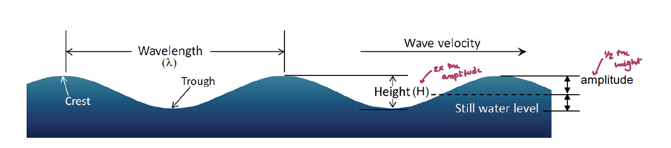
what are waves? what are the characteristic structures and patterns of them (4)?
Waves are periodic disturbances in the surface of the ocean created by wind, gravity, or other displacements of water (earthquakes).
The waves are the transfer of energy through the water (NOT the movement of water) that are manifest at the interface of fluids of different density (i.e., surface waves or internal waves).
Waves have characteristic structures and patterns of travel: wave height is 2x the amplitude
(λ) Wave period (T) = time for a wave to travel past a point (complete one cycle)
Wave frequency (f = 1/T) = number of waves that pass a point per second
Wave speed (v = λ/t) = distance a wave travels past a point per second - for waves not affected by the bottom
Wave steepness = H/λ if H/λ is greater than 1/7, then the waver will break (white cap)
what are wave orbits?
Waters moves in circular orbits (since water does not technically move with the wave, instead they make circles) as the energy passes through the water, but there is no net movement of water in the direction of the wave.
Orbits transfer energy horizontally but decline in size vertically because of shear in the water column
Orbits become negligible in size at a depth, D ~1/2λ (wave base)
Deep-Water Waves (deeper than λ/2) do not feel the bottom. All ocean wind waves but not tides (λ ~ 200,000 km) or tsunamis (λ~1000 km) seismic activity
The speed of deep-water waves is, v = λ/T
simplifies to, v = 1.25 √λ
Wave speed depends on the wavelength (longer waves are faster)
how does wind effect waves? what re the other things that can affect waves?
Wind blowing (disturbance) causes capillary waves (λ < 1.73 cm) or ripples and then wind waves as the wind continues. The former are restored by capillary action vs. gravity, which restores all other wave types.
(1) Wind speed, (2) duration and (3) fetch (longest straight line distance across a water basin) all generate waves of all sizes which can co-occur, leading to the need for a statistical description:
Waves of similar λ can coalesce into ocean swell far from a storm center (there the disturbance occurs)
Waves can interact leading to smaller (destructive interference) or larger (constructive interference) waves; H >2Hs are rouge waves (height is greater than 2 times normal wave height)
the largest waves typically occur in the southern ocean in the west wind drift (high wind speed → large H)
what are waves in shallow water like? what are they affected by?
Waves feel the bottom when depth, is less than 1/2λ; They become Shallow water waves when D is less than λ/20, and orbits beomce elliptical and oscillatory
The speed of shallow-water waves is: v = √(gD) or v = 3.1√D (froude’s number, ripples and water jump on the bottom)
Wave speed depends on the depth (waves are smaller in shallow depth)
Wave shoaling: occurs in shallow water because ↓v and consequently, waves become shorter (↓λ), steeper & break (H/λ > 1/7) in the surf zone
Waves can also reflect and refract (bend) in shallow water and modify coastal zones by changing patterns or region (eroding headlands) and deposition (forming beaches)
what is the importance of tides and waves?
Tides:
provide regular disturbances & currents (flooding & drying) that increases spatial & temporal heterogeneity, leading to increased biodiversity.
Tidal habitats (intertidal zone), salt marshes/mangroves, estuaries
Lunar periodicity provide a multiple day (14 d, 28 d) clock Infradian rhythms (>24 hr), spawning & breeding cycles
Large-scale nutrient movement via upwelling/downwelling currents generate disturbances, which can reset competitive outcomes
Waves:
Shoreline development: erosion, transport & deposition of sediment generates local mixing that can affect nutrient uptake, reproduction and dispersal, and removal of wastes generate local disturbance, which leads to patchiness
May provide refuge from predators
what are costal oceans? what are the zones associated and where are they found?
Coastal oceans differ primarily in water depth and in proximity to land compared to open oceans.
Neritic zones as well as the epipelagic zones to a depth of ~200 m.
Water depth provides opportunities for photosynthetically based benthic communities in addition to the settlement of allochthonous production from above in the form of detritus or opportunistic predation.
Nutrients are not always lost to the deep sea but may be resuspended from the bottom by storm activity.
Proximity to land provides land-based subsidies.
Active and more complex hydrodynamics (waves/tides) and chemistry.
These include nutrients (and sediments) both directly in rivers and run off as well as indirectly via coastal upwelling and trophic interactions.
Trophic interactions involving terrestrial, aerial and marine organisms.
Spatial heterogeneity and habitats leading to increased biodiversity.
Limited in area but most productive, diverse, and important to society
how do costal oceans differ in latitude
Low latitude coastal regions have plenty of light but are considered nutrient poor waters, however they can be diverse and productive in:
coral reef ecosystems; hard substrate - biogenic (hard)
seagrass ecosystems; soft substrates - biogenic (soft)
mangrove ecosystems; soft substrates - biogenic (hard)
Mid-latitude coastal regions are subject to seasonal patterns because they are light limited seasonally, can be nutrient limited because of stratification, and/or are controlled by zooplankton grazing. Also contain:
kelp ecosystems: hard substrates - biogenic (soft)
seagrass ecosystems: soft substrates - biogenic (soft)
Salt marsh ecosystems: soft substrates - giogenic (soft)
High-latitude coastal regions are light limited but are nutrient rich because the region is cold and isothermal (seagrass ≤ 76°N; salt marsh ≤ 70°N)
what does the metric ecosystem look like?
Benthic (bottom associated) ecosystems are diverse with greater than 200,000 species of which ~80% are epifauna (living on the bottom) and~20% are infauna (living in soft sediment). Some experience full tidal range in intertidal zone (H-L tide) while others live in subtidal zone (always submerged).
many are bipartite with planktonic larvase (less meroplankton)
The distribution of benthos is controlled by complex interactions of physiological and ecological factors, but the patterns of benthic biomass closely match surface primary production
what are coral reefs
Modern coral reefs are formed by stony corals (Anthozoa: Scleractinia), which are hermatypic (reef building). Many organisms contribute to the reef; deep-sea corals do not create reefs.
They live in shallow, warm, clear, and nutrient poor waters and are symbiotic with zooxanthellae (dinoflagellates).
aragonite (CaCO3 ) corallite skeleton, that grows atop previous corallites leading to increased growth; growth can also occur by budding. (what you see without the zooxanthellae)
they occupy <1% of the ocean, but support 25% of marine organisms and protect shorelines, contribute to beaches ect.
tight coupling in a low nutrient environment, creating an ecosystem)
what is different about deep sea coral reefs?
deep sea corals do not make coral reefs, still capture particles in the water and consuming them as heterotrophs but do not have the symbiosis with the dinoflagellates
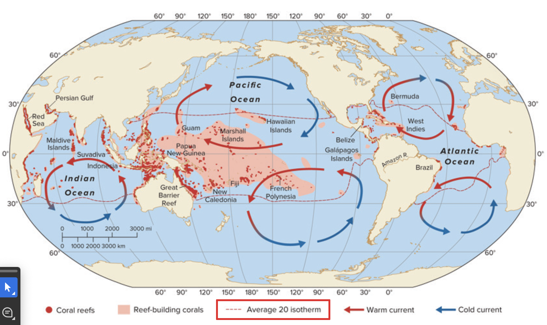
where are coral reefs found?
Coral reefs are found where the average water temperature is > 20° C
not just latitude, but looking at where the western boundary curves are bringing in warmer water
not a lot of corals on the western side of south america because there is upwelling cold water that is cold enough that the corals do not like to live there. also the amazon river brings in a lot of sediments, making the water near the shore more turbid
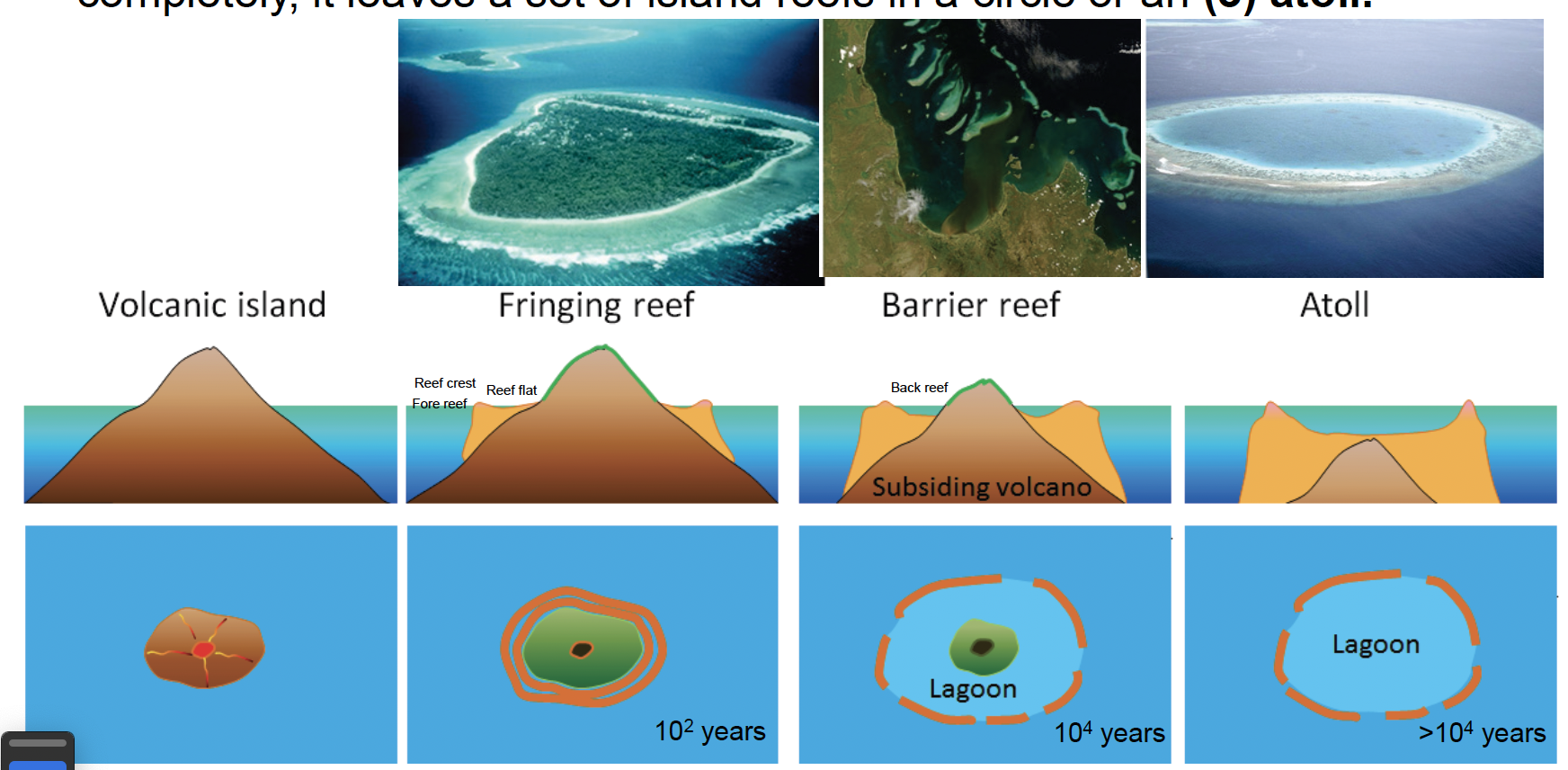
how do coral reefs form?
Coral reefs form at shallow depths around landforms including continents and volcanic islands. They begin as fringing reefs close to shore. As the land subsides, a deep lagoon forms next to the land leading to barrier reefs. When the volcano at the center of the barrier reef erodes completely, it leaves a set of island reefs in a circle or an (3) atoll. may take a couple of hundreds of years to occur
volcanic island comes up, cools, coral larva can colonize, the shallow water surrounding the island has a fringe of corals (fringing reef). during glaciation events, the sea level fell and the land would be able to be eroded by rain, forming a deep lagoon leading to the coral dying and when the coral recolonize a barrier reef is formed. then there is an area in the lagoon that is completely protected from waves (the back reef). a ring forms and creates an atoll
how do coral reproduce?
Most corals are broadcast spawners in which their gametes are buoyant forming slicks on the water surface.
Spawning usually occurs in relation to the lunar cycle, i.e., near full moon, once per year.
Synchronous mass spawning events occur in the Great Barrier Reef (couple of days where is occurs everywhere) vs. asynchronous spawning species that occur in the Red Sea, Caribbean, central Pacific, Hawaii (different species spawn at different times).
embryonic development occurring in the water column leading to a planula larva stage, which seeks out appropriate bottom hard substrate to settle
what does the diversity of corals look like? what are the four types of morphology?
There are several characteristic grow forms in hermatypic corals that are associated with different locations (physical conditions) on the reef. there are around 850 reef building coral species
there is a relationship between the morphology and where it occurs in the reef
the names of those morphologies corals are:
Encrusting (grow over thing): very exposed areas (reef crest- where the waves were crashing over everything)
Branching: wave exposed areas (fore-reef slope) - a little deeper water than encrusting corals
Massive & Columnar: in moderately exposed areas (reef flat- still exposed to waves, but less strong than the reef crest) - ie. brain coral
Foliaceous, Plate-like, Free-living: in sheltered areas (back reef slope (lagoon areas) - calm water) - more sediment depision in those areas
Many other organisms contribute to the creation/maintenance of coral reefs through the binding (sponges, urochordates) and cementing (articulated chlorophytes, encrusting rhodophytes) of corals and coral rubble - without these linking elements, you would not have a coral reef, you would just have coral
what does the food web in a coral reef look like?
1° Production is occurring from zooxanthellae, macroalgae, and N fixing cyanobacteria; nutrients are tightly bound; allochthonous material from mangroves & seagrass.
Corals are also heterotroph via (1) capture zooplankton using nematocysts (sting their prey) on their tentacles, and use (2) mucous sheets (catch any material that falls down into them) or (3) mesenterial filaments from the gut wall to capture zooplankton and particles externally - by stinging them, also used to fight each other by burning each other.
Conceptual Food Web: 16 key functional groups
Reasonably short food chain length because it is reasonable contained
what environmental impacts can coral reefs have (5)?
Corals have a narrow range of tolerance of temp, salinity, pH, PAR (photosynthetic radiation), substrate, nutrients, macroalgal growth, etc.
Temperature (global change): temp changes greater than 30° C have lead to corals expelling the zooxanthellae, leading to coral bleaching - seeing the limestone underneath
Sediments (development): increases turbidity, leading to reduced photosynthesis
burial of polyps, leading to interruption of feeding
Pollution/disease (human activity): when nutrients are added to the system, macroalgal (usually nutrient restricted) bloom and outcompete the corals (Alternate Stable State)
freshwater brought in from Hurricanes, leads to the death of polyps
chemical (ie. sunscreen) can lead to bleaching and growth defects and deformation
disease (ie. white band disease: elk horn, comes from human sewage) increases pathogens
Fishing & Aquarium trade: Destructive practices (dynamite, cyanide, trawling,
muro-ami netting (get people with rock on ropes and bang to scare fish into an area in a net) rbreaks the coralsAcanthaster planci (crown of thorns Seastar): outbreaks of them decimate coral reefs; the response was to grab and collect them and kill them, they cut them in half and they regenerated and increased the problem
lecture 18: marcophyte canopies
what are marine macrophytes?
Marine macrophytes are macroscopic primary producers that are mostly benthic in habitat. They form important ecosystems through the complex 3-dimensional environments “canopies” formed by their
presence. rich 3d habitats that are not there without the macrophytes
Marine macrophytes are found on (1) hard substrates (mostly macroalgae/seaweeds) where they attach to the substratum and in (2) soft sediments (mostly plants) where their roots and rhizomes grow under the sediment surface.
marine macrophytes are diverse and include photosynthetic protists (macroalgae) and plants (seagrasses, mangrove plants, and salt march plants)
They are found in shallow, clear, nutrient containing coastal waters to sustain photosynthesis – i.e., primary productivity.
They are among the most productive ecosystems on the planet, are limited spatially, and are vulnerable to environmental stressors and
human activities (since the 1980s: 30% loss of seagrass, 35% loss of mangroves, and 50 -70% loss in kelp).
what are the three major macrophyte algal phyla? how do macroalgae exist in the ocean? where are they found?
Three major algal phyla produce macroalgae (or seaweeds) including:
Chlorophyta (e.g., Ulva - green algae)
Rhodophyta (e.g., Porphyra nori(what wraps sushi) - red algae)
Phaeophyta (e.g., kelp).
Most macroalgae attach to hard substrates on the bottom; detachment results in mortality. They are found in subtidal and intertidal zones.
may superficially resemble plants convergently, many are calcareous. (evolved it separately from the terrestrial plant features; calcium carbonate in their tissues can restrict who can graze you and withstand waves)
Holdfast anchors macroalgae to the bottom, stipe is the stem-like portion on which fronds (blades) attach; there may be a pneumatocyst (floats that help the plant to float to the surface in order to get to the light)
macrophages provide food and shelter for other organisms
what are the vertical rocky intertidal zones and what re the stresses pit on macroalgae in each zone (5)?
Supratidal: dry and extremes in temperature and salinity
not affected by tides except for with wave splashes
Upper Intertidal: Physiological stress desiccation, wave, etc. experience arial, terrestrial, and marine predation
Mid intertidal: physiological & ecological stress
competition for space, gets stringer as you get deeper
exampels: fucus (rock weed, makes a kinda that is crunchy because it has spongy areas on top that help them float That can dry out)
Lower intertidal: Ecological interactions competition, predation
example: ulva (green algae, sea lettuce)
Subtidal: ecological interactions. every year there is a kind tide when the sun and earth are the closest, it is the only time whenever this area can be exposed
examples: nereocystis (sea motion at low tide has a pnematocyst that floats on top of the water), porphyra (sushi), gelidium (red algae)
Vertical zonation is characteristic of the intertidal with distinct Fucus layer in mid-intertidal. the bulk of macroalgal density us subtotal (underwater)
what are kelp beds? where are they found and what do they do?
Kelp (Phaeophyta) beds are found in cool temperature/polar waters (high latitudes, lower in eastern boundary currents) in the subtidal. They are vulnerable to heating (El Niño; marine heat waves, climate change)
El Niño happen due to the high pressure of South America and low pressure of Indonesia causing the water at the coast of South America to upwell. this stimulates growth and is a good time to fish but the warming of the water kills the kelps ☹
they are very productive, providing food and habitats to invertebrates and fish in the 3 dimensional habitats formed in their canopy and understory.
sea urchins will eat the holdfast of kelps, ultimately killing them
when waves hits th elp, eater movement is broken down and slowed
what are seagrass beds? why are they important?
Seagrasses (monocots) are ~60 sp. of submerged flowering plants (make underwater flower - pollinated by water flow. there is some evidence of pollination via zooplankton) with blade-like leaves that form beds in soft sediments (1 genus on rocks) in intertidal & subtidal regions in tropics, temperate & polar regions.
Can achieve high biomass leading to high primary production + habitat.
seagrass beds help stabilize sediments (keeps sediments soft) and react and maintain infernal habitats
what are mangrove and salt mashes? why are they important?
Tidal ecosystems created by halophytic plants (some with salt glands), which are at the interface of aerial, terrestrial & marine/freshwater systems (a lot of salt marshes are at the end of creeks). they serve as important nurseries and habitat for organisms from each region. they protect coastlines from storms including tropical cyclones by slowing the waves.
mangroves (manuals): most often found in tropical regions; ~80 species of trees (Red, Black, White(white have taproots)) that can only be partially submerged (not freeze tolerant). Zonation of tidal tolerant sp. with prop roots (stick up and get air at low tides) and pneumatophores. often linked to seagrass and coral reefs
salt marshes: often found in Temperate Regions; Various sp: Spartina (Atlantic), Carex (Pacific) along with other graminoid (grass-like) sp. Zonation of tolerance to different tidal ranges. Limited number of herbivores (urchins, fish), mostly to detrital food webs. often linked to seagrass beds.
on the east coast, salt marshes are mainly grasses,
on the west coast, mainly sedges
salt marshes colonize slow (years) while mangroves conolizee fast (weeks)
what are the interactions among mangroves, seagrasses and coral reefs?
Mangroves, Seagrasses, and Coral reefs buffer inland habitats from storms and wave damage. they also exchange mobile fish & invertebrates leading to biogeochemical and trophic exchanges.
Mangroves and Seagrasses are critical in regulating sediment, freshwater, and nutrient flows to coral reefs where they would be detrimental.
Mangroves and Seagrasses serve as nurseries for coral reef fish
Seagrasses and Coral reefs protect from wave action
know these macrophytes:
example questions
What does an oceanic basin look like in profile?
an oceanic basin can be split up into different areas based on the relation to continents and the surface features.
the continental margin, made up of:
continental shelf: shallow submerged edges of the continent
shelf break: the slope increases significantly at the shelf break
continental slope: the steeply sloping region past the continental shelf
continental rise: after the continental slope, it is a more gentle change in slope that is filled with deposited sediments
abyssal plains: flat, featureless regions covered by sediment less than 1 km thick, typically at depths of 3700-5500
abyssal hills and seamounts
oceanic ridge and rises: a mountainous chain around 2 km high and 65,000 km long, marking a sea floor spreading center (divergence zone). a rift Vally is typically preset along the mid-oceanic ridge
oceanic trenches: deep depressions often found ear active continental margins
What are hydrogenous sediments?
sediments that came out of solutions (ie. manganese nodules)
often found in mid-ocean ridges and areas starved of other types in both neritic and pelagic zones
What drives a convection cell? Give an example
the property of air where warm air is less dense than cold air, and because of this it expands and rises. because air moves from energy surplus to energy deficit, the air will move in a loop, creating a convection current
example: a room with a radiator and a window without insulation in the winter. the warm air released from the radiator will rise to the ceiling and move in a direction of energy surplus to energy deficit (the cold window). that cold window will cool the air and lead it to sink and run along the floor back to the radiator
Explain what is meant by a geostropic gyre?
a gyre that has two forces working on it:
corriolis
gravity (pressure gradient)
Why are Western Boundary Currents larger than Eastern Boundary Currents?
because of western intensification. since western currents carry water from the equator (energy surplus) they are much stronger than eastern boundary currents who are carrying the water from western boundary currents that has now cooled and lost energy
What are effects do the sun and the moon have on tides?
the sun and moon both affect the tide, with the moon having a stronger effect (around 54% stronger). the forces of gravity (pulling force) and inertia (pushing force) from both the sun and the moon cause the tides
the positioning of the moon and sun relative to one another changes the heights and strengths of the tides. when the sun an moon are aligned (the spring tides) they cause the lowest low tides (the full moon) and the highest high tides (new moon)
if they are at a right angle to one another, there forces appose one another, leading to the smallest high tides and largest low tides (neap tides: ¼ + ¾ moons)
Describe the vertical distribution of conservative and non-conservative elements in the oceans? What causes these distributions?
conservative elements in the ocean do not change much and have long residence times in the ocean. their distribution is relatively uniform across the different layers of the ocean.
this is because these elements are not actively utilized or significantly affected by biological processes or chemical reactions. since they have a long residence time, they can be thoroughly mixed throughout the ocean by large scale circulation patterns (ie. thermohaline circulation)
non-conservative elements vary in concentrations with regards to depth. they have a short residence time
this is because non-conservative elements are biologically active, meaning that they are affected by biological processes and chemical reactions. things like CaCO3 have compensation depths due to them being broken down at certain depths
How are corals involved in biogeochemistry?
corals (particularly hernatypic corals) are involved in biogeochemistry through their role in primary production within nutrient poor waters. corals form symbiotic relationships with zooxanthellae living in their aragonite corallite skeleton. the carbonate material is a form of biogenies sediment.
corals tend to live in nutrient poor areas (ie. low-latitudes). the zooxanthellae allow the coral reef ecosystem to sustain itself, with this symbiosis being the primary corse of net primary productivity for the ecosystem
How does upwelling occur and why is it important in aquatic environments?
many things can influence upwelling. upwelling occurs due to cyclonic wind and low atmospheric pressure. water current moves way from the wind due to the coriolis effect, making a valley/divot in the surface, upwelling fills that in and is an area of high nutrients
associated with surface divergence which makes a divot
when winds blow straight away from the coast it leads to upwelling
north winds (going south) blow parallel to the coast, coriolis makes the currents move to the right, causing a divot and leading to upwelling
offshore currents
What is the difference between seas and swell?
seas (wind waves): waves generated bu the wind blowing over the ocean surface, causing a disturbance making capillary waves
swell: waves that have coalesced from waves of similar wave lengths. they do not abide by the sizes of locally generated waves. if big enough they can be classified as rouge waves
What is the speed of a 20 m long wave in 1 m of water?
shallow water wave equation: v = 3.1√D
v = 3.1√20
v = 13.9 m/s
How do fringing reefs differ from barrier reefs?
fringing reefs are formed before barrier reefs. they are newer and form closer to share.
barrier reefs are formed when the land around a fringing reef subsides due to glaciation events where the sea level fell, allowing the land to be eroded by rain, killing the corals in the fringing reef and creating a deep lagoon next to the land. the coral then can colonize the deep lagoon, leading to the formation of a barrier reef
What are waves and how are they classified?
waves are periodic disturbances in the surface of the ocean created by gravity, winds, or other displacements of water. they represent the trnasfer of energy through the water.
waves are classified based on water depth relative to their wave length as well as their disturbance force and the resorting force that acts upon them.
force:
capillary waves: tiny ripples with wavelengths of less then 1.73 cm. they are restored through capillary action (surface tension)
gravity waves: all other wave types that are restored by gravity
water depth:
deep water waves (occur where the water depth is greater than half the wavelength. these waves do not feel the ocean bed. their speed is determined v = 1.25√λ
shallow water waves: (occur when depth is less than 1/20 of the wavelength). there speed is terermined by their depth
Abiotic factors are said to affect the ecology of marine organisms, can you provide support for this statement in the intertidal zone?
intertidal zones are a region characterized by physiological and ecological stresses related to its tidal exposure. vertical zonation patterns in this area are a consequence of these stresses
How can arthropods be present in the plankton, nekton, and benthos?
due to species in the phylum having diverse life stages and locomotion strategies that can fit them into the niches seen in each of these types of lifestyles.
Why is zonation evident in many intertidal ecosystems (give examples in your answers)?
there is vertical zonation because of the physiological and ecological stresses that are present in intertidal ecosystems due to the tidal changes. zonation patterns reflect how the constantly changing tidal range (flooding and drying) creates vertical boundaries where different species can survive the unique combination of physical challenges and biological pressures
upper zonation example: higher areas in the surpatidal may only support lichens and algae, followed lower down by periwinkle snails and then rock crabs
mid zonation: this region contains dense macroscopic algae such as fucus and below that barnacles, limpets, and blue mussels
lower zonation: near the low tide level (MLW) ulva and chiton are found