Flooding, the hydrological cycle, hydrographs
1/37
There's no tags or description
Looks like no tags are added yet.
Name | Mastery | Learn | Test | Matching | Spaced | Call with Kai |
|---|
No analytics yet
Send a link to your students to track their progress
38 Terms
How is new infrastructure a human cause of flooding?
Urbanisation leads to the growth of towns and cities.
As the population increases, new roads and shopping centres, etc, are built.
The greater the area covered by buildings and roads (impermeable surfaces), the greater the potential flood risk.
How are new houses a human cause of flooding?
Due to demand, many are built on greenfield sites.
Between 2001 and 2011, there was a 72% increase in the average density of new dwellings in the UK.
There are strict planning controls regarding building on flood plains, however 7% of new dwellings in England in 2011 were built on areas of high flood risk.
Large areas of flood plains are now covered with impermeable tarmac roads and concrete pavements.
Cities therefore have few natural areas to store excess water.
How are disappearing gardens a human cause of flooding?
People pave over gardens to save mowing the lawn.
A direct line survey in 2013 revealed 47% of UK households have 2 cars.
Many households have concreted over their front gardens to accommodate cars due to absences of garages.
How is forestry a human cause of flooding?
Felling trees reduces interception and roots no longer take water from the soil.
The impact of felling could be considerable (a dense forest uses up to 40% of any precipitation).
After felling, soil soon gets saturated run off occurs, river discharge increases quickly, and the risk of flooding increases.
How is farming a human cause of flooding?
Since WW1, hedges have been ripped out to make way for huge fields more efficient for highly mechanised arable (crop) farming.
Loss of hedges mean less interception.
Once crops have been harvested, they leave the soil bare in winter.
This means there's no vegetation to intercept the rainfall.
How are disappearing fields a human cause of flooding?
Fields intercept rainfall and soak up excess water through infiltration.
Fields near towns may be sold off to property developers.
Pastures have been over-grazed, which has compacted soil and degraded pastures.
What is precipitation?
Rain, snow, sleet or hail
What is infiltration?
The process by which water on the ground surface enters the soil.
What is condensation?
The process of changing from a gas to a liquid.
What is transpiration?
The process by which water absorbed by plant, usually through roots, is evaporated into the atmosphere from the plant surface, principally from the leaves.
What is throughflow?
The movement of water through soil to a river channel.
What is interception?
Refers to precipitation that doesn't reach soil, but is instead taken up by the leaves and branches of vegetation.
What is run off?
The water flow which occurs when soil is infiltrated to full capacity and excess water, from rain, snowmelt or other sources of water flows over the land.
What is evaporation?
The process whereby water is changed from a liquid to a gas (water vapour.)
What is groundwater?
Water held in aquifiers below the water table (which is an underground layer of water-bearing permeable rock.)
What is percolation?
The movement and filtering of fluids through through porous materials, usually through the soil to the rock below.
What is the quickest route for water to travel (across a surface).
Surface run off because it doesn have as much in the way to slow it down like throughflow.
How can bands of depression cause flooding?
Bands of depressions passing of the UK at frequent intervals, especially in winter, leading to heavy rain which may cause saturation, leading to surface run off. Rainwater therefore enters the river quicker, resulting in higher discharge and floods.
How can prolonged rainfall cause flooding?
Prolonged light rainfall may cause floods if there's been a lot of previous rainfall (known as antedecent rainfall)that has saturated the soil.
How can sudden bursts of heavy rain cause flooding?
Sudden bursts of heavy rain often results in the infiltration rate being too slow to cope. This may occur in a period of drought that has baked the soil hard. Surface run off occur, discharge increases quickly and flash floods occur.
How can sudden snowmelt cause flooding?
It causes a release of stored water that flows over still frozen ground as surface run-off, increasing.
How can geology and relief influence flood risk?
Mountains usually have impermeable rock such as slate, which doesn't allow water to pass through. Rock is often bare, with thin soils and little vegetation to intercept the rain.
Low lying areas often contain imperbeable clay soil. It is usually vegetated, but the soil is so compact it’s difficult for infiltration to occur.
Flooding is much less likely in areas of permeable rock such as chalk and limestone, as water passes through these rocks.
How do the characteristics of the drainage basin affect discharge at a drainage basin?
Impermeable rocks and soil - don't allow water to pass through, resulting in lots of surface runoff and greater flood risks.
Permeable rocks and soil - have high infiltration capacity and will absorb water quickly, reducing overland flow.
A drainage basin with a steep gradient will result in greater overland flow and where the gradient is less steep, more infiltration will occur and reach the river slower.
How does the type and amount of precipitation affect discharge at a drainage basin?
Heavy rain results in rapid saturation of the upper soil layers, and the excess water reaches streams quickly as surface runoff.
Slow, light rain can be absorbed by infiltration, and the river takes longer to respond to rainfall as water takes longer to pass through the drainage basin via throughflow and groundwater flow.
How does land use and human impact affect discharge at a drainage basin?
Impermeable man made surfaces such as concrete result in more surface runoff and drainage systems taking water to rivers quickly.
Vegetated areas help to reduce flood risk by increasing the time it takes for water to reach a river by encouraging infiltration, such as through leaves, and water being absorbed through plant roots.
How does recent rainfall affect discharge at a drainage basin?
If the soil has already been saturated by heavy rain, its infiltration capacity will be reduced and more rain will result in surface runoff.
If the soil is dry, it will be able to absorb more water during infiltration and discharge will increase slowly.
How does temperature affect discharge at a drainage basin?
If it is very hot, more evaporation and transpiration occurs, leading to water being recycled into the atmosphere before it reaches the river, and leading to lower discharge.
If it’s cold, and winter time, there will be fewer leaves, and little interception and transpiration. The ground may be frozen and impermeableleading to greater overland flow, reaching the river faster and increasing discharge.
What is a hydrograph?
A graph which shows a river’s discharge changes in response to a precipitation event.
It shows the relationship between precipitation and run-off, indicating whether a paricular river has a high or low flood risk.
The shorter the lag time, and the steeper the rising limb, the greater the flood risk.
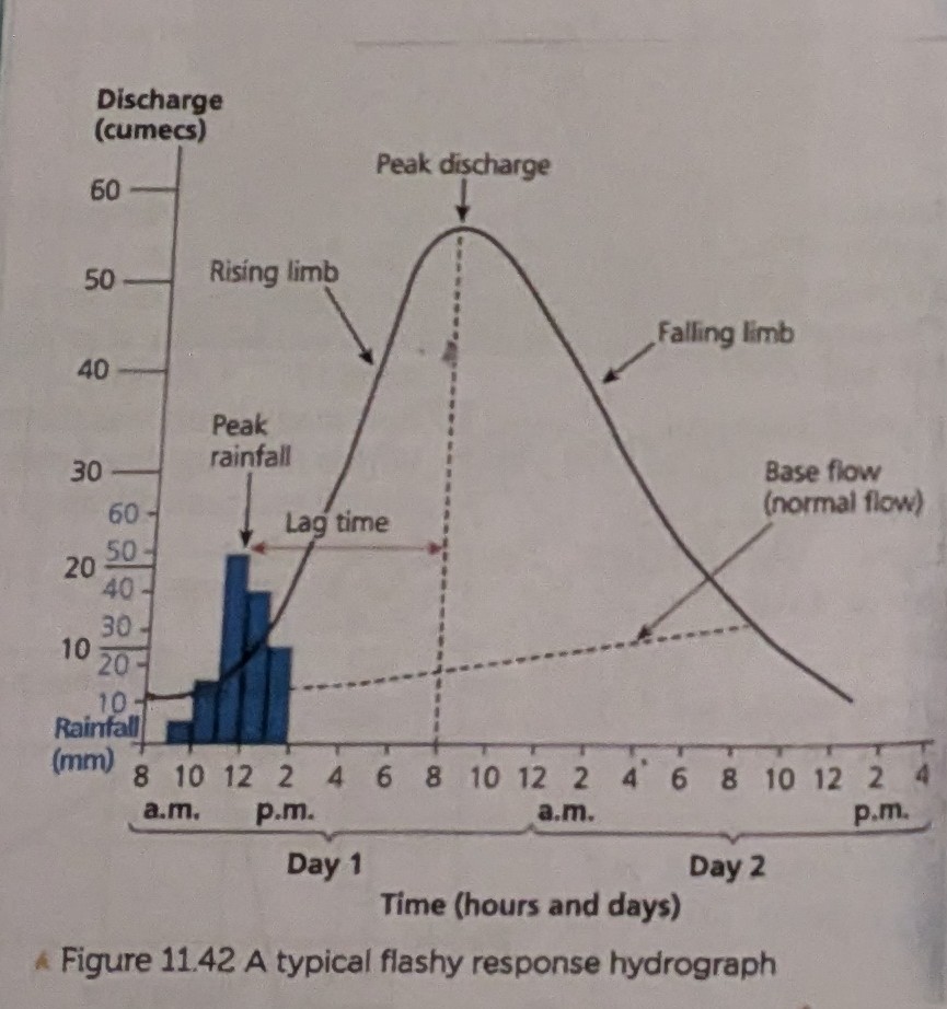
Hydrographs: why is the rising limb much slower than the falling limb?
The rising limb is fed by surface runoff, which reaches the river quickly over impermeable surfaces.

What is an example of a (local) flood management scheme?
Horsbere Brook Flood Alleviation Scheme, situated in Barnwood, Gloucester.
The horsebere brook is a tributary of the east channel of the river Severn in gloucester.
Why was the Horsbere Brook Flood Alleviation Scheme needed?
In June 2007, approximately 100 properties in the Longlevens area were flooded.
Some properties flooded to a depth of over 1 metre.
Less than a month later on July 21st, other areas including longlevens such as Hucclecote experienced flooding from the Horsbere Brook due to the Gloucester floods, where 90mms of rain fell in one day.
In total, 300 properties were affected.
In total, how many properties experienced flooding to the horsebere brook tributary?
300, after 90mms of rain fell in one day on July 21st.
Describe flooding around gloucester (due to the horsebere brook tributary of the river Severn).
It is frequent, and potentially severe.
It happened at least 3 times in 2008, requiring pumping by the fire service to avert flooding, and therefore costing a substantial amount.
This, and the risk to life led to the scheme being developed.
What did the Horsbere Brook Flood Alleviation Scheme involve?
The completed scheme provided flood storage to the area with a capacity to store over 170,000 cubic metres of water.
In normal conditions it will be nearly empty, but will fill when flows increase above the capacity of the flow structure.
It will remain until river flows have reduced.
How was the Horsbere Brook Flood storage area created?
By excavating 120,000 cubic metres of earth.
This earth has been used to make the hillside to the north and south to create a natural looking landscape.
The quality clay which was excavated to create flood storage area was then used to from a flood embankement along the western edge.
This provides further flood protection to the A40 carriageway, resedential areas and businesses to the west.
Horsbere Brook Flood Alleviation Scheme: what are the positive and negative social impacts?
-The scheme will provide protection from flooding with a 1% chance of occuring in this location in any year, meaning people will feel safer.
-The landscaped area has provided amenities for the local community to use, including an orchard.
.Ethical Issues with regards to cost of the scheme, whilst only protecting 350 houses.
Horsbere Brook Flood Alleviation Scheme: what are the positive and negative economic impacts?
-Less chance of flooding means that there will be less expensive damage to property, loss of stock and business and insurance costs will be lower.
.Cost of 1.5 million funded by Gloucestersire county council and the environment agency (through tax) which could have been spent elsewhere.
.Compulsory purchase of 50 acres of farmland by the environment agency to accommodate it.
Horsbere Brook Flood Alleviation Scheme: what are the positive and negative environmental impacts?
-The area has been landscaed using the dug out soil to produce a wildlife and amenity area with grazing marsh, reed beds, ponds and native woodland.
.A build up of willow and other vegetation reduces the capacity of the storage basin and relies on regular maintenance to clear it, from the ‘Friends of Horsbere Brook’ group.
.Made out of concrete, the storage basin is large and unattractive, leading to complaints.