Geog 1 - Lecture 3 : Maps, Projections, Latitude, Longitude, and Time Zones
1/19
There's no tags or description
Looks like no tags are added yet.
Name | Mastery | Learn | Test | Matching | Spaced | Call with Kai |
|---|
No analytics yet
Send a link to your students to track their progress
20 Terms
Define Map Projection
The reduction of a globe onto a flat surface
Define Mercator Projection
A cylindrical projection that preserves angles and shapes perfect for navigation but distorts size of landmasses (near the poles making then seem larger)
Define Gall-Peters Projection
An equal area projection that preserves area, but shape is heavily distorted
Define True Shape
The correct configuration coastlines mainly useful for navigation but distorts area
Define Equal Area
Indicates the equivalence of all areas on the surface of the map but distortions shape
What are the different ways in which maps are political?
Neutrality is impossible
can create biases
What was the rational for how time zones were created?
Trains
How are coordinates determined in maps?
Latitude (N/S), Longitude (W/E)
The longitudinal lines that run North-South are known at the ___
Meridians
The longitudinal line that represents 0° is the ___
Prime Meridian
The latitudinal lines that run east-west are known as ___
Parallels
The latitudinal line that represents 0° is the
Equator
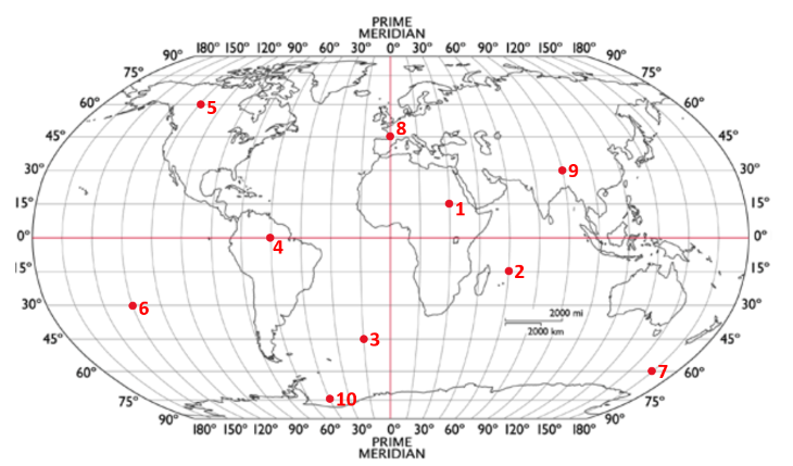
What is the coordinate for #1
15°N, 30°E

What is the coordinate for #4
0°N (or S), 60°W

What is the coordinate for #8
45°N, 0°E (or W)

What is the coordinate for #9
30°N, 90°E
The longitudinal line that represents 180° is the ___
International Date Line
Flying West across IDL causes ___
Going ahead 1 day
Flying East across IDL causes ___
Going back 1 day
Define Greenwich Mean Time
Formal world standard time now reported as Coordinate Universal Time (CTU)