GEO 425 Hydrology Final
1/71
There's no tags or description
Looks like no tags are added yet.
Name | Mastery | Learn | Test | Matching | Spaced | Call with Kai |
|---|
No analytics yet
Send a link to your students to track their progress
72 Terms
What is the source of most groundwater?
precipitation and infiltration
Infiltration
water moving from surface to subsurface
Percolation
water moving through the ground
Types of aquifers
- Confined vs. unconfined
- Polluted vs. non polluted
- High vs. low water availability
etc
What variables determine groundwater availability?
- climate
- compaction
- overuse
- etc idk
Water misconceptions
- Water always flows from high to low points
- water always flows from high to low pressure
- True: water always flows from high to low hydraulic head, elevation head, and pressure head
Confined aquifers
impermeable overlying layer with opening somewhere for recharge area
Unconfined aquifer
fully permeable, with full rechargeable area
Bernoulli: Steady and stationary flow
water is flowing at a consistent velocity (both magnitude and direction of flow stay the same)
- unsteady and transient flow: when magnitude and/or direction of flow change
Bernoulli's law
when one thing increases, the complementary thing decreases (?)
Vertical flow
water flows from deeper part to shallower part --> upward
porosity
percent of air within a soil column that is completely dry
permeability
the connectedness of pore spaces
Aquifuges
Rocks and soils that are neither porous nor permeable.
Aquitards
impermeable layers such as clay that hinder or prevent water movement
Artesian well
confined aquifer where water in well rises up higher in land surface; continuously pumping up because of weight and pressure
Perched groundwater and water table
small water table above an area that is not saturated (separated by underlying confining layer)
Potentiometric surface
imaginary surface that one obtains when connecting the hydraulic heads of an aquifer
Measuring hydraulic conductivity
Field techniques: borehole and pumping tests
Lab tests: core subsoils
estimate vs. absolute values
constant head permeameters
sample size and replication
Lakes
inland depressions containing standing water
- all over the world, but not evenly distributed (North America, high altitude locations)
How are lakes formed?
- Glacial erosion and deposition: Great Lakes formed from dead glacial ice in depressions; smaller kettle lakes; highest large lake in the world is Lake Titicaca in South America, formed by melted ice and snow filling a basin in the Andes Mountains
- Shifts in Earth's crust: tectonic lakes
- Craters of some extinct volcano: Caldera lakes
- Landslides: land slide blocks river and acts as dam (until lake erodes and blows it out)
- Oxbows: cut off river meanders
- Man-made: reservoirs (include many 'fingers' from dammed up, backed up tributaries)
Physical characteristics of lakes
- light: turbid lakes get darker at more shallow depths than clear lakes
- density: water gets less dense at warmer temperatures (or below 0C)
Lake stratification zones
- Ice (surface - if winter only)
- Epilimnion: top
- Thermocline: middle
- Hypolimnion: bottom
Lake overturn
- in temperate lakes, the changing of the seasons help move water in the lake (during Spring and Fall)
- tropical lakes often stay stratified because warm water always stays on the top
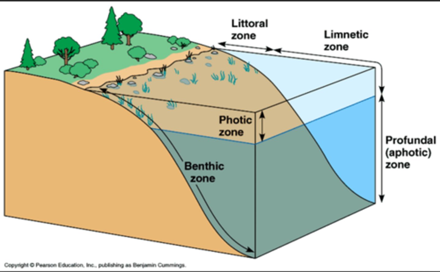
Lake zones
- Littoral zone: shallow water near shore
- limnetic zone: shallow water away from shore
- Photic zone: topmost layer of water
- Profundal zone: middle layer of water
- Benthic zone: deepest, bottom layer of water
Nutrient status: eutrophic systems
- lakes with high production
- associated with high nitrogen and phosphorus
- increase in growth of algae and other aquatic plants
- may experience oxygen depletion
- shallow murky water
Nutrient status: oligotrophic system
- water is clear and appears blue to blue green in the sunlight
- low production of organic matter, particularly phytoplankton
- oxygen concentration remains high
Nutrient status: dystrophic system
- nutrient poor peat bogs
- acidic, dark, humic waters
Human impact on lakes
- overfishing, pollution, and introduction of invasive species
- human activities can add heavy loads of silts and nutrients, especially N, P, and organic matter
Video: What happened to Tulare Lake?
disappeared when tributaries were redirected for agricultural purposes; came back after extreme floodings
Video: Precipitation events are expected to become:
more frequent and intense
Video: Subsidence and earth fissures
settling and fracturing of the ground because of groundwater and overuse
Video: Hot drought
drought driven by high temperatures
Video: wet years vs. dry years water sources
- Wet years: use surface water
- Dry years: use groundwater
Video: solutions to agricultural water overuse
- More efficient fertilizer applications
- repurposing non-productive areas
Video: Farming land use
Half of the world's land
Video: Colorado River Basin
- 15% of US crops come from here
- currently drying
Video: weather/water whiplash
severe droughts followed by severe precipitation events
Movie: Why were the dams built on the Elwha River
For hydroelectric power to develop logging and pulp mill industry
Movie: how did damming affect the Elwha River
- Salmon were blocked by the dam, so their populations dropped
- Reservoir increased predation and water temperatures
- Lack of sediment and woody debris transport
Movie: Who were the two primary parties
- Elwha tribe in favor of bringing down the dams because they relied on the river's ecosystem services
- Port Angeles and townspeople in favor of keeping up the dams because they relied on the employment and economic benefits provided by the dam
Movie: what were the ineffective solutions to salmon loss that maintained the dams
- Hatcheries to restore populations, but they were not well suited to the wild
- Legislation preventing natives from fishing
Movie: what was the legal reason for taking out the dams?
- dam licensure was up for renewal
- one of the dams was in the national park because it predated it, but you can't license a dam within the park
Movie: Elwha River Restoration Act
- passed by Congress in 1992 and signed by HW Bush for the government to buy and remove the dams
- action was delayed for decades
Movie: what was the primary conflict with taking out the dams?
Environmental impacts vs. economic impacts
Movie: when were the dams removed
2011-2013
Movie: how was restoration aided post-removal?
- planting native species along banks
- relocating adult fish to assist in reintegration
Movie: how long was the river dammed?
~100 years
Bart Study: Research question
whether and how forested land within an agriculturally dominated watershed alters stream nutrient concentrations
Bart study: major result
forest drainage basins have significantly lower nutrient concentrations compared to agricultural areas; forest cover is a stronger predictor of water quality than soil/geology
Bart Study: What does forest cover correlate with?
Better water quality; sites with forested drainage basins had lower concentrations of nutrients compared to more agricultural sites
Bart Study: What is measurable even in agriculturally dominated watersheds?
buffering effect of forest land; preserving forested areas can help mitigate nutrient pollution and protect stream water quality
Bart Study: is water-quality improvement absolute?
no, variability and localized hot spots exist; some forested area sites still showed elevated nutrient levels, so forest cover does not guarantee clean streams in all circumstances
Bart Study: What factor is most important in driving nutrient levels?
Land use (forest vs. agriculture); things like soil type and geology are not strong predictors of lower nutrient concentrations
Bart Study: Implications for watershed/environmental management
protecting and preserving forested lands (especially headwaters) within or upstream of agricultural watersheds is an effective strategy for reducing nutrient runoff and improving water quality in streams
Speaker: What does the Miami Conservatory District do?
- collects, analyzes, and manages water quantity and quality in the Great Miami watershed
- monitors changes in the water cycle and effects on the landscape
- Flood protection, water supply, and recreation
Speaker: What does the system consist of?
- 5 dry dams
- 55 miles of levees and floodwalls
- 185 floodgates
- 10,000 acres of natural floodplains
- 350,000 acres of land that stores water
Speaker: Change of water cycle
- over last 25 yrs, mean annual precipitation has mostly increased above the long term mean
- fewer dry days
- thunderstorms: intensity increase between april and june
- runoff: more runoff than the long term mean (same as precip
- surface component and baseflow: increasing
- evapotranspiration: not much change
Speaker: water cycle intensifying in region
- more flooding
- more storage at dams so levees don't overtop
- more streambank erosion
Speaker: adaptations for intensifying water cycle
- green infrastructure and stormwater management
- allowing streams the room to naturally meander and do what streams do
Field trip: Acton lake dam
- Earthen dam
- spills over concrete part automatically at high flow
- smoothness of spillway moves water quickly and prevents erosion
- residence time of months to years
- ^ droughts could have RT of decades, extreme storm events could have RT of days
Field trip: Rutger Preserve
- WPA built dam in 1930s
- built for water supply (municipality, agriculture)
- built for recreation (swimming hole)
- dam breached
- holds less volume of water than Acton lake and maintains flow
- low head dam
- removing dams because of safety, environmental impact (species isolation, sediment load, water temperature, methane emissions), water supply
Field trip: Peffer Park
- dam blown out, so stream is incising
- privately owned before for natural hockey rink, now Miami's
- planned to remove and create step pool
Beavers
nature's engineers; make channels more swampy and more like true natural state
Darcy's Law (Q)
Q=-KiA
Q = discharge (m^3/day)
K = hydraulic conductivity (m/day)
i = hydraulic gradient (unitless)
A = area (m^2)
Hydraulic gradient (i)
i = change in h/change in x = h2-h1/x2-x1
Volume flux density (q)
q = Q/A = -Ki
(m/day)
Hydraulic conductivity (K)
K = -q/i
q = volume density
i = hydraulic head
Infiltration depth
P/(ne-theta)
P = precipitation
ne = effective porosity
theta = volumetric water content
Infiltration velocity
Ve=f/(ne-theta)
f = Infiltration rate
ne = effective porosity
theta = volumetric water content
Effective velocity (Ve)
Ve = q/ne
q = volume flux density
ne = effective porosity
Effective porosity (ne)
ne = q/ve
q = volume flux density
ve = effective velocity