GEOL 103 Final KSU
1/48
There's no tags or description
Looks like no tags are added yet.
Name | Mastery | Learn | Test | Matching | Spaced | Call with Kai |
|---|
No analytics yet
Send a link to your students to track their progress
49 Terms
Geologic maps
Depict the distribution of rock units at Earth's surface using colors, lines, and special symbols.
Geologic cross sections
Arrangements of formations and their contacts along a vertical slice of earth.
Block diagrams
Combine a geologic map and cross-section to depict geologic formations exposed on the surface and in the subsurface.
What does each color on a geologic map represent?
Geologic unit
What does the second and third letters of the name abbreviation symbol for geologic units represent?
The specific name of the geologic unit
The outcrop pattern of a vertical bed on a horizontal surface is narrower than a dipping unit of the same thickness.
True
When eroded to a horizontal surface, synclines (and basins) have the youngest beds exposed in the outside and the beds become progressively older toward the center
False
When eroded to a horizontal surface, anticlines (and domes) expose the oldest beds in the center and the beds become progressively younger outward.
True
The angle of tilt at right angles to the strike.
Dip
Gradient formula
RISE over RUN (vertical distance/horizontal distance)
What is NOT a landscape feature you might encounter on a topographic map?
Brindle
Contour lines
Generally do not intersect each other and are not only used for representing elevation on topographic maps.
A contour line is only used for representing elevation on topographic maps.
False
Generally, contour lines do not intersect each other.
True
If a hilltop is at an elevation of 1000 feet and the valley below has an elevation of 250 feet, then what is the relief?
750
On a topographic map, declination is the difference between magnetic north and true north.
True
There is a hyperlink in the pre-lab reading for downloading free topographic maps from the USGS.
True
A stream starts at its mouth and ends at its headwater.
False
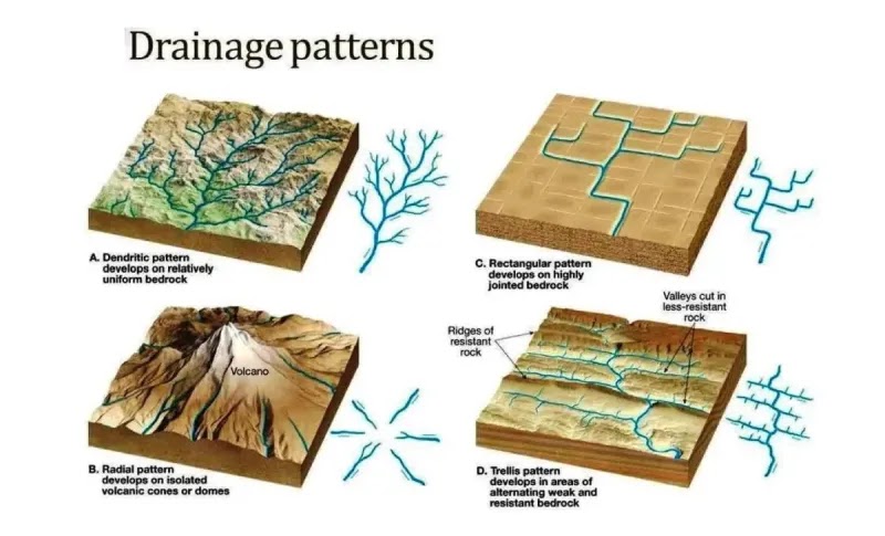
What Drainage patterns are shown?
A. Dendritic
B. Radial
C. Rectangular
D. Trellis
A continental divide separates watersheds that flow into one ocean from those that flow into another ocean.
True
Relief
The difference in elevation between the hilltop and the valley.
Declination on topographic maps is…
The difference between magnetic north and true north.
Continental divide
Separates watersheds that flow into one ocean from those that flow into another ocean.
Discharge of a stream
Calculated using the cross-sectional area and average velocity; for example, 30m² area with 10m/s velocity results in 300.
The ability of a stream to erode its bedrock depends on the velocity and _______ of water and on the amount of sediment present within the water.
Volume
Cutbanks
Result from erosion occurring on the outer edge of meanders.
Delta
A wedge-shaped deposit formed from accumulated sediment.
A risk is a potential source of harm or adverse effects to a person or persons.
True
What is the annual probability for a "50 year" flood to occur?
50%
According to the pre-lab reading, the most recent major flood to affect the Kansas River was in 1993.
True
Recharge zone
An area where groundwater is replenished.
Where discharge (or extraction of water via wells) is less than recharge, the volume of groundwater is reduced.
False
Aquifer
A permeable rock unit that stores and/or transmits groundwater.
In arid environments, physical weathering is more important than chemical weathering due to lack of water.
True
In arid climates ________ and _________ are physically and chemically resistant ridge formers.
Limestones and Sandstones
Typical description of arid landscapes.
Angular
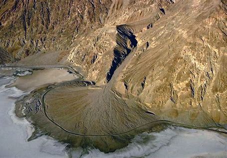
What is this an exampe of?
Alluvial Fan
Ergs
Vast areas covered by sand dunes in arid or semiarid climates.
Dune shapes only result from wind direction.
False
Saltation
The process where large sand grains bounce or hop along the surface during wind transportation of sediment.
Sand dunes will NEVER migrate from their original location.
False
Playa lakes / salt pans
Result when evaporation exceeds both precipitation and runoff, leading to salt precipitation as the lakes dry out.
A farmer is drilling a well on the top of a hill with an elevation of 550ft. The depth to the unconfined aquifer below is 80ft. What is the hydraulic head in ft.?
470
Hydraulic gradient
The hydraulic gradient is calculated by taking the difference in hydraulic head between the two wells and dividing it by the distance between them.
Another farmer drilled two wells, one with a hydraulic head of 500ft. and another well 0.5 miles away from the first with a hydraulic head of 430ft. What is the hydraulic gradient between the two wells in ft/mi?
140 (70ft divided by 0.5 miles, equaling 140 ft/mi. )
Hydraulic head
The height of the water column above a reference point, calculated from the top of the hill and the depth to the aquifer.
Groundwater can always be recharged very quickly. It will never take thousands of years.
False
Karst topography
Expresses groundwater dissolution on Earth's surface.
Environmental protection agency
Assists businesses or landowners in removing contaminants from groundwater.