Basic Landforms and Terrain Features in Physical Geography
1/77
There's no tags or description
Looks like no tags are added yet.
Name | Mastery | Learn | Test | Matching | Spaced | Call with Kai |
|---|
No analytics yet
Send a link to your students to track their progress
78 Terms
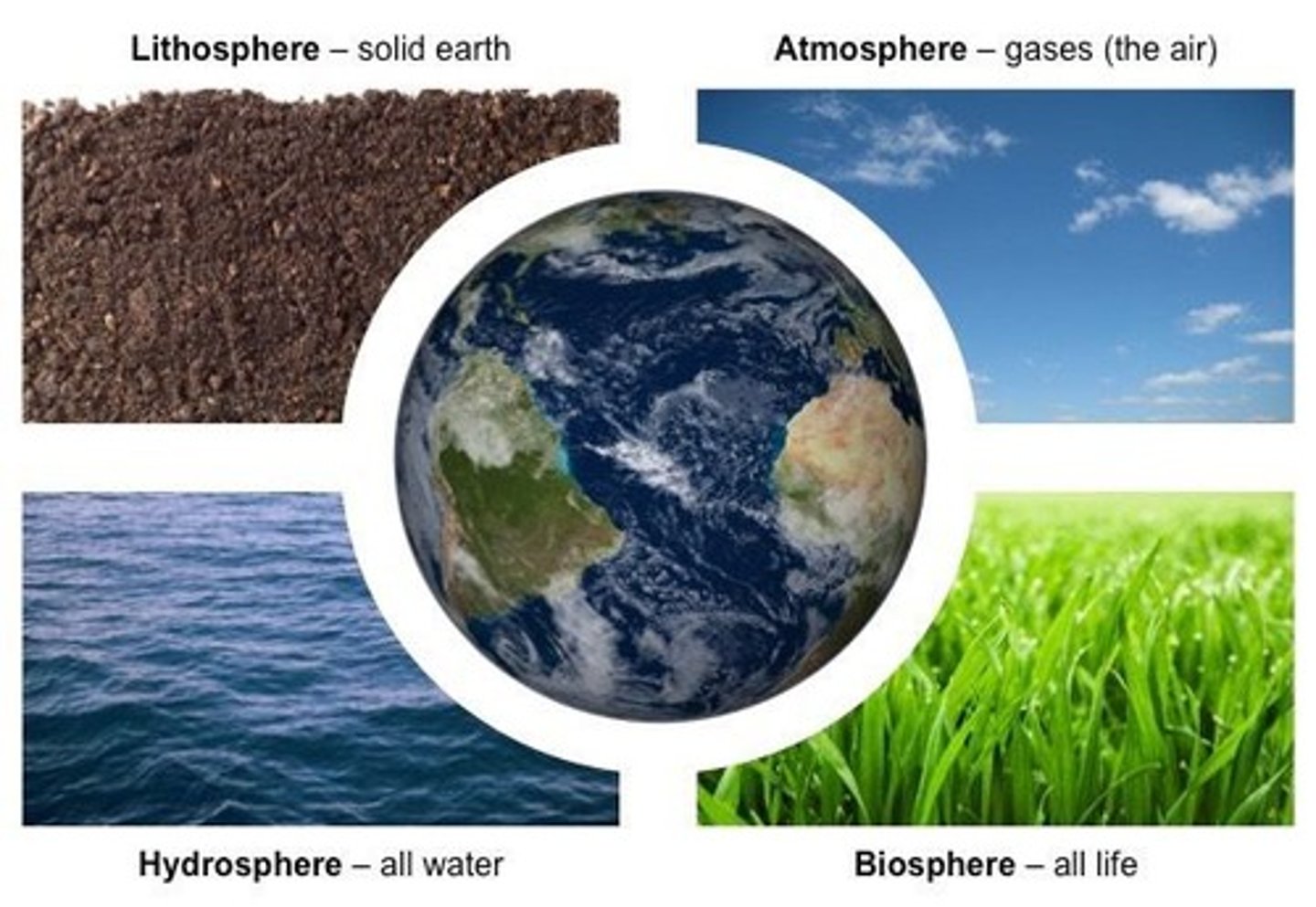
What is the biosphere?
The region of habitable life that overlaps with the other three spheres.
What does terrain refer to?
Land, especially considered with regards to its physical features.
What is topography?
The study of terrain, expressed in terms of elevation, slope, and orientation of landforms.
Define elevation in the context of landforms.
The height of a landform above sea level.
What is slope in geographical terms?
The angle of the landform relative to horizontal, also called 'grade'.
What does orientation refer to in landforms?
The location or position of the landform relative to compass points.
How does terrain affect human settlement?
Flatter, alluvial plains tend to have better farming soils than steeper, rockier uplands.
Why is understanding terrain important for environmental quality?
It helps understand watershed boundaries, drainage characteristics, water movement, and impacts on water quality.
How does terrain influence weather patterns?
Geographically close areas may differ in precipitation levels due to elevation differences.
What is a landform?
A feature on the Earth's surface that is part of the terrain, such as mountains, hills, plateaus, and plains.
What are the four major types of landforms?
Mountains, hills, plateaus, and plains.
How are mountains formed?
Through tectonic forces or volcanism that raise the surface of the earth.
What is the difference between a hill and a mountain?
A hill is universally considered to be less tall and less steep than a mountain.
Define a plateau.
A highland area of relatively flat terrain raised significantly above the surrounding area.
What are the three types of plateaus?
Intermontane, Piedmont, and Continental.
What characterizes a plain?
A flat, sweeping landmass that generally does not change much in elevation.
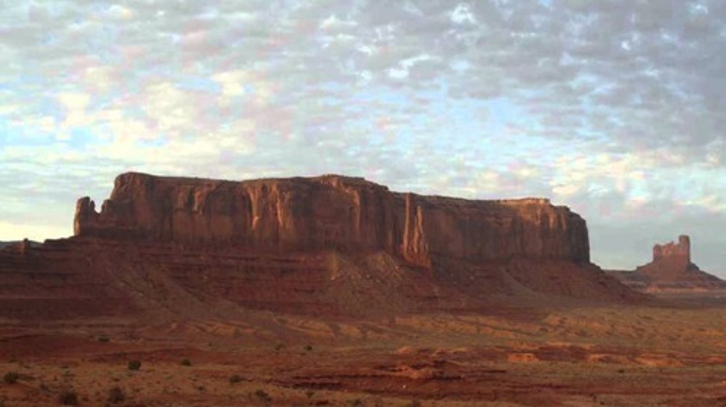
What is a butte?
An isolated hill with steep, often vertical sides and a small, relatively flat top.
How does a canyon form?
Through weathering and the erosive activity of a river over time.
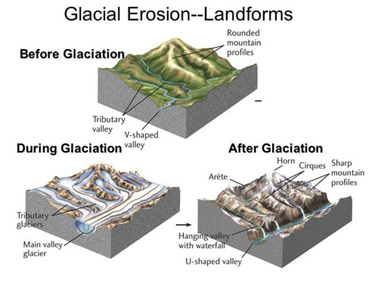
What is the difference between U-shaped and V-shaped valleys?
U-shaped valleys are formed by glacial activity, while V-shaped valleys are formed by river erosion.
Define a basin.
A depression in the Earth's surface, shaped like a bowl, with sides higher than the bottom.
What are the major types of basins?
River drainage basins, structural basins, and ocean basins.
What role do glaciers play in landform creation?
Glaciers can erode land and create landforms like valleys, cliffs, and canyons.
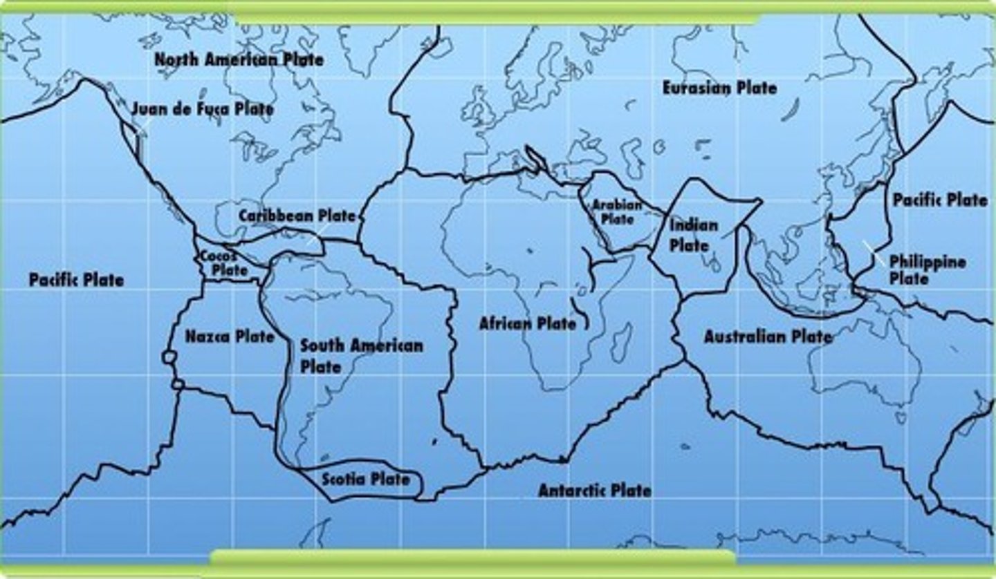
How do tectonic plates contribute to landform creation?
They move under the Earth's surface, pushing up mountains and hills.
What is erosion?
The process by which water and wind wear down land and create landforms.
What is the significance of precise terrain knowledge in aviation?
It is vital for low-flying routes, maneuvers, and airport altitudes.
What is the general rule for distinguishing mesas and buttes?
A mesa has a top wider than its height, while a butte has a top narrower than its height.
What causes changes on the Earth's surface?
Interior forces operating on the crust and exterior forces like moving water, air, and ice.
What characterizes plains?
Generally level or gently rolling land surfaces with low elevation and little local relief.
Where are plains often found?
Along the coasts of continents or islands and in large inland areas.
What is a flood plain?
A narrow linear plain formed by the erosional action of a river.
What defines a plateau?
A large area of level or gently rolling land standing above the surrounding areas, often with little local relief.
What is an escarpment?
A sharp drop-off between the surface of a plateau and the lower land next to it.
What is the elevation range for hills?
Greater than 500 feet but less than 2,000 feet.
What defines mountains?
Areas with elevation usually greater than 2,000 feet, characterized by steep slopes and narrow divides.
How do mountains influence climate?
They affect the climate on their windward and leeward sides.
What is the difference between 'site' and 'situation' in geography?
'Site' refers to the natural characteristics of a location, while 'situation' refers to its relative location to other areas.
How do landforms influence human activity?
They affect climate, soil, vegetation, and can encourage or discourage human movements and economic activities.
What is an example of a dissected plateau?
The Ozark Highlands or Ozark Plateau.
What is the typical land use pattern in Honshu, Japan?
Most people live on level land, which is used intensively for agriculture.
What is the cultural impact on land use in the Midwest of the United States?
Settlement patterns are geometric, following survey systems due to large areas of level land.
What geographical feature influenced settlement patterns in the Appalachian region?
The presence of lowlands to the east, west, and south of the mountains allowed people to choose alternative routes.
What are the characteristics of hills?
Elevations greater than 500 feet with slopes that are usually moderate rather than steep.
What is the local relief in mountains?
Usually more than 2,000 feet.
What role do cultural factors play in landform influence?
Cultural factors like technology and desire significantly determine human decisions regarding land use.
How do landforms affect transportation?
Mountains can discourage movement and make transportation routes more difficult.
What is the significance of the Hudson-Mohawk valleys and Cumberland Gap?
They became important transportation corridors in the Appalachian region.
What happens to plateaus in humid regions over time?
They may become dissected plateaus due to accelerated erosion.
What is the relationship between landforms and population density in Japan?
Population density is higher in areas of level land, which are more suitable for habitation.
What is the main characteristic of a dissected plateau?
It appears as a region of hills due to erosion but originally had horizontal layers of rock.
What is the impact of landforms on economic activities?
Certain economic activities are more likely to occur in specific landform areas.
How do human geography and physical geography intersect?
Both must consider landforms as they significantly influence human activities and settlement.
What geographical features limit settlement choices and channel transportation?
Mountains and hills
What are the important transportation corridors in the Appalachian area?
The Hudson-Mohawk valleys and the Cumberland Gap
How do mountains influence human settlement?
They limit settlement choices and channel transportation routes.
What is the impact of level lands on human development?
Level lands like plains are less restrictive and easier to cultivate.
What is submergence in geographical terms?
The decrease in elevation of a landmass, flooding valleys and former coastal plains.
What does emergence refer to in geography?
The increase in elevation of a landmass, extending coastlines onto former continental shelves.
How did the submergent coastline of the U.S. East Coast affect port city development?
It provided many naturally good locations for port cities.
What challenges did the emergent coastline of the U.S. Gulf of Mexico present for port development?
It had few good locations for large ports due to island bars preventing access.
What technological advancements allowed Houston to develop as a major port after 1945?
Modern technology enabled the opening of a channel for large commercial ships.
What was the German plan for invading France before World War I?
To march across neutral Belgium or through neutral Switzerland.
Why was the plan to march through Switzerland rejected?
The mountainous terrain made it less feasible compared to the plains of Belgium.
How do landforms influence soil development?
Steeper slopes tend to have thinner soils due to erosion and gravity.
What type of vegetation is supported by thin, poorly developed soils?
Plants that can grow in such conditions, typically found in hilly or mountainous areas.
What is altitudinal zonation?
The practice of different types of agriculture at varying elevations.
How do mountains affect precipitation patterns?
Windward sides receive more precipitation, while leeward sides are drier.
What is the relationship between elevation and climate in mountainous regions?
Temperatures decrease at higher elevations, leading to varied climates.
What problems can low-elevation plains present for human development?
They may have drainage issues leading to swampy conditions.
How did early settlers in New Orleans adapt to high water tables?
They buried their dead above ground and built houses without basements.
What role does bedrock play in groundwater movement?
Porous bedrock allows water to pass through quickly, while impermeable bedrock retains water.
What agricultural challenges can arise in areas with impermeable bedrock?
Farmers may need to drain land that is too wet for profitable use.
How does culture influence human assessment of land usability?
Different cultures may have varying views on the usability of land based on technology and historical experiences.
What is the significance of the Mississippi River floodplain for agriculture?
It has rich alluvial soils developed from thousands of years of sediment deposition.
Why are hilly regions less prone to waterlogged soil?
Higher elevations have more runoff, reducing the likelihood of waterlogged conditions.
What is the general rule regarding soil thickness on steep slopes?
The steeper the slope, the thinner the soil tends to be.
What influences the types of crops grown at different elevations?
Climate variations and temperature differences at various elevations.
What is the impact of erosion on soil in hilly areas?
Erosion removes weathered materials, leading to thinner soils on steep lands.
How do landforms affect human activity?
Landforms influence transportation, settlement patterns, climate, soil, and vegetation.